Showing posts with label Hillside Pond. Show all posts

Monday, May 8, 2023

Hillside Pond & Headquarters Path (Blue Hills Reservation)

Hillside Pond & Headquarters Path (Blue Hills Reservation)

Hike Type: Out & Back with a side of spaghetti
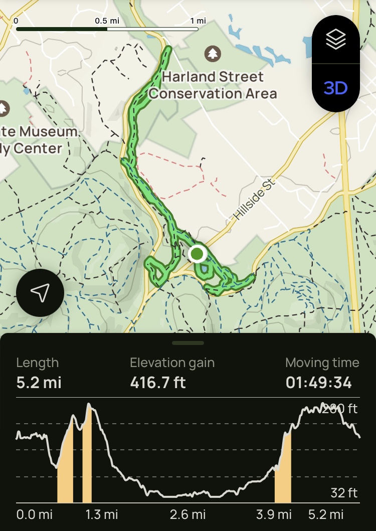
Distance: 4.70 miles
Elevation: 348 feet
Time: 1 hour, 46 minutes
Hiking Challenges: Blue Hills 125-Mile Challenge (2x); 52 Hike Challenge


The Hike
Confession time: (to no surprise) I’ve fallen pretty behind on my journaling, and I’m reminding myself that that is okay! Last week was my “chorus-palooza” where I had a rehearsal, dress rehearsal, school-wide concert, and then a field trip to the Massachusetts State House all back-to-back, so my brain has been rather occupied. It’s currently May 31st, 2023 and I’m sitting in the Boston Public Library in Copley Square because I foolishly thought I could just walk into the RMV (why on earth does Massachusetts call it the RMV instead of the DMV?), but I couldn’t really go home because I walked to Forest Hills and need to be at Tufts for a lung function test at 12:30… so here I am! It’s actually beautiful in here and I wish I came here more often, but that’s a post for a different blog that does not yet exist. Onto the hike!


After my long jaunt in the Ossipees I wanted something a little more chill, and I still needed the Hillside Pond/Headquarters Path area, which perfectly fit my criteria! There was lots of poison ivy at the trailhead, which I am proud I was able to successfully identify! I started with the abysmal loop around Hillside Pond, which could really use some love. It’s such a beautiful area, but such a janky trail. It was decently buggy on this loop, but nothing biting. There were a couple guys fishing in different spots on the pond, which I haven’t seen before. We managed to avoid each other, which is a win for me! There was one random skull perched on a tree, though...


After the loop I took one of the unofficial trails to meet up with the trails behind the pond, and I couldn’t help but admire how the sun was shining through the overcast (which in reflection I think was actually haze from the Canadian wildfires), creating a lovely early golden hour. I also had a major win: successfully swatting at and killing a small bug! (I'm also now realizing that part of the yellow hue to all these photos is the pollen in the air...)


Back at Hillside Street, I crossed the road and continued my hike along the Border Path, paralleling Pine Tree Brook, which was fully covered in beautiful skunk cabbage. I took the out-and-back on Valley Path, which was uneventful, and saw my first tick at 1224! It was on a tall piece of grass reaching out its grimy paws looking to suck any innocent passerby’s blood. EVIL. 


The long out-and-back to Hartland Street was rather uneventful minus one snake, being constantly paranoid that the moles on my leg were ticks, and noticing a couple walking their dog on the private property through the woods. Oh, and at least 50,000 ant hills on the dike! 


I wrote in my notes “felt heavy and week today. ugh.” - but in reflection, that was most likely due to the physical abuse I put myself through a couple days prior. Progress isn’t linear! My final note for this hike was that I felt it was rude that this particular hike ends with an uphill, and I stand by that statement! All in all, I was able to get out, even if this hike didn’t give me the warm fuzzies, and that is okay!


Step-By-Step
- Park at Hillside Pond Parking on Hillside Strees.
- Start hike by hiking loop around Hillside Pond. 
- Near end of hike, turn right onto unmapped steep uphill path that connects to Barre Trail. 
- At terminus of unmapped trail, turn right onto Barre Trail. 
- Hike trails in this area, and then retrace steps to Barre Trail Trailhead on Hillside St.
- Cross Hillside St, continue hike on Border Path.
- At 1224, turn left onto Valley Path.
- At Chickatawbut Road, turn around.
- At 1224, continue straight/left onto Border Path.
- At 1215, continue to Unquity Road.
- At Unquity road, turn around.
- At 1215, turn left onto Massasoit Path.
- At terminus, turn around and retrace steps to Hillside St. 

Friday, March 10, 2023

Hillside Pond, Border Path, Bermuda Triangle (Blue Hills Reservation)

Hillside Pond, Border Path, Bermuda Triangle (Blue Hills Reservation)

Hike Type: Spaghetti
Distance: 5.40 miles
Elevation: 417 feet
Time: 1 hour, 50 minutes
Hiking Challenges: 52 Hike Challenge; Blue Hills Winter Trace


The Hike
Friday afternoon hike! I slowly made my way from Arlington to the Blue Hills and parked at the pull-off for Hillside Pond. Overall, this hike was quite uneventful, but moreso a very relaxing walk in the woods. I waited in my car for a moment before starting since someone pulled in directly behind me, and I'm dreadfully antisocial. He ended up being a mountain biker, which I think is technically against the rules this time of year? Not sure.

My hike started on the loop around Hillside Pond, which is kind a rough trail. Lots of litter, very narrow and rough footing, but a few nice viewpoints. I have a vauge memory that this pond used to be used for ice harvesting, but I could have FULLY made that one up. The air was very still this day, which allowed for some lovely reflections in the water. The far side of the pond had the most litter, some graffiti, and an illegal fire ring, which I found interesting. No one gets caught doing this stuff?? There were a few trails branching off in different directions that are not on the map, too. 

I planned to hike the rest of the trails on this side of the street, but another human deterred me (#antisocial), so I headed onto the Border Path next! The Border Path descends along what is labeled as the Pine Tree Brook (which I guess is different than the Pine Tree Brook Path on the Quarries side?) through some beautiful woods, crosses the brook, and then comes to the split with Valley Path. I ascended back up the Valley Path, and then risked my life crossing the street to hike what I've started calling the "Bermuda Triangle" - the weird parcel of land between Chickatawbut and Unquity. I followed the road to the western entrance of the Unquity Path, which was a very unpleasant part of the hike - lots of litter, foul smells, and speeding vehicles. The Unquity Path itself was shockingly beautiful - very tall trees with just enough space between them and a very soft ground underneath. The sun did an excellent job shining through. There were also my favorite mysterious yellow blazes! At the eastern teminus, I followed Chickatawbut Road for a bit to hike the last bit of unnamed trails in the Bermuda Triangle, before crossing the road again and descending the Valley Path, admiring the extra mountain biking trails that are not on the map.

Back at the intersection with Border and Valley, I noticed a large, seemingly manmade hill off to the side. Curious the history of this - how have no trees grown? The Border Path continues on along private property, apparently belonging to R.L. Gregg, who has posted MANY signs, my favorite of which being about 10 feet of fence with a gate (with no fence on either side), stating that seasonal hunting occurs on that land. Further down I ran into the sweetest, most terrified dog and her kind owner, whos legs she hid under when she saw me. 

The trail terminates at Unquity Road, and then I turned around to turn onto the Massasoit Path. There were some very unique and unpleasant smells in the swampier areas, but conversely some beautiful strems going around the trail. The trail then opens up to the large dike that parallels Unquity Road, ultimately terminating back at the Pine Tree Brook. Now it was time for the long backtrack to Hillside Pond. I did get a lovely surprise view of Hancock Hill behind the trees from the dike, which was exciting! I passed another possibly illegal biker, but the rest of the return trip was uneventful.

Once back at the pond, I had a few more trails to hit before it got dark. I followed the Barre Trail into the woods on the oppsite side of the road of the Border Path, and then wiggled my way around until I hit everything. There were plenty of horse hooves and a decent amount of litter closer to Chickatawbut Road. There were some great stone walls, and one slightly tricky creek crossing. I made it back to the car just in time for the headlights to come one, and then it was couch time!


Step-By-Step
    - Park at Hillside Pond parking area.
    - Start hike with loop around Hillside Pond.
    - Back at parking area, cross the road and start hike on Border Path.
    - At 1224, turn onto Valley Path.
    - At terminus, cross road and turn left to follow road.
    - Turn left onto Unquity Road.
    - Turn left into woods onto Unquity Path.
    - At terminus, turn left onto Chickatawbut Road.
    - Turn left into woods onto unnamed path.
    - Cross road, hike Valley Path back to 1224.
    - At 1224, turn left to continue hike on Border Path.
    - At 1215, hike spur to road and then continue hike onto Massasoit Path.
    - Hike to terminus, retrace steps all the way back to parking area.
    - Back on the Hillside Pond side of the street, hike the Barre Trail to the Headquarters Path and other trails in the area.
    - Return to car.