Mt. Tammany, Dunnfield Creek, Holly Springs, & AT (Worthington State Forest)
Hike Type: Lollipop Loop
Distance: 8.72 miles
Elevation: 2,215 feet
Time: 3 hours, 27 minutes (3 hours, 13 minutes moving)
Hiking Challenges: N/A
Hiking Challenges: N/A

The Hike
A silly pattern in my hiking this summer is that I simply cannot be bothered to think about where to hike, so I've been very locked into repeats, which is not a bad thing! Naturally, this is mostly the Tourne, which is just a few minutes' drive from my Mom's house, but apparently it also applies to Mt. Tammany, becuase I could not stomach the mental faculties required to hike anything else (keeping in theme, I also flirted with Bear Mountain again, but wanted to limit time-in-car). ANYWAY, that being said, the plan was to do the same extended loop around Mt. Tammany as last Monday!
I was out the door just after 7:00am and drove past a wild backup on I-80 East (thank goodness I was driving west) - apparently a truck spilled over in the early hours of the morning and they had to shut down the interstate. I stopped at the Delaware Water Gap Service Plaza to use the bathroom and get an extra bottle of water (I only brought two, but with the humidity I was thinking one more couldn't hurt!). While sitting in the car, I decided I was feeling adventerous and was going to extend my already-extended hike by driving to the Farview Trail and adding on that trail to form a lollipop-loop (which would add 1.4 miles each way). I drove to Exit 1 off I-80, waited at the long light on Old Mine Road, and just after turned onto the Farview Trail parking area, which was a decently hidden gravel road that opened up to a large parking area for at least 20 cars. Across Old Mine Road is the former Karamac Trail parking area, but it has since been blocked off (making a deducation from maps and trail reports, I'm guessing it's been abandoned due to erosion).
I saw a bunny at the trailhead as I got ready. Temperatures were in the low 70s but the humidity was other-worldly. It was wonderfully un-buggy, but I put bug spray on anyway. My camera lens immediately fogged up, which ended up being a literal and figuative uphill battle for the rest of the hike. I soon started my hike on the yellow-blazed Farview Trail (which apparently is also known as the Beulahland Trail according to the National Park Service), which entered the woods on a nice footbed with understory on either side. The trail soon split, with the blazes continuing on the right (I'm guessing this is a reroute, likely due to erosion).
The Farview Trail zig-zagged through ferny woods and soon rejoined the older footpath, which felt like an old road. I was overjoyed with the surprisingly pleasant and easy climb up to the "Not-Kittatinny Ridge" (my name for the ridge the AT follows in Worthington, while the Mt. Tammany Fire Road traverses the main ridge). The trail split again, with both forks continuing parallel to each other as the trail made a very wide turn. I stayed to the right. There were no blazes indicating which way was "correct." There were some slippery slabs here, but they weren't steep so as long as I didn't walk like a fool I was completely fine!
Near an open area where the two forks rejoined, the humidity was so thick you could see the sun rays. My camera lens continued to be a mess, but I had gotten it to a point where I could take somewhat nice photos. The trail flattened out for a bit, which is apparently where all the bugs had been hiding out. I swatted at the bugs while the trail parallelled two parallel rock walls, occasionally running into some spider webs, which increased the futher along I hiked. At least I wouldn't have to swat them down on my return!
There was a walk-through blowdown right at a 1.0 mile mark and the Farview Trail soon traverses the trail's height-of-land, which had a piece of pink flagging tape on a bush. From here, the trail descended slightly past some impressive off-trail spider webs and then barely rose to the terminus with the Appalachian Trail!
I turned right onto the Appalachian Trail and I crossed paths with someone who appeared to be a thru-hiker. I could hear some voices through the woods, eventually passing two other hikers who did not appear to be backpacking. The trail here really is wonderful. A short, moderate, rugged descent followed by wonderful fern-lined walking followed by another, easier moderate descent and then easy walking for the rest of the way.
I hiked past what looked like the numbers "1800" made out of sticks and rocks, which I assume was to indicate a mileage milestone for the AT, but in my head I'm pretty sure NJ is more than 400 miles from Kathadin, but maybe not?
A bit further down, I passed a group of backpackers in the same spot that I saw the bear last week. Here, the trail briefly splits into two. The backpackers were on the right fork, which was a narrow footpath. I followed the left fork, which was much wider. I'm guessing the narrower side is a bypass for when the main trail is flooded after rain. From here, I could hear the creek and voices down below, and soon I could see the trail down below, too!
Now following Dunnfield Creek, I was wowed (as always) at the natural beauty, and I do understand why people (break the law and) go swimming here. I continued on until the sound of the creek flowing was slowly replaced with the sound of trucks zooming by on I-80. The massive blowdown near the AT's exit to the parking area had been cleared, and I took a quick bathroom break at the porta potty before emotionally getting ready for the climb!
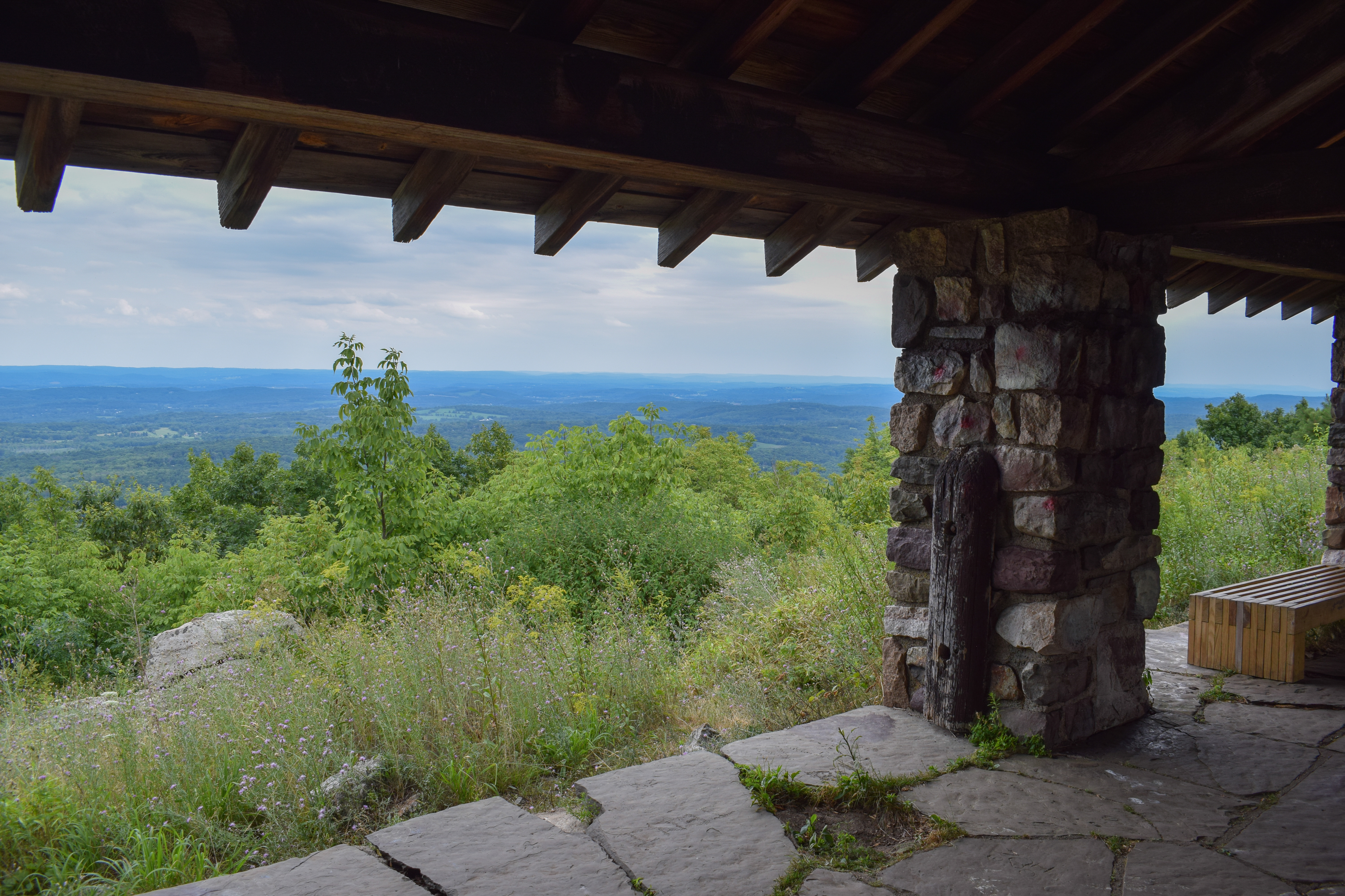
I was curious how this climb would go after I had the best climb ever last week, and now I was doing it on tired legs in air that was made of soup. I had hardly started phase one of the climb when I was already fighting for my life - this would be a fun one! The air was THICK, and I was cursing the Earth by the time I made it to the views near the end of climb one. Thankfully, the view was wonderful as always! I was comically wet with sweat already, and it was only going to get worse! Only good thing was that the bugs were staying down low.
I hiked past a family of turkeys as I approached climb two. I heard a few folks ahead of me, but I was hoping to not pass them as I was taking it SLOW. At this point, I was hiking directly into the sun and I was simply ready to pass away. I passed my first people since the AT early on in climb number two and my heart was PUMPING. I was simply not feeling great, but taking it slowly with many standing breaks.
Climb three was more physically sustainable but I was still fighting for any ounce of life I had left in my body. My hands were prunes from the constant inundation of sweat. Just as I thought all hope was lost, I heard voices, and then I was at the top! I visited the open area on the left before descending onto the viewpoint, which was lovely and full of vultures circling below. There were a few friendly people enjoying the view (AND BREEZE!), but I didn't stick around. I quickly retreated back into the shade.
I took standing break at the start of the Pahaquarry Trail and wrung out my shirt, which was somehow holding onto more liquid than all three of my water bottles combined (or at least it seemed...). My watch was comically telling me that I had climbed 10,000 feet, which was horribly incorrect, even if it felt like it. My iPhone was too sweaty to take notes, so I had to switch to using voice-to-text, and once I was feeling marginally better, I continued on!
There was a wonderful breeze on the ridge and it felt significantly cooler, which was just a wonderful treat. I nodded at the fire road, vowing to follow it one day to Sunfish Pond, but that day would not be today. Unfortunately, the descent was not any less rough or rocky, but in reality, it's only the one upper stretch that is rough, everything else is literally fine. I found myself wondering how long a true Kittatinny Traverse would be - following the high point on the ridge via trails from PA to NY (according to AllTrails, somewhere around 45 miles and under 7,000 ft of gain - legally doable in a 24 hour period)!
I slowly descended into a warm, humid, buggy hellscape (that's dramatic, it was fine). The sounds of Dunnfield Creek and people swimming began to fill the air, and then I turned right onto the green-blazed Dunnfield Creek Trail, which was a little wet at first but soon dried out. The trail is so pretty for the whole segment, but especially the first bit, where the trail gently follows the creek as it flows over mossy rocks and slabs. It even smelled like flowers!
The Dunnfield Creek Trail traversed a more open section where it was dreadfully hot and humid. I hopped over a frog on a super easy creek crossing and then slowly climbed up the stairs to the relocated stretch. I spent a decent amount of time trying to find information on the fire that went through this stretch and when it went through, but I couldn't find anything besides a fire off of Old Mine Road in the past year and a fire along the Red Dot Trail in 2020 - the mystery continues!
I did see a five-lined skink climbing a tree, though! It moved too fast for me to get a photo, but it was an exciting sight! I find it interesting how I didn't even know they existed until this year, but now I've seen three! Afterwords, I was back on the old trailbed with sausage fingers full present and soon I was getting ready to cross Dunnfield Creek. I wanted to dunk my head, but there were so many water bugs that I was quickly dissuaded.
I easily crossed the creek, continued along the trail, crossed another easy stream, and made it to the Holly Spring Trail. I took another short break here for water while I dreaded the next climb. Thankfully, the climb was actually quite easy and I was just being dramatic (what else is new). The woods here are so pretty, but after crossing a little trickle of a stream, the bugs were officially back. They had me hiking faster than I wanted to (and faster than my body allowed me to).
I cruised (with a high heart rate) past the junction with the Appalachian Trail and back onto the Farview Trail. The bugs were pretty brutal here, but again, at least the woods were pretty! I hiked up and over the height of land and began my gentle descent. I stayed right when the trail split in the slabby area. The slabs were now dry which was a win!
In the next stretch of trail, I saw a bear! This encounter was much less stressful and only exciting, as the bear was far down in the woods. I got a few photos with my camera but my sweaty fingers couldn't get my phone's camera open in time. It looked smaller, maybe a cub, but there were no other bears nearby (that I know of at least). Soon after, I hit the relocated zig-zag stretch, and then I could see my car!
I hurried myself out of the woods, as the bugs were the most brutal at the end. To my surprise, there were no bugs in the parking lot once I was out of the woods. There was one other car in the parking lot now, a Tesla with a sleeping woman in the passenger seat... I got my end-of-hike chores done, which included wrining out my clothes, putting dry clothes on, and trying my best to cool off. Naturally, the partner of the sleeping woman appeared just as I took my shirt off, but it wasn't an issue. I think he explored the Karamac Trail, since he came in with hiking gear from Old Mine Road. I was DEAD from the humidity, but it was a great loop!
Step-by-Step
- Park at Farview Trail Trailhead.
- Start hike on yellow-blazed Farview Trail.
- At terminus, turn right onto white-blazed Appalachian Trail.
- At parking area, turn left onto red-dot-blazed Mt. Tammany Trail.
- At terminus, turn left onto blue-blazed Pahaquarry Trail.
- At terminus, turn right onto green-blazed Dunnfield Creek Trail.
- At jct., turn left onto red-blazed Holly Spring Trail.
- At terminus, continue straight onto yellow-blazed Farview Trail.
- Return to car.
Map of Worthington State Forest
Photo Album