Showing posts with label Pyramid Mountain Natural Historic Area. Show all posts

Tuesday, December 24, 2024

Pyramid Mountain Loop via Boonton Ave. Field (Pyramid Mountain Natural Historic Area)

Pyramid Mountain Loop via Boonton Ave. Field (Pyramid Mountain Natural Historic Area)

Distance: 5.59 miles
Elevation: 712 feet
Time: 2 hours, 28 minutes
Hike Type: Lollipop Loop
Hiking Challenges: 52 Hike Challenge

The Hike
Merry Christmas Eve! No skiing today, but it was a perfect morning to head out to Pyramid Mountain for a snowy stroll through teh woods. It snowed just over an inch overnight and it was beautiful out! 26 degrees with a small breeze in open areas. I parked at the Boonton Ave Field and followed the green blazes over to the official trailhead, which featured yet another new map!


I was setting first tracks on the Green Trail once in the woods, with a few critter prints here and there. I remembered a slippery section near the end of the Green Trail from previous excursions, and just as I was wondering where that spot was... SPLAT. The spot was an ice-coated slab hidden my snow... ouch! I didn't bruise, but I felt that one for a few days!


My humbling fall hed to the Orange Trail, which I followed clockwise. I didn't mess around with the ledge view based on my previous tumbling, but it was still very pretty. There were also a few sets of footprints too, which was nice. There were a few sketchy spots with slippery footing near the reservoir, but slow and steady was all that was needed. That, and some calls of encouragement from a daunting amount of crows.


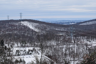
The Orange Trail ends at the Blue Trail, which I followed through the power cut, turned the sharp corner, crossed the power cut again, and then noticed another reroute of the Blue Trail! Instead of the steep, eroded pathway up, it now follows a much longer route (little less than a half mile extra) that is much gentler. Eventually, I did made it to the summit with a nice view, and then continued on.


On the Blue Dot Trail, I saw something I hadn't seen in a while - snow fleas! Lots of them, too. Some blue sky was starting to pop out once near Tripod Rock, and then I continued my way back to the Orange Trail and then onto Green.

The sun was shining, I was STARVING, and I followed my sole footprints back to the car on green. I did pass a duo near the end of my hike, but overall it was delightfully quiet. The sun felt like a lovely reward on my final way out!


Step-By-Step
- Start hike on Green Trail via Boonton Ave. Field.
- Enter woods, continue to follow Green.
- At terminus, turn left onto Orange Trail.
- At terminus, continue straight onto Blue Trail.
- At cairn, turn sharply right to continue on Blue Trail.
- Follow Blue Trail's new route via signage to the top of Pyramid Mountain.
- At summit, continue on Blue Trail.
- At jct., continue left on Blue-Dot Trail.
- Continue past Tripod Rock on Blue-Dot Trail.
- At terminus, turn right onto Orange Trail.
- At next jct., turn let onto Green Trail, return to car.


Tuesday, December 26, 2023

Pyramid Mtn. & Tripod Rock via Green/Orange (Pyramid Mountain Natural Historic Area)

Pyramid Mtn. & Tripod Rock via Green/Orange (Pyramid Mountain Natural Historic Area)

Distance: 5.03 miles
Elevation: 673 feet
Time: 1 hour, 40 mintues
Hike Type: Lollipop Loop
Hiking Challenges: 52 Hike Challenge

The Hike
Time to hike off the Christmas cookies! I had a few ideas for this day - I wanted to hit the water gap, but I did not wake up early enough to do so without insane crowds (grateful for Google's feature where it tells you how busy a certain location is in real time), so I decided to go for another classic and hit Pyramid Mountain from the Boonton Ave field, so at least part of my hike would be in solitude. It was a cloudy day, temperatures in the low 40s, I was in shorts and a long sleeve base layer (a lesson I learned after my last jaunt in the Blue Hills), and forgot my camera - classic! I was the only one in the parking lot, and got right to it!

The Green Trail was covered in packed leaves with a few washed out spots from the crazy rain storm of recent. I was very happy with my decision to take this route - I only saw one mountain biker and a few squirrels the whole stretch. I would also like to note - this was the last day I had my iPhone 8, who's camera violently shook whenever I tried to take a photo, hence the blurry photos.


Once on the Orange Trail I noticed the air smelled like a cloud. There were very small patches of blue sky peeking through the cloud cover. The temperature was nice for exercisse. I enjoyed the lovely views of the Taylortown Reservoir and passed a small amount of people, including six swans flying around the water! I was grateful for how dry the trail was (minus one wet patch).


Once Orange terminated, I continued onto Blue where I started power hiking to get past the crowds of people - most of which took the hint and let me pass without too much awkward close-hiking. The stretch of the Blue Trail from the sharp turn to the summit is a nice workout, especially while power hiking, and I enjoyed the view from the lookout.


From the summit to Tripod Rock I passed a few more handfuls of people which thankfully dissipated after I passed Tripod Rock. I admittedly was on my phone a bunch during this hike so I needed to break out the trusty power bank. The rest of my return trip was peaceful and lonely in the good way (is there a word for this?). 


Step-By-Step
- Park at Boonton Ave Field.
- Follow Green Trail along north side of the field area.
- Enter park at trail kiosk, continuing on Green.
- At terminus, turn left onto Orange Trail.
- At terminus, continue straight/left on Blue.
- At next junction, turn sharply right to conitnue on Blue.
- At next junction, turn right to continue on Blue.
- Summit Pyramid Mountain, continue on Blue. 
- At next junction, continue left onto Blue-Dot.
- At Tripod Rock, continue on Blue-Dot.
- At terminus, continue straight/right onto Orange.
- At next junction, turn left onto Green.
- Return to car.

Wednesday, July 12, 2023

Pyramid Mtn. & Tripod, Bear, Whalehead Rocks (Pyramid Mountain Natural Historic Area)

Pyramid Mtn. & Tripod, Bear, Whalehead Rocks (Pyramid Mountain Natural Historic Area)

Hike Type: Lollipop Loop 
Distance: 5.27 miles
Elevation: 735 feet
Time: 2 hours, 12 minutes
Hiking Challenges: 52 Hike Challenge


The Hike
#2 in my series "I still have energy but can't actually go for the goals that I set for myself becuase rain shut down Harriman/Bear Mountain State Parks" - I revisited Pyramid Mountain! The plan was to hit some spots I know and love, but also to hike on some trails I've never been on before. I was slightly turned off when I passed a group of 30+ children in the parking lot, but I got past the "fight or flight" and headed into the woods!


The blue trail is right off the parking lot and very well maintained/blazed. I swam through the dense, hot humidity while following the winding blazes which led to a slightly sketchy bridge that crosses a lovely stream. Here, the blue trail splits into its two forks to form its loop - I turned left. There were a few instances of dog poop on the side of the trail which was a huge bummer, but my crankiness went away when I saw the lovely view from the wide-footbeded power cut - yay! It actually reminded me slightly of that early 2000s jumpscare video with a car driving on a winding road...


Further down the trail there is an off-trail overlook also onto the powercut (at the height-of-land on the cut), and then the blue trail turns right on a relocated section to climb up the shoulder of Pyramid Mountain, passing some razz/wineberries that I wasn't feeling adventerous to snack on. The views from Pyramid Mountain are quite lovely, with a hazy NYC in the background. 


Continuing on the blue trail along the ridge of Pyramid Mountain, I enjoyed a lovely breeze, and then continued on the blue-dot trail, which was lined in some lovely fungi. I took the purple trail to the mostly overgrown Lucy's Overlook, which is a short, slightly rugged trail. I made my way down to Tripod Rock which is always neat before turning around and taking an unblazed trail down the northwest side of the mountain.


The unblazed trail appeared to be blazed in a past life, and steeply descended the mountain into a mossy floor that was a little wet with a few mosquitos. My body was telling me to drink more water and that I was probably still dehydrated from yesterday... whoops. This trail terminates at a lovely footbridge over a stream to the massive erratic named Bear Rock.


Bear Rock was a fun surprise becuase I hadn't looked at the map in a minute, and again, it was massive. On the backside you could see how it's actually two rocks, clarly split from one another who knows how long ago. Sadly, I couldn't stay too long as the bugs were ACTIVE. 

Continuing on the orange trail now, I was soon greeted with a massive bile of fresh berry-filled bear poop, which did put me on alert (I was never to see a bear, but did hear some questionable rustling in the woods). The trail alternated between dry, muddy, and comically wet, with Bear Swamp on the right. 


The orange trail turns at the junction with the white trail (with a sign warning that the white trail leaves the park) and becomes more rugged, passing over mid-sized rocks for what felt like an eternity, especially paired with the bugs. There were some loud construction sounds coming from the nearby homes, which initially spooked me. The trail then began to climb back up the shoulder of the mountain steeply with rocky footing, which definitely hurt, but it left all the bugs down low and brought back the beloved breeze!


Now up on the ridge, the orange trail meanders in a roller-coaster-like fashion past many erratics and at one point passing by some homes. The trail passes the extremities of Big Cat Swamp where there were many bullfrogs singing their silly songs, and I realized that this stretch of trail was much longer than I was emotionally ready for. 


Finally I approached my favorite part of trail in this park - the orange trail along the Tarrytown Reservoir. The trail opened up on a slab with an obstructed view and a sign pointing out that you must take the slab, as the herd path around the back has been closed (but they didn't brush it in, which is interesting). I was impressed with how much the vegetation has grown in since February (which of course makes sense) - it looked like a whole new forest!


The trail approached the reservoir which smelled strongly of lake and had dozens of dragonflies zooming about. There was a lovely breeze, and a great blue heron skirting the waterline flying away from the beast stomping towards it (me). The rest of the hike was quick and easy, taking orange back to the blue, crossing the sketchy bridge, and wiping the pools of sweat off myself back at the car. 


Step-By-Step
- Park at main parking area.
- Start hike on Blue Trail.
- After crossing stream, turn left at the split.
- At next junction, turn right to stay on Blue Trail.
- Summit Pyramid Mountain.
- At next junction, turn left onto Blue-Dot Trail.
- At next junction, veer right to stay on Blue-Dot Trail.
- At next junction, turn left to follow Purple Trail to Lucy's Overlook.
- At terminus, turn left back onto Blue-Dot Trail.
- Continue on Blue-Dot to Tripod Rock.
- Turn around at Tripod Rock.
- Turn left off of Blue-Dot Trail to unblazed Trail.
- At terminus, turn right onto Yellow Trail.
- Cross bridge to Bear Rock.
- At terminus of Yellow Trail, turn right onto Orange Trail.
- Stay on Orange Trail for a long time, until its terminus back at the Blue Trail.
- Follow Blue Trail back to car.


Tuesday, February 21, 2023

Green-Orange-Blue Loop (Pyramid Mountain Natural Historic Area)

Green-Orange-Blue Loop (Pyramid Mountain Natural Historic Area)

Hike Type: Lollipop Loop

Distance: 5.21 miles

Elevation: 699 feet
Time: 1 hour, 51 minutes

Hiking Challenges: N/A


The Hike

My final hike in New Jersey before flying to Florida to visit my dad at his new place! I had a few hours to kill in the morning, so I drove to an old favorite - Pyramid Mountain. I had hiked here for a field trip in the 2nd grade to the famous Tripod Rock, and then again with cub scouts, and a few more times as I got older and started exploring the area more. I decided to go with a loop that I know I enjoy that parallels the Tarrytown Reservoir, then climbs up Pyramid Mountain and returns via Lucy’s Overlook and Tripod Rock. I made it out the trailhead at the Boonton Avenue field just before 8:00am, and got started hiking in the cool, misty air. 


The very first stretch of the hike is along an access road which parallels multiple sports areas before continuing into the woods. The green trail is a gentle meander through the woods in view of the reservoir, passing over a few footbridges and skirting some private property. At some point in the past there was a trail that connected Pyramid Mountain with a local street in Kinnelon, and then further to the Kakeout (sp?) Reservoir, but that appears to have been since abandoned. The final stretch of the green trail is a bit steeper up a slippery rock slab, but thankfully I didn’t fall. Finally, the trail terminates at a new (new to me at least) kiosk, with the option to turn left or right to join the orange trail.


I turned left which immediately led to a nice viewpoint over the Taylortown Reservoir. There wasn’t much distance to the views due to the foggy, misty conditions, but it was still nice. The orange trail scrambles down and then slowly descends through open woods and impressive rock formations to the shoreline of the reservoir, which is where I infamously took a picture with my friend Marissa in high school, posted it on Facebook, and then my aunt commented “is that where you go to make out?” - which Marissa was not a fan of. We have not been facebook friends since. The orange trail continues to meander around the reservoir area until it turns away from the dam in a rooty area, and eventually comes to its terminus after following what appears to be a summer camp/corporate picnic area. 


Next up is the blue trail, which has clearly been rerouted since my last visit years ago. I have a vague memory of a very steep yellow trail jutting off at some point during this first stretch of blue, but I’m not entirely sure. The blue trail in this section is very gentle, and eventually passes through a power cut with a classic power cut view. Soon after the trail turns sharply right and begins to climb Pyramid Mountain, first gently up to cross the power cut again, and then steeply up to the summit area, which seems freshly manicured. There is a large cairn and two viewpoints up at the summit, both offering the same nice view. Nothing breathtaking, but lovely nonetheless. The blue trail then gently descends off the summit to a junction with the blue-dot trail, which is the next leg of my morning adventure.


The blue dot trail is lovely, slightly rugged, and very green. Lots of rhododendron and lichen… and rocks. I took the purple trail to Lucy’s Overlook, which has a lackluster view but a nice, rugged trail. Purple rejoins blue-dot, and then it leads to the classic Tripod Rock, which is a glacial erratic that is truly impressive how it manages to balance. The blue-dot trial leads away from Tripod Rock, I realize how hysterically sweaty I am for a 36-degree day, and it meanders through the ridge line until its terminus at the orange trail.


The final stretch of the hike followed the orange trail back to the junction with the green trail, trying very hard to not slip down the wet rock slab on the green trail, and questioning what the very loud sound was coming from in the distance from the direction of my car. I would later realize that my car was fine, but they were taking down multiple trees right next to my car, and they were parked along the access road that the trail follows. Instead of risking a falling limb, I walked through the baseball field before eventually making it back to my car, getting back to Mom’s house, realizing there’s no bread for grilled cheeses, and then ordering bagels instead. 


Step-by-Step

  • Park at Boonton Ave. field and start hike following green blazes.

  • Follow green blazes to terminus at the orange trail.

  • Turn left onto the orange trail.

  • Follow orange trail to terminus.

  • At terminus, continue left onto blue trail.

  • At cairn, turn right to continue on blue trail.

  • Follow blue trail to the summit area of Pyramid Mountain, then continue on.

  • At terminus of blue trail, turn left onto blue-dot trail.

  • At junction with purple trail, turn left onto purple trail to Lucy’s Overlook.

  • At terminus of purple trail, turn left to continue on blue dot trail.

  • Follow blue dot trail to its terminus, with a side trip to tripod rock.

  • At terminus, turn right onto orange trail.

  • At next junction, turn left back onto green trail to complete the loop and return to car.