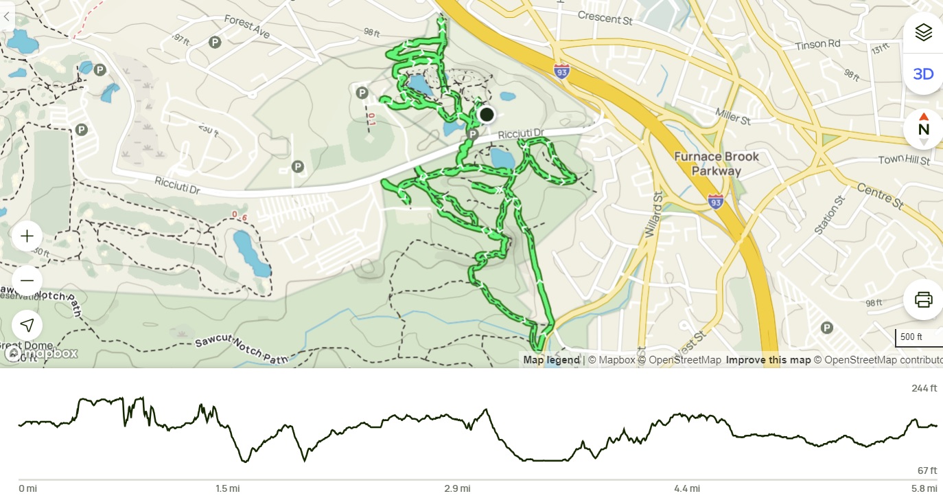
Showing posts with label Quincy Quarries Area. Show all posts

Tuesday, June 3, 2025

Great Dome, Ridge, Wood, Romari, Squamaug Notch, & Skyline Trails (Blue Hills Reservation)

Great Dome, Ridge, Wood, Romari, Squamaug Notch, & Skyline Trails (Blue Hills Reservation)

Hike Type: oo-o Loop
Distance: 5.08 miles
Elevation: 597 feet
Time: 2 hours, 18 minutes
Hiking Challenges: 52 Hike Challenge 2025, Trail Trace the Blue Hills, Blue Hills Grid

The Hike 
Sarah and I both decided we did NOT want to do a fitness hike after school, so she agreed to follow me around as I did some tracing in the Quincy and Chickatawbut areas! I had a CODE YELLOW drive, especially towards the end, but thankfully avoided any disaster. We got hiking at 4:00pm from the Chickatawbut Overlook parking area, first by following Chickatawbut Road and then following Great Dome Foot Path, where Sarah managed to roll her bad ankle twice! Boo!


We meandered down to Pine Tree Brook Path, Sassaman Path, and then Ridge Path, which brought us across Chickatawbut Road and over to the Chickatawbut Hill side of the reservation. We noticed an abundance of allegheny blackberry bushes and some baby baby blueberries! We continued over to Wood and Romari Paths, which were kind of underwhelming (as usual) and just buggy enough to be annoying. We did see FOUR frogs, though!


We slowly worked our way back to Squamaug Notch Path and decided to get some views on the Skyline Trail, which was an EXCELLENT move. Time felt slower than usual and I was mentally lagging, but following the Skyline Trail to Nahanton Hill brought me right back. The golden hour from the sun was stunning, and the views were wonderful. There were SO MANY baby blueberries, too!


We eventually made our way up and over Nahanton, down to the tower, and back to the car. A lovely afternoon!


Step-by-Step
- Park at Chickatawbut Overlook.
- Start by hiking east on Chickatawbut Road.
- At 4053, turn left and veer right onto Great Dome Foot Path.
- At 4073, turn left on Pine Tree Brook Path.
- At 4094, turn left onto Headquarters Path.
- At 4048, turn left onto Sassaman Path.
- At jct., turn right onto Ridge Path.
- At Chickatawbut Road, cross Chickatawbut Road and continue.
- At 3131, turn left onto Squamaug Notch Path.
- Before 3143, turn left onto Curve Path.
- At 3157, turn left onto Wood Path.
- At Wood Road, turn around.
- At 3174, veer left onto Romari Path.
- At 3152, turn right onto Curve Path.
- At 3143, turn right onto Squamaug Notch Path.
- At 3144, turn left onto Skyline Trail.
- At 3103, continue veering right.
- At Slide Notch Path, continue straight onto Tower Path.
- Return to car.

Monday, May 26, 2025

Cedar Rock & Pasture Run Paths, CCC Camp, Ridge Path, & Nahanton Hill (Blue Hills Reservation)

Cedar Rock & Pasture Run Paths, CCC Camp, Ridge Path, & Nahanton Hill (Blue Hills Reservation)

Hike Type: O-O Loop with Spurs
Distance: 5.32 miles
Elevation: 643 feet
Time: 1 hours, 48 minutes
Hiking Challenges: Trail Trace the Blue Hills

The Hike 
First hike in over a week! The weather had been dreadful for the past week and I had what I affectionately call "Chorus Week," where I had a field trip and an after-school concert, so it's been busy! Some friends from New Jersey came up for Memorial Day Weekend, which was wonderful, and the sun FINALLY came out once I dropped them off at the airport, so it was time to get back to the Blue Hills! The drive from Logan to the Chickatawbut Overlook was shockingly docile and easy. I ate like a KING this weekend, so I was looking forward to getting some exercise in. My only plan was to hike some trails I needed for tracing on the Quincy and maybe Chickatawbut side - really just let the wind take me! It was 61 degrees, mostly sunny, I forgot my camera at home, and just after 11:00am I began my hike!


I started by descending along the Cedar Rock Path, which smelled wonderfully of summer. The ferns have officially unfurled and small flowers created a delightful aroma. There's a good number of criss-crossing trails around Cedar Rock Path, but the correct one is always the one that feels the most correct. I continued on Pipe Line for just a second before crossing a wet spot and climbing up Pasture Run, where I saw some Witch Hazel Cone Gall Aphids accoding to the Seek app. They looked like little red cones on the broad witch hazel leafs - pretty cool!


I kept looking at the map, trying to figure out how to most effectively hike this cluster of zig-zagging trails, and eventually got overwhelemd and decided to head to the CCC Camp instead. I had hiked a full mile before seeing other people, which was a huge win for lunchtime on Memorial Day! There were some unleashed dogs on the Pipe Line which annoyed me, but I got well ahead of them. 

I turned onto Sawcut Notch Path at a sign that indicated "CCC Camp 800 Yards" and I wondered if anyone actually knows what 800 yards feels like.. (according to Google's calculations, it's 0.45 miles). The undergrowth was strong in a wet area and it looked like an old culvert had finally failed (UPDATE: Yes, I am correct. I have a photo of the culvert from March 12, 2023 where it was still mostly in-tact). 


I next hiked Minuteman Path to the border of the reservation. The recent heavy rains effectively brushed the trail, which was nice. I turned around at the state land border and continued onto CCC Trail, which is always a favorite (even if becoming a bit overgrown). The old Sassaman Path was officially marked as closed and I couldn't help but wonder about how the CCC Camp would look without all of the new growth, but I understand why they are letting it grow in.


After the height-of-land on the CCC Trail, the path descended past endless wild geranium which smelled wonderfully. I continued onto Nike Ajax and back to Sawcut Notch Paths where I did some productive work (i.e., responding to emails, tallying up the Venmo charges from the weekend, and actually responding to texts I had forgotten about), eventually crossing an older woman who was holding some of the wild geranium and said "I come here once a year to identify plants, but every year I forget which one is which!" which gave me a laugh.

I had hoped to also get the Pipe Line to Little Dome loop, but the trail was grassy and flooded - not today, satan! I began to wiggle my way back to Chickatawbut Road, and just after getting onto Indian Camp Path, I passed a pink lady slipper! My favorite flower!

The trail got grassier once on Great Dome Foot Path, which soon crossed the outflow stream from the Blue Hills Reservoir (which may or not be Pine Tree Brook proper), climbed up a steep, grassy hill, and then turned onto Pine Tree Brook Trail, which I followed all the way to Chickatawbut Road. I crossed the brook again near the road, and the final bit of trail nearest the road was flooded and required a bit of bushwhacking.

From here, I crossed Chickatawbut Road on Ridge Path, climbed up to Squamaug Notch Path, and climbed up Nahanton Hill via Endicott Path and Skyline Trail. The view was wonderful, but the crowds of people were not. I had dreamt of following Skyline to Chickatawbut, but quickly bailed. There were even a good number of people on the backside of Nahanton, which solidified my decision. 

I made my way down to Tower Path on the back side of Nahanton (which showcased a nice view toward Mt. Monadnock) and followed the path to the Tower and back to the car. It felt good to be back and it felt even better to be outside under blue skies!


Step-by-Step
- Start hike on Cedar Rock Path from Chickatawbut Overlook.
- At 4012, turn right. 
- At 4030, turn right onto Pasture Run.
- At 4052, turn left onto Chickatawbut Road.
- At 4053, turn left onto path.
- At jct., continue right onto Pasture Run.
- At split, veer right onto Sassaman Path.
- At 4048, turn right onto Pipe Line.
- At 4066, turn left onto Sawcut Notch Path.
- Before 4042, turn right onto Minuteman Path.
- At Blue Hills Reservation boundary, turn around.
- At terminus, turn right onto Sawcut Notch Path.
- At 4042, turn left onto CCC Trail.
- At 4010, turn left onto Nike Ajax Path.
- At 4009, turn around.
- At 4010, continue onto CCC Trail.
- At 4014, turn left onto Sawcut Notch Path.
- At 4011, turn around.
- At 4066, turn left onto Pipe Line.
- In 30 feet, turn around when the trail is too wet.
- At 4066, turn left onto Sawcut Notch Path.
- At 4083, turn left onto Crags Foot Path.
- At split, veer right.
- At terminus, turn right onto Indian Camp Path.
- At 4086, turn right onto path.
- At 4082, turn left onto Pleasant Trail.
- At 4085, turn right onto Indian Camp Path.
- At 4090, turn left onto Great Dome Foot Path.
- At 4073, turn left onto Pine Tree Brook Path.
- At terminus, turn left onto Ridge Path.
- Cross Chickatawbut Road.
- Continue on Ridge Path.
- At 3131, turn left onto Squamaug Notch Path.
- At next jct., turn right onto Endicott Path.
- At 3132, turn right onto Skyline Trail.
- At 3103, continue straight onto path.
- At jct., turn right to descend.
- At jct., continue onto Tower Path.
- At Chickatawbut Tower, turn right and return to car.

Friday, April 18, 2025

Chickatawbut Skyline Trail, Fox Hill, Little & Great Domes (Blue Hills Reservation)

Chickatawbut Skyline Trail, Fox Hill, Little & Great Domes (Blue Hills Reservation)

Hike Type: o-o Loop
Distance: 6.71 miles
Elevation: 758 feet
Time: 2 hours, 23 minutes
Hiking Challenges: Blue Hills Grid; Trail Trace the Blue Hills

The Hike 
Time for ANOTHER hike in the Blue Hills on ANOTHER beautiful day! It was my first day of April break and I was set on making my way over the Little and Great Domes (plus Fox Hill for some gridding). Temperatures were in the mid-50s when I started hiking in the morning and were set to climb. Originally, I had hoped to hike somewhere up north, but I NEEDED some sleep (and thank goodness I got it!). 


From the Braintree Pass Path trailhead, I started my hike along the Pipe Line just after 10:00am. I wore my waterproof boots for good measure, which paid off at the classically wet and muddy stretch. I passed a small bird's nest, scared the life out of some poor ducks, and admired the skunk cabbage that was growing in strongly. The mud started at the incline, which also featured some deer tracks. 


I made my way to the Hemlock Bound Foot Path, hiked to MA-28, and followed MA-28 for ~15 feet to the Skyline Trail, which had a normal blue but also an orange/brown blaze, which confused me. Maybe an old Great Dome Trail blaze? Not sure. 

Anyway, I followed the Skyline up the three distinct climbs up Chickatawbut Hill, which are steep and fun (and have herd paths around the steeps which I do NOT agree with). The temperature felt HOT now that I was climbing, but it was still delightful. I also included a note that I am, in fact, still mad about the fence around Chickatawbut Hill. 


I followed a faint herd path at the height-of-land to get to the true summit of Fenno Hill and continued down the well-crafted stairs up and over Kitchamakin and Nahanton Hills, the ladder of which features just beautiful views. I did notice a dad and child basically free-climbing up the rocky ledges of Nahanton which seemed wildly dangerous? To each their own, I guess... 


I was enjoying the beautiful walk across the Broken Hills when I got my first bug bite of the season followed by being charged at by a giant spider! Horrible. I also crossed paths with another large back snake - smaller than the one on Kitchamakin - but this one shook its tail to pretend it was a rattlesnake, which I did NOT like. 


Eventually, I escaped the cursed Broken Hills, crossed Wampatuck Hill, and made my way to Fox Hill. There was a vulture circling overhead, and with my luck, I was stressed, but thankfully I escaped unharmed. I descended via Fox Hill Path and began my drip to Sawcut Notch Path, where I turned onto a herd path at the height-of-land to summit Little Dome, which was LOVELY! There was a tree view of Hancock Hill and some daffodils (I think) next to a fire ring.


I retraced my steps back to Sawcut Notch Path, hiked alongside some spooky orange mud, and started on the herd path/old Great Dome Foot Path to the summit of Great Dome. The foot path was just discernable enough to follow it mostly without question, and the summit is just beautiful! It features a very unique view with Fox Hill's open forest, the Broken Hills behind it, and Hancock to the right. This summit also had daffodils and some purple flowers that I did not identify. 


I wandered around the summit for a bit, hoping to find an old blaze or foot path to continue along the old Great Dome Foot Path (Great Dome Trail?), but eventually fell short and gave up. I did see a goldfinch, though! I retraced my steps, noticed some golfers through the trees, and continued along Satcut Notch and then Short Path past a comical amount of robins.


I looked hard for any evidence of the old Great Dome Foot Path/Trail, but did see anything clear in my return... oh well. I followed the appropriately named Pleasant Trail to the Pipe Line, which started my long walk back to the car! It was wetter one near Chickatawbut Road, but overall not too bad. This was a seriously fun, unique loop!


Step-by-Step
- Park at Braintree Pass Path trailhead.
- Start hike on Braintree Pass Path.
- At 3022, continue right on Pipe Line.
- At 3013, turn right onto Hemlock Bound Foot Path.
- At terminus, turn right onto MA-28.
- At jct., turn right onto Skyline Trail.
- Cross Chickatawbut Road.
- At 4134, turn left onto path, staying left.
- At Pipe Line turn left.
- At terminus, turn right onto Fox Hill Path.
- At 4102, turn left onto Indian Camp Path.
- At 4091, turn left.
- At 4083, turn right onto Sawcut Notch Path.
- At height-of-land, hike herd path on left to Little dome, then continue on Sawcut Notch Path.
- Beofre height-of-land, hike on former Great Dome Foot Path to Great Dome on right, then continue on Sawcut Notch Path.
- At 4133, turn right onto Short Path.
- At 4124, turn right onto Crags Foot Path.
- At 4091, turn left onto Indian Camp Path.
- At 4086, turn right onto path.
- At 4082, turn right onto Pleasant Trail.
- At 4046, turn left onto Pipe Line/Headquarters Path.
- Follow Pipe Line/Headquarters Path to Chickatawbut Road.
- Cross Chickatawbut Road, follow Pipe Line/Headquarters Path back to car.


Thursday, April 17, 2025

Rattlesnake & Wampatuck Hills via St. Moritz Ponds (Blue Hills Reservation)

Rattlesnake & Wampatuck Hills via St. Moritz Ponds (Blue Hills Reservation)

Hike Type: -o-o-o Loop
Distance: 3.18 miles
Elevation: 384 feet
Time: 1 hour, 7 minutes
Hiking Challenges: Blue Hills Grid; Trail Trace the Blue Hills

The Hike 
Happy Thursday! This might be the first, if not definitely one of the first, times that I've hiked in the Blue Hills for four days in a row! What was extra great was that this was also my Friday - since it's officially April vacation! I was going to see HONK! Jr. at a middle school my friend works at that evening, so I had a little over an hour to kill in the Quincy area of the Blue Hills. It was a stunning 60 degree day (another beautiful day!) and it was fun to be back in the quarries area, where I hadn't been in at least six months.


My hike started at the eastern terminus of the Skyline Trail, hiking past some rotting pumpkins and a pile of random toys(?). I continued onto Minichiello Path on the boardwalk, which was in great condition (it was flooded last spring). Geese were honking me along from the pond as I turned onto the Firepit Path, which is a lovely path through the woods along the pond. From there, I hopped back on the Skyline Trail.


I crossed Wampatuck Road and made my way up Rattlesnake Hill, past the Sullivan Quarry. I always wonder how deep the quarry actually is, and I was surprised to see so many fish inside swimming about!


From the height-of-land on the Skyline Trail on Rattlesnake Hill, I followed a herd path on the left to the actual summit area, which looked like the former summit cairn had been partially dismantled.

I worked my way back to the Skyline Trail and ran into a person from the Crags viewpoint, where I found a person that spooked the life out of me. The descent from Crags is always horrible, rugged, and steep, but at least its short!


Continuing on, I passed a shallow pond after the Skyline Trail crosses the Pipe Line and ascended Wampatuck Hill, where I always look around for a former USGS Disc. I think I need to accept that it is no longer there... I caught a glimpse of Mt. Wachusett from the descent, and when I opened up Pokemon Go, I caught ANOTHER shiny Fuecoco! Right after, I caught a shiny event Pikachu! I guess the Blue Hills are my lucky spot for shiny Pokemon...


I started my way back along Crag Trail, the Pipe Line, and then the Quarry Trail - following green blazes for the ladder. The green blazes brought me back across Wampatuck Road and past some delightfully old trees - one of which was 200 years old! I noticed that somebody fixed the "4220" trail junciton sign (it used to read 4 20, which was objectively funny), and saw some small needle-shaped fish in the St. Moritz Ponds. The usually wet spot where the Skyline Trail traverses between the two ponds was significantly more dry than I had ever experienced - I wonder if they did work on the dam to help lower the levels? Or maybe we're just in a draught that I was unaware of? No idea, but I was soon back at the car and enjoyed some lovely tween artistry at HONK! Jr.


Step-by-Step
- Park at Shea Memorial Rink
- Start hike on Skyline Trail at 4234.
- At split, continue left on Minichiello Path.
- At jct., turn right onto Firepit Path.
- At terminus, turn left onto Skyline Trail.
- At 4134, turn right onto path.
- At 4131, turn right onto Crag Trail.
- At terminus, merge onto Water Pipe Line.
- At 4135, continue off of Pipe Line and onto path (still Crag Trail)
- At 4151, turn right onto Quarry Trail (green blazes).
- At terminus, turn right onto Skyline Trail. 
- At 4220, turn left onto path.
- At Wampatuck Road, turn around.
- At 4220, turn left onto Skyline Trial.
- Follow Skyline Trail back to car.

Saturday, January 4, 2025

Squamaug Notch, Great Cedar Swamp, Braintree Pass, & Cedar Rock Paths (Blue Hills Reservation)

Squamaug Notch, Great Cedar Swamp, Braintree Pass, & Cedar Rock Paths (Blue Hills Reservation)

Hike Type: Loop
Distance: 5.30 miles
Elevation: 443 feet
Time: 1 hour, 40 minutes
Hiking Challenges: 52 Hike Challenge 2025; Blue Hills Winter Trace (2x)

The Hike
Hike #2! I was feeling marginally better from the mystery illness so I wanted to go for a longer hike, on a colder, winder day, apparently. The plan was to wander the Chickatawbut area without climbing any of the hills. I was congested, snotty, and frigid, and I was off!


There was some avoidable ice, of the boilerplate and needle variety, on the pathway to the tower. At the tower, somebody was blowing some form of what appeared to be an indigenous horn and praying in between, so I let them have their privacy and continued along toward the Squamaug Notch Path, which I forgot is one of my favorite trails - it's just surprisingly scenic for a wooded trail. There were seasonal tree-views of Boston and the reservoir through the trees, though.


My puffy came off right at the height-of-land, and then I continued my way down to the end of the trail, making my way towards the Great Cedar Swamp via the Hemlock Path. I eventually caught up to a guy walking his dogs, but he would pick up his pace everytime I came within 20 feet, which was... fine. To stall time, I investigated the Hemlock Bound rock, which had a herd path near it leading to a nearby business. 


I scooted around I-93 through the broken fence, and then turned uphill to the Braintree Pass Path to break up with the man I had been inadvertently stalking. My heart rate got higher than I had wanted it to, being sick and all, but it was fine. The Braintree Pass Path was beautiful as always, and one of the longer continual paths in the reservation. 


Near Chickatawbut Road, I turned onto Headquarters Path, carefully crossed, and continued along the Headquarters Path/Pipe Line. The trail quality alternated between dry, wet, and icy, but all avoidable. My last stop was the Cedar Rock Path back to the car, where I officially crossed paths with the first person of the day!


Step-By-Step
- Park at Chickatawbut Overlook.
- Hike up to tower, turn left onto Tower Path.
- At terminus, turn left onto Slide Notch Path.
- At terminus, turn right onto Squamaug Notch Path.
- At 3163, turn right onto Bouncing Brook Path.
- At 3151, turn left onto Hemlock Path. 
- At terminus, continue right onto Laurel Path.
- Soon after, turn left onto Braintree Pass Path.
- At 3024, turn right onto Headquarters Path.
- Cross Chickatawbut Road, continue on Headquarters Path.
- At 4012, turn right onto Cedar Rock Path.
- Return to car.


Wednesday, March 6, 2024

St. Moritz to Furnace Brook Trail (Blue Hills Reservation)

St. Moritz to Furnace Brook Trail (Blue Hills Reservation)

Hike Type: Lollipop Loop 
Distance: 4.54 miles
Elevation: 348 feet
Time: 1 hour, 37 minutes 
Hiking Challenges: 52 Hike Challenge; Blue Hills Winter Trace

The Hike
The COVID Chronicles: Episode 2! Thankfully, my body is used to waking up early, so these morning hikes weren't a chore. Another rainy day in the mid 40s. I was starting to feel more congested and boogery-er, but still okay enough to go for a walk in the woods. I was on foot just before 7:30am, following Willard Street to the north side of the Shea Rink, and soon enough I was back in the woods.

There were a great amount of birds around the St. Moritz Ponds, notably some Canadian Geese and a bunch of Ring-Necked Ducks! I enjoyed watching the ducks swim and dive as I brought out my zoom lens.


"How to identify:
    - Medium-sized duck with a peaked head. Both sexes have a gray bill with a white band and a black tip.
    - Males have a glossy black head, chest, and back with grey sides. Yellow eyes.
    - Females are brownish birds with a grey face and throat. Look for a bit of white around and behind their dark eyes.

        In truth, the Ring-necked Duck has a terrible name for identification purposes. You would think there would be an obvious ring around their neck, but you would be mistaken! The so-called ring on their black necks is such a pale brown that it’s nearly impossible to spot from any distance.
        Unlike most other diving ducks, these birds tend to inhabit and visit SHALLOW ponds and wetlands in Massachusetts. During the breeding season, you will usually only find two of them together, but in winter, they gather in flocks that number into the thousands of birds!
        They are one of the most likely ducks to eat leftover shotgun pellets, making them susceptible to lead poisoning. Lead shot was banned in 1991, which has helped their population numbers, but some old ammo still remains in wetlands across Massachusetts." (from Bird Watching HQ)

Thankfully, the ponds and trails were not as flooded as they were the last time I was over here. There were, however, an impressive abundance of chipmunks! I enjoyed my stroll along the Fire Pit Path, and noticed some possible beaver activity? Futher along, I imagined how different the area would have looked with the ski jump still intact.


My body was definitely feeling tired but I did not feel nearly as sick as last time I had COVID, almost two years ago. There was some running water between junctions 53 and 55, and I really enjoyed the winding trail between 20 and 42. 

Once back at the ponds, I admired the ducks for a bit longer and saw the first and only human of the day - again at a good, safe distance. The ducks were still around - yay! 


One final bit of excitement - about 30 feet from the Skyline terminus at the Shea Rink parking lot I saw someone, either setting up or backing up, a camping setup just off-trail. He had a wagon and everything, and I truly could not tell what the goal was here, and I also could not tell if he was doing this out of necessity or for hobby. Either way wishing him the best!

Step-By-Step
- Park at Shea Memorial Rink.
- Turn left onto Willard Street.
- Turn left onto woods at granite sign "St. Moritz Ponds."
- Follow path, at junction continue onto Winter Carnival Path.
- At terminus, turn right onto Minichiello Path (green dot).
- At 4205, turn right onto Pipe Line.
- At 4220, turn right onto Skyline Trail.
- Soon after, turn right onto Firepit Path.
- At terminus, turn right onto Minichiello Path (green dot). 
- At 4205, continue striaght onto Ski Jump Path.
- At terminus, turn left onto Murphy Path.
- At next junction, turn left onto Obbatinewat Path.
- At terminus, turn right onto Pipe Line (green dot).
- Cross Wampatuck Road.
- Continue on Pipe Line at 4166 (green dot). 
- At 4155, veer left onto Indian Camp Path (green dot).
- Before 4135, turn sharply right onto Crag Trail.
- At 4153, turn left onto Crags Foot Path. 
- Hike both end spurs, turn around.
- At 4155, turn right back onto Indian Camp Path (green dot).
- At 4120, turn right onto Furnace Brook Path.
- At 4142, turn right onto Crags Foot Path (green dot). 
- At unsigned junction, turn right onto unnamed path.
- At terminus at Skyline Trail, turn around.
- At terminus, turn right back onto Crags Foot Path (green dot).
- At 4174, turn right onto Skyline Trail.
- At next junction, turn left onto unnamed path.
- At terminus, turn right onto Shawmut Path.
- At terminus, turn around.
- At terminus, turn left onto green-dot trail (labeled as Crags Foot Path on 2020 map, but Quarry Path on previous ones).
- At 4148, turn around.
- Cross Wampatuck Road. 
- Continue on green-dot trail.
- At terminus, turn right onto Skyline Trail.
- Follow Skyline Trail back to car.


Saturday, January 27, 2024

Full Quincy Quarries (Blue Hills Reservation)

Full Quincy Quarries (Blue Hills Reservation)

Distance: 6.14 miles
Elevation: 525 feet
Time: 2 hours, 21 minutes
Hike Type: Messy Loop
Hiking Challenges: 125-Mile Club (2nd Time); Blue Hills Winter Trace

The Hike
Okay. It was TIME. I was going to conquer the Quincy Quarries! Last time I attempted this area, I got very overwhelmed and was simply not having fun anymore, so I cut my journey short, BUT I did get very close to finally connecting the dots. It was 35 degrees out, misty air, and I was going in determined, but with an open mind. 

PART 1: THE UPPER QUARRIES
I started my adventure hiking the trail to the pinnacle of the Granite Railway, all while admiring how vibrant the graffiti looked on the wet rocks. I also admired how carefully I was walking, while admiring how vibrant the graffiti looked on the wet, slippery rocks. I was going to do everything on this side twice, to make sure I got everything I needed for the 125-Mile Challenge and AMC's Blue Hills Winter Trace. 


Afterwards, I wiggled my way toward the Little Granite Railway Quarry and the ballfields. The trails here were really pretty, but I just wish there were intersection markers or SOMETHING to help navigate. At the terminus of the trail with the ballfield parking, there is a mattress that's been there for at least two years now - at least that's a constant! On the inner trail along the Little Granite Railway Quarry there are some neat overlooks, but the ground was VERY mushy and slippery, so I did not tempt fate. I hiked this section one and a half times, and planned to do a smaller second lap.


Continuing on, I made my way to the west side of the Little Granite Railway Quarry, which had more interesting views, and I very carefully worked my way onto what I hoped was the trail that leads to 4229. It turns out, there are roughly three parallel trails that head in this direction - I was on the uppermost, which skirts the base of the granite wall of the Little Granite Railway Quarry.


Next, I skirted along the landfill of the Granite Railway Quarry, which was partially flooded, but bridged. The water was partially frozen and looked horribly polluted. From here, I completed my faster, second lap.


I then descended to hike the Granite Railway Incline, awkwardly passing the same person numerous times. I was HORRIFIED to then find the 4229 intersection marker not where I thought it was supposed to be. Did I hike the wrong trail?? [EDIT: I mentioned this on the 125-Mile Club Facebook group, and Bob Vogel confirmed that it was misplaced and the first route I took was correct - yay!]. This trail went through old fenceposts and followed a stream, but the trail quickly fizzled out at the site of some old, rusted, abandoned cars. An old road/railbed emerged after that, but also fizzled out. I eventually connected to the middle of the three parallel trails, so if anything, at least I'm hiking everything!


I did this loop again and then headed back toward the parking area - the northern quarries were officially complete! I am still curious if the 4229 sign is misplaced, but I felt very accomplished nonetheless!


PART 2: THE LOWER QUARRIES
Now things were about to get interesting! I crossed Ricciuti Drive, entered the woods just west of the parking area, and stared by hiking the western side of things. I needed all of this area for both maps, so there was A LOT of backtracking. I meandered to the western terminus, hit the trails near 4238 and then... then I decided I was going to go for it. I was so close to connecting the dots last time, I had a weird, feral determination to do it all!

I followed the Quarries Foot Path  and the side trails to the area I call the "parking lot" - three-ish granite rectangular prisms that one would usually find in a parking lot, heading a party area filled with broken glass and crushed cans. From there, I slowly followed what I thought could have been the trail, cross-referencing AllTrails, until I saw it down below - the Quarries Foot Path I had been on before! I connected the dots!!! It was such a thrill, even if I was cranky about it. I sat-and-scootched down a lichen-covered granite slab, and gleefully hiked down to 4223.


From 4223, I went over the Bunker Hill Lane and hiked back in. Thankfully I had already done the silly rock scramble that doesn't even have a trail, so now I only had to connect the dots to what I had already done. I did some back-and-forths around 4236, made my way back to 4238, hiked past Berry's Quarry, which had a strange man doing... something, and then made my way into the meadow west of 4236, which had a collapsed tent and was partially flooded... interesting.


Finally, I hiked the random loop on the east side of this area, passed the man at Berry's Quarry, who was now lighting a campfire? And made my way back to the parking lot! Quincy Quarries have officially been conquered!! I am equally proud, excited, and relieved. Now I don't have to go back for a long time, when I'll get to do it all again.


Step-by-Step
I truly tried to type this out, but with the lack of intersection numbers/trail names, it immediately became too confusing. I did the upper section twice, the section just south of Riccuiti Drive twice, and then the lower section once. It was a journey!

THE GRANITE RAILWAY
The Granite Railway, originally built to carry stone quarried for the Bunker Hill Monument was among America's first railroads. The Granite Railway Inclined Plane was a remarkable feat of engineering.

1830
When the Bunker Hill Monument Association did now renew the contract with the Granite Railway Company to haul stone from their quarry in the West District the Granite Railway Company opened their own quarry here at Pine Hill Ledge. Gridley Bryant designed and built the Inclined Plane to transport granite down from the ledge to the existing railway that ran to it's wharf at the Neponset River.
        Rendering of the Inclined Plane railway by local artist Ruth Haderski shows the Inclined Plane as it may have appeared in 1830 based on Gridley Bryant's memoirs and the remains we see today. The following is a letter from Gridley Bryant's memoirs written to a friend describing the Inclined Plane. 
        "The Inclined Plane was three hundred and fifteen feet long, at an angle of about fifteen degrees. It had an endless chain, to which the cars were attached in ascending or descending. At teh head of this inclined plane I constructed a swing platform to receive the loaded cars as they came from the quarry. This platform was balanced by weights, and had gearing attached to it in such a manner that it would always return (after having dumped to a horizontal position, being firmly supported on the periphery of an eccentric cam. When the cars were out on the platform there was danger of them running over, and I constructed a self-acting guard, that would rise above the surface of the rail upon the platform as it rose from its connection with the inclined plane, or receded out of the way when the loaded car passed on the track; the weight of the car depressing the platform as it was lowered down. I also constructed a turn - table at the foot of the quarry, which is still in use (1859) as originally constructed. The railroad was continued at different grades around the quarry, the highest part of which was ninety-three feet above the general level; on the top of this was erected an obelisk or momument forty-five feet high."

1890
After the Granite Railway Company sold the railway right of way from West Quincy to the Neponset River to the Old Colony Railroad Company, standard gauge rails were laid over the original Inclined Plane. The quarry operation now could use standard gauge rail cars to transport granite from the quarry to its cutting sheds and for shipment by steam locomotive to any destination in the country. The endless chain system was still being used to control the cars in their ascent and descent from the quarry.

1920
In 1919 the Granite Railway Company upgraded the Inclined Plane again so that motor trucks could now be used in transporting granite from their quarry to their stone sheds at the base. Channel iron rails were placed over the original railbed and motor trucks were assisted in descent by a cable winch at the top of the inclined plane.

EXCAVATION
A section of the original 1826 Granite Railway was excavated in 1957 by archeologist Richard Muzzrole during the construction of the Southeast Expressway. Over three miles of the original railway was excavated and used for fill in the construction of the expressway. The expressway now follows the approximate route of the Granite Railway as it ran to the Neponset River. The archeological excavation shows the original stone foundation and the granite sleepers minus the wooden rails and the strap iron that was attached to the top of the rain. In the photo to the left can be seen the protruding wooden sleepers of the Old Colony and New York New Haven and Hartford Railroad tracks that were laid over the original 1826 railway. The 1826 railway originated at the Bunker Hill Quarry located about one mile southwest of here and terminated at the wharf at Gulliver's Creek and Neponset River. The railway was abandoned in 1829 when the Bunker Hill Monument Association did not renew it's contract with the Granite Railway Company to haul stone for the monument. WIth the loss of the contract the Granite Railway purchased the ledge at Pine Hill and started quarrying stone. To move the granite down from the ledge to their railway level, Gridley Bryant designed the Inclined Plane rail system and the railcars to transport the granite to the base of the incline plane. Gridley Bryant also designed a turn table located on the 1826 railway that is buried some where beneath where you are standing. 

THOMAS HANDASYD PERKINS
PRESIDENT GRANITE RAILWAY COMPANY
Colonel Thomas Handasyd Perkins was born December 15, 1764, one of 10 children of James and Elizabeth Perkins. At the age of 15 he began working in the shipping business and in 1785 when he turned 21 he launched his business career as a merchant and financier. In 1785, when China opened the port of Canton to foreign businesses, Perkins was one of the first Boston merchants to engage in the Chila trade. Perkins was the driving force in the building of the Bunker Hill Monument and the building of the Granite Railway. He served as president of the Granite Railway Company from its establishment in 1826 until 1834. In later years, Perkins became a philanthropist to many organizations through out Boston, one of which was the Perkins School for the Blind. Perkins died on January 11, 1854.

GRIDLEY BRYANT
ENGINEER AND BUILDER
Gridley Bryant was born on August 26, 1789 in Scituate, Massachusetts. Bryant's opportunities for schooling were limited, amounting to only a few months in each year in a common country school in Scituate. At the age of 15, Bryant was apprenticed to a prominent builder in Boston. At 21 he commenced business as a builder on his own. Bryant was a self-taught engineer. He always had a great desire for books, especially those of mechanics. His skills, industry and energy secured many important contracts with the United States government. Bryant's early inventions include the portable derrick, four and eight wheel rail cars, railway turntables and many types of railway switches. Bryant never patented any of his inventions, stating "I have abandoned to the public all my inventions for the public good." Gridley Bryant died on June 13, 1867 at the age of 77.

RAILCAR
A cross section drawing by archeologist Richard Mozzrole of the original 1826 railway and railcar positioned on the rails showing details of the construction of the roadbed. Two three feet deep trenches were dug about six feet apart and stones were placed in the trenches to make a dry wall foundation. Granite sleepers were placed across the two walls every eight feet, the entire length of the railway. Pine rails eight inches by six inches by sixteen feet long were fastened to the granite sleepers with iron rods. The rods were used at the joins to keep the rails from twisting out of alignment. A two inch by four inch oak rail was nailed to the pine rail with spikes. An iron strap ran two and one half inches wide by three disteenths of an inch thick was nailed with spikes to the oak rail. The total length of the Granite Railway was about three and one half miles long from the Bunker Hill Quarry to the Granite Railway ____ at Gullivers Creek at the Neponset River. The guage of the railway was five feet and between the rails was loose dirt for the horses to walk on. The wooden rails did not last due to the heavy loads and were replaced with granite rails around 1829. The iron strap rails were salvaged from teh wooden rails and reused on the granite rails.

Tuesday, December 12, 2023

Quarries Pipe Line, Crags, Southern Quarries (Blue Hills Reservation)

Quarries Pipe Line, Crags, Southern Quarries (Blue Hills Reservation)

Distance: 0.71 miles // 5.61 miles
Elevation: 29 feet // 531 feet
Time: 15 minutes // 2 hours, 5 minutes
Hike Type: Redlining Loop
Hiking Challenges: 125 Mile Challenge (2x)

The Hike (Part 1)
My first mental health day of the year, and BOY did I need it! Temperatures were in the mid-30s and I went to the Blue Hills with a relatively open plan to hit the St. Moritz Ponds the remaining Quincy trails, and the wild quarries area. The sun was shining, and off I went! 


I started by hitting the bit of trail that terminates north of the rink, which was drier than expected and passed an abandoned ballfield (which is the second abandoned ballfield in this reservation). The junction between the two ponds was WET WET and basically impassible, which was a bummer, but made sense after all the rain. I hike the other area trails heading toward 4205, until I saw that the footbridge there was also flooded out. Instead of suffer through, I decided I'd finish this side of St. Moritz, then drive over to Wampatuck Road and continue my journey with a comical game of connect-the-dots. 


The Hike (Part 2)
After a quick drive, I was back in action! I continued where the Skyline Trail enters the St. Moritz area, hiking the network of trails there. The skies were still beautiful and I realized if I needed to take off my fleece (I would) that I would look like a blueberry... whoops! I've never had to pay attention to a map so closely now that my original plan had flopped and I was truly winging it (happy to report from the future that I did not accidentally orphan any trails!). There was a nice footbridge along the Firepit path, then a spooky cage (which I believe is for the water pipeline), and then a firepit - how appropriate! 


I continued my wiggling and landed up at the top of the hill above 4205 where there were some concrete foundations - I wonder if this is where the old ski jump used to be? [EDIT: According to the Friends of Blue Hills website, I am right!]. It was getting too warm for a fleece but too cold for a t-shirt, so I made a note to always use a long-sleeve this time of year just to cover the elbows. 


With my sweaty back in fully glory, I continued across Wampatuck Road to get the sections of trail I still needed over there. I love how stick season shows how rugged the terrain is over here. Trails were generally dry... except for when they weren't. I missed a turn on the Pipe Line and hiked up a well-cascading stream at 4153, which also reminds me I really need to get waterproof, uninsulated boots for wet seasons. 

The trail was short and steep up to the crags, and then I meandered my way over to the map-less Babel Rock, which provided a surprisingly nice view of the ponds. I made my way to the official Quarries Foot Path and whispered a hail mary to myself... I've only had rough luck over here before. I did remember reading that DCR planned to blaze the foot path, but it appears that has not happened yet. 


The area where the DCR map says "Quarries Foot" was blazed with orange flagging tape, which was a godsend, and the trail on the northern side of it was only recognizable for the first half. I saw a few people in the distance and fought to avoid them - I was not emotionally ready to say hellos to strangers who were likely struggling to find the trail too, and eventually threw in the towel once I made it to a the boulder wall the leads down to Bunker Hill Lane. I was happy that I began to connect some more dots of the area, but I was getting frustrated, and a mental health day is no time to feel frustration. I will also add that the litter in the area is TRULY impressive... how often do how many people party out here?


I made my way out via Bunker Hill Lane and then followed the sidewalk along Wampatuck Road on the St. Moritz side and noticed that the ponds were flowing over the spillway, which also made sense. I made my way back to my car, and now really only have 2-4 hikes left on my 125-mile club 2nd time patch! The rest of the quarries, Brookwood, the Braintree Triangle, and of course, the Ponkapoag Boardwalk.


Step-By-Step (Part 1)
- Park at Shea Rink.
- Start hike by turning left onto Willard St.
- After the rink, turn left into the woods onto trail (concrete marker: St. Moritz Ponds).
- At Skyline Trial, hike a few feet toward 4220, but turn around since its flooded.
- Follow Skyline Trail to Minichiello Path, then turn around.
- Turn left onto Winter Carnival Path.
- At terminus, turn right onto Minichiello Path (green dot).
- At flooded trail, turn around. 
- At terminus, continue right onto Skyline Trail to return to car.

Step-By-Step (Part 2)
- Park at 4214 on Wampatuck Road. 
- Cross road to hike western side of St. Moritz Ponds.
- At 4220, turn left onto trail.
- At road, turn around.
- At 4220, continue straight-ish to continue on Water Pipe Line.
- At next jct., turn sharply right onto Murphy Path.
- At 4220, turn right onto Skyline Trail.
- Connect to the flooded section, turn around.
- Before 4220, turn left onto Firepit Path.
- At terminus, turn left onto Water Pipe Line.
- At 4205, turn left onto Minichiello Path (green dot).
- At flooded section, turn around. 
- At 4205, turn right onto Water Pipe Line (green dot).
- At next jct., turn sharply left onto Murphy Path.
- At next jct., turn left onto Ski Jump Path.
- At 4205, turn right onto Water Pipe Line (green dot).
- At 4202, turn right onto Murphy Path.
- At jct. with Ski Jump Path, turn around. 
- At next jct., turn left onto Obbatinewat Path.
- At terminus, turn right onto Water Pipe Line (green dot).
- Follow Water Pipe Line (green dot) to Wampatuck Road.
- Cross Wampatuck Road.
- Continue hike on Indian Camp Path (green dot). 
- Just before 4135, turn sharply right onto Crag Trail.
- At 4153, turn right onto trail (labeled as Crags Foot Path on FBH, but not DCR Map).
- Just before 4155, turn left onto Skyline Trail.
- In col between Crags and Rattlesnake Hill, turn left onto trail.
- At terminus, turn right onto Green-Dot (labeled as either Crags Footpath or Quarry Trail). 
- Before 4151, turn left onto small spur.
- At terminus, turn right onto trail.
- At 4151, turn right onto Green-Dot.
- At 4174, turn right onto Skyline Trail.
- At next jct., turn left onto trail.
- At terminus, turn right onto Shawmut Trail.
- At Wampatauck Road, turn around.
- At terminus, turn right onto Quarries Trail (green dot).
- Cross Wampatuck Road.
- Continue on Quarries Trail (green dot). 
- At terminus, turn left onto Skyline Trail.
- Cross Wampatuck Road again, say hello to car, reenter woods, and turn right onto unmapped trail over Babel Rock.
- At 4223, turn left onto Quarries Foot Path.
- Do your absolute best to hike as many trails as possible in the quarries area before giving up, scrambling down some granite blocks, and landing at 4235.
- At 4235, exit woods and walk along Bunker Hill Lane.
- Turn right onto Wampatuck Road. 
- Follow sidewalk back to car.