Showing posts with label New Hampshire Fire Tower Quest. Show all posts

Friday, February 21, 2025

Oak Hill Fire Tower via Sharker Road(Oak Hill City Forest)

Oak Hill Fire Tower (Oak Hill City Forest)

Hike Type: Out and Back
Distance: 3.97 miles
Elevation: 663 feet
Time: 1 hour, 37 minutes (1 hour, 28 minutes moving)
Hiking Challenges: New Hampshire Fire Tower Quest

The Hike
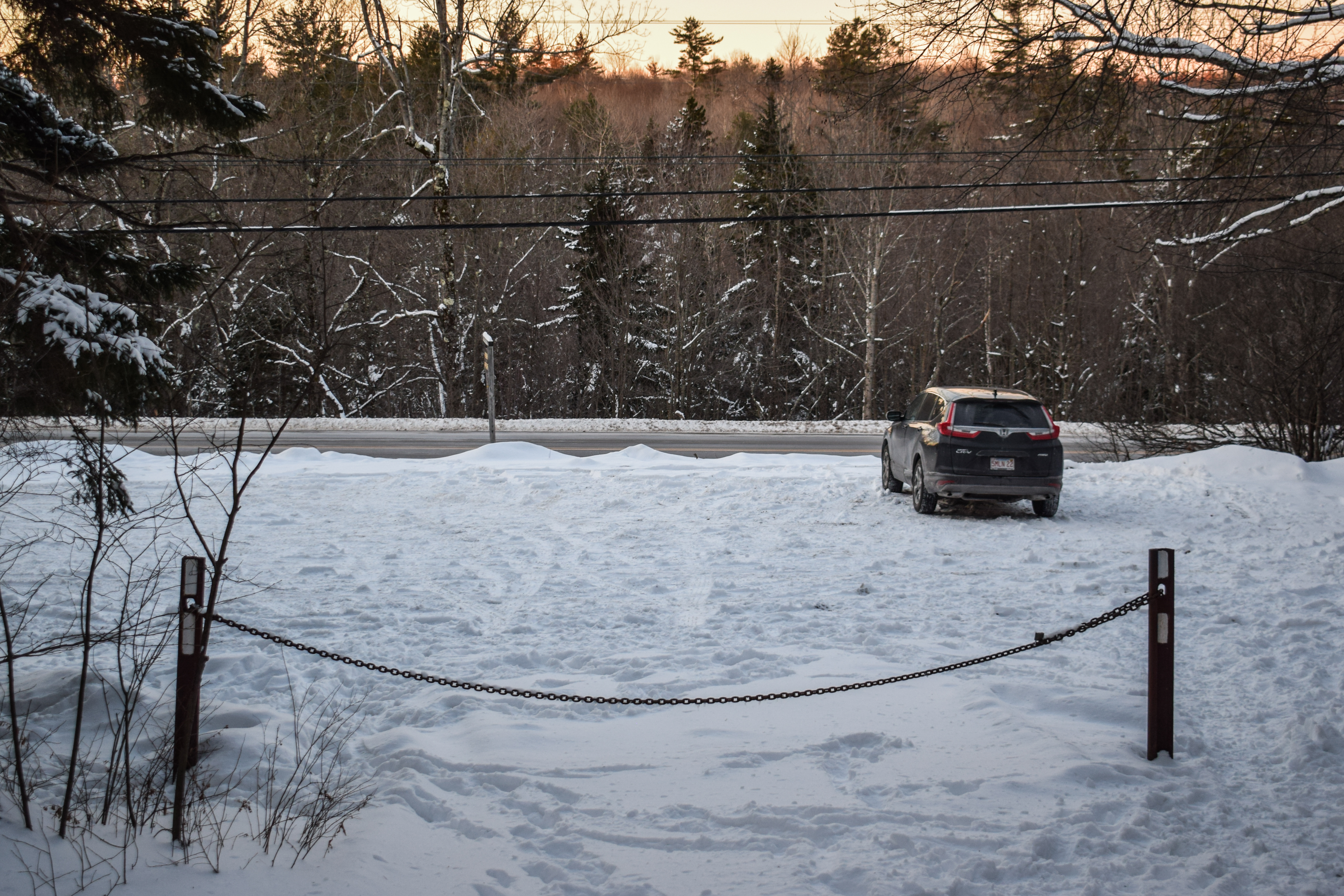
Vacation was technically over but school break was still going strong! After tweaking my knee doing something on Wednesday at Saddleback, I took my mandatory day of rest on Thursday. Now it was Friday, and it was time to get back into it! The end-plan for the day was to meet Emma at Cochran's Ski Area in Richmond, VT for some rope-towed night skiing (for $5), so I backwards-planned my day to start with an early morning hike, continuing to finish up the New Hamphire Fire Tower Quest list (you get the patch for 5 towers, but I want to finish the list still). My alarm went off just before 5:00am and it was a STRUGGLE to get up. Thankfully, I had an easy drive to Hooksett with a successful christening of the bathroom. I got two stuffed hash browns for first breakfast, and a sandwich for second breakfast that I would eat after my hike. I made it to the Oak Hill City Forest parking lot on Shaker Road at 6:45am and was delighted to see 1) a plowed lot and 2) not a single other car. Skies were overcast with a breeze and it was 19 degrees out. I brought snowshoes but the trail looked well-packed, so I made the decision to hike it in just my spikes. 


The trail starts at a kiosk and follows yellow blazes the whole way. The snow was a little softer than expected, and in hindsight it would have been good to practice hiking in snowshoes, but I was fine. The wind was causing the trees to do some spooky creaking and I was gleefully following many deer tracks as the trail meandered through the woods, intersecting with many other trails (all blazed in blue, red, or yellow, and were mostly well-signed). My nano puff came off at 0.25 miles and my fleece came off at 0.5 miles. I noticed tracks on these intersecting trails and wondered if they could be used to make a loop (or partial loop), but they were significantly less-traveled and would have required snow shoes (I should have brought them...). 


The Tower Trail skirted a semi-recently-logged area that had tree views to either Kearsarge South or Cardigan (not sure which one, I'm guessing Kearsarge) and MANY private property signs. The trail got choppier here and continued to be less-packed as it entered a denser forest, crossing a couple of bridges. 


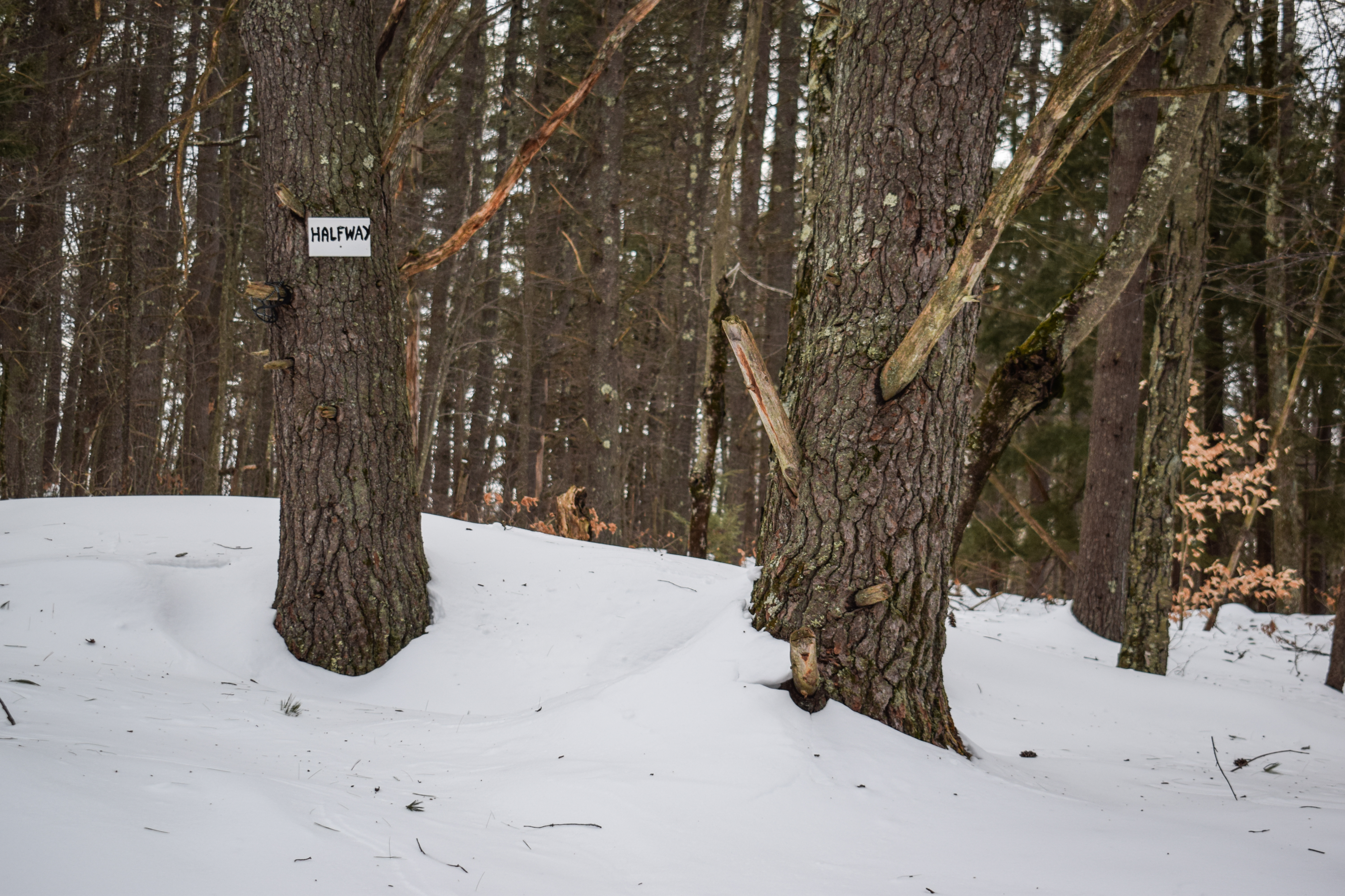
Right at the one-mile mark there was a "1/2 way" sign, and the Tower Trail intersected many other criss-crossing trails, but now most weren't broken out. It was relatively flat in this area, and I was starting to get ready for some uphill as I was getting chilly. The trail eventually came to a sharp turn at a granite marker that marked the Concord/Ludon town line, and then the trail followed a power cut for a final push up to the tower. 


The final push was a bit more moderate, which was welcomed at this point. The snow here really could have used snowshoes, as the firm monorail was about 4" wide (I only postholed once, though!). Up top, there was an old cabin, an abandoned RV, a few communication towers, some form of old machinery, and of course, the fire tower! The climb, similar to other NH towers, was steep and narrow, but not nearly as sketchy as some others. The view was a little grown-in, but I could see Monadnock, Kearsarge South, and Cardigan, which was super fun! It was 15 degrees up here with 15 to 20 mile per hour winds (I got a new anemometer! I also wrote my name, address, and phone number on this one...). I opted for no hot chocolate or break, as I just wanted to keep moving and stay warm. I also hit the two-mile mark at the top of the tower!

'

Mt. Monadnock.

Mt. Cardigan (Possibly)

Mt. Kearsarge (Likely)

I postholed once again going down, but still only once! Some blue skies were beginning to pop out, and the rest of my return trip was nice and easy. This was a great spot to explore just off the highway, and I'd be curious to wander around some of the other trails in the forest! Now, though, it was time for a quick change and a drive to Whaleback Mountain for some skiing!


Step-by-Step
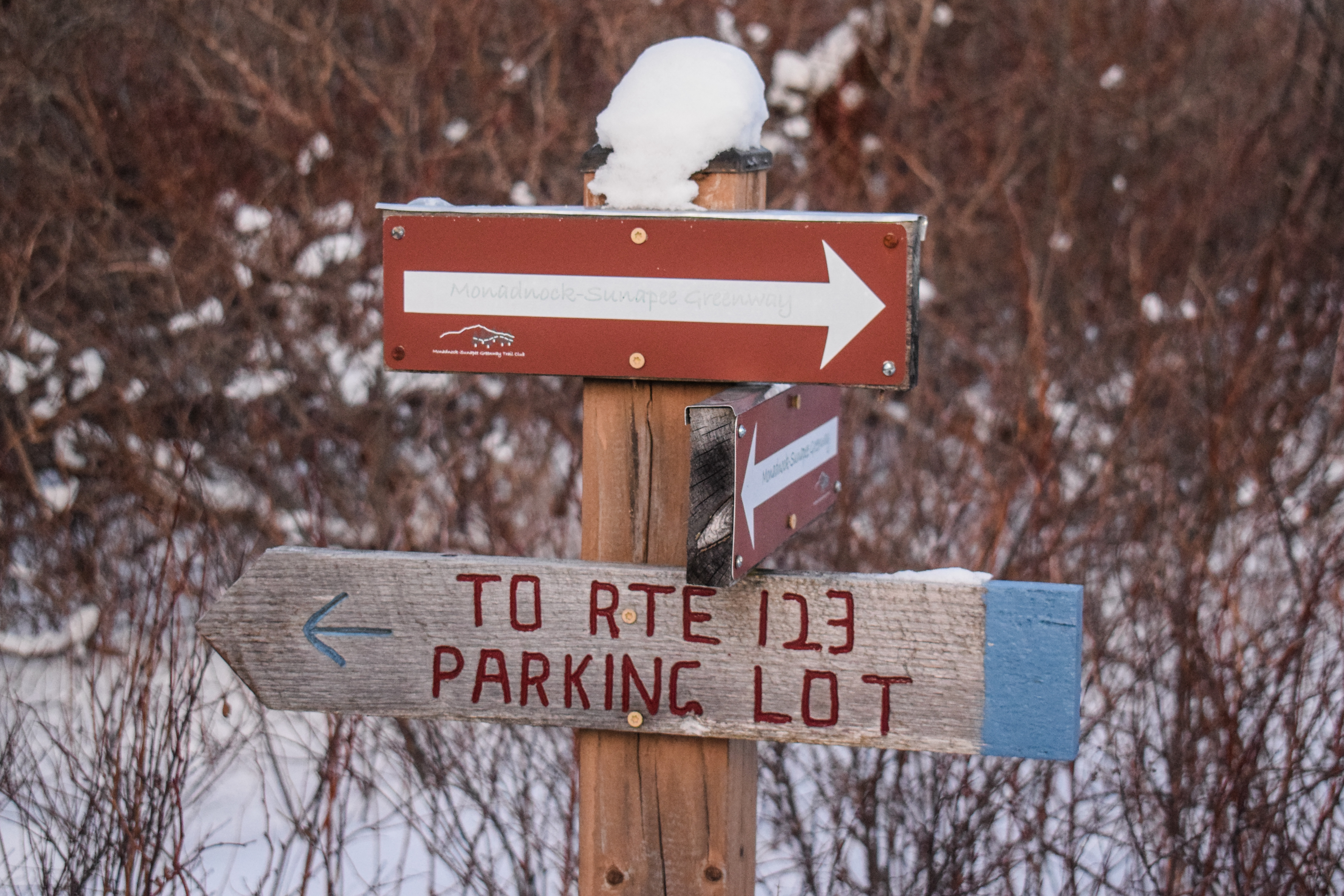
- Park at Oak Hill City Forest trailhead on Shaker Road.
- Hike to Fire Tower out-and-back on yellow-blazed trail.


"Oak Hill (In Loudon; 941 ft.)" from Southern New Hampshire Trail Guide, 5th Ed. (2021)
Oak Hill is a long ridge running east and west in Loudon and Concord. A fire tower on the wooded summit was refurbished in 2019 and offers pleasant views of the surrounding countryside and hills. Other outlooks lie lower on the mountain.

"Tower Trail" from Southern New Hampshire Trail Guide, 5th Ed. (2021)
        This yellow-blazed trail is the most direct route to the summit and fire tower from the main Shaker Rd. trailhead and also serves as a trunkline trail where several other trails branch off, making various loop hikes possible. Grades are generally easy the whole way and footing is mostly good aside from a few rocky sections. The immediate area around the summit has been impacted by logging but the trail itself is only slightly affected.
        Tower Trail leaves the parking area at a kiosk and branch of Concord's Little Free Public Library and ascends easily along a wide path to a junction at 0.2 mi. where blue-blazed Lower Trail diverges right for the Vista Way trailhead. Tower Trail bears left, immediately passes the closed former section of Ledges Trail on the right, then in 25 yd. passes a junction on the right with the current route of that red-blazed trail. At 0.5 mi. Tower Trail passes a junction on the right with red-blazed Upper Trail, which leads to the scenic vista and Oak Hill Rd. trailhead. It ascends easily, levels as it passes north of Potter Ridge, then descends to a four-way junction at 0.9 mi. where red-blazed Dancing Bear Trail leaves left (turn left onto this trail to reach the Swope Slope Vista) and blue-blazed Potter Ridge Trail leaves right.
        Tower Trail continues traight ahead and footing becomes rockier. At 1.2 mi. it passes through a lower four-way junction with the blue-blazed Krupa Loop, climbs easily over an unnamed 775 ft. bump, then descends to an upper four-way junction with Krupe Loop at 1.3 mi. Tower Trail continues an easy ascent, with a few minor ups and downs, and reaches an old stone wall at 1.7 mi. which, along with an engraved granite post on left, marks the boundary between Concord and Loudon. Here, red-blazed Ron's Way departs right.
        Tower Trail passes through the wall, turns sharply left and follows a power-line corridor at easy to moderate grades. At 1.9 mi. the fire tower comes into views as the trail makes the final ascent to the summit. The trail crosses two newer skid roads, jogging left then right at the second one, and emerges onto the broad summit clearing at 2.0 mi. When leaving the summit, Tower Trail diverges right at a fork (sign: "Tower Trail") where Oak Hill Summit Rd. bears left by the communications tower.

"History of the Oak Hill City Forest" from Trailhead Kiosk
The bedrock of what is now called Oak Hill (elev. 980 feet) formed 410 to 365 million of years ago in the late Devonian period. It consists of a rock type called Concord Granite and is part of the same rock formation that is quarried in Concord on the west side of the Merrimack River. Oak Hill came into being when the softer rock that had encompassed the granite slowly eroded away. Part of the granite formation can be observed on the Ledges Trail. The most recent geologic event that helped shape Oak Hill was the ice age. When the glacier receded about 12,000 years ago, it deposited the soil and the boulders presently found on the hill.
        Settlers first moved into the Concord area in the early to mid 1700's. They probably found Oak Hill covered by a forest of red oak, white oak, American chestnut, and a scattering of hemlock, red maple, black birch, and hickory mixed in. Most of the forest was cleared in the mid to late 1700's for agriculture. Many of the trees that were cut down were burned to create charcoal that was used in area mills and forges. The Tower Trail crosses directly over an old charcoal pit which is located about halfway between the trail's intersections with the Upper Trail and the Dancing Bear Trail. Old deeds referenced that some of the chestnut groves were left standing as the chestnuts provided nutritious food for both humans and livestock.
        Due to the steepness and rockiness of the soil, most of the hill was only suitable for pasture. As a result, only one farmstead can be found on the City Forest as there was not enough productive cropland to support more than one family. Stone walls and rock piles tent to mark the areas used for growing crops. Those areas can be found along the Tower Trail between the northern trailhead and the Ledges Trail turn-off, and in the area along Skaker Road immediately south of the farmstead site at the southern trailhead. A small amount of granite was quarried from the hill during the colonial era. Some large boulders were split along the west side of the Lower Trail just south of the footbridge and the bedrock itself was quarried near the hill's summit on the Loudon Town line. Due to poor soil conditions, most of the pasture land was abandoned in the mid to late 1800's and quickly grew in with a mixture of pine, hemlock and chestnut. Unfortunately, the chestnut was killed off by a blight in the 1920's, though many of the dead stems were salvaged. The blight intensified growing concerns about forest protection and a system of fire towers was developed throughout the State. Because Oak Hill commanded spectacular views of central New Hampshire, a fire tower was constructed on its summit in 1928. Most of the pines that developed in the abandoned pastures were logged off in the early to mid 1900's which allowed the present oak forest to develop. The areas that were used for growing crops were eventually converted to hayfields until they too were abandoned in the early 1900's and they also grew in with the white pine currently found there. Severe Gypsy Moth infestations in 1980 and again in 1990 killed off many of the hemlocks and numerous oaks, though the forest seems to have now recovered from that ordeal.
        The City of Concord started acquiring land on Oak Hill in 1975 for conservation purposes. Between 1975 and 1999 the City obtained six parcels of land that totaled approximately 300 acres. In 1989, the City started an intensive forest management program by setting up two timber sales and then used some of the skidder trail to initiate the hiking trail system. A goal of creating a trail to the firew tower on the summit of Oak Hill was soon developed. In 1999, the City purchased a tract of land that connected the City Forest to the Loudon Town Line. Permission was obtained in 2000 to cross the private land on the summit of Oak Hill in Loudon to complete the trail to the fire tower.
        As with other City Forests, the City of Concord manages the Oak Hill City Forest under the Multiple-Use concept where consideration is given to timber production, recreation, wildlife habitat improvement, watershed protection and education. It is hoped that a sound forest management program will continuously provide the public with the many benefits that a well-managed forest has to offer.

Sunday, February 2, 2025

Pitcher Mountain Fire Tower (2x) (Andorra Forest)

Pitcher Mountain Fire Tower (2x) (Andorra Forest)

Hike Type: Figure-8-ish Loop
Distance: 1.96 miles
Elevation: 505 feet
Time: 1 hour, 11 minutes (57 minutes moving)
Hiking Challenges: 52 Hike Challenge; New Hampshire Fire Tower Quest

The Hike
After a delightfully shocking full and restful night's sleep, I was out the door again just before 4:00am to do a sunrise hike and some more skiing! I was aiming for Pitcher Mountain in Stoddard, NH - a super short hike that I could decide to do fully in the dark or do a couple of times. The forecast was COLD but no wind, so I was excited! My journey started by driving under a new chunk of overpass on I-95 followed by a long drive up US-3, past the ditch I flew into, and then onto a long series of winding roads. The coldest temperature my car registered on the drive was -10, but I was delighted to see it was only -4 at the trailhead! The sky was crystal clear and the air was still. I was nervous about having to use the bathroom in this cold, but no better time to start than the present!


I accidentally started hiking on a woods road that seemed to be loosely used for showshoeing and x-country skiing. I did my best to follow the snowshoe tracks in my spikes, and I was mostly successful! It would have been better on my feet (and for the tracks) if I used snowshoes, but I wasn't post-holing at least. Once I realized I was not actually on the planned trail, I checked AllTrails and realized I could keep following this road and hit up the Monadnock-Sunapee Greenway a bit further up, which would also add some distance to this super short hike (the actual loop is 0.6 miles round trip). 

After 10 minutes of hiking I took both of my puffy jackets off and continued my trek through the super sparkly snow. It was so delightfully quiet in these woods. Soon enough, I turned into thicker woods on the white-blazed Monadnock-Sunapee Greenway trail. The woods were beautiful, only illuminated by my headlamp. This trail was less-traveled, and snowshoes would have definitely been helpful here. 


Not long after, the trail "breaks tree line" in the same style as Buck Hill in the Blue Hills, revealing dimly-lit hills to the west and north, which were mesmerizing. As I gained the last bit of elevation, I crossed the terminus of the Blue Trail, crossed many snowshoe hare tracks, and saw an incredibly intense red/orange glow on the eastern horizon. I had never seen a glow so bright before (I probably had, but this one felt more intense than usual). 


At the top, I climbed the small fire tower and admired the views in all directions. To the south was Mt. Monadnock, which was fun to see from a different vantage point. To the west and north were many, MANY ski mountains, including Mt. Snow, Stratton Mountain, Bromley Mountain, and all the way up to Killington. I think I could also make out the landmass of Magic Mountain, but I don't think the trails were visible from here. 


Instead of sticking around, I decided I'd continue on the Monadnock-Sunapee Greenway to descend and maybe come up again on the Blue Trail. The trail passed what I guess is an old warden's cabin, some control equpiment, and then comes to an beautiful, open field with another view toward Mt. Monadnock. The trail descends briefly, turns to a flat section, and then before I knew it I was back near the parking lot! This descent was comically fast, so I decided I would head back up the Blue Trail.


The Blue Trail was right to the point - up the mountain! At only 0.2 miles, it packed a fairly reasonable punch. It was also less-traveled, but not as bad at the northern part of the Monadnock-Sunapee Greenway. It was bright enough were I didn't need my headlamp anymore, and soon enough I was back up top! It was much brighter now, and felt like a whole new world - even like a whole new summit, which was really fun. I got a few more photos and then headed back down again. I could have stayed another 10 minutes to watch the actual sunrise, but I was chilly, sweaty, covered in ice, and did not have any hot chocolate. Down I went!


In no more than 10 minutes I was down back at the car and realized I forgot my anemometer at the top! It sounds silly since it was so close, but I was ready to be warm again, and I just emotionally couldn't go back up. This was sad, but a sacrifice I was willing to let go, especially because I was super excited to ski Magic Mountain and wanted to get there before 8:30am. May she rest in peace.

I know I've said it before, but I love starting some ski days with a sunrise hike! The rest of my drive was absolutely beautiful through the winding hills of New Hampshire and Vermont.


Step-by-Step
- Park at Pitcher Mountain Fire Tower trailhead.
- Start hike on woods road in north corner of parking lot.
- At jct., turn right onto white-blazed Monadnock-Sunapee Greenway.
- Summit Pitcher Mountain.
- Continue on Monadnock-Sunapee Greenway.
- Before parking lot, turn right onto Blue Trail.
- Summit Pitcher Mountain.
- Continue and descend on Monadnock-Sunapee Greenway to car.


"Pitcher Mtn. (2,163 ft.)" from Southern New Hampshire Trail Guide, 5th Ed. (2021)
This small mountain in the town of Stoddard has an open summit and a fire tower that offers fine views in all directions for little effort. The peak is also an excellent choice for sunrises and sunsets. Refer to the USGS Marlow quadrangle and the Monadnock-Sunapee Greenway map. The parking lot is on the northeast side of NH 123, 4.5 mi. north of its junction with NH 9 and 3.1 mi. south of its junction with NH 10.

"Pitcher Mtn. Trails" from Southern New Hampshire Trail Guide, 5th Ed. (2021)
About 70 yd. above the parking area, two hiking trails divide; the left hand trail (blue blazes) is the shorter, steeper path, while the right-hand trail (white blazes) is the less steep Monadnock-Sunapee Greenway, which follows the fire tower access road. The two trails rejoin about 70 yd. north of the summit.

"Andorra Forest" from Trailhead Kiosk
Welcome! A privately-owned property, Andorra Forest is managed for timber, wild blueberry fields, recreation, wildlife habitat, and wilderness preservation. A conservation easement protects the land from development, ensuring that its scenic and undeveloped state will be maintained. Andorra Forest opens most of the trails, roads, and lands to the public for hiking, snowshoeing, cross-country skiing, bicycling, berry picking, fishing, hunting, science education and research. Please respect signs that may restrict certain uses in parts of the property. Snowmobiles are allowed only on designated trails; other motorized recreational vehicles are not permitted on Andorra Forest. Please help us protect and conserve Andorra Forest's land and biodiversity by minimizing disturbance to soils, plants, and wildlife and by carrying out your trash. Thank you.

"Welcome to Pitcher Mountain" from Trailhead Kiosk
This short hike up Pitcher Mountain (elevation 2153 feet) offers panoramic views ranging into Massachusetts, Vermont, and the southern White Mountains region. Enjoy!
The Fire Tower: This local landmark, the Pitcher Mountain Fire Tower, was first built in 1915 at a total cost of $616.39. The original structure consisted of an open wooden platform supported by poles. This was replaced in 1925 by a 25-foot steel tower with an enclosed 10x10 foot observation room. In April of 1941, the great Marlow/Stoddard forest fire destroyed all wooden structes on top of Pitcher Mountain. The State rebuilt the tower room almost immediately on the same steel base. Today, the tower is still manned on Class 3 or higher fire danger days by State employees. The Pitcher Mountain Fire Tower provides the perfect observation outlook to protect the Southwestern corner of the State.
The Andorra Forest: The 11,600 acres of Andorra Forest are owned by the Faulkner family, and are under a conservation easement that protects the land and forest for all to enjoy. The fields on the ridges of Pitcher Mountain and Hubbard Hill are kept open for the shrub environment, the views, and the old time fun of picking wild blueberries. Looking from the top of Pitcher Mountain, you see below the fields of Pitcher Mountain Farm and perhaps some cattle grazing.
The Greenway Trail: The 48-mile hiking trail, the Monadnock-Sunapee Greenway Trail travels over seven miles through the Andorra Forest. The volunteers and trail adopters of the Monadnock-Sunapee Greenway Trail Club maintain the entire Greenway Trail. For more information visit msgtc.org.

"Andorra Forest" from www.philanthropyroundtable.org
Jim and Mary Faulkner began purchasing timberlands in New Hampshire in 1937, and over time assembled what is now the Andorra Forest—11,500 acres strong, and productively used and enjoyed in many ways. Several generations of the Faulkner family have now managed the property as a sustainable “tree farm,” aiming to maximize four benefits of the land according to the longstanding Tree Farm System: wood production, water quality, recreation, and wildlife.
Agriculture that ended in the late-1800s and a forest fire that swept through in the 1940s created some small pastures within the forest where Highland beef cattle are raised, and open sections where 50 acres of wild highbush blueberries now grow. Controlled burns and brush hogging are used to keep the blueberries from being overgrown, and for a small fee the public is allowed to come in and pick the wild bushes in late summer.
For decades, the forest was mostly managed by weeding and thinning trees, but now that much of the timber is reaching maturity, sustainable silviculture practices are followed to harvest commercial hardwood and softwood lumber selectively every winter, when the ground is hard. Thinnings and canopy openings are also undertaken to encourage tree regeneration and wildlife habitat in particular areas.
The entire 11,500 acres is open to the public for recreational use. There is a nine-mile stretch of through-hiking trail crossing the property, plus many local trails used by showshoers, skiers, and walkers. Snowmobiling is the only motorized use allowed. Wildlife studies are conducted on the property in conjunction with partners like Antioch University and the Audubon Society.
In 1990 the family donated a conservation easement for the entire property to the Society for the Protection of New Hampshire Forests, making it one of the largest private forests in the eastern U.S. with such an easement. In 1991, the family designated 2,685 acres of the property as the Wildcat Hollow wilderness area, to preserve it (including the first known moose breeding grounds in southwestern New Hampshire) as animal habitat, managed on a “forever wild” basis.


Friday, May 27, 2022

Mt. Kearsarge (South) via Winslow/Barlow (Winslow State Park)

Mt. Kearsarge (South) via Winslow/Barlow (Winslow State Park)

Hike Type: Loop
Distance: 2.7 miles
Elevation: 1112 feet
Time: 1 hour, 48 minutes
Hiking Challenges: 52 With-a-View; New Hampshire Fire Tower Quest


The Hike
Happy Memorial Day Weekend! I was headed up to the Northeast Kingdom of Vermont for the weekend and wanted to split up my drive up with a hike. I was between Cardigan and Kearsarge South - and the wonderful people of Facebook led me to Kearsarge! The biggest plus was that it was right off of I-89, so it was quite literally on the way up. The Winslow State Park website says that the parking area closes at 6:00pm, but the same wonderful people of Facebook told me that it's never closed in the warm season. I took the gamble, arrived around 5:00pm and got to hiking!

View from the picnic area at the parking lot.

There were a couple of other cars in the parking lot, and I ran into their group right at the trailhead so I had the whole mountain to myself. I went up the red-blazed Winslow Trail and got quite the workout in! While it's not a long trail, it does get steep. Nothing crazy, but definitely enough to get the heart racing. Rocks and roots make up the majority of this trail, and it vaguely reminded me of the rockier parts of Mt. Tammany in New Jersey. Halfway up there is a rock with a "1/2" painted on which felt equally encouraging and patronizing. 


The first view came just at the perfect time (i.e., when I was questioning my life choices) and gave me the boost I needed. After the first view the trail continues to climb, but more gradually over shrubby slabs. The rhodora were in full bloom and it was a beautiful final ascent, even with the gloomy weather. The Winslow and Barlow trails meet back near the top just before the final summit area. The summit area has expansive views in all directions, a radio tower, a firetower, and finally the summit cairn. It was windy up there so I didn't dilly-dally, but still took time to enjoy the scenery and having the whole summit to myself.


I took the Barlow Trail on the way down which was just beautiful. The biggest highlight was the alpine bog in full spring bloom - just gorgeous. A few more views were to be had,  and I was back at the car before I knew it! This time, however, all the bugs came with me. I've never packed up so fast in my life. The remaining drive to the NEK was spent looking at views off of I-89 and killing bugs in my car. 

Step-By-Step
  • Park at Winslow State Park and walk toward "To Trails" kiosk.
  • Turn right at junction for red-blazed Winslow Trail.
  • Follow Winslow Trail until junction near summit.
  • At junction, continue following trail to summit area. 
  • Walk past fire tower to find summit cairn.
  • When finished at summit, retrace steps back into the scrub to the Winslow/Barlow trail junction.
  • At junction, turn right onto yellow-blazed Barlow Trail.
  • Follow Barlow Trail back to parking lot. 

    Saturday, February 19, 2022

    [BACKLOG] Pack Monadnock (Marion Davis Trail & Auto Road)

    Pack Monadnock (Marion Davis Trail & Auto Road)

    Hike Type: Loop
    Distance: 2.95 miles
    Elevation: 1023 feet
    Time: 1 hour, 37 minutes
    Hiking Challenges: New Hampshire Fire Tower Quest


    The Hike
    It was officially the weekend that I was going to learn how to ski up in Vermont, so it only made sense to do some hiking on the way up. This day's mountain was Pack Monadnock. I chose this mountain because it would be my fifth New Hampshire fire tower, officially completing the NH Fire Tower Quest! There's more than five in the state, but only five are required for the patch. I definitely plan on visiting the rest. 
     
    We had a chilly start at 15 degrees with some wind, but thankfully we were sheltered by most of the wind in the woods. Spikes were on right away and for the entirety of the Marion Davis Trail. Nice views of the sun rising through the woods and frozen streams were abundant. The trail climbed with relative ease, but of course many breaks were had. 
     
    This mountain is also served by an auto road, so the summit was very developed. The firetower dominates the primary summit, but thankfully views are abundant in almost all directions and the summit has my favorite thing on earth - composting toilets!!We didn't spend too much time up top due to the cold wind, but we enjoyed every second. The fire tower structure was closed for the season, so I will definitely make a return trip to check that out. 


    We weren't sure of what the condition would be on the Wapack Trail heading down, so to play it safe (and quick) we headed down the auto road. We were grateful to get views of what appeared to be an abandoned ski area across NH-101 and more impressively, Mt. Monadnock. The road switches between crunchy snow, sheet ice, and bare pavement which keeps us on our toes (and almost on our bums). 
     

    Overall Pack Monadnock was a quick, easy hike, and I cannot wait to come back!


    Step-By-Step
    • Park at Miller State Park parking lot and walk to the right of the sign to enter the blue-triangle-blazed Marion Davis Trail.
    • The Marion Davis Trail goes right to the summit without any junctions, enjoy!
    • After using the composting bathrooms and enjoying the views, descend via the auto road. 


    Originally written and posted May 11th, 2022.