Showing posts with label St. Moritz Ponds. Show all posts

Thursday, April 17, 2025

Rattlesnake & Wampatuck Hills via St. Moritz Ponds (Blue Hills Reservation)

Rattlesnake & Wampatuck Hills via St. Moritz Ponds (Blue Hills Reservation)

Hike Type: -o-o-o Loop
Distance: 3.18 miles
Elevation: 384 feet
Time: 1 hour, 7 minutes
Hiking Challenges: Blue Hills Grid; Trail Trace the Blue Hills

The Hike 
Happy Thursday! This might be the first, if not definitely one of the first, times that I've hiked in the Blue Hills for four days in a row! What was extra great was that this was also my Friday - since it's officially April vacation! I was going to see HONK! Jr. at a middle school my friend works at that evening, so I had a little over an hour to kill in the Quincy area of the Blue Hills. It was a stunning 60 degree day (another beautiful day!) and it was fun to be back in the quarries area, where I hadn't been in at least six months.


My hike started at the eastern terminus of the Skyline Trail, hiking past some rotting pumpkins and a pile of random toys(?). I continued onto Minichiello Path on the boardwalk, which was in great condition (it was flooded last spring). Geese were honking me along from the pond as I turned onto the Firepit Path, which is a lovely path through the woods along the pond. From there, I hopped back on the Skyline Trail.


I crossed Wampatuck Road and made my way up Rattlesnake Hill, past the Sullivan Quarry. I always wonder how deep the quarry actually is, and I was surprised to see so many fish inside swimming about!


From the height-of-land on the Skyline Trail on Rattlesnake Hill, I followed a herd path on the left to the actual summit area, which looked like the former summit cairn had been partially dismantled.

I worked my way back to the Skyline Trail and ran into a person from the Crags viewpoint, where I found a person that spooked the life out of me. The descent from Crags is always horrible, rugged, and steep, but at least its short!


Continuing on, I passed a shallow pond after the Skyline Trail crosses the Pipe Line and ascended Wampatuck Hill, where I always look around for a former USGS Disc. I think I need to accept that it is no longer there... I caught a glimpse of Mt. Wachusett from the descent, and when I opened up Pokemon Go, I caught ANOTHER shiny Fuecoco! Right after, I caught a shiny event Pikachu! I guess the Blue Hills are my lucky spot for shiny Pokemon...


I started my way back along Crag Trail, the Pipe Line, and then the Quarry Trail - following green blazes for the ladder. The green blazes brought me back across Wampatuck Road and past some delightfully old trees - one of which was 200 years old! I noticed that somebody fixed the "4220" trail junciton sign (it used to read 4 20, which was objectively funny), and saw some small needle-shaped fish in the St. Moritz Ponds. The usually wet spot where the Skyline Trail traverses between the two ponds was significantly more dry than I had ever experienced - I wonder if they did work on the dam to help lower the levels? Or maybe we're just in a draught that I was unaware of? No idea, but I was soon back at the car and enjoyed some lovely tween artistry at HONK! Jr.


Step-by-Step
- Park at Shea Memorial Rink
- Start hike on Skyline Trail at 4234.
- At split, continue left on Minichiello Path.
- At jct., turn right onto Firepit Path.
- At terminus, turn left onto Skyline Trail.
- At 4134, turn right onto path.
- At 4131, turn right onto Crag Trail.
- At terminus, merge onto Water Pipe Line.
- At 4135, continue off of Pipe Line and onto path (still Crag Trail)
- At 4151, turn right onto Quarry Trail (green blazes).
- At terminus, turn right onto Skyline Trail. 
- At 4220, turn left onto path.
- At Wampatuck Road, turn around.
- At 4220, turn left onto Skyline Trial.
- Follow Skyline Trail back to car.

Wednesday, March 6, 2024

St. Moritz to Furnace Brook Trail (Blue Hills Reservation)

St. Moritz to Furnace Brook Trail (Blue Hills Reservation)

Hike Type: Lollipop Loop 
Distance: 4.54 miles
Elevation: 348 feet
Time: 1 hour, 37 minutes 
Hiking Challenges: 52 Hike Challenge; Blue Hills Winter Trace

The Hike
The COVID Chronicles: Episode 2! Thankfully, my body is used to waking up early, so these morning hikes weren't a chore. Another rainy day in the mid 40s. I was starting to feel more congested and boogery-er, but still okay enough to go for a walk in the woods. I was on foot just before 7:30am, following Willard Street to the north side of the Shea Rink, and soon enough I was back in the woods.

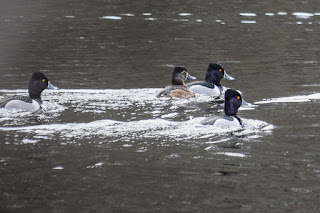
There were a great amount of birds around the St. Moritz Ponds, notably some Canadian Geese and a bunch of Ring-Necked Ducks! I enjoyed watching the ducks swim and dive as I brought out my zoom lens.


"How to identify:
    - Medium-sized duck with a peaked head. Both sexes have a gray bill with a white band and a black tip.
    - Males have a glossy black head, chest, and back with grey sides. Yellow eyes.
    - Females are brownish birds with a grey face and throat. Look for a bit of white around and behind their dark eyes.

        In truth, the Ring-necked Duck has a terrible name for identification purposes. You would think there would be an obvious ring around their neck, but you would be mistaken! The so-called ring on their black necks is such a pale brown that it’s nearly impossible to spot from any distance.
        Unlike most other diving ducks, these birds tend to inhabit and visit SHALLOW ponds and wetlands in Massachusetts. During the breeding season, you will usually only find two of them together, but in winter, they gather in flocks that number into the thousands of birds!
        They are one of the most likely ducks to eat leftover shotgun pellets, making them susceptible to lead poisoning. Lead shot was banned in 1991, which has helped their population numbers, but some old ammo still remains in wetlands across Massachusetts." (from Bird Watching HQ)

Thankfully, the ponds and trails were not as flooded as they were the last time I was over here. There were, however, an impressive abundance of chipmunks! I enjoyed my stroll along the Fire Pit Path, and noticed some possible beaver activity? Futher along, I imagined how different the area would have looked with the ski jump still intact.


My body was definitely feeling tired but I did not feel nearly as sick as last time I had COVID, almost two years ago. There was some running water between junctions 53 and 55, and I really enjoyed the winding trail between 20 and 42. 

Once back at the ponds, I admired the ducks for a bit longer and saw the first and only human of the day - again at a good, safe distance. The ducks were still around - yay! 


One final bit of excitement - about 30 feet from the Skyline terminus at the Shea Rink parking lot I saw someone, either setting up or backing up, a camping setup just off-trail. He had a wagon and everything, and I truly could not tell what the goal was here, and I also could not tell if he was doing this out of necessity or for hobby. Either way wishing him the best!

Step-By-Step
- Park at Shea Memorial Rink.
- Turn left onto Willard Street.
- Turn left onto woods at granite sign "St. Moritz Ponds."
- Follow path, at junction continue onto Winter Carnival Path.
- At terminus, turn right onto Minichiello Path (green dot).
- At 4205, turn right onto Pipe Line.
- At 4220, turn right onto Skyline Trail.
- Soon after, turn right onto Firepit Path.
- At terminus, turn right onto Minichiello Path (green dot). 
- At 4205, continue striaght onto Ski Jump Path.
- At terminus, turn left onto Murphy Path.
- At next junction, turn left onto Obbatinewat Path.
- At terminus, turn right onto Pipe Line (green dot).
- Cross Wampatuck Road.
- Continue on Pipe Line at 4166 (green dot). 
- At 4155, veer left onto Indian Camp Path (green dot).
- Before 4135, turn sharply right onto Crag Trail.
- At 4153, turn left onto Crags Foot Path. 
- Hike both end spurs, turn around.
- At 4155, turn right back onto Indian Camp Path (green dot).
- At 4120, turn right onto Furnace Brook Path.
- At 4142, turn right onto Crags Foot Path (green dot). 
- At unsigned junction, turn right onto unnamed path.
- At terminus at Skyline Trail, turn around.
- At terminus, turn right back onto Crags Foot Path (green dot).
- At 4174, turn right onto Skyline Trail.
- At next junction, turn left onto unnamed path.
- At terminus, turn right onto Shawmut Path.
- At terminus, turn around.
- At terminus, turn left onto green-dot trail (labeled as Crags Foot Path on 2020 map, but Quarry Path on previous ones).
- At 4148, turn around.
- Cross Wampatuck Road. 
- Continue on green-dot trail.
- At terminus, turn right onto Skyline Trail.
- Follow Skyline Trail back to car.