Distance: 7.64 milesElevation: 2,028 feetTime: 3 hours, 46 minutes (3 hours, 24 minutes moving)
Hike Type: Lollipop Figure-8 Loop
Hiking Challenges: N/A
The Hike
I had a shockingly great recovery after yesterday's sweaty romp around the Pock Monadnocks and after I checked the weather and saw that afternoon storms got pushed back to the afternoon - I was off to Mt. Wachusett! I took a classic pit stop at the Leominster Cumberland Farms, christened that bathroom, and was hiking at 8:30am!
It was a humid 76 degrees with a wet ground after last night's rain. The bugs were out, the songbirds were out, and the mountain laurel were past bloom (boo!). There were an excellent amount of efts on the ground, too. The Bolton Pond Trail initailly rises from the trailhead, dips down to join the stream, and rises gently again to the shoreline of Bolton Pond. Along the stream it was buggier and wetter, and I realized I forgot to start tracking my watch and phone until I made it to the pond... oh well.
It was very muddy by the pond but there was a nice view - sadly I couldn't stay for long because of bugs. The trail begins to rise more moderately with muddy, rocky, confusing footing. Thankfully there were some mountain laurel in bloom! Just as I began to enjoy it, my nose started to bleed? It was clearly going to be an interesting hike.
I passed a few more efts (one of which was starting to turn brown), cursed a few bugs, and eventually made it to the neat glacial erratic of Balance Rock. I followed the Balance Rock Trail right to Balance Rock Road, where the Old Indian Trail begins.
I started climbing on the Old Indian Trail and immedaitely started "stupid sweating" - the kind of sweating that socks your socks and allows bugs to drown on your skin. There were danging inchworms everywhere, almost acting like party streamers, just smaller, and gross. I could hear a breeze higher up, but it was stale down low. Eventually, the Old Indian continues left at a junction where the Semuhenna branches off right, and there is a nice walking break.
The trail crosses a small footbridge and opens up to the first crossing of a ski slope (Ralph's Run). There was a life-changing breeze and a lovely view from the opening. I had to wait a moment for my camera lens to un-fog before taking any photos, though!
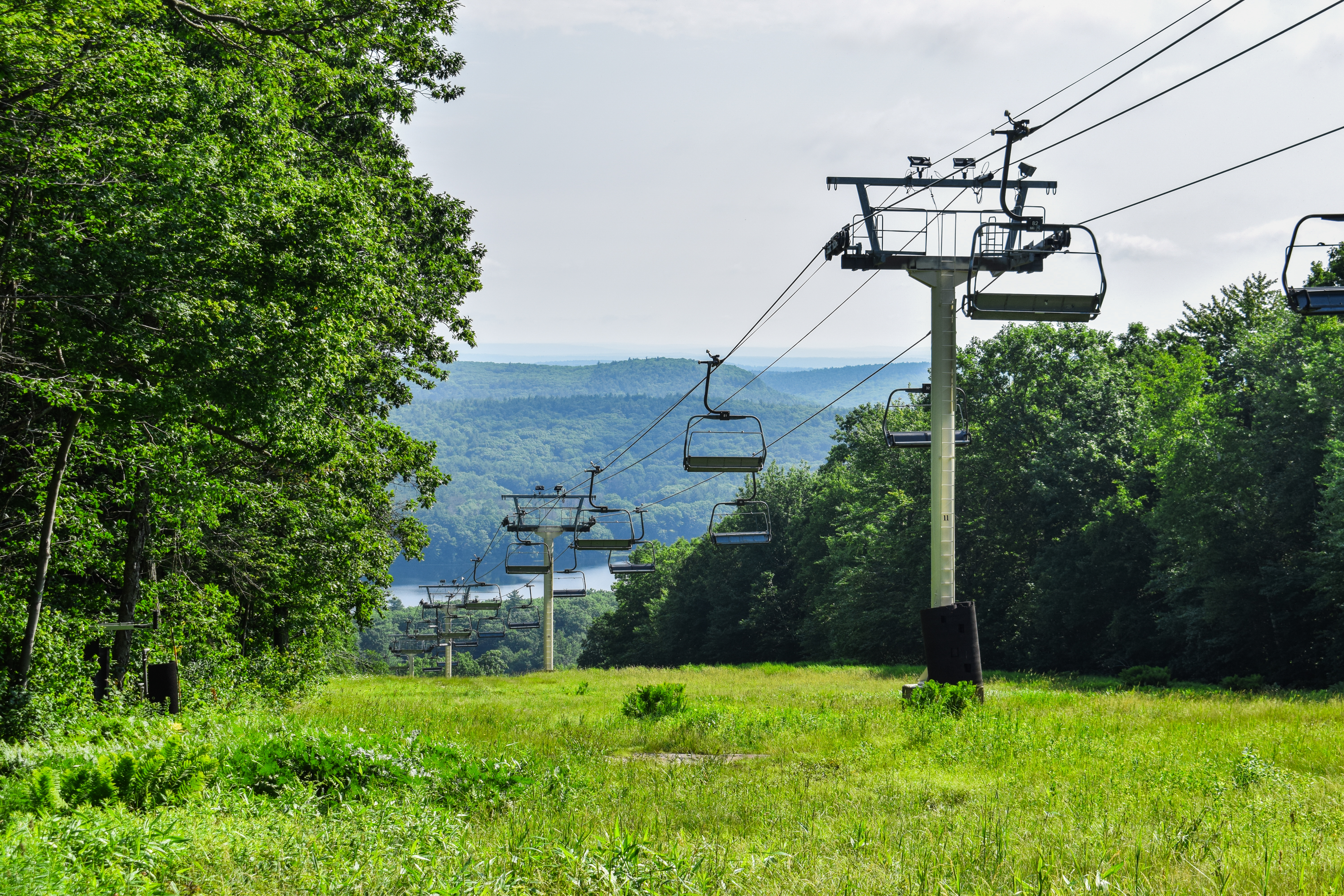
The trail goes back into the woods and comes to a wider crossing with even better views (Challenger and Look Mom), with the Minuteman Express Quad also in view. I took my sweet time enjoying the breeze and taking photos - I even saw a goldfinch!
The trail dips into the woods before a third and final ski slope crossing (Hitchcock Trail) with still nice views, but the second had the best, in my opinion. The climbing resumed after this crossing and climbed steadily until hitting the Summit Road.
The Old Indian Trail continues to climb after crossing the road, more steeply now, past some late-stage blooming mountain laurel. Being here at Mt. Wachusett (and in the heat) has me missing skiing!
The steep climb gets more rugged before leveling off at a plateau, which provided a wonderful, breeze walking break. This area was gentle with a few avoidable muddy sections. The trail crosses a top of the Polar Express Quad before a short, final push to the summit of Mt. Wachusett!
"Life at the Summit
The summit of Wachusett Mountain has a rich and varied history. A description of the summit dating from 1793 mentions pastureland and blueberry bushes, though only ox carts made it to the top before 1825.
Tourist Attractions Developed on Summit
By 1870, great numbers of visitors were drawn to the summit via Coast Survey Road - a rough, steep track on the mountain's southeast slope created for the federal Coast Survey mapping project. The first commercial structure on top was a basic sales stand, built in 1866 to accommodate these early tourists. The summit then developed rapidly as a popular destination. An 1886 ad promoting health benefits found at Wachusett had this to say - "Persons subject to attacks of hay fever and rheumatic experience great relief by a stay of a few days at the summit."
The Summit Scene Changes
The mountaintop looks very different today. Abandoned cart roads have become hiking paths and scenery is the featured attraction. The stables and bowling alley of bygone days have been replaced by communication towers, generators and radio equipment. Next to the pond, the Parker Lodge (built in the late 1930's by the Works Progresss Administration), houses communications for several state agencies. The building closer to the ski lift terminal houses equipment for various federal agencies. The fire tower also has communication equipment, used exclusively by the state's Department of Environmental Management." from summit kiosk.

There were just a few people at the summit including a DCR worker who was working to remove some graffiti on the tower. The views here are truly never amazing (I guess that's not fair to say... it is a lovely 350 degree vista, with the last 10 degrees being blocked by the communication tower), but the breeze brought me back to life! There was a rocky area of the summit that was fenced off with no signage, not sure why.
After a short break, a shirt wringing out, a chugging of liquids, I went to descend Harrington because I wanted to see the view. I knew I wanted to double-summit on this hike, so I decided I would center it around the views on the mountain (summit, Harrington ledges, High Meadow, and the view on Loop). The initial descent was pretty steep - my poles were very helpful with a few hand-moments. I started calling this stretch of trail "The Land of 1,000 Efts" - they were EVERYWHERE.
I enjoyed the view and continued down, eventually making my way to the Lower Link, passing what looked like some signage from a recent trail race? Not sure.
The Lower Link trail was in significantly better shape than the last time I hiked it, during spring melt. At the terminus, I turned left onto the Jack Frost Trail, eventually landing in a seasonally wet area with caution tape on knocked-down telephone wires.
The climb up Jack Frost is steep but beautiful and well-blazed. I was still incredibly sweaty, but not overheated, which I guess is a plus? The trail climbs through beautiful, open, mossy forests, eventually topping out at the junction with the High Meadow Trail, in a grassy area.
It was NOTICEABLY warmer on the High Meadow Trail. I began crossing paths with people for the first time all day on my High Meadow Trail descent, which was also pretty steep. I was really missing my ice cold water that I had yesterday, but in fairness, I didn't really plan on coming here on this day!
I took a quick break at the High Meadow view to drink some electrolytes and to wring out my shirt... again. The view was nice but hazy.
Now on the Bicentennial Trail, my brain took some to shut off and just enjoy the trip. I held myself to the rule that for a double-summit to count (on any mountain), a road must be reached in between the two summits, which came to bite me after passing a large downed tree (which I was able to count over 120 rings!) and following the Mountain House Trail down to the road.
It wasn't the descent to the Mountain Hosue Trailhead that was a challenge, but the short, relatively easy climb back up was a lot on this hot day where I was starting to feel pretty tired. The Bicentennial Trail got much buggier, wetter, and mountain-laurel-er after this junction, and even featured a snail on trail! That might be a first for me.
I made my way into the ridiculous rocky section where it felt like the trailbuilders went out of their way to find new boulders for the trail, and then turned sharply left onto Loop trail, soon making it to the nice view.
The Loop Trail is rugged but not insanely steep. Some rocks are wiggly, though, so care is needed. I did cross paths with one person who didn't see me coming and got scared - which seems to happen not infrequently - I truly don't think I am a quiet person, slogging my large body and pack through the woods!
Soon enough I made it back onto the Mountain House Trail and went for the final summit push. I was wet wet, exhausted, but determined to be done. Soon enough I was crossing the Summit Road, hitting the final bit of woods, and then doing the short walk up to the top from the parking area. Two summits = done!
"The Wonders of Wachusett
Welcome to the highest peak in eastern Massachusetts, whose spectacular views have drawn people for centuries. You join a long tradition of Mountain visitors. Writer Henry David Thoreau called Wachusett the "observatory of the state." Stand at the Mountain's edge and look at the open space surrounding you. Wachusett Mountain State Reservation consists of over 2,000 acres of forest, boulder fields, meadows and wetlands. A diversity of plants and animals flourish here. Historic structures and rock remnants provide clues about the Mountain's legendary past.
Whether this if your first of 100th visit, take time to explore the Mountain's hidden treasures and tucked away places. There is always something new to discover in the Reservation!" - from summit kiosk.
There was a MARVELOUS summit breeze - it was time for my long break. I was absolutely soaking wet, to the point where my palms hurt from wringing out my shirt - I didn't even know that could happen! I could feel my wet socks from inside my shoes. I took a seat up on the viewing platform and left the most insane sweat print on the wooden bench. Glamour was out the window, but I was thriving! It was now 81 degrees with rolling clouds under a higher haze. I had some summit leftover pizza and enjoyed the peace and quiet.
Eventually, I began to rally for my descent. I enjoyed the 360 views (and accompanying maps telling me what I'm looking at), the two summit signs about 30 feet apart, and reading the sign that was now up around the fenced-in area. (Also, there is apparently a USGS marker off-trail down by Pine Hill. I just learned this from a facebook post on the day I'm writing, July 5th, 2024).
I started my walk toward the Pine Hill Trail, passing a family comprised of a dad and two young boys who had matching speech impediments, which made the kids' arguing sound like they were British. This culminated in one brother tripping the other, resulting in screaming and crying, which just made me even more grateful to be on teacher summer!
The lovely breeze continued down the Pine Hill Trail, which has a spectacular, stone-step descent, usually lined with more stones. It is truly one of the most manicured, rugged trails that I've been on - its almost like a work of art. I'm curious if it parallels an old slide? Ledges are on the right pretty consistently, looking like an old landslide. I might start going through the Massachusetts Trail Guide books to see if I can get any more info on this.
The Pine Hill Trail continues its steep descent, past the Summit Road, and terminates at the Bicentennial Trail, which is also well manicured from this point to the visitor center.
I had a short road walk from the Bicentennial Trail to the Donbrowo Trail, which was no problem. I noticed in the woods there were trucks along the Donbrowo Trail?? Thankfully, they were just along a short stretch that splits from the trail and goes to the top of the Monadnock Express Quad - I did not have to do deal with any trucks on this trail.
My brain turned off for most of the Donbrowo Trail, only clicking "on" at the old fireplace remains. The spur leading down the beginner slope was well-defined and well-marked (now with signs), and then I went around the pond counter-clockwise two avoid two functions that were happening at the base area.
This led to a small stretch of trail along the parking lot, which was HOT. I had to follow AllTrails to know where the Balance Rock Trail began, but I was able to find it pretty easily as long as I stayed to the side.
I found the Balance Rock Trail and realized that I had accidentally stopped the AllTrails app, which wasn't a problem, but it was a bummer! I made my way back into the woods and gently climbed through a wild flip-flopping of swamp air and cool air.
Once at Balance Rock, I was officially on the descent. I passed a woman coming up and she asked me "are we crazy?" - the answer was yes. The bugs were less aggressive now, later in the day, and I spent most of my time on this final stretch on my phone making plans for the next two days, which is a little counterintuitative of the mission to get in the woods to avoid people, but it was shockingly highly productive! Soon enough I was back in the car in dry clothes and driving home (fun fact: the round-trip dive from my apartment to this trailhead was exactly one Hamilton album).
Step-By-Step
- Park across street from Bolton Pond Trail trailhead.
- Start hike on Bolton Pond Trail.
- At terminus, turn right onto Balance Rock Trail/Midstate Trail.
- Cross Balance Rock Rd.
- Continue onto Old Indian Trail/Midstate Trail.
- At next jct., veer left to continue on Old Indian Trail.
- Cross Summit Road, continue on Old Indian Trail until summit.
- At summit, continue onto Harrington Trail.
- Continue on Harrigton Trail past Link jct. and Semuhenna jct.
- At jct. with Lower Link, turn left onto Lower Link.
- At terminus, turn left onto Jack Frost Trail.
- At next jct., turn right onto High Meadow Trail.
- At next jct., turn left onto Bicentennial Trail.
- At next jct., turn right onto Mountain House Trail and hike to trailhead.
- At road, turn around.
- At same jct., turn left to continue on Bicentennial Trail.
- At next jct., turn left onto Loop Trail.
- At terminus, turn right onto Mountain House Trail to summit.
- At summit, continue right onto Pine Hill Trail.
- At terminus, turn left onto Bicentennial Trail.
- At terminus, turn left onto road toward Donbrowo Trail.
- Reenter woods at Donbrowo Trail.
- At terminus, follow path down beginner slope to base lodge.
- Walk around the pond counter-clockwise (eventually rejoining Midstate Trail.
- Walk through parking lot to Midstate Trail/Balance Rock Trail.
- Reenter woods at Midstate Trail/Balance Rock Trail.
- At Balance Rock, turn right onto Bolton Pond Trail - return to car.
"Old Indian Trail" from Massachusetts Trail Guide, 11th Ed. (2021)
This steep, rocky trail ascends the noth slpe of Wachusett Mtn. It begins on Balance Rock Rd. (closed to vehicular traffic), opposite the terminus of Balance Rock Trail. To reach the trailhead, begin at the parking area for Balance Rock Trail, which is to the north of the ski lodge off Mile Hill Rd. Alternatively, park on Bolton Rd. and climb to the trailhead on Bolton Pond Trail. Old Indian Trail leaves the road on the south side and proceeds through mixed hardwoods and pines. Semuhenna Trail enters right at 0.2 mi. At 0.4 mi., Old Indian Trail diagonally crosses a ski trail, reenters the woods, and passes under a ski lift at pole 12. The trail goes across Up Summit Rd., begins to climb gradually, traverses an intermittent stream, and then climbs steeply to a jct. with West Side Trail. Old Indian Trail continues steeply upward on stone steps and zigzags over rocks, crossing a ledge that on a clear day offers a view of Mt. Monadnock and Mt. Greylock. Here the route passes through an unusual grove of stunted old-growth forest. A few hundred feet above this point, Old Indian Trail levels off and climbs gradually to the summit, ending at the beacon tower on the north side.
"Harrington Trail" from Massachusetts Trail Guide, 11th Ed. (2021)
[...]. After passing Lower Link Trail and crossing three seasonal streams, Harrington Trail climbs more steeply, levels off, and resumes climbing among rocks. It passes jcts. with Semuhenna Trail on the left and Link Trail on the right near a rocky ledge and then continues northeast along the rugged upper slopes.
Harrington Trail goes over a stone wall along the side of the summit road, crosses the road, and then climbs northeast over less difficult rocks and ledges. The open summit is soon in sight, and the trail terminates on the flat rocks southwest of the fire tower.
"Lower Link Trail (DCR)" from Massachusetts Trail Guide, 11th Ed. (2021)
This 0.3-mi. trail parallels Administration Rd. and a brook. It serves as a short connecting route between the lwoer end of Jack Frost Trail and Harrington Trail.
"Jack Frost Trail" from Massachusetts Trail Guide, 11th Ed. (2021)
This trail is named for the late Dr. Harold P. Frost, who scouted and cleared most of its length. Located on the south side of the mountain, it climbs the peak's southern shoulder. To reach the trailhead, take Mtn. Rd. 1.2 mi. north from Princeton center. Turn left (uphill) at a Y intersection onto Westminster Rd. Parking is available at the intersection with Administration Rd., which is closed to motor vehicles. Machias Pool is a small pond adjacent to the parking area; the water is not potable, and swimming is prohibited. Proceed on foot up Administration Rd. for 0.4 mi., where the trail begins on a woods road on the right.
Jack Frost Trail crosses a brook and an intersection with Lower Link trail and then turns right and continues east until it crosses a power line at 0.3 mi. Here it ascends more steeply through old hemlocks, going along the lower ridge and passing an intersection with High Meadow Trail on the right. Jack Frost Trail then turns north along the brow of the ridge before climbing to the jct. with Mtn. House Trail about 0.2 mi. below the summit.
"Bicentennial Trail (DCR)" from Massachusetts Trail Guide, 11th Ed. (2021)
Rocky Bicentennial Trail serves as a connecting path for several of the popular summit routes. It begins at the visitor center and runs south parallel to Mtn. Rd., passing jcts. with Pine Hill Trail, Loop Trail, and Mtn. House Trail before turning steeply upward to end at High Meadow Trail at 0.7 mi.
"Loop Trail (DCR)" from Massachusetts Trail Guide, 11th Ed. (2021)
Loop Trail (0.4 mi.) provides a cutoff route that connects Bicentennial Trail and the middle part of Mtn. House Trail. The trailhead on Bicentennial Trail is just south of Pine Hill Trail.
"Mountain House Trail" from Massachusetts Trail Guide, 11th Ed. (2021)
Mtn. House Trail climbs rather steeply up an eroded pathway through hardwood forest, passing jcts. with Bicentennial Trail, Loop Trail, Jack Frost Trail, and Link Trail. It then turns north and corsses a stone wall near the auto road. From here, the trail levels off and parallels the upper auto road, reaching the summit at 1.0 mi.
"Pine Hill Trail" from Massachusetts Trail Guide, 11th Ed. (2021)
The shortest route to the top of Wachusett Mtn. is via this moderately steep old ski trail on the eastern side of the mountain. From the visitor center parking area, take Bicentennial Trail south to the Pine Hill Trail jct. Turn right onto Pine Hill Trail and begin the rocky ascent. After crossing the auto road, continue ot the nearby summit at 0.6 mi.
"Balance Rock Trail" from Massachusetts Trail Guide, 11th Ed. (2021)
This trail begins at the edge of the ski area parking lot on Mtn. Rd., about 1.2 mi. north of the reservation visitor center. Follow an old woods road for about 0.3 mi. before turning onto a woods path, which soon reaches Balance Rock, a glacial erratic. This path continues a few hundred feet farther to Balance Rock Rd. (closed to vehicles). Across the road, Old Indian Trail continues toward the summit.