Mt. Flagg & Mt. Shaw via Camp Merrowvista (Ossipee Range)
Distance: 6.99 miles
Elevation: 2,402 feet


The cloud ceiling was about 50 feet below the view ledges, so I had a fantastic view of a whole lot of nothing! Thankfully, I had already been here, and now I needed to find my way to the actual summit. I located the painted rock that points to Mt. Shaw, which is where the Gorilla Trail officially begins, blazed in yellow with a red center.

[7:48am - Gorilla Trail]


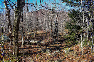
Eventually, the Gorilla Trail began to climb more moderately, but thankfully never too steeply. The path became a bit more obscure once the climbing resumed, but as long as I took it slow, followed the logical pathway, and always double-checked for blazes, I was fine. There were some intense gusts of wind, and just when things got quiet... FLAP FLAP FLAP! A grouse genuinely scared the living daylights out of me. Horrid creatures. I also noticed a few little poops on a few rocks that had a white "cap" - which apparently are also from the grouses!

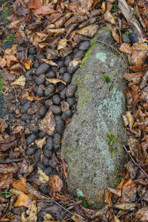
Continuing to climb, the trail got a bit more challenging to follow as the trail hit a few meadowy stretches (and another pile of moose poop). Some of the bushes were whipping my shins with impressive might.


I traversed over the bouldery PUDS, which were much dryer and easier now, eventually landing in the coniferous cols, existing the Lakes Region Conservation Trust.

[10:08am - Gorilla Trail exits Lakes Region Conservation Trust]


I think this posting was in reference to the famous Ossipee Mountains drama regarding the Trail Bandit. A great write-up of this can be found on https://www.franklinsites.com/hikephotos/Ossipee/.

Elevation: 2,402 feet
Time: 4 hours, 41 minutes (4 hours, 4 minutes moving)
Hike Type: Out-and-Back
Hiking Challenges: 52 Hike Challenge; Ossipee 10
Hike Type: Out-and-Back
Hiking Challenges: 52 Hike Challenge; Ossipee 10
The Hike
Last day of the three day weekend and time for REDEMPTION! My 3:45am alarm went off and I was out the door at 4:00am to head back to Camp Merrowvista to actually get to the summit of Mt. Flagg (and maybe Mt. Shaw?). It was misting/raining in Boston, but the forecast was partly cloudy for the Ossipees. My drive was realtively easy with a quick christening at the NH Visitor Center on I-95 and the Circle K in Ossipee. I grabbed a couple of breakfast sandwiches from Ossipee as the sun was beginning to rise.
The sky slowly began to lighten on the final stretch of my drive, landing me back at Camp Merrowvista at 6:30am. The welcome sign to the camp said "Welcome Hikers - Park at Farmhouse," which was nice to see (it still felt like I wasn't supposed to be there, though!). Skies were dark and gloomy, and it clearly had rained overnight/into the morning. All of the peaks were in the clouds which was... a bummer! I told myself I'd decide if I'm going to add Mt. Shaw when I hit the summit of Mt. Flagg based on how brutal the hike up was.


[6:37am - Start of Hike on Class VI Road]
My hike started on the class VI road heading toward the Mt. Flagg trail. It was on the warmer side of chilly out, at 50 degrees and windy. I really have hiked in all four seasons the past week (Wednesday was summer, Saturday was winter, yesterday was spring, and today we're back in fall)!

[6:42am - Mt. Flagg Trail]
My puffy came off once in the woods and my fleece soon after, as typical. I know the advice is to "be bold and start cold," but I find it so much easier to "deal with it later." Skies overhead were varying from light to dark grey with loud wind overhead. I made it past the junction with the green blazed trail and rose steadily to the Dave Green Trail junction.

[6:51am - Mt. Flagg Trail & Dave Green Trail jct.]
Just past the junction I saw another trail that I didn't notice on my last visit - a trail blazed in a salmon-pink. It's not on AllTrails or the Trail Bandit map - I wonder where it could go? Maybe to the brook? Or a different way to loop back to the camp? A mystery for sure!


The climb from Dave Green to the Canaan Mountain Trail junction is a doozy - steep and generally unrelenting with rough footing (and very leafy). Up above, the sky was starting to show some hints of blue, but the hints were alternated with a DARK grey.

[7:13am - Mt. Flagg Trail & Canaan Mountain Trail jct.]
After the Canaan Mountain Trail junction was the boulder field, which I took slower than last time, which did my legs good. Someone on Facebook described this stretch of trail more treacherous than trails in the Whites, which I think is a bit of an exaggeration. Sure, its more technical than the well-manicured trails of the Castle in the Clouds Conservation Area, but its very manageable if you watch your footing.

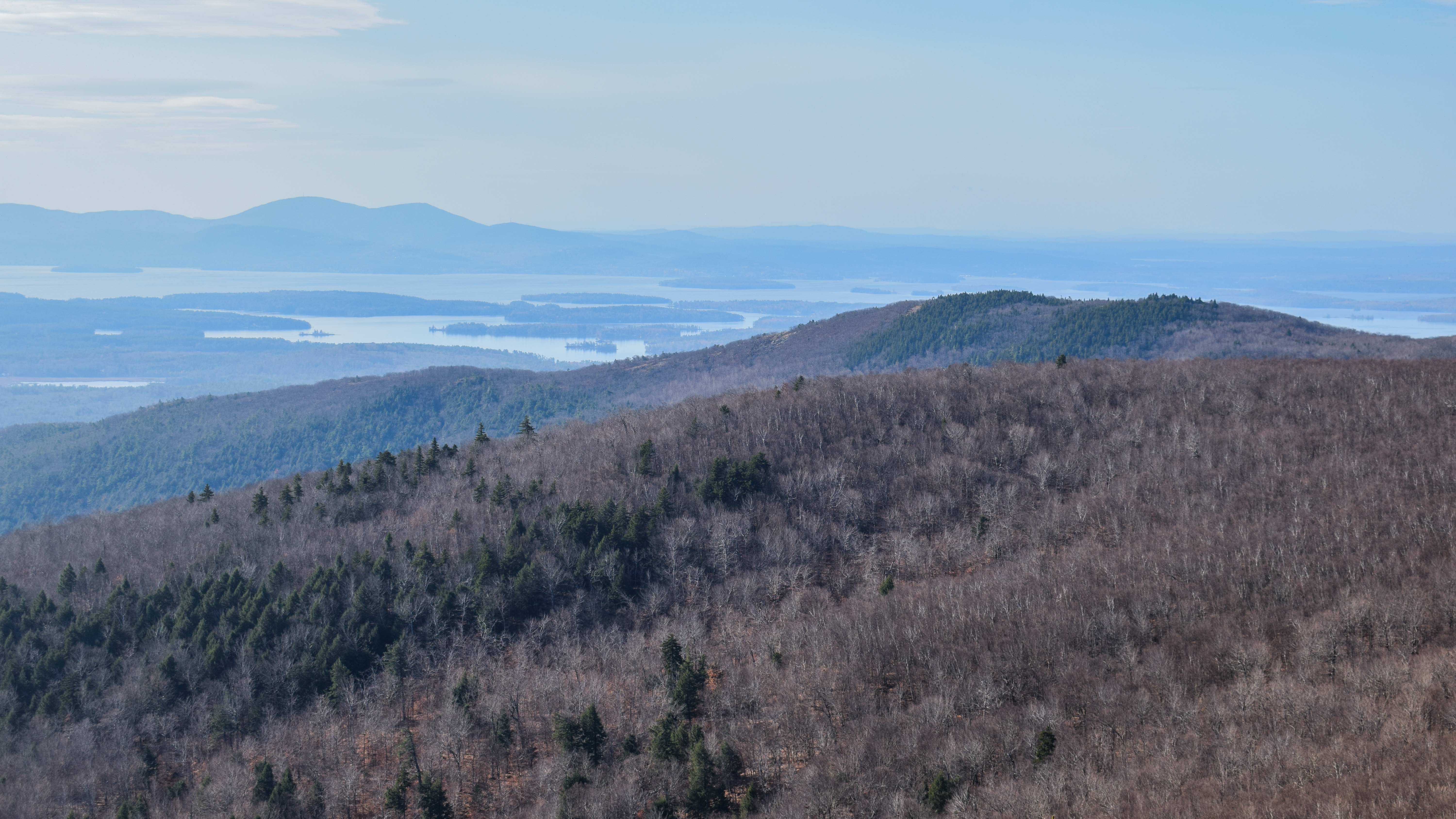
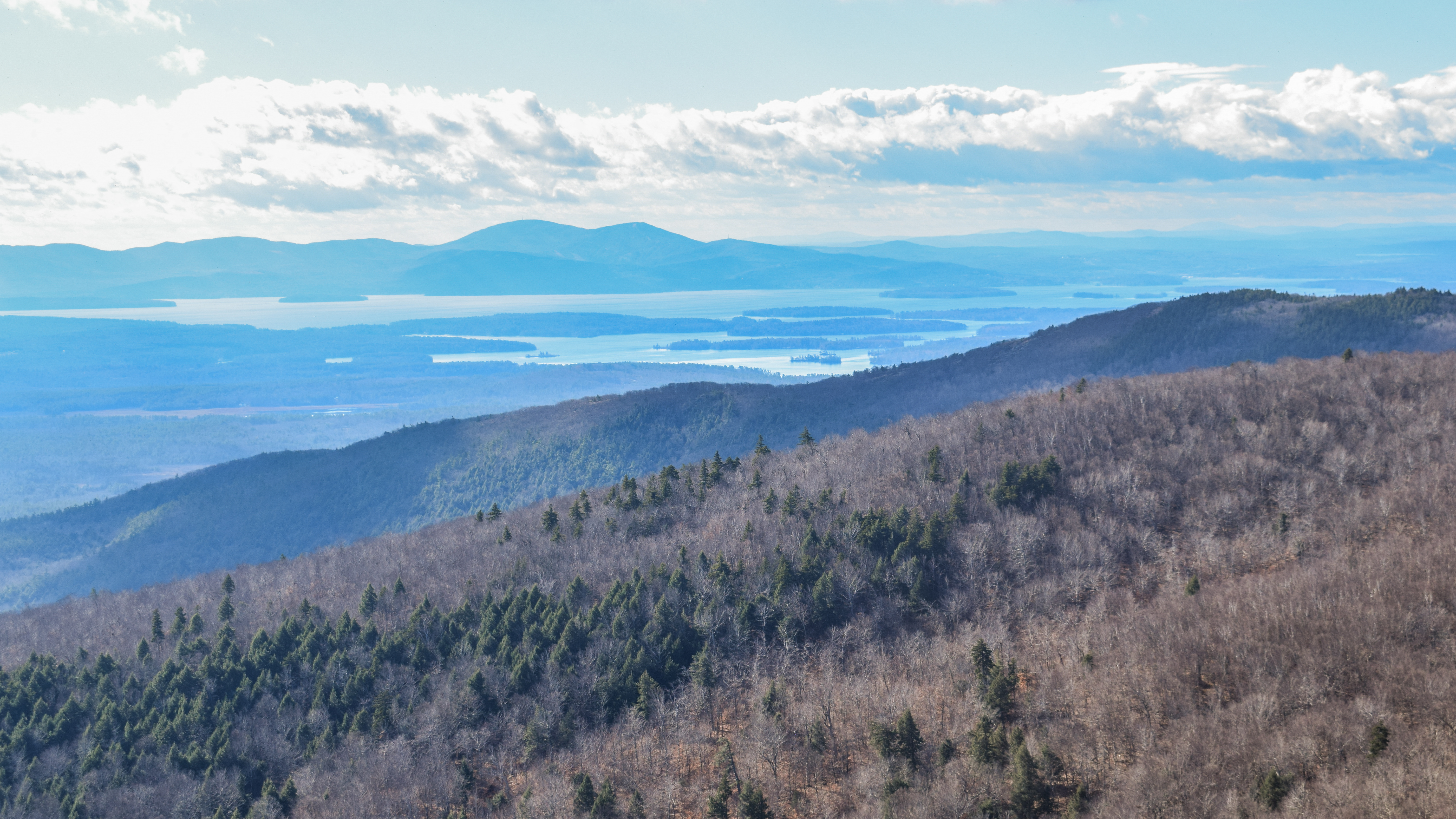
Higher up, where the beautiful slabs begin, I noticed that I was officially ascending into a cloud... oh well! One thing I am good at is hiking in clouds! The scenery of the trail and woods was still beautiful, and nice to see in this different light. The howling winds added a bonus layer of spook, too. I did get one view toward Lake Ossipee, just below the cloud ceiling.


The Gorilla Trail initially scrambles off of the ledges into a beautiful, mossy forest. The footpath was narrow, but it was easy to follow. The sun even made its first appearance (still very cloudy, though). I was feeling good, and even though Mt. Shaw was in the clouds, I decided to continue on, knowing that the Gorilla Trail is seldom-used and has been labeled as tough to follow.


[7:54am - Mt. Flagg Summit]
The summit was marked with a cairn and a partial view (of clouds). I did get one partial view through teh clouds, but didn't wait around for long. The descent of the summit was the most challenging part of the Gorilla Trail - very overgrown (like, trees in the way overgrown), mossy, and bouldery (and slippery!). I slipped a few times on this descent, but never fell! I took it nice and slow and eventually made it down to the first col between the two peaks.


[8:06am - Gorilla Trail enters Lakes Region Conservation Trust]
The Gorilla Trail enters the Lakes Region Conservation Trust in the first col and then goes over a hump to a second. From here, the trail traversed a tricky bouldery stretch with a few PUDS. There wasn't always a clear footbed, but there was frequent blazing, even though it was mostly faded. While researching for this hike, I found the following history (on AllTrails, so we can take it with a grain of salt):
"I was a member of the Merrowvista group that blazed the Gorilla Trail in 1971. A group of 15 year-old-kids, dubbed "Gorilla Village" by our two counselors because we had a few real hulking dudes in our group. I spent 10 summers at Merrowvista, first as a camper, then as a staffer, and knew these trails quite well. Last visited in 2018. The Flagg summit is a lot more overgrown than when I was a kid, because then it was still pretty bare from a 1954 fire. Much of the lower part of the trail to Flagg is the fire road from that year." Paul Menser, November 20th, 2023 on AllTrails

The boulders eventually led into a cloud which was... fine. The woods were definitely spooky! Wind was still howling up high, but it was pretty tame in the trees. The trees themselves were mostly birch, and I was delighted to discover that the leaves hardly covered the trail - overall it was in much better condition than I anticipated!


There was a really lovely stretch of relatively flat trail after the boulders, and I even stumbled upon a pile of old moose poop. This hike had been pretty devoid of wildlife, so I was thrilled with this llittle bit of excrement!


After the meadow, the Gorilla Trail climbs to a narrow ridge where the trail is even more challenging to follow, but overall it stays on the ridgecrest. The wind was blowing hard and water droplets were pelting me in the face. Thankfully, the ridge leads to the summit of Mt. Shaw!

[8:58am - Mt. Shaw Summit]
...which was still in a cloud. I guess I expected it at this point... I took a seat for some food and hydration and stared into the void for a while. In reflection, the Gorilla Trail was in much better shape than I had anticipated! I actually enjoyed the trip, and was not dreading the return. Visually, it was a stunning trail.

It was super windy all around me, but the viewpoint was well-sheltered. It was 43 degrees out now, and just when I was packing up the clouds parted for truly no more than three seconds. I THREW my Nalgene out of excitement to grab my camera, but the view closed up before I had a chance. I INCHED away back toward the trail, hoping a view would open up again. I think if I stayed for another 20 minutes, I would have had an excellent view, but it was a school night, and I needed to start me return trip. With my tail between my legs, I got back to the Gorilla Trail.

[9:17am - Gorilla Trail]
Immediately, I noticed there was much less fog on my return trip. I got off-trail a few times on the initial descent through the aformentioned tricky areas, but I was able to get back on on my own accord (i.e., not needing to use my phone for GPS). As the trail descended, the sky began to open up to a big, beautiful blue. Oh well!


The forest had an insanely different vibe now that the sun was proudly shining. Even though I was lamenting not getting that amazing view from Mt. Shaw, I was still happy to be in the woods. From the walking break area, there was an incredibly rude tree view of Mt. Shaw, completely cloud-less, though.


The climb back up to Flagg was still a bit slippery and dicey, but much easier than the descent. I quickly made my way back up to the summit, excited to hopefully get a view this time! I was a little too excited, though, becuase I went too fast and fully gassed out my lungs... oops.
[10:16am - Mt. Flagg Summit]
I was delighted to get views back to Mt. Shaw and up to the White Mountains from the summit. The views are by no means panoramic, but they were nice nonetheless, and unique! I had never seen Mt. Chocorua from this angle before, which made it look more like a single Tripyramid, rather than the mountain the Grinch lives on. There was also a highly impressive view to Carrigain Notch, which looked incredibly dramatic. From the top, I continued on back to the ledges.


[10:24am - Mt. Flagg Trail]
Winds were going strong on the ledges, reading at 15-20 mph. The sun was shining brightly, which kind of felt like an reward for finishing the Ossipee 10 (and hitting a bonus peak!). My descent was slow and steady with a few sketchy slips, but mostly becuase I was excited to be all done. Once I slowed down I was completely fine. This bit of trail was so pretty in the sun!


[10:50am - Mt. Flagg Trail & Canaan Mountain Trail jct.]
I made it to the shelter at the Canaan Mountain Trail junction and started the steepest part of my descent - SLOW and steady, especially in the spots with thick leaf cover. I also passed a very hair poop. I think it was a coyote?
[11:07am - Mt. Flagg Trail & Dave Green Trail jct.]
At the junction with the Dave Green Trail, I noticed that the "WELCOME" sign had another sign beind it, it read:
"Trails Closed. Due to improper use and damage to the property's natural resources all trails are closed until further notice. All public access onto this land is by writter landowner's permission ONLY."

The hike from here to the car was quick and easy, taking just over 10 minutes.
[11:14am - Class VI Road]
[11:18am - End of Hike]
There were a few other cars in the parking area when I wrapped up and I saw one person working, but besides that it was a completely human-free day! The only other bit of excitement left was driving through two brush fires on I-95 in Massachusetts near Topsfield (I think). Ossipee 10 = Complete!

Step-by-Step
- Park at Camp Merrowvista.
- Follow Class VI road to trailhead.
- Enter woods on yellow-blazed Mt. Flagg Trail.
- Follow Mt. Flagg Trail to Mt. Flagg's eastern ledges.
- At ledges, continue onto yellow/red-blazed Gorilla Trail.
- Summit Mt. Flag, continue on Gorilla Trail.
- Summit Mt. Shaw, retrace steps back to car.
"Gorilla Trail" from A. M. C. White Mountain Guide, 20th Ed. (1972)
This trail leads from Mt. Shaw to Camp Merrowvista, located about 1/2 m. NE (beyond) the sharp R turn in the road mentioned in the beginning of the Thunderbird Trail description. The section from Mt. Shaw to Mt. Canaan is blazed with orange and green surveyers paint, frequently in the shape of a gorilla. Beyond, the blazes (1971) are less distinct, but the trail is well-used. It is suggested for the descend because of the confusion of trails near Camp Merrowvista.
The trail leaves the carriage turn-around on the summit and descends generally to the SE. Soon it heads more to the E. It is a rough trail, passing through the burn of 1953. There are fine views as it passes over Gorilla Mtn., near the summit of which a short side trail L leads to Gorilla Leap. There are also fine views from the ledges of Canaan Mtn. Descending from the latter, it passes a trail L to Bean Pond, and soon leaves the burn. Some distance beyond it passes a shelter L and picked up a wood road. It passes a large pile of slash lumber R. As the wood road approaches Bodge Brook, a trail crosses it at a sign "Vesper Trail." Turn R, descend to and cross the stone bridge, and continue straight (uphill) along another wood road, soon passing through Camp Merrowvista. Continue straight 1/2 m. to the bottom of the Thunderbird Trail.
"Gorilla Trail" from AMC White Mountain Guide, 23rd Ed. (1983)
This trail runs about 4.5 mi. from the summit of Mt. Shaw to Camp Merrowvista. The trail starts east of the old carriage road turnaround on the summit of Mt. Shaw and follows the ridge eastward. It is well blazed but rather rough in places, with many boulders. The trail ends at Camp Merrowvista, which is located about 2.3 mi. from NH Rte. 171, 0.5 mi. beyond the start of the Thunderbird Trail.