Mt. Parker (White Mountain National Forest)
Hike Type: Out-and-Back
Elevation: 2749 feet
Time: 4 hours, 27 minutes
Hiking Challenges: 52 With-a-View, 52 Hike Challenge

For context on the quote, as of October 2nd, 2022, the Miami Boy's Choir song 'Yerushalayim" is currently taking over TikTok and the hearts of every millennial who has unknowingly stumbled upon it, and therefore was the only thing happening in my head during this hike. ANYWAY. Gen was feeling sick so no 4k this weekend, so it was off to another 52 I go! I first thought about doing South Moat and then driving for another, maybe Doublehead, but with foliage near peak I wasn't confident in finding a parking spot around prime hiking time, and the weather was going to be cloudy, and I wanted to do South Moat on an amazing day. A plus side of the weather getting colder is that the sun rises later, so I got to sleep in until 3:45am! Officially on the road around 4:15am, took a long stop at my favorite place ever, the Hooksett Rest Area, where I got gas, filled my tires with air (something that I've been putting off for a while), and christened the bathroom (I could tell it was going to be a good day when I already had to use the bathroom AND Cher was playing). I then took another stop at Lincoln Woods to christen that bathroom (what on earth did I eat...), and had to use the porta potty, which had a cup holder. There was a beautiful sunrise on the Kanc, and then I eventually made it to the trailhead around 7:20am.

I pulled in just after another car, so I dawdled and let them get a head start. I took some photos from the Saco River across the street, and slowly started getting ready. There was some awkward waiting around, but I didn't want to play leap frog (and I wanted them to get all the spider webs for me). It was chilly - 37 degrees, so I played around with every possibility of layering I had, and eventually got my hike started!

In hindsight, this hike can be split into three sections: the logging area, Oak Ridge (wilderness boundary to wilderness boundary), and the Mt. Parker Trail. The hike starts in the logging section, following an old road that has plenty of vegetation, but a clear footpath. Right away there is a gravesite for "Dr. Leonard M Eudy - He gave his life to the people of Bartlett." There is a great blog post about his story here. Soon after there is a junction for the Cave Mountain trail. The White Mountain Guide and the 52 With a View guidebook both state that careful attention needs to be paid to stay on the trail, but it was very obvious to me. There were a couple signs indicating the direction of the trail for added guidance. I soon realized that I did not wear deodorant, and that was a bummer. I had also adjusted my "boob strap" to sit lower and loosened the shoulder straps, and it ended up being much more comfortable (I saw a photo of me from Owl's Head that looked like my boob strap was suffocating me). My new shoes were feeling decent, but I had a zit on my beltline that was an issue - a beginning filled with emotions!

The second section starts at the Wilderness Boundary, where the woods makes an immediate switch from brushy logging area to actual woods. There is a minor water crossing that can be rock hopped, and then the trail parallels the brook for a moment. Soon after it starts to climb up to Oak Ridge, the mini peak between here and Mt. Parker. The trees are starting to really show some color, we're at least a few days to a week away from peak foliage. The trail alternates with steeper sections followed by short walking breaks. Sadly, I could hear cars at this stretch, which in the grand scheme of things is fine, but I was cranky. This climb truly felt like it went on forever, and the fact that it was relatively featureless didn't help. I was also summer sweating, even though it was chilly out, which was a bummer. I promise I enjoyed this hike! I was definitely in a cranky mood, though, haha. One major positive was that the forest was full of really cool and interesting fungi, which helped!


The trail hits its crest at the top of Oak Ridge, which is featureless, and then steeply descends back down about (I think) 200 feet, and eventually bottoms out at the col between Oak Ridge and Mt. Parker, which is where the trail leaves the wilderness area and hits the junction with the Mt. Parker Trail, which leads left. On a side note, my pack smells BADLY. Also, there are salt crystals on everything inside. I wonder if getting a waterproof pack for the summer would help that? I know I will not be sweating any less as the weather heats up again next spring, but I would love to do a little bit of preventative damage control.

The col, even though not technically in the Wilderness Area anymore, feels very remote, which was a great place to be. The trail really gains brownie points here. There are excellent switchbacks and plenty of walking breaks. As "Yerushalayim" continued to play in my head, I saw movement out of my right eye, and it was a beautiful Barred Owl. I'm always amazed at how quietly owls can travel from tree to tree. The owl had its head down as I was trying to get a photo, but when it heard my shutter its eyes snapped up to look at me, which was spooky! I took a few more photos and then left the owl to do its thing without me. About 5 minutes later I heard an incredible call from that owl that truly echoed throughout the woods - it was beautiful!


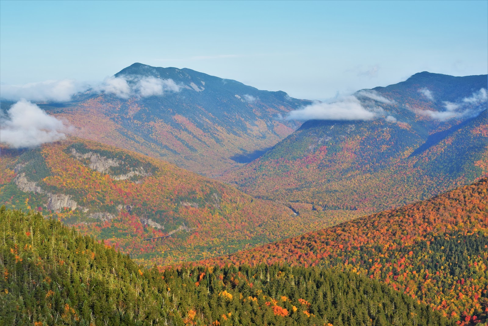
Now finally near the summit, I passed the couple that parked just before me this morning (they were much more friendly now!). Just before the summit there is a beautiful stretch of woods with a tall tree covered in yellow and some lovely ferns, and then the world opens up to the amazing views toward Crawford/Resolution on the left, Washington straight ahead, the Wildcats/Carters to the right, and finally ending with Kearsarge North to the far right. The colors were present, but dull, but that could be attributed to the cloud cover. Lots of reds coming off the ridge connecting to Iron Mountain.

I took a nice long break to eat my peanut butter sandwich and my prosciutto/mozzarella rollups. The return trip went incredibly fast, which felt good. I passed a good amount of people on their way up, all with their own very unique characteristics: there was cool guy who was just happy to be in the quiet woods, a loud family who were just there for a good time, an inquisitive couple who wondered about my journey, and a bickering couple who were having a tough time reading the sign at the col.

My enjoyment of other peoples' lives stopped abruptly when I had to climb back up Oak Ridge - ouch. I was not thrilled. I passed one trail runner, and just past the summit I found my favorite person of the day. She starts by asking "can I ask you a question?" and then goes on to say "Does this ever get better? Is it even worth it? This sucks. I promise I like being in the woods!" to which I giggled, agreed about this first part, but said that I would consider the view worth the boring trail. I would later see her back at the parking lot sitting in her car, so I guess I didn't do a great job convincing!
Once back out of the wilderness area, I passed two more couples and really flew down the trail. My legs were burning, but the worst part was when the sun came out and the sky turned blue. I had a nice hike, but I found it very rude that the sun waited for me to be done to open up! The audacity. I sat at the Saco while I wrote some notes down in the notebook, and then worked my way home, eventually getting stuck on the Kanc for 20 minutes due to road work. At least its a lovely day!
Step-By-Step
Start hike at Mt. Langdon Trail Trailhead.
At jct. with Cave Mt. Trail, continue on Mt. Langdon Trail.
Watch carefully to stay on Mt. Langdon Trail.
Enter Presidential Range-Dry River Wilderness.
Summit Oak Ridge on Mt. Langdon Trail.
Continue onward and descend Oak Ridge on Mt. Langdon Trial.
At jct., turn left onto Mt. Parker Trail.
Summit, retrace steps back to car.

“Mt. Langdon Trail” from White Mountain Guide, 30th Ed. (2017)
“This trail runs to Mt. Langdon Shelter from the road on the north side of the Saco River near Bartlett village, meeting both Mt. Parker Trail and Mt. Stanton Trail, and thus gives access to both the higher and lower sections of Montalban Ridge. Despite its name, Mt. Langdon Trail does not get particularly close to the summit of Mt. Langdon, which is crossed by Mt. Stanton Trail. Most of Mt. Langdon Trail is either within or close to the boundary of the Presidential Range-Dry River Wilderness; Mt. Langdon Shelter is just outside the Wilderness Area. The first 1.0 mi. of this trail is located on private land.
From the four corners at the jct. of US 302 and Bear Notch Rd. in Bartlett village, follow River St. (the road that leads north) across a bridge over the Saco River to a T intersection at 0.4 mi. and bear left a short distance to the small trailhead parking area (sign) on the right. The trail follows a brushy logging road, continuing straight on the middle road at a three-way jct. in 75 yd., and climbs north at easy to moderate grades through an area of recent logging where there are intersections with numerous diverging logging roads. In general, the trail follows the main road straight ahead (north), and directional arrows and some blazes are found at the major intersections, but great care must be taken to follow the correct route. At 0.3 mi., the path to Cave Mtn. (marked by a small sign) diverges left. At 0.8 mi., Mt. Langdon Trail veers slightly right at an intersection of several roads, and at 0.9 mi., the trail bears left off the main road. The trail enters the Presidential Range-Dry River Wilderness just before crossing a brook at 1.0 mi. After recrossing the brook, the trail climbs more steadily with gravelly footing, bearing sharply right twice.
Mt. Langdon Trail crosses Oak Ridge at 2.2 mi. after passing through an usual stand of red oak and descends, sharply at times, to the Oak Ridge - Mt. Parker col, where the trail bears right at 2.5 mi.; at this jct., Mt. Parker Trail continues ahead. [...].”
“Mt. Parker Trail” from White Mountain Guide, 30th Ed. (2017)
“This pleasant, rugged, lightly used trail passes several excellent viewpoints and provides access from Bartlett to Mt. Parker, Mt. Resolution, the Stairs Col area, and the upper Montalban Ridge. The trail runs almost entirely within or close to the boundary of the Presidential Range-Dry River Wilderness. Parts of the trail may require care to follow due to blowdown and encroaching brush, although experienced hikers should have little problem. No reliable water is available on this trail.
The trail begins in the Oak Ridge - Mt. Parker col 2.5 mi. from Bartlett, continuing straight ahead to the north, where Mt. Langdon Trail turns right (east). Mt. Parker Trail climbs moderately with many switchbacks through brushy beech and oak woods, descends briefly to the right, and then swings left and continues its winding ascent to the open summit of Mt. Parker at 1.4 mi., where there are excellent views, especially north up Rocky Branch valley to Mt. Washington. [...].”