Showing posts with label Wapack Trail. Show all posts

Sunday, November 10, 2024

Mt. Watatic, Frank Robbins Trail, & State Line Trail (Mount Watatic Reservation, Asburnham State Forest, Binney Hill Preserve)

Mt. Watatic, Frank Robbins Trail, & State Line Trail (Mount Watatic Reservation, Asburnham State Forest, Binney Hill Preserve)

Distance: 7.03 miles
Elevation: 1,093 feet
Time: 3 hours, 17 minutes (2 hours, 56 minutes moving)
Hike Type: Double Lollipop Loop
Hiking Challenges: 52 Hike Challenge; Operation Alaska Benchmark Challenge; Friends of the Wapack

The Hike
Day two of this wonderful three-day weekend! The plan was to take it easy today but still get outside. Sarah texted me asking if I wanted to hike something since she had to drop Alec off at the airport at 5:30am, so we decided to meet up and hike Mt. Watatic (and the two additional Friends of the Wapack trails that I needed for my patch). I stopped at Dunkin Donuts to get breakfast and met at the trailhead right before 7:00am. It was a surpringly chilly 25 degrees out, but beautifully sunny. There were a few families coming down after a sunrise hike, so we had the whole mountain to ourselves!


[7:10am - Start of hike on Midstate/Wapack Trail]
The hike started with my hip burning - apparently it chafed pretty hard on Mt. Garfield yesterday... oh well. The hike in is initally flat, passing a beautiful pond/meadow.


[7:19am - Jct. with State Line Trail]
After a relatively flat start, the Midstate/Wapack Trail begins to steeply climb up to the summit. Layers quickly came off as we made many jokes about how strenuous the trail was - comparing it to the Wildcat Ridge Trail at times (we were being very dramatic). Near the top, we got a nicely framed view of Mt. Wachusett.


[7:49am - Mt. Watatic Summit]
Soon enough we were at the top! Stunning views, arguably better than those on Mt. Wachusett. Temperatures had warmed up to 35 degrees and there was a 5-10mph breeze. We found a spot on the ledges to enjoy our breakfast as we pointed out landmarks (notably Pack Monadnock and Boston). A few people came and went as we enjoyed our food before we packed up and continued on!


[8:12am - Midstate/Wapack Trail Northbound]
The trail from the summit to Nutting Hill was through beautiful woods, and Nutting Hill to the parking lot spur path looked recently leaf-blown. From the parking lot spur path to the NH State Line the trail was covered in leaves and acorns, which made for some exciting footing! Thankfully, it was flat and dry. 


[8:47am - New Hampshire State Line on Wapack Trail]
"Live Free or Die!" we chanted to ourselves as we entered New Hampshire on the Wapack Trail. Footing continued to be leafy, rocky, and acorn-y, but now it was also descending, which felt more slow-going than it actually was. We slowly continued into the Binney Hill Wilderness Preserve, right up to the junction with the Frank Robbins Trail.


[9:01am - Frank Robbins Trail]
The Frank Robbins Trail was... fine. It was decently overgrown and brushy. We were very grateful to be doing this in the fall when the plants were dying/dead and ticks are generally asleep - it would be a doozy in spring/summer! The later half of the trail was actually really nice. It had a wilder feeling to it with lots of moss. Eventually, the trail turned onto Binney Hill Road, and eventually turned into the Wapack Trail, now heading southbound.


[9:29am - Wapack Trail Southbound]
Back on the Wapack Trail, we gently ascended on Binney Hill Road and turned right into a reforesting meadow. The brown grasses were as tall as us! We tragically hiked past a decomposing Blue Jay and continued our way back to the beginning of the Frank Robbins Trail - completing the second lollipop candy of the double-lollipop loop. We heard A LOT of gunshots from this point to the end of our hike, and only realized how close the Fitchburg Sportsmen's Club was to these trails.


Thankfully, the climb back up through leaves and acorns was much easier than the descent, and we quickly arrived back in the Commonwealth of Massachusetts!

[9:59am - Midstate Trail Connector]
Right after the state border a blue-blazed trail, the Midstate Trail Connector, turns right to follow the border for a very short stretch. On the right, there is a unique monument, octagaonal in shape, with "BORDEN 1834" inscribed. A forum on Views from the Top says its a monument to honor Simeon Borden, a prominent surveyor of the time/area (Wikipedia Link; VFTT Link). Soon after is the terminus of the Midstate Trail at a large monument from 1894 showcasing the state boundary, with a smaller monument next to it. 


[10:01am - State Line Trail]
Now we were following the blue-blazed State Line Trail, which gently meandered through the forest, partially paralleling the Midstate/Wapack Trail. This eventaully turned onto a woods road (that doubled as the parking lot spur), where we passed many people climbing up Mt. Watatic the back way. Sarah and I were both hungry by this point, but we realized it was only 10:00am! We decided brunch was in our future.


[10:23am - Midstate/Wapack Trail]
The final stretch of our hike was on the Midstate/Wapack Trail, repeating this stretch to get back to the car, past the pond/meadow, and into the busy parking lot. This was a lovely hike! Also, now I can cross off two more trails from my "Friends of the Wapack" trails challenge that I made for myself...


[10:31am - End of Hike]
We ended our morning at the Smith Hill Tavern in Ashby, which was actually amazing. We had medium hopes, just happy to get food. Prices were higher than a diner, which is what we wanted, but the quality was to die for! We both got eggs benedict, which were perfectly poached (and buttered!). The potatoes that came with the bennies were incredible, and I also got a side of toast and bacon, which also blew me away. What a perfect way to wrap up a nice morning!


Step-By-Step
- Park at the Mt. Watatic Trailhead. 
- Start hike along yellow-blazed Midstate/Wapack Trail.
- At jct., turn left to continue on Midstate/Wapack Trail.
- At summit, continue on Midstate/Wapack Trail.
- At NH State Line, continue on Wapack Trail.
- At next jct., turn left onto white-blazed Frank Robbins Trail.
- At terminus, continue straight on yellow-blazed Wapack Trail (southbound).
- At jct. with Frank Robbins Trail, continue left on Wapack Trail.
- At NH/MA border, turn right onto blue-blazed Midstate Trail Connector.
- At terminus, turn left onto blue-blazed State Line Trail.
- At terminus, continue straight onto Midstate/Wapack Trail.

Sunday, May 12, 2024

Wapack Trail: Turnpike Road to Stony Top (Windblown Property, Wapack Wilderness)

Wapack Trail: Turnpike Road to Stony Top (Windblown Property, Wapack Wilderness)

Hike Type: Out-and-Back
Distance: 8.18 miles
Elevation: 1,667 feet
Time: 3 hours, 27 minutes (1 hour, 57 minutes moving)
Hiking Challenges: 52 Hike Challenge, Wapack Trail, Freinds of the Wapack

The Hike
Oh boy. The grand finale of the Wapack Trail. I was NOT feeling great! The Eurovision watch party last night turned into going to a local watering hole for karaoke, and something happened where I may have overindulged... Oops! I do have a strong stance that, as an adult 28 year old with a fully-developed pre-frontal cortex, a hangover is not a good enough reason to cancel on plans, even if the plans are with myself... I did delay my wakeup from 5am to 7am, though. I dragged my body out of bed, chugged water and ibuprofen, and started an aggessively unpleasant drive to southern New Hampshire.

I made it to the trailhead at 8:40am - it was 48-degrees and cloudy, but the cool, fresh air truly felt fantastic in my state of active decay. The parking lot was empty and the trees up here were still in their early springtime green, with the mountains still in full stick season. I slowly got everything put on my body, questioned my will to live, and crossed the road to start my journey!


The trail starts past the Windblown Camping area - which I guess used to be a cross-country ski center, but now is just for camping? I'm not entirely sure, and I haven't been able to find too much info online (I also have not looked too hard). The trail was well-signed, and it continues from the dirt driveway to the ski center onto another dirt road (rutted), past an... interesting building, shimmies past some giant military-grade vehicle, and then into a power cut with... power cut views. There were MANY roosters screaming in all directions, which I think was the universe getting a kick out of my failing health.


The trail/road/xc ski trail continues on the other side of the power cut, descends to a few muddier spots, and then passes a dammed pond. There was a small uphill after the pond that had me immediately gassed, which really emphasized the possible demise of my entire existence for when the actual climb would begin.


The Wapack Trial comes close to some homes, through the power cut again, and then through a sloppy logging area. Eventually, the trail turned off the main road/xc trail and began to climb, and to put it lightly, I was a MESS. The trail turned from lovely road bed to rocky and rooty with baby ferns on either side. There were some very obstructed views a bit higher up when the trail came close to another xc ski trail, and soon turned left into a conifer forest. 


I found myself wishing it would be a bit cooler out as I was fully sweating out my sins. The only relief came when I turned off-trail to do some snooping at the Mountain Top Shelter (which I think I was not supposed to do... sorry!). There was a lovely view, lovely shelter, and a only slightly sketchy privy. 


Back on the Wapack Trail, I took another spur to an overgrown view (I think along a cross-country ski trail), and continued my hike, which was much easier now. I noticed some Adirondack chairs off in the middle of the woods - curious if they were a part of Windblown or some fun locals? Maybe aliens.

The woods were absolutely lovely at the Barrett Mountain summit plateau, marked by two cairns ~100 feet apart. After the second, the trail began to descend to the col with New Ipswich Mountain. The trail descends a little more than I was ready for, but I was starting to feel a little more like a human, which was a nice change of pace. The trail became ledgier with a seasonal view of New Ipswich Mountain, which I tried to avoid making eye contact with out of self-preservation.


The sun was trying to shine in the wet col and then my next climb began. Thankfully, this was not as brutal as the previous. There were some ledgy areas with very obstructed tree views - I was able to catch a climpse of Pack Monadnock, which was fun. My lower G.I. tract was starting to act up, which was terrifying considering how far from the privy I was. 


Eventually the trail came to a ledge with a fantastic view of Mt. Monadnock, but the bugs were beginning to wake up, so I kept it moving. The summit area was open and ledgy, but viewless, and the bugs were ACTIVE. I passed a nice summit sign and then began my descent, which offered a nice view of Pratt Mountain. 


In the col, there was a sign for the Pratt Pond Trail with an orange blaze, but there wasn't really any discernable foot path. I also can't find any info about it online, which is interesting? The guidebook says its a private trail, but why sign and blaze it without posting? Curious.


There were a few nice views on the way up to Stony Top, to stay consitent, they were pretty buggy so I didn't stick around. Soon after I was up on Stony Top, and officially completed the Wapack Trail - yay! There were bumblebees pollinating the blueberry bushes as I called my mom to wish her a happy Mother's Day (I refused to do this earlier because she would absolutely have known how broken I was). Unfortunately, I wasn't really able to sit to enjoy the break/view because of the bugs. I paced back and forth while I enjoyed my cold Cumberland Farms breakfast sandwich, and soon enough was back to hiking on my return trip.


I kept it moving at this point, even while my body was back to actively shutting down as I climbed up New Ipswich. My tummy was MAD after food and liquid, and I fully inhaled a bug. I wonder if they feel fear?


I was grateful that my inner monologue was all Eurovision songs and thinking of how to improve the water party for next year - it's imporatnt to have something to think about when fighting for your life. I re-summitted New Ipswich and noticed some hip pain descending into the col with Barrett, which unfortunately never subsided.

I did have the pleasure of seeing my first Trillium of the season near the summit of Barrett, who's natural beauty was in stark contrast to my digsuting body. 


I passed some more Trillium on my final descent, took some photos with my sausage fingers, and meandered my way all the way back to the car. The wires over the power cut were buzzing, which was unsettling, and there were people working at Windblown, which was fine. I made it back to the car, got some greasy food at Cumbies, and made it home in good time. I got right into bed, and slept for over twelve hours straight. Here's to health! (Note from the future: my hip pain lasted intensely for a few days, and is feeling better almost a week later. I'm guessing it was from hiking with a VERY inflamed body with minimal stops). 


Step-By-Step
- Start hike at Wapack Trail parking on NH-123/124 (Turnpike Road).
- Cross road, ascend dirt driveway, and follow signs for Wapack Trail.
- At Stony Top, turn around and retrace steps.


"Wapack Trail" from Southern New Hampshire Trail Guide, 5th Ed. (2021)
Section II. Pratt Mtn. to Barrett Mtn. This section of Wapack Trail runs from Binney Hill Rd. to the entrance of Windblown Ski Touring Center on NH 123/124. It traverses a ridge nearly 3 mi. long, with four summits and numerous outlooks. [...].
        [...] and then ascends slightly to the partly open summit of Stony Top (1,765 ft.) at 5.6 mi. On the summit ledge, there is a view west, and up to the left of the trail, plaques mark the 1,400-acre Wapack Wilderness, conserved by the Northeast Wilderness Trust and Hampshire Country School. In another 125 yd. the trail swings right on a ledge with a fine view of Mt. Monadnock. Then it bears left past a side path leading 30 yd. left ot a ledgy area with wide views west and north.
        Wapack Trail now drops over ledges to a col, where it passes private Pratt Pond Trail on the right and then ascends over ledges with a view back to Stony Top and Pratt Mtn. It continues up through woods, turns right through a stone wall, and then turns left, reaching the partly open but viewless summit of New Ipswich Mtn. (1,881 ft.) at 6.1 mi. It descends easily across viewless ledges and through woods and at 6.5 mi. passes a ledge 25 yd. to the left with a view west - the last open viewpoint in this section.
        The trail descends with a glimpse ahead to Temple Mtn. and Pack Monadnock, bears left at a fork where an ATV trail diverges right, and at 6.9 mi. reaches the deep saddle between New Ipswich and Barrett mtns. Here, the trail crosses Boston Rd. Built in 1753, it is one of the oldest roads from Massachusetts to the hill towns. The trail climbs over a knob and then ascends to the wooded summit of Barrett Mtn. (1,847 ft.) at 7.5 mi. It runs at easy grades through a beautiful spruce forest and at 7.8 mi. enters Windblown Ski Touring Center. Visitors must purchase a trail pass during winter when the ski area is open; it is closed during spring mud season.
        Here, Wapack Trail bears left at a fork (the right fork leads to a shelter and cross-country ski trails) and descends steadily, passing through semi-open woods carpeted with ferns. It bears left at a junction with a trail to another shelter, and at 8.2 mi. it turns left onto Back Forty ski trail. The grade soon eases as Wapack Trail continues on the ski trail, passing several other ski trails that diverge to the right. Hiking is permitted only on the ski and snowshoe trails followed by Wapack Trail; the route is clearly marked with signs and yellow triangles. At 8.5 mi. Wapack Trail angles to the right across a power-line clearing and bears left at another junction.
        Now following Stagecoach Rd. ski trail, the route crosses a low point over a brook and ascends gradually. It travels under the power line again at 9.2 mi., soon merges left onto a gravel road, passes to the left of the Windblown lodge, and descends on the gravel driveway to the Windblown entrance on NH 123/124 at 9.5 mi. Wapack Trail turns right and follows the south shoulder of NH 123/124 0.1 mi to Wapack Rd. on the right. Trailhead parking is available in a new parking area (sign: "Wapack Parking") across the highway from the entrance to Windblown  (the former roadside parking area has now been posted no parking and hikers are not permitted to park on Windblown property). From this new parking area, a new connector trail, Wapack Link, ascends easily for 0.3 mi. to meet Wapack Trial. At Wapack Rd. the trail crosses NH 123/124; use caution on this busy road.

Friday, April 19, 2024

Wapack Trail: Turnpike Road to Peterborough Gap (Cabot Skyline, Cabot Memorial Forest, Temple Mountain Reservation)

Wapack Trail: Turnpike Road to Peterborough Gap (Cabot Skyline, Cabot Memorial Forest, Temple Mountain Reservation))

Hike Type: Out-and-Back
Distance: 15.33  miles
Elevation: 2,484 feet
Time: 6 hours, 48 minutes (6 hours, 17 minutes moving)
Hiking Challenges: Wapack Trail

The Hike
Hike #3 of my Wapack series! I was out the door at 5:00am and made the journey over to the Wapack Trailhead on Turnpike Road, landing right at 6:30am with one stop at a Cumberland Farms to destroy a bathroom (tragically, I had to ask for a key to this one...). I also spent the drive listening to the first half of Taylor Swift's new album - kind of overrated in my opinion... she's a solid lyricist but the music is way too overproduced for my liking. ANYWAY, it was a misty/foggy/spooky morning, my tummy was still feeling a bit silly, and I was off on my hike!


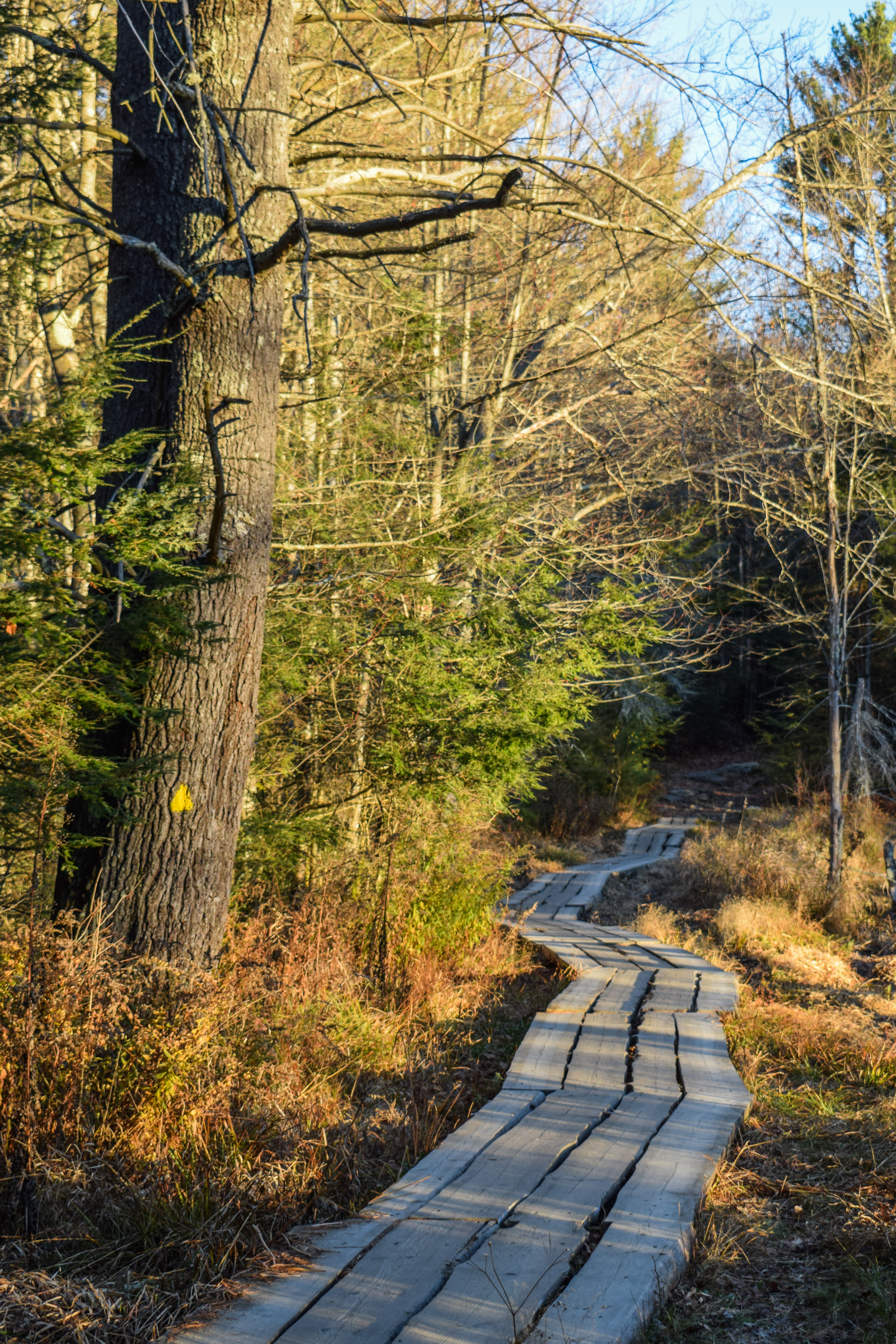
I started my journey on the Wapack Link Trail out of the parking lot, which in hindsight added some mileage to my day (I could have road walked up to the actual WT, but brain was running on low. The trail walks into the woods, passes a signed junction to "Flat Mountain" (not listed anywhere or on AllTrails), and then dips into a very wet and muddy sag which made me grateful for my new waterproof boots! No more than 3 minutes in I heard the thunderous roar of a grouse. The trail was littered with sticks and logs, assumedly there to help the mud crossing. Soon enough it climbs again to terminate at the true Wapack Trail.


From here, I turned right to hike the Wapack Trail from this junction to Turnpike Road. The trail conditions continued to be wet and muddy, but the trail opened up to what looked like an old abandoned rope-tow ski hill! There was some old equipment along the lift line, and a private residence on the other side (I later learned it was sometimes called Kidder Mountain or Flat Mountain Ski Area - https://www.nelsap.org/nh/kidder.html). It looked like the Flat Mountain trail could have saved some time, but there was no way for me to know. The trail continues to the bottom of the ski hill, through another very muddy spot, and then works its way to Turnpike Road, which was my turn around point.


Back at the original junction, I continued along the Wapack Trail, which skirted a recently logged area followed by a wide power cut, where the Kidder Mountain Trail turns right. The fog was lifting, but the tops of the power lines were still hidden from view. 


Following the power cut, the Wapack Trail followed a stone wall alongside a more heavily logged area that appeared to be in the beginning stages of development that was HEAVILY posted as "NO TRESSPASSING." The trail spits you out onto a wide dirt road that appeared to be recently widened. Walking here felt very wrong, but there was still an occasional blaze, so I continued on!


The trail crossed a drained pond and continued onto another, smaller, more scenic dirt road. Finally, the Wapack Trail veers left when the dirt road turns right and enters an old, decomissioned woods road, called "Old Road" on AllTrails. Old Road was wet, sometimes acting as a lovely stream, sometimes as a bottomless pit of mud. Later, the stream veers off of the road and the trail becomes lovely. I heard another grouse "drumming" off in the distance, which I only recently learned was the sound of my "favorite" bird!


There is an easy, swampy crossing at a small, open area, and then the trail becomes muddy again, with the trail meandering off the flooded roadbed. The end of this section is marked by a lovely, easy rock hop on comically large, flat rocks in mossy woods. This section of trail ends at the intersection of Nashua Road and Temple Road, and then continues along the paved Temple Road, which travels past a few very different houses, ranging from lovely surburban properties to collections of motor homes, most of which seeming abandoned? The temperature was beginning to rise with a few rays of sunlight peeking through the clouds just as I arrived to the next trailhead, which is truly where my first climb of the day would happen.


There were two cars at the trailhead, which implied my long day of solitude was soon to end, but that was okay. The trail sign said it would 4.8 miles to NH-101, meaning that it would be a while until I am standing back at this point. I forced myself to get out of my head and started climbing!


The climb was mostly moderate, lined with, you guessed it, more stone walls! The upper forest was beautifully covered in moss and lichen, and soon enough I was at the first of two outlooks overlooking Mt. Watatic and Barrett Mountain - a lovely break spot, but I wanted to push on a little further before I had a good sit. 


The sweat was definitely present as the trail continued to climb, much more gently at this point, and the pimple on my waistline was really starting to bother me, but the smell of the woods kept me going. I ran into my first people of the day 4.5 miles into my hike (1 hour and 53 minutes) - I was happy with that! A few cairns started to appear in more open areas, and the trail began to dip into a blowdown area and then crossed into a different property.


The Wapack Trail continued it's wiggle along this ridge, named the "Cabot Skyline," passed the Berry Pasture Trail, climbed a bit more moderately to a spur with a great standing view of Mt. Monadnock, which is where I took my first big break. I had another breakfast sandwich that I stashed away as the sun turned the sweat on my back into steam while I admired Mt. Monadnock through the tall saplings. 


After 15 or so minutes, I packed up my belongings, got what I thought would be one final glance of Mt. Monadock, and continued my hike not too far to the first named peak of the day, Burton Peak. After the peak the trail leaves the Cabot Skyline cooridoor and provides more obstructed, season views of Mt. Monadnock through young trees behind a stone wall. There was a signed outlook with not much more to see than some snow at the bottom of a cliff, and another great view of Mt. Monadnock just a bit further down trail.


After that view, the woods thickened and some flies began to awaken from their winter slumber. The Wapack Trail dipped and continued toward Holt Peak, which looked like a shadow in the distance through the trees. The trail yet again dipped, crossed an open area with a chair-like cairn, and then climbed more steeply up to Holt Peak, which was marked by a sign, and two off-trail cairns that I am still confused about. 


Now, continuing forward, the looming shadow was of Pack Monadnock. I tried not to look forward too much, but I also reminded myself I'm not climbing Pack Monadnock on this hike. There was a wild off-trail collection of cairns, and not too long after, a stone-living-room-type area as well. I was shocked and delighted at how sunny the trail has become!


Finally, the trail entered New Hampshrie State Land and passed near a communication tower, but I could hear someone working, so I stayed on-trail to mind my business. After this, the trail descends slightly and turns onto the access toad for Temple Mountain, my second abandoned ski area for the day! 


New England Lost Ski Areas Project: https://www.nelsap.org/nh/templemtn.html
New England Ski History: https://www.newenglandskihistory.com/NewHampshire/templemtn.php

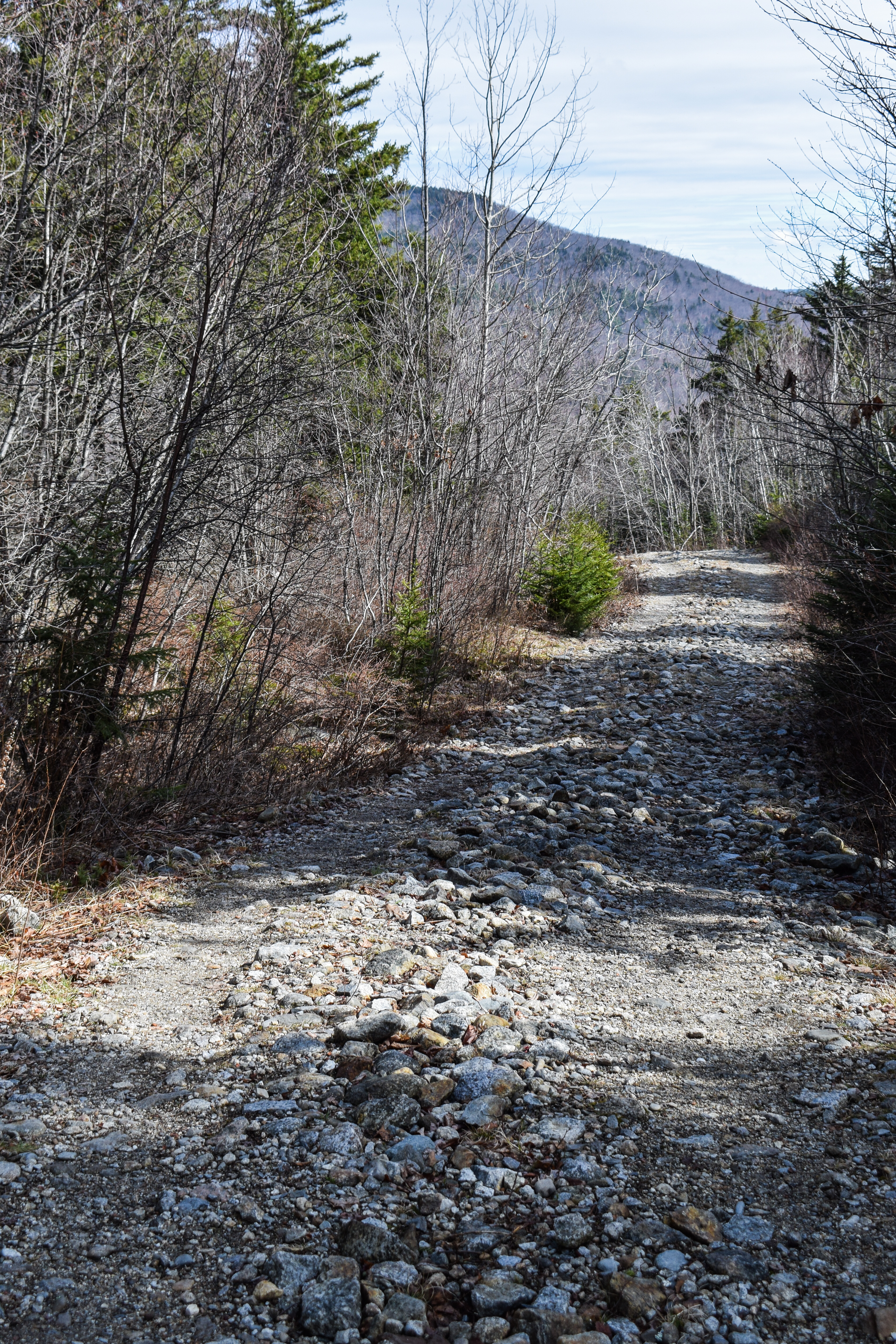
The footing on the access road was relatively brutal, but there was a nice view of Pack Monadnock up high. There was a signed overlook, but I could not find a significant view and refused to add any more miles than necessary, since I still had to turn around and hike everything again!


Continuing down the access road, I had the distinct pleasure of YET AGAIN running into TWO grouses - at least I gaught a climpse of these monsters (after jumping out of my skin, naturally). The access road continued a gradual descent past and old(?) storage garage and soon enough came to a spot where the Wapack Trail turned left off the access road to follow a short spur trail to NH-101, which was an underhwelming as it sounds. My turn around moment was at 8.18 miles and 3 hours and 44 minutes. 


On my first uphill climb, back up the access road, I downed a bag of pistachios and was passed by the communication tower worker, who was driving downhill in his massive truck. To put it lightly, the climb sucked. Just long enough to where I was approaching miserable, and naturally, the steepest part is right before the top. I saw one person near the top with his unleashed dogs, and I took a small detour off the Wapack Trail to snoop around the communication tower area, which was also the top of the old ski area. 


The spur returning back to the Wapack Trail was heavily hidden by trees. The clouds rolled back in and I could see the high point of Holt Peak, which provided a feeling of impending demise (I fear I may also have been dramatic at this time). I was definitely feeling tired at this point, and really the only activity I had keeping me going was finding the town line markers along the mountain's ridge (most were tall, narrow stones). 

I eventually passed someone who appeared to be a thru hiker with his dog near the first peak, re-entered the Cabot Skyline cooridoor, and I stopped at the same snack spot for another sitting break. I truly love any and all views of Mt. Monadnock. It felt like it was so late in the day, but it was only 11:45am, which was a needed confidence boost!


After my break I began to pass more and more people, enjoyed the second of the first two views, and comically passed a man hiking up hill who yelled "HEH" in an exasperated voice at me when I asked how his day was going. 

Soon enough I was back down on Temple Road and the hardest substance on earth, pavement on tired feet. Thankfully this bit of "trail" went more quickly and I was soon enough back on "Old Road." There was one car parked at the Old Road/Temple Road junction, which turned out to be a trail runner (which was impressive considering the mud). 


I could hear chainsaws through the woods which turned out to be the last house on the dirt road (right at the southern end of Old Road) doing yard work. The final uphill stretch on Old Road was emotionally brutal but physically fine, and then I was back on the dirt roads mindlessly walking back to the power cut. Almost there!

Back at the power cut, I was able to fully enjoy the views it offered - which included a distant view to Mt. Greylock! I never get to see Greylock from my hikes, so this was a fun treat. I passed a family near the Wapack Link junction where the older sister (no more than 8) was teaching the younger sister (no more than 5) how to hike properly, including foot technique and human contact etiquette, which was actually lovely to watch. Soon enough, I was trudging throught the mud and made it back to my car! A long hike, but a good one! I'm glad I did this hike third so my final Wapack Hike will be slightly less uneventful. And now... sleep!


Step-By-Step
- Start hike at Wapack parking area off of Temple Road.
- Follow Wapack Link.
- At terminus, turn right onto Wapack Trail southbound.
- At Turnpike Road, turn around. 
- Hike Wapack Trail northbound to Peterborough Gap (NH-101).
- Retrace steps to car.


"Wapack Trail" from Southern New Hampshire Trail Guide, 5th Ed. (2021)
        Section II. Pratt Mtn. to Barrett Mtn. [...]. Trailhead parking is available in a new parking area (sign: "Wapack Parking") across the highway from the entrance to Windblown (the former roadside parking area has now been posted no parking and hikers are not permitted to park on Windblown property). From this new parking area, a new connector trail, Wapack Link, ascends easily for 0.3 mi. to meet Wapack Trail. At Wapack Rd. the trail crosses NH 123/124; use caution on this busy road.
        Section III. Kidder Mtn. Wapack Trail next crosses the lower western slopes of Kidder Mtn. (1,816 ft.). From the north side of NH 123/124, the trail follows Old Rindge Rd. for several yards, quickly bears left into the woods, passes close to a private residence, and then crosses an open field, site of a former downhill ski area. At 10.1 mi. Wapack Trail turns left on an old grassy road bordered by stone walls and crosses under a power line 150 yd. beyond. Here, blue-blazed Kidder Mtn. Trail (described below) diverges right, leading 0.9 mi. to the open summit of Kidder Mtn. Meanwhile, Wapack Trail descends to a junction with a gravel road from the left at a pond on the right. Here, the trail turns right onto a woods road, crosses a pond outlet, and ascends gradually to the Wildcat Hill - Conant Hill saddle, where there is an old homestead site to the right. The route descends gradually, still on the old woods road, and crosses the outlet of a beaver pond on the right. It then bears left where Todd Rd. diverges right at 11.4 mi. and continues to Nashua Rd. (the road from Temple to Jaffrey at 11.8 mi.
        Section IV. Temple Mtn. Wapack Trail crosses Nashua Rd. and continues straight ahead along Temple Rd. 0.4 mi., bears right at a fork where Greenleaf Rd. diverges left, and then turns right in 30 yd. to begin climbing the south ridge of Temple Mtn. Trailhead parking is available 0.3 mi. from NH 123 via Greenleaf Rd. at the Belletette parking area, across the street from where the trail leaves Temple Rd. From this point north, Wapack Trail passes through private conservation land managed by the New England Forestry Foundation. Please observe the posted rules about no fires and no smoking.
        The trail ascends moderately up the south end of Temple Mtn., which boasts several summits. This part of the trail has been named the Cabot Skyline in honor of longtime conservationist (and past AMC president) Tom Cabot. At 12.6 mi. a side path (sign) descends 40 yd. to Roger Myrick Outlook on the Sharon Ledges, with a view southeast and south. The grade eases on the main trail, and at 12.7 mi. another side path leads 40 yd. right to a southeast outlook. At 13.5 mi. blue-blazed Berry Pasture Trail (FOW) leaves left and descends 0.9 mi. and 750 ft. through blueberry pastures and down an old woods road. It ends at Mountain Rd., 0.6 mi. northeast of the Sharon Arts Center on NH 123. (About halfway down this trail, views west were opened with a large clear-cut during a timber harvest.) Wapack Trail, however, ascends steadily to Burton Peak (2,014 ft.) at 13.6 mi., where a short, blue-blazed loop trail on the left leads past good views west (also opened by the timber harvest). From here north, stone monuments mark the Sharon-Temple town line, which also follows this ridge.
        Wapack Trail continues north along the ridge, crossing a knob with views east and west at 14.0 mi. It descends to a saddle and then ascends steeply to wooded and viewless Holt Peak (2,059 ft.), the highest point on Temple Mtn., at 14.6 mi. (A side path on the left leads to the true summit.) The trail descends to a col and then ascends easily to the Temple Mtn. Ledges at 15.1 mi., where there are cairns and views to the left. The trail once again descends and then ascends easily, passing just to the west of Temple Mtn.'s north summit. Wapack Trail then swings left past a communications tower on the right. At 15.7 mi., 50 yd beyond the tower, white-blazed Beebe Trail joins from the right, making a loop hike possible from NH 101.
        Wapack Trail descends along the tower-access dirt road through the former Temple Mtn. Ski Area (now part of Temple Mtn. State Reservation), with views of Pack Monadnock from ski trail openings. At 16.3 mi. a connecting path diverges right and descends 130 yd. to Beebe Trail.
        At the base of the descent through the former ski area, just before a steel gate and a right turn, Wapack Trail turns left off the access road. (The access road continues ahead 0.1 mi. to the lower terminus of Beebe Trail on the right and then another 80 yd. to a large parking area off NH 101 at the base of the old ski area, 0.1 mi. east of the entrance to Miller State Park. This is the best trailhead parking for Temple Mtn.) Wapack Trail passes through a brushy area and two gravel areas and reaches NH 101 in Peterborough Gap at 16.5 mi., a few yards east of the road up Pack Monadnock (Caution: Take extreme care when crossing NH 101, as sight distances are limited and automobile speeds are high.)