Appalachian Trail via South Ridge & Ambassador Whitehouse Trail (Sky Meadows State Park)
Hike Type: Lollipop Loop
Distance: 6.13 miles
Elevation: 1,112 feet
Time: 2 hours, 7 minutes
Hiking Challenges: N/A
Hiking Challenges: N/A
The Hike
I was in Virginia for a friend's wedding and had a few hours to kill, so naturally I found a state park and went on a little adventure! I dropped the bridesmaids off at the wedding venue in the morning, unforunately had to drive to a Walmart to buy socks (oops), and then I was off! It was a cloudy day, but no rain was in the forecast. When I pulled into Sky Meadows State Park, I paid the $10 fee and parked on a grassy lot near the Historic Area (the woman at the entry gate said "you'll know where to park when you're there" - she was right). The park was relatively busy, but it was late morning on a decently nice Saturday. I parked just after 11 and got myself ready for my adventure! It was 74 degrees, humid, and very buggy (it was wild being back in summer when I've been fully enjoying New England fall!).

"Sky Meadows State Park"
https://www.dcr.virginia.gov/state-parks/sky-meadows
Rich in history, this park provides recreational offerings that engage visitors and help connect them with farming practices that formed its unique pastoral landscape. This 1,860-acre park has scenic views, woodlands and the rolling pastures of a historic farm that captures the colonial through modern life of the Crooked Run Valley. Nature and history programs are offered year-round. Hiking, picnicking, fishing and primitive hike-in camping for families and groups are favorite activities in this peaceful getaway on the eastern side of the Blue Ridge Mountains. The park has 10.5 miles of bridle trails, 22 miles of hiking trails, 9 miles of bike trails and Appalachian Trail access.

I found a loop on AllTrails that linked with the Appalachian Trail (we were north of Shenandoah National Park) through the "Blue Ridge Backcountry" section of the state park, so that became my goal. I walked along the remainder of the road before getting to the actual trailhead, and had to stop at the bathrooms (real bathrooms and porta-potties) on the way. The main Historic Area has a cute little homestead with farmlands surrounding - it was really pretty!

"History Gone Wild at Sky Meadow State Park: Boston Mill Road"
https://www.dcr.virginia.gov/state-parks/document/SK-History-Gone-Wild-Handout-Info.pdf
As you walk along what is today Boston Mill Road Trail, imagine it as it once was, a thriving corridor, along which farmers would transport harvested grains and crops to the nearby mills, and to the town of Paris. Established in 1823, the road was named after nearby Bosetyn’s Mill.
"Boston Mill Road Trail"
from trailside kiosk.
Imagine farmers transporting harvested crops along this cooridoor, once the Boston Mill Road, established in 1823. The road, named after Bosetyn's Mill, connected the village of Paris and surrounding farms to the local mills in this valley, the Crooked Run Valley.

Now continuing along the road toward the trails, I noticed the upper ridge was still in the clouds - what else is new! Soon enough, I turned left onto the first "trail" (farm road), the green-blazed and memorably-named Boston Hill Road. Boston Hill Road was a beautiful road lined with trees and covered with Eastern Black Walnuts. There were lovely views out to the surrounding farmland and forward on the undulating road. I made an executive decision to take the planned loop in reverse due to a large party going the way AllTrails suggested (AllTrails suggested counter-clockwise, I decided to go clockwise).

"Restoring the American Chestnut"
from trailside kiosk.
For thousands of years the American Chestnut was the most dominant tree in a forest that stretched from Florida to Maine and from the Ohio Valley to the Carolina Piedmont. Imagine a wooded landscape in which one of every four trees could grow to more than 10 feet across and well over 100 feet tall.
The American chestnut tree was a particularly useful tree. Native people made use of the nuts as a food staple and bark and roots to make medicine.
European settlers used the light, strong, rot resistant wood for cribs to coffins and about everything in between and the nuts were not only a valuable livestock food but were often gathered by the wagonload and sold by street vendors freshly roasted. The chestnuts were also a primary food source for wildlife such as turkey, squirrels, bear and deer.
In 1904 an asiatic fungus known as the Chestnut Blight (Cryphonectria parasitica) was identified in New York's Bronx Zoo. By 1950 the chestnut blight had spread across the entire native range, killing an estimated 4 billion chestnut trees. The blight kills the tree by feeding on the cambium under the bark restricting the flow of nutrients within the tree.
In 1983 the American Chestnut Foundation was founded with the mission to restore the American Chestnut. Blight resistant hybrids have been grown that are 93.75% American Chestnut and 6.25% Chinese Chestnut. Sky Meadows State Park has joined with ACF and planned 4 acres of these trees in the park, giving hope that one day we can walk among these giants again. For more information or to become involved, visit: acf.org/va.
The trail signs were large posts in the ground with color-coded plaques indicating where certain trails were. There were a couple informational kiosks along the road, and I was delighted to discover that the bugs were only bad when I stopped moving. At a low-point in the road, I turned right onto my new temporary home, the South Ridge Trail.

"Natural Buffer"
from trailside kiosk.
The streamside trees before you are some of the hardest working plants in the park. In 2009 park staff and volunteers planted over 8,000 native trees consisting of hickory, walnut, beech, poplar; and different species of oak. This barrier of natural vegetation between the pasture and Gap Run, a tributary of the Chesepeake Bay, is a riparian buffer. This natural barrier keeps agricultural waste from pollution the stream and, ultimately, the Bay by blocking and absorbing animal waste, pesticides, herbicides, sediments, and excessive nutrients. The buffer also provides shelter and food for wildlife. Its shade keeps the water cool, promoting more aquatic wildlife.
All park waterways are now protected, but at a cost. Farmland is reduced by 28 acres, descreasing food production. The future holds many of these difficult decision for us and our farmers.
For all these efforts, Sky Meadows State Park received the 2010 John Marshall Soil and Water Conservation District Award.
Relocation of fence lines separated cattle from their natural drinking source. To resolve this, the Department of Corrections' Agribusiness Program, which manages the park's cattle and haying operations, partnered in this project by installing wells, pipes, and troughs to supply water for the cows.
The wide road grade continued through a flowery meadow before turning again onto a smaller road, still covered in walnuts. Here is where I passed the first and only people of this stretch of the hike - it appeared that I had left the majority of folks back at the main area, which was a delight.

The South Ridge Trail entered the woods temporarily and began to climb at easy to moderate grades through lush vegetation going through various stages of reforestation. I more or less power hiked through this stretch in order to get ahead of the group behind me, so I was SWEATING. I know fall had only just begun in New England, but I forgot how intense this humidity felt!

A couple of switchbacks led to a great overlook of the Historic Area, not to be confused with the "Historic Area Overlook," which was just a bit further up trail off of a spur path (worth a visit, too!). I noticed a very blue berry (not a blueberry, though), that apparealy grows on the mile-a-minute weed, which was fun to see.

The next landmark was the Snowden Ruins - some stone foundations just off-trail. There's a neat Washington Post Article about the site from 2003.

"History Gone Wild at Sky Meadows State Park: Snowden Entrance Gate"
https://www.dcr.virginia.gov/state-parks/document/SK-History-Gone-Wild-Handout-Info.pdf
Here we can see the remnants of the entrance gate to the Snowden Manor. If it were still standing
today, Snowden would be the oldest structure in that park. However, today it exists only in ruins. The
Snowden farm, established by George Ayre, once incorporated approximately 500 acres. The home
burned down in 1931. You may explore the Snowden ruins for yourself along South Ridge Trail.
Continuing to follow the South Ridge Trail, which was now back on a wide road, past some bear poop, I arrived at an open grassy, flowery meadow where the George's Overlook spur trail branches off.

The George's Overlook spur was a less-traveled wide-mowed pathway through the grassy meadow. The path was super pretty, winding around the grasses and flowers, eventually opening up to an overlook area. I also noticed that the sun and sky were beginning to come out!


Once back on the South Ridge Trail, the climbing continued with good footing and a mostly open canopy. I was really enjoying my time outside in relative solitude, and to no surprise, I was also glad that I decided to make the drive instead of sitting in the hotel room all day. I hit the two-mile mark at 42 minutes and realized that I was cruising. The grades here are similar to those of the Castle in the Clouds Conservation Area in the Ossipee Mountains of New Hampshire, which allow for big miles with only medium exertion. After this two-mile mark, the South Ridge Trail begins to gradually enter the forest, ascend to a bench, and then continues along a nice walking break.

I passed the largest gray squirrel that I had ever seen as the walking break continued, with just a few gentle ups and downs. I passed what appeared to be a burnt tree that was harboring at least 100 spotted lantern flies, which was wild to see (I'm so glad they haven't found their way to New England yet).

Shortly after the lantern fly tree, the South Ridge Trail terminates at the North Ridge Trail, which followed a footpath more steeply to the actual ridge. I crossed paths with two larger groups, noticed the clear blue skies above, and soon made it to the Appalachian Trail! I was soaked in sweat, but there was a delightful breeze. I was so pleasantly surprised with my adventure so far.

I continued my hike on the Appalachian Trail northbound, past some truly gigantic trees, and came up to a gate and a beautiful meadow. I'm guessing the gate is a property boundary, as it truly was not blocking anything. Up here, I truly understood how the name "Sky Meadows" came to be - it was beautiful! The sensational breeze continued, as well.


After the first meadow, the AT dipped back into the woods, where I passed a group discussing the politics of the Supreme Court (the first of many political conversations I overheard - that's what I get for being relatively close to DC!). I crossed paths with a few more groups as the trail easily descended into a much larger meadow-y area with beautiful views into the Virginia Piedmont valley.
I turned onto the Ambassador Whitehouse Trail, which followed a mowed path through the beautiful meadows. There were partial views but the area was wide open - still really beautiful. Only downside was that I had officially found all of the Spotted Lanterflies. You could really see little red specks flying all around the meadow, some of which enjoyed gently flying onto my body, which I did NOT like. I did enjoy stomping on the ones crawling on the ground, though!

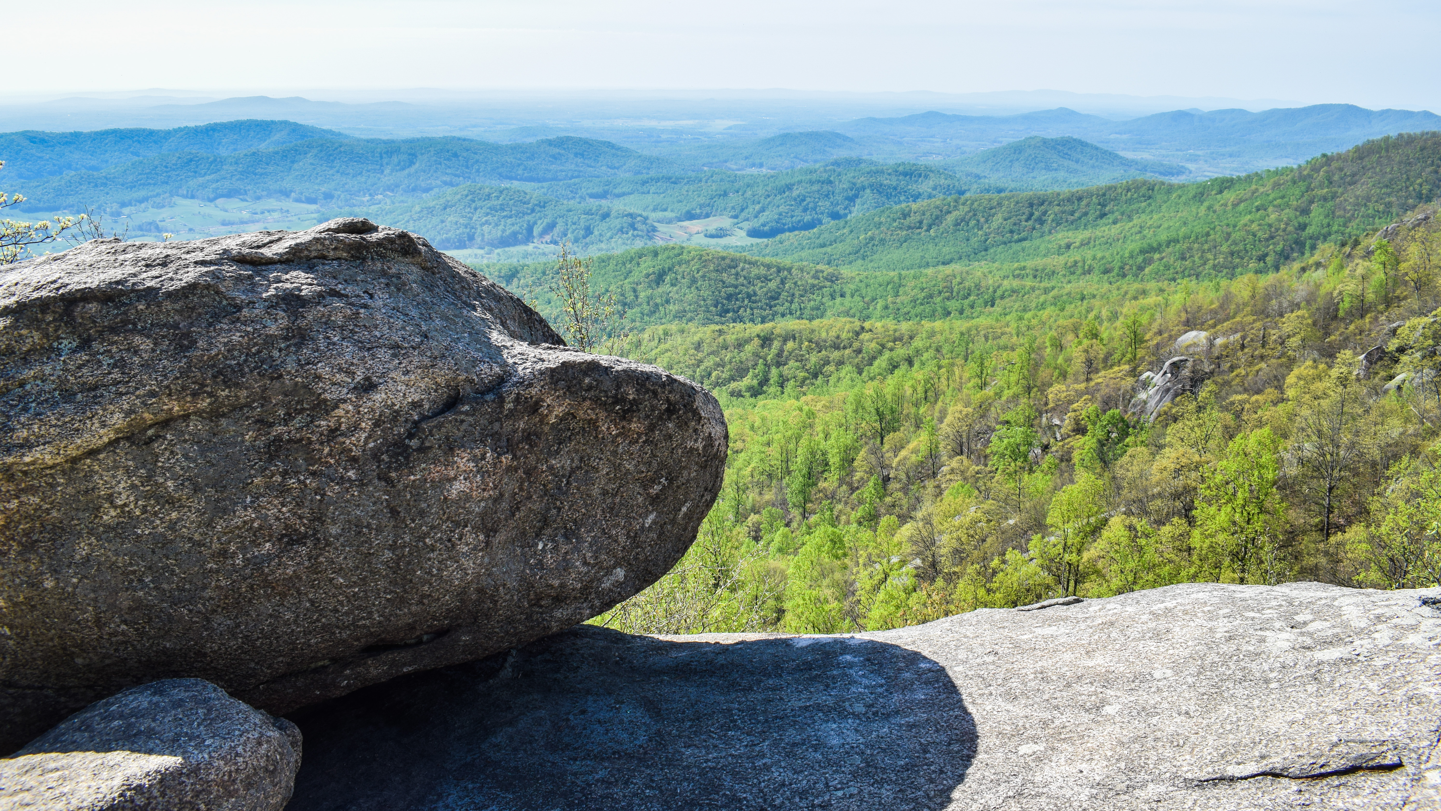
The Paris View/Piedmont Overlook was at a turn in the trail, which provided a beautiful view down into the valley, albeit hazy. More Lanternflies were enjoying this view, so I didn't stay too long.

"Welcome to the Piedmont Memorial Overlook"
from view kiosk.
You are looking out at the heart of the northern Virginia Piedmont, a verdant agricultural landscape stretching 17 miles between the Bull Run Mountains to the east and the Blue Ridge Mountains to the west, where you are now standing here in Fauquier County. To the south lies the Crooked Run Valley, extending toward Delaplane. To the north lies Clarke and Loudoun counties.
The rolling green hills of field and forest, dotted by historic towns and villages, and criss-crossed by gravel roads have earned the area a well-deserved reputation for its scenic beauty and historic significance, from pre-colonial times to European settlement, through the Civil War and development of moderan agriculture.
This view is no accident. For decades, private landowners have worked together with land trusts to permanently protect their property. The result is one of the largest blocks of conservation easements found anywhere in the eastern United States, ensuring that future generations will enjoy the benefits of clean air and clean water, local food, wildlife habitat, and abundant natural, scenic, and cultural resources.
The Overlook sits on top of Paris Mountain. Several freshwater springs can be found on this property which feed Gap Run, a mountain stream that flows into Goose Creek, a source of public drinking water for northern Virginia residents and an important tributary to the Potomac River.
This mountain is also part of the Crooked Run Valley Rural Historic District, which includes Ashby Gap, a historically important route to the Shenandoah Valley along what is now Rt. 50/Rt. 17.
The Preservation Alliance of Virginia once nominated the view from Ashby Gap toward Paris as one of the most endangered, calling it "the quintessential Virginia vista."

"A Demonstration of Habitat Restoration"
from view kiosk.
The Piedmont Memorial Overlook sits within a large block of privately and publicly protected land along the Blue Ridge Mountains that is a patchwork of forest, livestock pasture and mountainous fields. The land was actively farmed from the late 18th century until the recent past, and heavily grazed by cattle.
In 2012, The Piedmont Environmental Council began an extensive restoration effort on the 50-acre parcel you are standing on, first eliminating fescue and other non-native plants from the pasture, and then seeding native grasses and wildflowers. The property now serves as an active demonstration site for landowners who are interested in viewing habitat restoration practices. It hosts a native meadow, tree and shrub plantings, and a small pine savannah.
Grasslands are declining worldwide, and are one of the most endangered ecosystems on the planet. In Virginia, native grassland is being lost to land use changes like development, farming, and forest regeneration. Grassland dependent bird species are also declining rapidly as their habitat is lost. Restored meadows, like the one at the Overlook, offer refuge for these species in a changing landscape.
The native meadow is the jewel of the property, and is home to songbirds, butterflies, raptors, bees, and black bears. It was planted with 16 native wildflower species that provide forage for pollinators and habitat for grassland birds.
PEC manages teh meadow using prescribed fire and routinely performs biodiversity surveys with out partners at Virginia Working Landscapes, a program of the Smithsonian Conservation Biology Institute.
Learn more at www.pecva.org/overlook.

"A Conservation Success Story"
from view kiosk.
The Piedmont Memorial Overlook sits on 50 acres owned by the Piedmonst Environmental Council, and is part of a corridor of the Blue Ridge Mountains that is permanently protected by Sky Meadows State Park, the G. Richard Thompson Wildlife Management Area, teh Appalachian National Scenic Trail, and private land under conservation easement.
In the late 1900s, this property and surrounding area was threatened by several development projects, including mountaisde housing developments and a proposed golf course. Fortunately, in 2000, PEC was able to purchase 1,235 acres with assistance from local families and foundations who support conservation in the Piedmont, including the Prince Charitable Trusts, Jacqueline B. Mars, Catherine Mellon Conover, Marie Ridder, the Ohrstrom family, the Mills family, the Whitehouse family, the Frout family, Phillip and Patricia Thomas, and many more.
Soon after purchasing the land, nearly 450 acres were transferred to the United States Department of the Interior to realign and improve the Appalachian National Scenic Trail and provide public access to this exceptional viewshed thanks to the vision and leadership of then Virginia Senator John Warner and Congressman Frank Wolf.
Over the past decade The Piedmont Environmental Council has protected nearly all of the 1,235 acres purchased in 2000, and now retains this 50-acre holding on top of Paris Mountain.
The Piedmont Memorial Overlook is now a place of reflection, where we can remember community members who spent their lives working to protect this landscape. This memorial site, conceived by William M. Backer and supported by The Piedmont Foundation, is dedicated to those friends and supporters!

"About the Piedmont Environmental Council"
from view kiosk.
Since 1972, the Piedmont Environmental Council has worked to promote and protect the natural resources, rural economy, history and beauty of the Virginia Piedmont.
As a grassroots nonprofit organization, we work hand-in-hand with local residents to conserve what they care about and improve quality of life. Rather than leave change to chance, we believe that citizens have the power to shape the future of this region for the better.
This property is a demonstration of that commitment. We hope you enjoy your visit to the Piedmont Memorial Overlook and come back often!
PEC's service territory includes nine counties and one city in the northern Piedmont of Virginia. In addition to statewide and federal policy works, we also serve as fiscal sponsor of the Coalition for Smarter Growth, an organization that focuses on land use and policy in the greater Washington D.C. area.
After the view, the trail continued back into the woods and descended more moderately to its terminus at the North Ridge Trail (I also passed a family in a deep discussion about animal poop, which made me giggle).

I followed the North Ridge Trail again for just a moment, and then I turned onto the Piedmont Overlook Trail, which initially ascended again to a stunning open meadow. I crushed some more Lanternflies and saw the group that I passed early on in the hike - fun! The view here was panoramic, and I could see my car! I was very grateful for the breeze.


From here, the trail moderately descended through the beautiful, view-filled open meadow. I passed a backpacking group with all matching gear (I assume they were renting, in a non-deragatory way). I was missing my good socks on this descent, as I could feel every step, but I was surviving okay.

The trail crossed another gate down low, went over a bridge, and then terminated back on Boston Mill Road. I was back on the pavement just over two hours after starting my hike, and I was thrilled with my little adventure! I stopped back at the bathroom and then went into the gift shop, where I treated myself to an ice cream sandwich! It was like a whole new park down here without all of the clouds.

Epilogue...
Another fun post-hike adventure... After my ice cream, I got lunch at Sheetz, showered, and took a lovely nap! When I woke up, I had a little headache so I took three Advil - two for the headache and a third for "later" (I planned to have fun and wanted to prepare!). I then had a Celcius (200mg caffeine). When I was almost done with the Celcius, I noticed that my Advil didn't actually say "Advil." It didn't even say "Ibuprofen" - it said "Sleeping Aid." I had a brief panic, and then I simply had to accept that it would be a weird night... (Note: I have been taking these not-Advils as Advil for the past month as needed, and the bottle lived in my car...). I think I watched the wedding ceremony from the etherial plane. I could feel the atoms in my body vibrating. It was WILD. After a few drinks and dinner, I began to turn normal again, but man, I felt insane.
Step-By-Step
- Park at Sky Meadows State Park main parking area (Historical Area).
- Start hike toward Boston Mill Road.
- Turn left onto Boston Mill Road (green).
- At third junction, turn right onto South Ridge Trail (yellow).
- Hike spurs to Historic Area Overlook, Snowden Ruins, and George's Overlook.
- At terminus, turn left onto North Ridge Trail (blue).
- At terminus, turn right onto Appalachian Trail (white).
- At second jct., turn right onto Ambassador Whitehouse Trail (light blue).
- At terminus, turn left onto North Ridge Trail (blue).
- At next jct., turn right onto Piedmont Overlook Trail (red).
- At terminus, turn right onto Boston Mill Road (green).
- Return to car.