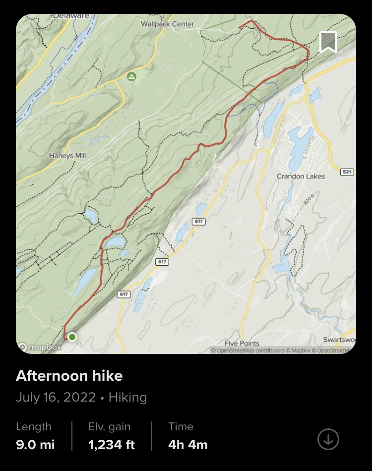
Appalachian Trail: Culver's Gap to Stony Brook Trail (Stokes State Forest)
Distance: 5.58 miles
Elevation: 820 feet
Time: 2 hours, 21 minutes
Hiking Challenges: New Jersey Appalachian Trail; 52 Hike Challenge

This is the final hike I needed to complete the NJ section of the Appalachian Trail, and naturally I started the day by procrastinating. I made my way to the Culvers Gap parking lot, but it was misting out so I decided to drive to the lookout on Sunrise Mountain first to kill some time which was lovely. When I made it back to the parking lot (30 minutes later), it was still misting but I decided to get ready. I was then approached by a thru-hiker who hammock camped next to the parking lot and he asked for a ride to Sunrise Mountain, which I agreed to. He packed up for about 15 minutes and then off we went! I learned that his name was Max, he was from Arkansas, he's been on the trail since April, his trail name was either Fisher or Fisherman, he didn't make it to the shelter last night because he enjoyed a cheeseburger for a little too long, he might go to Acadia after summiting Katahdin, and that he needed the ride to Sunrise Mountain so he could get ahead and meet his friend at High Point. I decided to not be prying and ask if he'd go back for this section, a mystery! Eventually I made my way back to the parking lot, used the horrible porta-potty, and actually got my hike started.

There is a short section of trail that connects the parking lot back with Sunrise Mountain Road, and in there I passed a hiker who had hammock camped there last night. He was barefoot and smoking a cigarette, and about 30 feet away was his bear bag on the ground attached to a limb that looked like it had just fallen. Very interesting start to the day. I crossed Sunrise Mountain Road and then the trail started to climb steadily and moderately. Some sections were rooty and eroded and others mimicked the classic rocky trail I've grown to know so well. The climb was incredibly humid, with some drizzling and cloudiness. Very scenic regardless of how wet I was (at least it wasn't just my sweat this time!). My favorite part of this section was the incredible amount of red efts all around! Some as small as just over an inch. I was nervous to step on them! I also saw the world's smallest frog during my climb.

There is one wide switchback during the climb which opens to a lovely view of the end of Culver's Lake and the surrounding hills. After the view, the trail levels out and meanders through some lovely woods. The switchback did throw off my brain and I got nervous I was hiking in the wrong direction, but thankfully I figured it out. Just before the lookout tower there is an unmarked trail to what I believe to be a radio tower (which I first thought was someone's residence - the tower is not on the NJDEP map, but it is marked on the NYNJTC map. On AllTrails, it's marked as Normanook Lookout Tower, which I believe is incorrect. The ridge in this area is known as Culvers Ridge, but apparently was formerly known as Normanook. I have more research to do). ANYWAY, opposite of the unmarked trail to the radio tower is another unmarked trail to a great view. I didn't see the mama deer staring at me 10 feet away which startled me, but thankfully she wasn't too bothered. I greeted her and politely asked to walk past, and she obliged. There was a fawn another 10 feet away that I also didn't notice. The path to the view was overgrown and WET, so I came out rather soaked. Definitely worth it though.


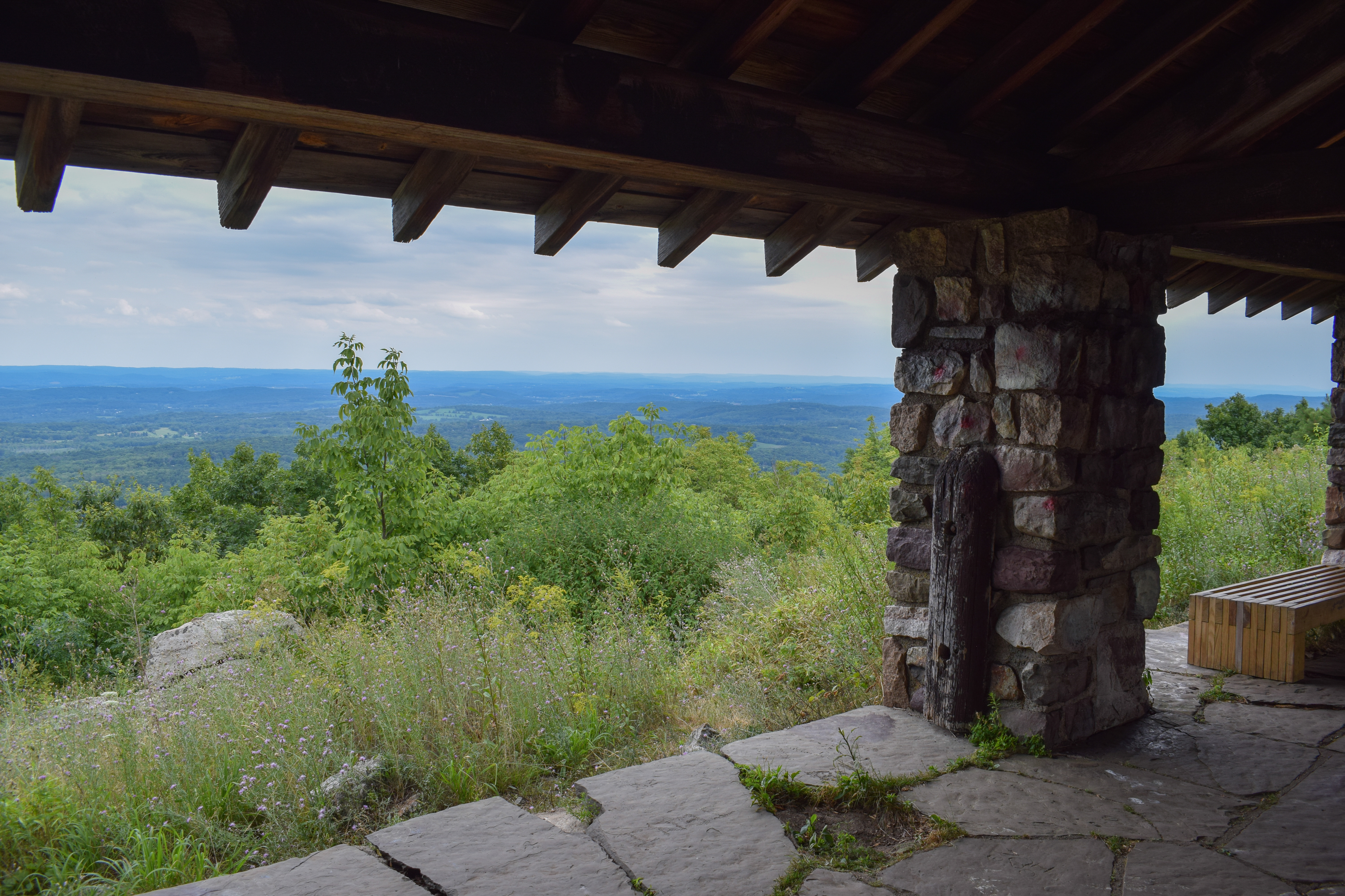
Soon after this view is the lookout tower area, which is absolutely gorgeous. There was a sign on the tower that said "no trespassing without permission" and a phone number, but I decided to just climb it and see what happens. Now called Culver Lookout Tower, it used to be known as Normanook Tower, and it was built in 1935 by the CCC. It was wet and slippery, so I took my time, and it was well worth it. The clouds were starting to burn off, and there was a great view of the ridge towards High Point, and the monument was just poking out of the clouds. Just beautiful! There were two trail runners that were at the tower area with me, and one asked if I got caught in the rain last night, insinuating that I'm at least section hiking. I chuckled and said "nope just from my car," but then I realized that one of two things would have triggered him to ask this question: I either looked like I had my life together and was a serious hiker, or I looked like an absolute exhausted mess - it will forever be a mystery!


The trail continues north towards Sunrise Mountain, and soon intersects with the Tower Trail that looks like another scenic area. The AT descended the ridge very gently into the land of more red efts, which was lovely. This was a younger area of forest with endless small, skinny trees. The pitter patter of the droplets falling off was equally peaceful and stressful as all hell. On one had it was visually beautiful and aurally soothing, but on the other hand the smallest bird could set off a train reaction of drops falling that sounds like a monster charging towards me.

My NJAT journey technically concluded at the junction with the Stony Brook Trail - hooray! I booped the brown blaze and had a celebratory beef stick, like any self respecting "civilized" hiker would. The return trip was quick and enjoyable. A gentle climb back to the firetower where someone was enjoying their lunch, more efts, and the clouds continuing to burn off. Just before the first view at the switchback I passed what was either a cub scout group or a summer camp group of ~15 kids that couldn't have been older than 10 with two adults/older teenagers. The kids were so excited about the firetower and multiple asked me how the view is, how cool it is, and how close they were. I usually get cranky with large groups, but this was wholesome as hell. After some more hiking I made it back to the car, changed out of my soaking wet clothes, and enjoyed my Wawa lunch from my new favorite place, the Augusta Wawa! Truly my only complaint from this hike was that my camera lens was constantly fogged up from the weather. I got home, had a snack, and ordered my patch!

- Park at Culvers Gap Parking Lot.
- Start hike on AT Northbound.
- Cross Sunrise Mountain Road, continue on AT Northbound.
- Enjoy Lookout Tower, continue on AT Northbound.
- Junction with green-blazed Tower Trail, continue on AT Northbound.
- Junction with brown-blazed Stony Brook Trail, turn around and retrace steps back to car.