Sunday, January 16, 2022

[BACKLOG] Hedgehog Mountain (White Mountain National Forest)

Hedgehog Mountain (White Mountain National Forest)

Hike Type: Lollipop Loop
Distance: 4.9 miles
Elevation: 1440 feet
Time: 2 hours, 47 minutes
Hiking Challenges: 52 With-a-View

Mt. Passaconaway, just past the summit of Hedgehog Mountain.

The Hike 

I'm going to preface this post by happily stating that this is the last of the 2022 backlog hikes I needed to write up. I've really enjoyed this journey of documenting my hikes in writing, and looking back at January through March to have those documented too. Now that I will be caught up with the original goal of this blog fully encompassing my 2022 hikes, I'm going to think about going further back to document some of my bigger and memorable adventures, and continuing my journaling into 2023. I also find it fun that this was on my first day of winter hiking, and I finished blogging about my most recent winter hikes too. Now, on to the hike!


We had about an hour drive from the Mt. Roberts parking area to the Hedgehog Mountain area, and the only eventful moment was when I got popcorn stuck in my teeth, then I got floss stuck in my teeth, ran out of extra floss to remove the stuck floss, and then had to stop at a convenience store on NH-16 to get more floss. I had been to the Hedgehog Mountain parking area when I hiked Potash last year, so I was excited to make my return. We arrived in the parking lot in the early afternoon, and made sure to have headlamps ready. 


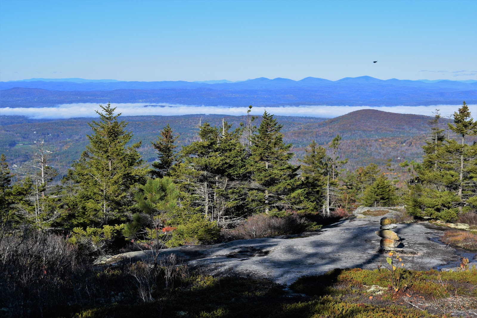
The hike started on the Downes Brook Trail, and quickly turned left onto UNH Trail from the parking area, following what appeared to be an old road. The trail had a couple inches of frozen snow on the ground, which our spikes gripped excellently. The trail continues by turning right off the straightaway and starts ascending, never too steeply. The whole loop is the UNH Trail, and at the next junction we continued straight instead of turning left to go over the summit first, and then hit the ledges. The woods were beautiful and peaceful - cold but windless. We took the side trip to Allen's Ledge, which had an excellent view of nearby peaks (I wish I had the guidebook with me because I can't seem to tell which peak ... I am writing this 11 months after the fact...). 


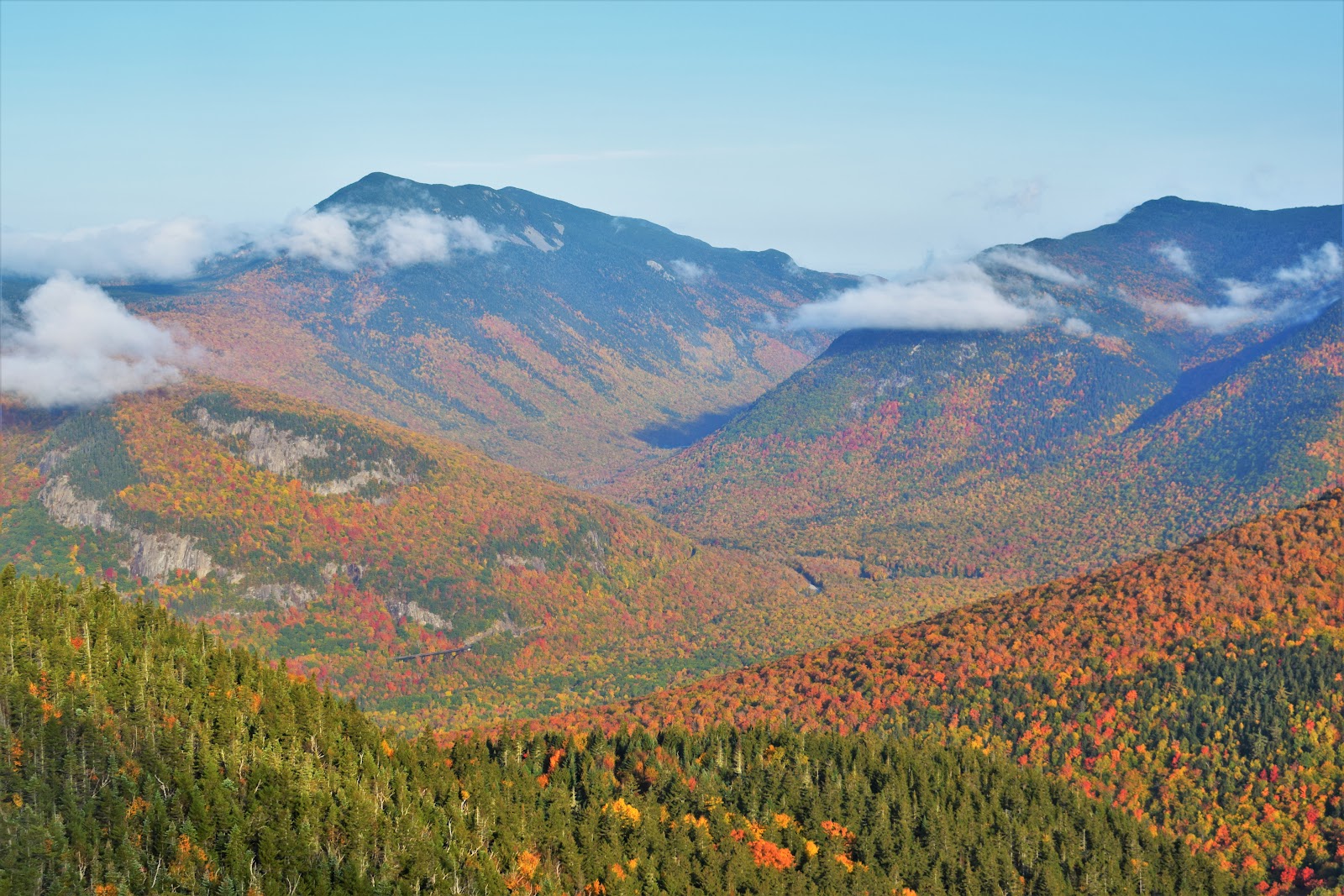
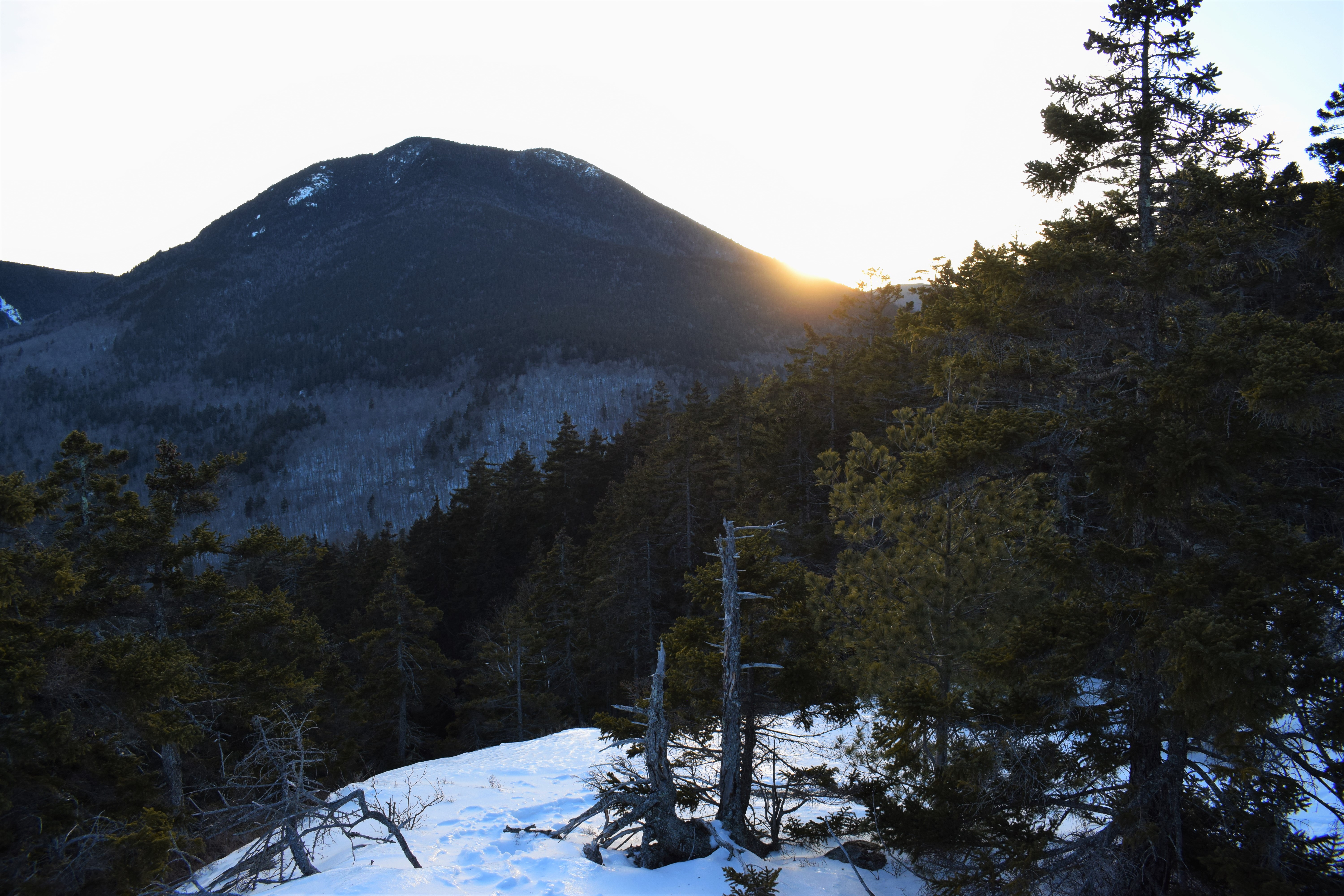
Back on the UNH Trail, we continued onward. Hitting the summit ledges just in time to see the sun setting behind the apparently massive Mt. Passaconaway. It was magical up here, and I saw the one, the only, Floki the cat! I was too starstruck to say anything, but it absolutely made my day. There were some more great views just below the summit and onto the east ledges, which were icy but easily gripped with spikes. The highlight of this view was the snow capped Mt. Chocorua, which I would hike in just a few more months. Behind us on the East Ledges was the upper stretch of Hedgehog Mountain, which was fun to see. 


Our final view of this hike was of the Moats (I think...), with sunset colors at the horizon and pale blue just above. The full moon had just risen over the mountains too, which was just a beautiful way to end this section of the hike. The final mile+ was significantly less glamorous, though. We continued on the longer stretch of the UNH Trail, where Gen had to stop and pee. That was the break that broke me. My body temperature dropped the second we stopped moving and I was shivering. I thought getting moving again would help, but it did not. Gen reminded me that I had mittens and my puff in my back (duh), and when I put those on my world was changed. Such an easy fix for such a potentially dangerous problem - amazing! When we hit that original straightaway it was officially headlamp time, and we safely made our way back to the car. Our day ended at the Mad River Tavern, which was just delicious.


Originally written December 19th, 2022 at 2:02pm.

[BACKLOG] Mt. Roberts (Ossipee Range)

Mt. Roberts (Ossipee Range)

Hike Type: Out-and-Back
Distance: 5.5 miles
Elevation: 1355 feet
Time: 2 hours, 56 minutes
Hiking Challenges: Ossipee 10; 52 Hike Challenge; Lakes Region Conservation Trust Explorer; Castle in the Clouds Achievement


The Hike

Gen and I set a goal to start winter hiking this year, and we finally had a day where the skies would be blue and no wind - so it was time! We watched a few webinars about winter hiking, since its something both of us had never done before outside of local hikes. We knew the goal was to adjust layers as needed and do our best to prevent sweat. We collected gear and layers, made hot chocolate for afterwards, and started our early morning COLD drive up to the Ossipees for hike #1: Mt. Roberts!


When we stopped at Hooksett, the thermometer read a balmy -7°, and the sun was beginning to show its morning colors beneath the horizon. We were confident in our layering systems, but still talked about how we can turn back at any time while hiking. We made our way up to the Castle in the Clouds parking area, and slowly got suited up for our coldest adventure yet. Our strategy was to turn the car into a sauna, turn off the car, layer up outside, get back in the car, sauna for a few more minutes, and then get the party started, which worked well!


I prematurely put my spikes on and hobbled across the road to the snowy ditch, and then we officially got started! The trail is well signed, and we were almost immediately greeted by an owl (the first one I'd ever seen in the wild!) enjoying its chilly morning. This was an excellent first winter hike- the trail was always gradual and incredibly beautiful. 


There was a surprise view on the way up to Red Hill that was a great snack spot, but it was so cold that we didn't wait around for too long. All the way to the right of the view, we could even see a snow-capped Moosilauke! Gen also had frozen hair at this point. 


Our hike continued and the sun slowly started warming things up. A perk of a cloudless day was that we had the sun on us most of the time, so we never felt too cold. After some more slow hiking, we finally made it to the main viewpoint, which was spectacular. Lake Winnipesaukee was in the foreground, with the Belknap Range framing the backside. To the left, there was the rest of the Ossipee range. Gen took this time to try out her new "she-wee," and proceeded to pee all over herself (I only knew because I heard a distant "OH NO" in the woods). 


From the main view area, the trail continued a little further to the Mt. Roberts summit sign, with a glowing white Mt. Washington behind it. We were very proud of this hike but remembered we only have done half the work so far! We took our photos and started our return trip.


The return trip was quick and easy, minus my shoelaces getting caught on my book hook, and then ripping one of the hooks out (which wasn't that bad, I don't use the top hooks anyway), and then one of my spikes breaking. That was on me for getting $20 Amazon spikes as a rather large man. Oh well! They were still usable. Back at the car, we QUICKLY changed and started round two of the sauna, and enjoyed our lukewarm hot chocolate. I ziptied my spikes, hoping they would last me through our next hike - Hedgehog Mountain!


Originally written and posted December 14th, 2022 at 10:03am.

Tuesday, January 4, 2022

[BACKLOG] Ponkapoag West (Blue Hills Reservation)

Ponkapoag West (Blue Hills Reservation)

Hike Type: Spaghetti
Distance: 3.2 miles
Elevation: 183 feet
Time: 1 hour, 5 minutes
Hiking Challenges: Blue Hills 125-Mile Challenge


The Hike
Following my short jaunt around the Houghton area, it was time to hit some trails off of Ponkapoag Trail and (attempt) the boardwalk - I did not yet know about the condition of the board walk before this hike... I started by hiking in and turning left at 5330, hiking to 5343, and then returning via No Name Path to 5311. These were calm, quiet trails. I then followed the Redman Farm Path to 5174, hit that trail, and then began my journey to the boardwalk!

The boardwalk is announced by a nice plaque and scattered, wide boards, with only a little bit of wiggle. The water on either side was crystal clear ice, but clearly thin. The further I walked, the more the boards wiggled. Even further, each step was accompanied by a loud cracking of ice, and then I finally hit one of the boards that sinks. One step on it and water flooded around, sending the board back under the ice. I made the brave choice to turn around and try again later when winter has winter-ed a little more. I returned via the trail at 5218 which was calm and quiet... minus the sound of I-93. Thankfully, I'd be back for that boardwalk in just a couple weeks!


[BACKLOG] Last Houghton-Area Trails (Blue Hills Reservation)

Last Houghton-Area Trails (Blue Hills Reservation)

Hike Type: Loopish
Distance: 0.9  miles
Elevation: 33 feet
Time: 16 minutes
Hiking Challenges: Blue Hills 125-Mile Challenge; 52 Hike Challenge

The Hike
This hike was part one of a two-part expedition! I had just a few short trails in the Houghton's Pond area of the Blue Hills that I needed to hit for my 125-Mile Challenge. I parked at the Houghton's Pond parking area, quickly headed into the woods, turned left onto the pavement, and then hiked the trail that connects the pavement to 2053, and then worked my way back. This was so short and sweet that I didn't even take any photos! I was headed to Ponkapoag next for a fabled boardwalk attempt...


Originally written and posted December 14th, 2022 at 10:09am.

Sunday, October 24, 2021

[VAULT] Black Mountain (Benton) (White Mountain National Forest)

Black Mountain (Benton) (White Mountain National Forest)

Hike Type: Out-and-Back
Distance: 4.4 miles
Elevation: 1,642 feet
Time: unknown.
Hiking Challenges: 52 With a View


The Hike
I am officially working backwards on my "VAULT" posts for the 52 With-a-View - starting here, the most recent, and working backwards to my multiple summits of Mt. Monadnock. 

I hiked Black Mountain (Benton) oh a nice fall Sunday after a climb of nearby Blueberry Mountain. The leaves had mostly fallen and the higher peaks had a dusting of rime ice up high. The Chippewa Trail started in a small, full parking lot (I parked on the side of the road), and gently descended into the woods to a wet area, before rising again. At a junction with what I believe to be a snowmobile trail, the Chippewa Trail turns right, while a sign points left to old Lime Kilns.

"Historic Lime Kilns"
from https://www.haverhill-nh.com/index.asp?SEC=EB91BA95-3EBE-4C6F-9E1E-7D3497DE3B9C&Type=B_LOC
Two stone lime kilns stand off the Chippewa Trail near Black Mountain in Haverhill, well-preserved survivors of an important 19th century industry. Mined limestone, rare in New Hampshire, was heated in the kilns until it turned into powdered lime, which was then packed in barrels and shipped throughout New England for use in agriculture, as mortar and in a wide variety of other products. Built in 1838 and 1842, the kilns operated successfully for approximately 50 years, aided by the close proximity of acres of woodland for fuel and the Concord, Boston & Montreal Railroad for transport. The Civilian Conservation Corps and other government work programs occupied the site in the Depression, repairing one of the kilns in 1940-41. Today the Haverhill Heritage Commission is working with the property owners to keep the kiln site cleared and open for public access.

The Lime Kilns were neat and worth a side-trip. The Chippewa Trail continues to follow the road for a short bit before entering the woods, and then steeply climbing through an open, pine-filled forest. There were a few views in this area that helped break up the climb, but I remember feeling the burn on this one! The views overlooked the Connecticut River Valley, where foliage was past-peak and the high points of Vermont were standing proudly in the distance.

Further up, after rounding the shoulder of Black Mountain, was a spectacular view of Mt. Moosilauke, with an early-season white top. The trail continued just a bit longer to the summit ledge to another great view of the Moose. Off to the side was the distant and icy Mt. Lafayette, which was breathtaking to see. It would be a long time before I reach her! I shared the summit with about 10 other people, and even more were coming up on my descent. Soon enough I was back at my car, already planning my next adventure!

Step-By-Step
- Park at Chippewa Trail parking area.
- Start hike on Chippewa Trail.
- Summit Black Mountain, return to car.

Originally written and posted October 8th, 2024 at 11:07am.

[VAULT] Blueberry Mountain (White Mountain National Forest)

Blueberry Mountain (White Mountain National Forest)

Hike Type: Out-and-Back
Distance: 4.5 miles
Elevation: 1,205 feet
Time: Unknown
Hiking Challenges: 52 With a View


The Hike
It was a chilly, autumnal Sunday morning and I decided I'd head north and tackle Blueberry and Black Mountains! I don't remember too much about this hike, besides it was a beautiful morning and I was all by myself. The lower trail was a little difficult to follow as it was nearly fully coated in leaves, but it became easier and easier the higher up I went. Eventually, the Blueberry Mountain Trail reaches the slabs and partial views begin to open up, one of Mt. Moosilauke, which was freshly coated in rime ice up high. 

Past the summit, I continued onto the much colder side of the mountain to some more ledges that showcased a beautiful view towards the Connecticut River Valley, with a line of fog over the river itself. Fall colors were waining and the wind was blowing! After taking it in (and trying to stay warm!), I backtracked all the way to my car and had a short drive over to Black Mountain in Benton. 

One thing I'm noticing as I'm reflecting on these earlier hikes is how much my photo taking and editing styles have changed! I now take many more photos, essentially telling the story of the hike through them, and I edit them to give a more natural look, at least in my opinion!

Step-By-Step
- Park at Blueberry Mountain Trail trailhead on Long Pond Road.
- Hike via Blueberry Mountain Trail.
- At ledges past the summit, retrace steps to car.

Originally written & posted October 8th, 2024 at 11:21am.

Saturday, October 9, 2021

[VAULT] Crawford, Resolution, and Stairs (White Mountain National Forest)

Crawford, Resolution, and Stairs (White Mountain National Forest)

Hike Type: Out-and-Back
Distance: 10.3 miles
Elevation: 3,458 feet
Time: Unknown
Hiking Challenges: 52 With a View; Operation Alaska Benchmark Challenge


The Hike
I believe this was my longest solo-hike to date! And in hindsight, one of my all-time favorites. It was an early october Saturday morning, and I remember having an early wake-up time. I landed at the Davis Path trailhead just before sunrise - enough time for a short nap. Once the sun was higher in the sky, I started my hike along the Davis Path, enjoying the Cohos Trail signage and crossing the Saco River on the Bemis Bridge, a beautiful single-track suspension bridge. The fall foliage was absolutely popping in Crawford Notch, but the cloudy skies did give me a bit of pause!

"The Davis Path"
from trailside sign.
Abel and Hannah Crawford's son-in-law Nathaniel Davis built the Davis Path in 1845. The current path runs 14.4 miles through the Presidential Range-Dry River Wilderness and joins the Crawford Path near the summit of Mt. Washington. The Bemis Bridge is named after Samuel A. Bemis, who built the nearby granite mansion.
The Davis Path trailhead was protected in 2002 through the cooperation of the White Mountain National Forest, Ed Butler, Leslie E School, and abutting landowners, and the Trust for Public Land.

The Davis Path meandered through the woods relatively gently for a bit, and then entered the Presidential Range-Dry River Wilderness, which is where the steep climb began! This climb was a doozy, but eventually came to the first view, which revealed some lower hills with hazy foliage, covered in clouds. Naturally, it was disappointing to see the clouds, but it did make for some unique photos!

Just further up the trail I ran into a mysterious bird that I had never seen before - I would learn from facebook that it was a male Spruce Grouse. Little did I know these birds would soon become my sworn enemies! This one was standing tall and proud just off-trail, seemingly ready to fight.

I arrived at the spur trail to Mt. Crawford and began the climb up granite slabs, arriving at a mysterious, socked in summit, where I could only make out a few hazy hills. Then, what still remains as the most magical moment of my hiking career thus far (as of October 9th, 2024) happened. In a span of no more than 60 seconds, almost all of the clouds burned off, revealing some of the most beautiful foliage I had ever encountered. Crawford Notch looked incredibly dramatic from this angle, with the steep slopes of Mt. Willey and Mt. Webster bordering the winding notch, with the lower parts completely covered in vibrant, autumnal colors. I remember feeling a bit emotional here by the sheer beauty. It was the first time I really saw foliage at this magnitude, and the fact that the clouds waited for me to arrive before instantly burning off was really special. I didn't realize at the time, but I also had a nice view towards Mt. Resolution and Stairs Mountain, too.

After taking a million photos and enjoying my solitude, I descended back to the Davis Path and continued on. The Davis Path alternated between scenic, sometimes foggy slabs, and wet woods. I could definitely feel the remoteness of this area, which was equally cool and unnerving for someone who hadn't done too many (or any) big hikes like this by himself.

I made it to the Mount Parker Trail and turned up the suddenly rugged footway to the beginning slabs, which showcased even more views. There was one wet slab that was a little sketchy to traverse, but I made it over no problem. The view, yet again, were beautiful, and the foliage breathtaking. I took a break here for a snack and just enjoyed looking around at all of these peaks that, over the next few years, I would get to know very well. On the return trip to the Davis Path, I also got a nice view of Stairs Mountain.

Continuing along the remote Davis Path, I finally began to see more people! It was almost nice to find other humans, just to reassure that I wasn't fully alone. I passed the junction to the Stairs Col Trail and started up the steep, but short stretch to the shoulder of Stairs Mountain.

The Stairs Mountain Spur Path was flat, gentle, and easy, passed a few tentsites, and opened up to my third and final summit view of the day. The view from Stairs Mountain was more modest than the other two viewpoints, but had a wonderful, remote feeling. I chatted with a few people that were at the viewpoint for a bit. One guy was on his eighth round of the 48 and they were hiking all the way to Isolation - he also shared stories of hiking in Maine. One in particular was that he was off hiking a remote peak and when he finished, road crews fully removed a bridge on the access road. The crew apologized and told him it would be a few hours, so he just chilled and watched the show! I chatted with another couple about food, and I apparently became known as the "cheeseburger guy" according to a later Facebook post. I really enjoyed the equal solitude and sense of community I felt on this peak - it was just people as silly as me. I would go on to feel this on many other remote peaks, but I think this was the first time I was really like "oh these are my people." There was also a USGS survey reference mark! As of the time I'm writing this, I'm starting to get into "collecting" them and learning more about them.

My return trip felt pretty easy from Stairs to Crawford - I remember being blown away by the views that had opened up, and passing just a few folks. That was, until, the final descent from Crawford. I was truly swimming upstream downhill! I passed at least a hundred hikers heading up to enjoy the spectacular views, including a few groups of backpackers. One guy, in particular, loved the colors on my Cotopaxi windbreaker and pack and gave me the (complete) history on why the outdoor industry lost its fun colors (something about hippies and naturalists I think?).

I made my way back out of the wilderness, across the Bemis Bridge, and back to my car. The Conway Scenic Railroad was passing by right when I arrived, and I stopped at the Intervale Scenic Vista on the way home. It remains one of my favorite hikes to date!

Step-by-Step
- Park at Davis Path Trailhead.
- Start hike along Davis Path.
- At jct., turn right onto Mt. Crawford Spur.
- At summit, turn around.
- Turn left to continue on Davis Path.
- At jct., turn right onto Parker Trail.
- At summit ledges, turn around.
- Turn right onto Davis Path.
- At jct. with Stairs Col Trail, continue on Davis Path.
- At next jct., turn right onto Stairs Mountain Spur.
- At summit, turn around, follow Davis Path back to car.

Originally written and posted October 10th, 2024.