Tuesday, February 14, 2023

Skyline Loop from Trailside Museum (Blue Hills Reservation)

Skyline Loop from Trailside Museum (Blue Hills Reservation)

Hike Type: Lollipop Loop

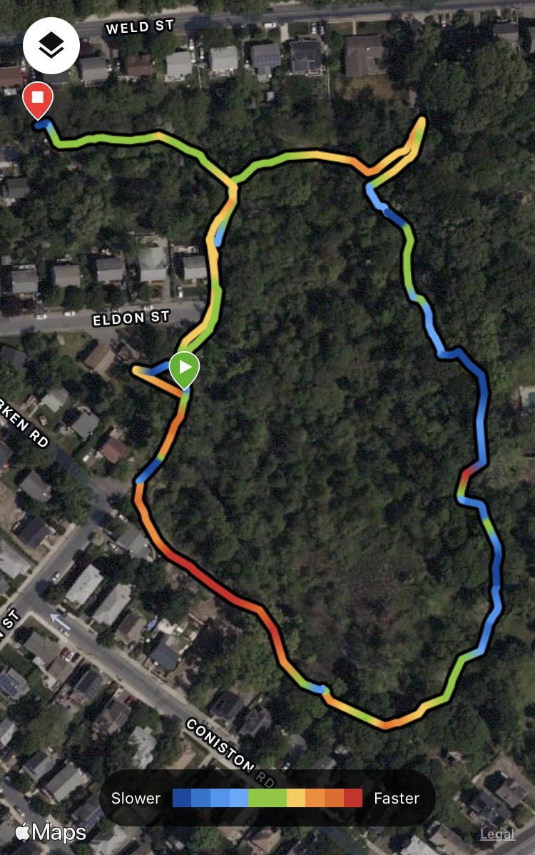
Distance: 4.55  miles

Elevation: 1155 feet
Time: 1 hour, 58  minutes

Hiking Challenges: Blue Hills Winter Trace, Blue Hill Grid, Great Blue Summits, Sunset Six


The Hike

Happy Valentine’s Day! It was (another) beautiful, spring-like day with temperatures in the 50s, and after my recent skiing weekend, I wanted to get in a “fitness hike.” My go-to fitness hike is always the Skyline Trail Loop (N & S) either from Park HQ, or from the Trailside Museum by adding in the red-dot trail(s). I decided to go big for this hike, and made my way to the north Trailside Museum parking lot (I like the south one better, but it gets crowded during ski season). I retraced my steps from my sunset hike last week around the back side of the Trailside Museum and eventually linking up with the Eliot Path to climb all the way up to the Eliot Tower. I’ve said it before, but I love this trail. It’s reminiscent of the rocky, slabby trails in the whites, and gets the heart pumping without taking any lives. There were beautiful pre-golden hour colors shining on the trees, and I decided to not climb the tower this day because there were a few people already up there.


I also love this loop because you don’t need a map or a phone to follow - just stay on the Skyline Trail! I made my way steeply down the North branch of the Skyline Trail, first down Great Blue Hill, through Wildcat Notch, and then up Wolcott Hill. There was a new bridge over the usually muddy section in the notch which was a welcomed surprise. The climb up Wolcott always takes me by surprise - my legs were already tired!


The trail through Wolcott is featureless yet beautiful. It’s been really interesting watching the forest regrow after the fires of last spring - I find it amazing how quickly it can repair itself. There is still obvious sign of damage, but it’s far less obvious than it was last time I was up this way.


Meandering over a bonus knob of Wolcott Hill, the Skyline Trail then dips out at what I call “times square” - a large intersection with a trail map at 1141, before climbing up Hemenway Hill with a few scrambles. There’s a great view of Great Blue Hill just after the high point of Hemenway Hill. Continuing on, the trail slightly descends and then climbs steeply twice to the high point of Hancock Hill, which is full of views. The best view of Great Blue Hill, in my opinion, is soon after the last steep climb, and then there’s amazing views of Chickatawbut, Buck, and the surrounding hills further down.


Descending Hancock Hill is always a little dicey - equal parts steep, slabby, and either wet and/or dusty (the views help!). Once at Park Headquarters, I followed the herd path sidewalk along Hillside Street, passing the DCR stables, before reaching the next junction, where the Skyline Trail South steeply climbs up Houghton Hill. This section of trail is in my book for “always knocks my on my ass for no good reason” - but I made it up in one piece! I started flirting with making it to the top for sunset, but I knew that I didn’t want to sprint up the trail like I essentially did last week. I would check the time and assess at 1083.


Leaving Houghton Hill, the trail meanders up and down, never too aggressively. It crosses a small stream just after 1143, some wetlands after the junction with Five Corners Path, and then finally the beginnings of the Blue Hill River. When I finally made it to 1083, the sunset was about 10 minutes away, and I was feeling the burn at this point. I allowed myself to let go of the sunset, and slowly worked my way up. After reading some of the old guidebooks, either the junction at 1083, or just at the big scramble is called “Shadow Cliff/Shadow Point” - still trying to figure out which one! Either way, I made it up in one piece, and continued my slog up the final stretch, delighted to see the intersection marker at 1066!


I turned left to continue on Skyline Trail, then turned right to hit the summit of Great Blue Hill. Just as I turned the corner around the observatory, I was surprised with the tail end of the sunset! I was so happy and it felt so good to be illuminated by that famous orange glow. I touched the plaque at the summit and enjoyed the sun’s final moments for the day - what a fantastic way to end my day!


With that final boost of endorphins, I followed the trail down to the Ski Area from the summit, crossing the Eliot Circle, to get a few final photos of the ski area before finishing my hike. I took the Eliot Circle back to 1055, and then quickly made my way down the Eliot Path to the south Trailside Museum parking lot (light was getting low so this was easier), and then I followed the sidewalk in front of the museum back to my car. A great day!


Step-By-Step

  • Start hike at north Trailside Museum parking lot.

  • Hike trails around trailside museum to meet up with red-dot Eliot Path.

  • Follow Eliot Path to Eliot Tower.

  • From Eliot Tower, take Skyline Trail North all the way to Hillside Street.

  • Turn right onto Hillside Street.

  • Turn right onto Skyline Trail South.

  • Follow Skyline Trail South to 1066.

  • At 1066, turn left to continue on Skyline Trail.

  • At next junction, turn right onto trail to summit of Great Blue Hill.

  • Gawk at the surprise sunset, then take trail from summit down to top of the ski area.

  • Retrace steps from top of ski area to Eliot Circle, follow Eliot Circle clockwise.

  • At 1055, follow Eliot Path down to Trailside Museum south parking lot.

  • Walk in front of Trailside Museum to get back to the car.


Monday, February 13, 2023

Hancock & Hemenway Hills (Blue Hills Reservation)

Hancock & Hemenway Hills (Blue Hills Reservation)

Hike Type: Spaghetti Loop

Distance: 4.18  miles

Elevation: 761 feet
Time: 1 hour, 50 minutes

Hiking Challenges: Blue Hills Winter Trace, Blue Hill Grid


The Hike

This hike is brought to you by some vague exploring. The plan was to tackle some of the trails around Hancock & Hemenway Hills - I parked at my favorite parking spot at Park HQ across from the state police barracks, and started my climb up the Skyline Trail to Hancock Hill. Instead of climbing all the way to the top, I turned left at 1172 onto the Hancock Hill Path, which is a bit of a vague intersection, but once you see it it makes sense. The Hancock Hill Path starts off pretty steep but quickly mellows out, and just as my heart rate was going down a red squirrel (my arch nemesis) darted across the trail, scaring the life out of me! I made a sharp right at 1160 onto the Breakneck Ledge Path which posed the question - what exactly is Breakneck Ledge? The trail follows the floor of a long ridge, maybe that’s it? Not sure! It’s a beautiful trail, nonetheless.


At 1178 I turned left onto the Hemenway Hill Path, which felt like road less traveled for sure. Near the top, there was an unmarked spur that led to a ledge with no views. Maybe there were some decades ago? I followed to 1154, then turned left onto Jeffries Trail, which was covered in soft pine needles, and then to Skyline so I can get to the summit of Hemenway Hill and to see the view toward Big Blue. I retraced my steps back to 1154, and then continued hiking the Jeffries Trail, which was very quiet and made me feel very peaceful. There were a couple spurs to either an old trail or an old view maybe? They seemed to lead nowhere. Toward the end of the Jeffires Trail the forest is very young with very obstructed views of Boston, and the trail eventually ends with a caged stream and well? Very curious on the history and purpose of this. 


Next I hiked the Base Path, which was relatively uneventful, and then the Circle Path, which followed a col between what might be Hancock Hill and Breakneck Ridge? There was a mysterious blue beach chair perched along the trail, and across from the chair was a footbed to what might possibly be breakneck ledge - I followed it and found a few nice views, but nothing spectacular. It was for sure strange to see the chair!


I meandered my way to the circle part of the circle path, and then hiked on Skyline to the summit of Hancock Hill - this is such a beautiful area with wayyyy too many unmarked trails. I found what I believe to be the high point, and then did my best to follow the Hancock Trail to my favorite view in the reservation. There were a few yellow blazes splattered about which helped me down the steep section just before 1201. I noticed how orange the scenery was getting, so I had another round of power hiking to maybe catch a sunset - oh boy!


I made it back to the Skyline Trail and quickly hiked back up Hancock, but the sun was behind some clouds and dipping behind Great Blue Hill - it was beautiful! But according to my rules, did not count toward the Sunset 6 challenge. Lots of airplanes were flying by as I worked my way down the Skyline Trail back to my car, overjoyed with how nice the day turned out to be. 


Step-By-Step

  • Park across from State Police Barracks on Hillside St.

  • Start hike by crossing Hillside St. and climbing halfway up Hancock Hill via Skyline Trail.

  • At 1172 (hard to see), turn left onto Hancock Hill Path.

  • At 1160, turn right onto Breakneck Ledge Path.

  • At 1178, hike to 1180 and retrace steps to Hemenway Hill Path.

  • At 1154, turn right onto JeffriesTrail.

  • At 1150, turn left onto Skyline Trail to Hemenway Hill Summit.

  • Retrace steps to 1154, continue down hill on Jeffries Trail.

  • At 1182, turn left to hike Base Path to 1183, retrace steps, and continue on.

  • At 1185, continue straight onto Circle Path.

  • Hike Circle Path all the way to its circle, then follow Skyline Trail to summit of Hancock Hill.

  • Follow Hancock Trail to 1201.

  • At 1201, turn right onto Hancock Hill Path.

  • At 1172, try desperately to see the sun set through the clouds behind Big Blue, accept defeat, and retrace steps back to car down the Skyline Trail.


Wednesday, February 8, 2023

Great Blue Hill Double Loop (Blue Hills Reservation)

Great Blue Hill Double Loop (Blue Hills Reservation)

Hike Type: Double Loop

Distance: 3.64  miles

Elevation: 850 feet
Time: 1 hour, 35 minutes

Hiking Challenges: 52 Hike Challenge; Blue Hills Winter Trace, Blue Hill Grid, Great Blue Summits, Sunset 6


The Hike

The hike that ended up being a full cardio workout - I drove down to the Trailside Museum north parking lot right after school on a beautiful spring-like day, wearing shorts! My first goal was to hike the trail that goes behind the Trailside Museum, which has a confusing entrance but clears up after 10-15 feet. I then turned onto the Eliot Path (red-dot) for a classic climb up to Great Blue Hill (one of my favorite trails), and immediately noticed how little snow there was on the ski hill. This warm winter has been delightful on the skin but very concerning to the brian. There were just a few patches of leftover ice on the way up, and the warm weather truly made it smell like a forested springtime. 


At the road, I hiked the spur to the ski slopes, which has a great view and I was able to watch some skiers belt out “I Want it That Way” by the Backstreet Boys - excellent taste in music! I wiggled my way back to the road and continued my climb on the Eliot Path, which then brought me to the Eliot Circle and Eliot Tower. I had 1,000 ideas in my head about what trails to hike, and I eventually decided I could work my way down the Brookwood Trail and back up again for the sunset (I didn’t realize how ambitious this would be…). 


I went down the Skyline North, then turned right onto Wildcat Notch, and just after 1083 took the small footpath on the right, joining the Brookwood Trail. The trail is steep and leafy, which made for slightly slippery conditions. The trail crosses the Accord Path at 1062, and fizzles out before it reaches the road. I backtracked to 1062, and then followed Accord Path to 1081, and then 1093. Now back on the Wildcat Notch Path, I worked my way back up to the South Skyline Trail.


I realized I was getting dangerously close to the sunset time, but I was REALLY wanting to see it, so I aggressively picked up the pace. Heading up the Skyline South was ROUGH and I swore a lot. The trees were either lit up with a deep orange or already in the shade. I had a chance of making it! My heart was fighting for its lift and I kept on my power walk, realizing the last time I pushed this hard with cardio was probably when I was doing drum corps. 


I could have cried when I made it to 1066 - the hard part was over! I kept hauling toward 1030, seeing some sun through the trees still. I turned at 1030, and made it to the sunset! I truly felt like I could have cried (again). It was so beautiful and peaceful, with only a few others enjoying the last moments of the day. My heart rate slowly went back down as I basked in the calmness of the sunset. Once the sun dipped below the horizon (and after I took 1,000 photos), I made my way to the summit and then back down the Eliot Path to the car. I was WIPED but so happy I was able to end on such a high note. In my notes I wrote “endorphins are high, stench is high.”


Step-By-Step

  • Start hike at north Trailside Museum parking lot.

  • Hike trails around trailside museum to meet up with red-dot Eliot Path.

  • Climb Eliot Path to auto road, then hike spur trail to ski area viewpoint.

  • Retrace steps to auto road, continue along Eliot Path to Eliot Tower.

  • From Eliot Tower, take Skyline North down.

  • At 1092, turn right onto Raccoon Hollow Path.

  • Just after 1083, follow Brookwood Trail to road.

  • Retrace to 1062, turn right onto Accord Path.

  • At 1081, turn left onto Half Way Path.

  • At 1093, turn left onto Wildcat Notch Path.

  • At junction with Skyline Trail, follow Skyline Trail to 1066.

  • At 1066, follow Skyline Trail to sunset view just after 1030.

  • Backtrack to 1030, follow gravel path to summit of Great Blue Hill.

  • Follow trail NW to Eliot Circle.

  • At 1055, retrace steps back to car.


Tuesday, February 7, 2023

Burma Road to Field Path (Blue Hills Reservation)

Burma Road to Field Path (Blue Hills Reservation)

Hike Type: Loop

Distance: 5.00  miles

Elevation: 125 feet
Time: 1 hour, 49 minutes

Hiking Challenges: 52 Hike Challenge; Blue Hills Winter Trace


The Hike

With the sun finally setting past 5:00pm, I’m allowed to go back to the Blue Hills after work again! I have a soft rule that I need to spend more time hiking than I do in the car, so for how I’ll be in the Burma/Little Blue/Great Blue area. I made it down to the Burma Road parking area around 3:30, wedged my way in between two cars, and started my journey first by doing the small trails right around the parking area (and laughing at the sign that says to NOT eat any fish caught in the Neponset River), and then finally making my way down Burma Road. 


I was ushered in by the regal honks of at least 1,000 geese flying in every which direction overhead. The bridge over a small creek is in worse shape than last year, but thankfully it held me firmly (much appreciated). The temperatures were in the mid-30s, so the ground was slightly muddy with frozen patches in the surrounding wetlands. Near the junction with the Fowl Meadow Path I was charged at by a “friendly” dog and apologized at - why can’t people just leash their dogs? Is it truly that much of a hassle?


The Fowl Meadow Path is a really beautiful area with frozen swamps on the left and thick woodlands on the right. There area a bunch of old sewers labeled “MWRA Sewer” (https://www.mwra.com/index.html) which is interesting - they’re all elevated about 3 feet off the ground. I bet this area is beautiful in peak foliage, even with the comical amount of green prickers. There were also some old “artifacts” laying around the small spur trail, including a skateboard nailed to a tree. 


Finally at the Indian Path along the Neponset River, I saw that the ice-line was a foot above the water line, probably a good sign? Soon after I made it to the first water crossing and it was not a good sign. There were dozens of thin branches laid across the crossing with maybe thicker logs underneath? A topsheet of ice did not settle my nerves, and after starting it and randomly steeping for a few minutes, I put my tail in between my legs and turned around. I did not want to get wet today. I was really bummed, but such is life!


My redemption plan was to tackle the trails on the east side of Burma Road. I begrudgingly backtracked, passed another hiker heading north along the Neponset River on what appears to be a trail that’s not on the map, and at 6005, continued along the Fowl Meadow Path, over a wide bridge, and then to the Swamp Trail. The Swamp Trail has been flooded both times I’ve hiked it, but today it was frozen! Thank goodness. The trail itself is narrow, scenic, interesting, and painful (lots of prickers), with evidence of an old old boardwalk. There are also a lot of old rusted items littering the woods - are they a result of flooding? Abandoned homes? Someone going really out of their way to not pay dump fees?


Now turning right onto the Green Hill Path (who is Green Hill??), I wasn’t sure if the infamous Field Path would be on the docket for the day, but I’d hike that way just to see where the winds took me. The woods here were spooky - the sun was setting and I spooked a family of deer, which then spooked me. At one point my bag made a swishing sound and I thought it was the sound of a child screaming , but apparently I was not being possessed. I finally made my way to the unclear junction with the Field Path, heard at least one of the deer splash their way into water, and decided I was already planning to do one rite-of-passage trail today, so let’s go for it. I was delighted to see pink marking tape blazing the trail, and it was significantly less overgrown than last time. Whoever the patron saint of the Field Path is, thank you. There were still a couple of blowdowns, one was particularly tricky, but I made it out with only one visible scrape!


I took the Orchard Trail back, which was calm and featureless. The sun was about to set behind the clouds, so my goal was to pick up the pace and get back to Burma Road before it was too dark. I continued along the Green Hill Path once the Orchard Trail ended, hiked the spur to the east, and then followed the path as it continued outside of DCR park boundaries into “conserved private land” - or something like that. The terrain in this area was really interesting - almost like dirt canyons. I wonder if this is because of erosion, development, or just something else (aliens)? The trail continuation brought be back to the Swamp Path, and then to Burma Road. When I was about 0.5 mi. from the parking lot I passed someone with their dog walking in toward 6005, which was interesting (driving home from the next day’s hike I saw his same car in the dark, I guess he enjoys the solitude). Soon enough I was back at my car with just a smidge of daylight left - initially bummed because I wasn’t able to safely get the Indian Path, but happy I was still able to accomplish some trails.


Step-By-Step

  • Park at Burma Road parking area.

  • Start hike at “Fowl Meadow” granite marker, hiking along Burma Road.

  • At 6005, turn right onto Fowl Meadow Path.

  • At unmapped 6009, turn left to hike unnamed short path. Unclear when to turn around, so I turned around at a big tree. Retrace steps.

  • Continue along Fowl Meadow Path until terminus at Neponset River.

  • Turn left onto Indian Path along Neponset River, have a crisis at first crossing, and retrace steps all the way back to 6005.

  • Continue straight through 6005 onto Swamp Trail toward 6105.

  • At 6105, turn right onto Green Hill Path.

  • At 6103, turn right onto Field Path.  

  • Survive the field path onto junction 6102.

  • At 6102, continue onto Orchard Trail.

  • At 6104, continue onto Green Hill Path.

  • At 6106, turn right to hike spur trail and retrace steps.

  • Continue along Green Hill Path, leaving the Blue Hills Reservation, and then rejoining the Blue Hills Reservation on the Fowl Meadow Path.

  • Follow Fowl Meadow Path to 6005, and then follow Burma Road to car.


Monday, February 6, 2023

Roslindale Wetlands (Boston Urban Wilds)

Roslindale Wetlands (Boston Urban Wilds)

Hike Type: Loop

Distance: 0.58  miles 

Elevation: 10 feet
Time: 24 minutes

Hiking Challenges: 52 Hike Challenge


The Hike

This was a spur-of-the-moment “hike” (I decided it was a hike because I was in the woods on a trail) in the middle of my hot girl walk. I entered through the entrance at the corner of Selwyn and Robken Streets and took the loop clockwise. The eastern half of the loop was beautiful and manicured, with new boardwalks and bridges and a crushed gravel path. The wetlands themselves were still frozen but with about 0.5 inches of water on top of them, which was lovely to look at. The western half was a bit of a muddy mess - I slipped and sloshed all about, and got uncomfortably close to many backyards. There was one pull-off viewpoint, and soon enough I was back where I started! I went down one more entrance to Hazelmere Street to exit the wetlands. I would hike this area again in a drier time of the year, for sure!


“Roslindale Wetlands” from Boston.gov

        The Eldon Street I urban wild is located to the east of the Arnold Arboretum and is roughly bordered by Hazelmere Road, Weld Street, Robken Road, Selwyn Street, and the Eldon Street II Urban Wild. The area is generally surrounded by the backyards of abutters; however, several obscure entrance points do exist into the urban wild. In an area of low topography, the Eldon Street urban wild serves primarily as a catch basin for the area's stormwater and is thus dominated by a forested wetland habitat. The area has been overrun by non-native, invasive species, especially multi-flora rose and buckthorn. At one time, a boardwalk permitted entrance into the wetter sections of the wild from Eldon Street. However, the overwhelming presence of multi-flora rose now makes this entry impossible.

        The Eldon Street II Urban Wild is located to the east and contiguous with Eldon Street I. The site is bordered by Walter Street, Selwyn Street, and Coniston Road. Like Eldon Street I, this area is surrounded by the backyards of abutters. However, two vacant lots do provide access into the urban wild. Although containing some higher topography than Eldon Street I, this urban wild still serves primarily as a catch basin for the area's stormwater, and is dominated by a forested wetland habitat.


Sunday, February 5, 2023

Overlook to Little & Great Dome Loop (Blue Hills Reservation)

Overlook to Little & Great Domes Loop (Blue Hills Reservation)

Hike Type: Spaghetti Figure-8 Loop

Distance: 6.32  miles

Elevation: 459 feet
Time: 2 hours, 16 minutes

Hiking Challenges: 52 Hike Challenge; Blue Hills Winter Trace, Blue Hills Grid


The Hike

The past few days have been a comical deep freeze (when I left the bar on Friday night, the wind chill was -32!), so I waited into more survivable temperatures to venture out. Since I knew everything would be well frozen, I decided to tackle the section near Little Dome that has been routinely swamped every time I’ve hiked it. I was admittedly a little hungover on this Sunday morning, so I slowly made my way out of my house (after having to use the bathroom four different times… bar pizza has never sit well with me… and eventually started my hike around 10am with temperatures shockingly in the upper 30s. I parked at the Chickatawbut Overlook and got my day started!


I started on the Cedar Rock Path and immediately rejoiced in finally being able to be outside again. There were a few winding cross-paths, one labeled high up on a tree as NOT being the trail, but I was able to use AllTrails to follow the correct path. At the terminus, the first thing I did was hike the spur to Nahanton Ave., something I missed during my 125-Mile Club Challenge. This spur crosses the old continuation of the Sassaman Trail, which connects to the CCC Camp… this might be a trail I explore in the future. I planned to hike on the Pipe Line down to the junction of Chickatawbut Road and MA-28, but there was a big group headed that way and I was feeling extra antisocial this morning, so I’ll save that for another day!


I was beyond happy that the Pipe Line was frozen over, so what would usually have been wet, sloppy mud, was now crunchy ground. The trees were harshly blowing in the wind, but temperatures were quickly rising. The only worrying thing about the weather was hearing branches snapping off trees in the wind, but thankfully I was not mutilated. I made it to the unnecessarily steep section and wondered how a Pipe Line traverse would go… the pipeline does go under I-93 which would create a unique challenge…


I finally made it 4066 and was delighted that my plan had worked - the ever-flooded section of trail was frozen! I quickly made it through and to the gas plant, which was very stinky and ominous (the warning sign for venomous snakes for sure added to the ambiance), and then I made my way over to Little Dome. There is no official trial to the top, and the “summit” mound was clearly visible, so I bushwhacked my way up and was pleasantly surprised with a nice view! Obstructed views of Great Blue Hill and Chickatawbut Hill (I think), but very quiet. I was joyed to find a herd path/abandoned trail heading from the summit of Little Dome down to the Sawcut Notch Path, which was the next leg of my journey.


The Sawcut Notch Path skirts the border of what I believe is the old Quincy landfill and now the Granite Links golf course with a few “fragile ecosystem” signs along a busted chain-link fence. A part of me (most of me) wishes that the landfill was turned into more parkland rather than a golf course, but I digress… Just before the height of land in this area I saw a small footpath heading up Great Dome - is this the old trail? I followed the path and it was really beautiful hiking on soft ground. There is a false summit, a small col, and then (what I believe to be) the main summit area. Right before the col the path fades away and it becomes a “choose your own adventure” moment. I stayed right, made my way through some deep leaves and a small scramble, and came out to a great view of Great Blue and Chickatawbut Hills! I was surprised to find such a nice view on an abandoned trail, but so happy to be there. 


I could not tell where the Great Dome Trail continued from the top, so I backtracked on down back to the Sawcut Notch Path. The hike got less exciting from here, which was a welcomed break considering I was sweating through my fleece (again). I made a figure-8 loop with Short Path, Crags Foot Path, Old Furnace Brook Path, and then back to Sawcut Notch Path, where there was a lovely pond near the height-of land. I was delighted to see the wet sections of Old Furnace Brook were still frozen over!


Finally on my return trip, I made my way to 4091 to 4090 hiking a couple triangles in between, and then I turned onto the existing Great Dome Foot Path at 4090. The trail dips down to cross the Pine Tree Brook, which I accidentally dipped my toe into, and then worked my way steeply back up. I intended to follow the Great Dome Foot Path all the way to Chickatawbut Road, but got spooked by a giant group of hikers. Instead, I joined the Pine Tree Brook Path, followed to the Ridge Path, and then at 4072 rejoined the Great Dome Foot Path to Chickatawbut Road - which featured some mysterious yellow blazes! I hugged the shoulder of Chickatawbut Road to finish my hike back to the car, and told myself that I will be throwing out the Cotopaxi socks I’ve been using for literal years in hommage to my newly forming blisters.  


Step-By-Step

  • Park at Chickatawbut Overlook and hike on Cedar Rock Path to its terminus.

  • At terminus, hike spur out-and-back to Nahanton Ave. 

  • Back at terminus, hike on Headquarters Path/Pipe Line all the way to 4066.

  • At 4066, continue straight to gas plant.

  • At gas plant, walk through, and continue on trail toward Little Dome. 

    • Here, I bushwhacked to the summit of Little Dome.

  • From summit of Little Dome, follow herd path/abandoned trail to Sawcut Notch Path and turn left.

  • Follow Sawcut Notch Path - just below the height-of-land there is an unmarked intersection for the former Great Dome Trail. Follow trail (as best as you can) to summit of Great Dome, retrace steps.

  • Continue on Sawcut Notch Path.

  • At 4133, turn right onto Short Path.

  • At 4124, turn left onto Crags Foot Path (green dot).

  • At 4145, turn left onto Old Furnace Brook Path.

  • At 4180, turn left onto Sawcut Notch Path.

  • At 4083, turn right.

  • At 4091, turn right onto Indian Camp Path (green dot).

  • At 4086, hike to 4082, then to 4085, and then turn right onto 4090 (Great Dome Foot Path)

  • At 4073, turn left onto Pine Tree Brook Path.

  • Follow Pine Tree Brook Path to Ridge Path.

  • Follow Ridge Path to 4072.

  • At 4072, turn left back onto Great Dome Foot Path.

  • Hike Triangle between 4053 and 4052.

  • Follow Chickatawbut Road back to car.