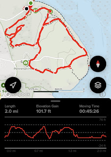
Hike #1: Fort Hill & Red Maple Swamp Trails
Distance: 2 miles
Elevation: 101 feet
Time: 45 minutes
Elevation: 101 feet
Time: 45 minutes
The day started out with a bang! We used the lovely vault toilets right at the parking area (which we're not sure if we were supposed to be at or not...) and followed the trail closest to the water first, as the sun was beginning to rise. We made sure to hike the trails on the NPS map that were marked, although there were more paths in the area. Right as we got a view of the water, the sun began to poke above the horizon - beautiful! We climbed the gentle hill and eventually dipped into the woods for the Red Maple Swamp Trail, which was a really nice boardwalk walk back to the car.
Hike #2: Buttonbush Trail
Hike Type: Loop
Distance: 0.4 miles
Elevation: 52 feet
Time: 10 minutes
Distance: 0.4 miles
Elevation: 52 feet
Time: 10 minutes
The next stop was the Buttonbush Trail at the Salt Pond Visitor Center. This trail is a trail specifically designed for folks with visual impairments, which made this easy trail very interesting. This area connects to the longer Nauset Marsh Trail, which Gen and I had hiked last year. We explored the visitor center a bit afterward, and then drove a little further in for our next hike.
Hike #3: Doane Loop
Hike Type: Loop
Distance: 0.6 miles
Elevation: 32 feet
Time: 14 minutes
Distance: 0.6 miles
Elevation: 32 feet
Time: 14 minutes
This stop was more of a formality - we had previously hiked most of this area but for our self-imposed patch challenge we needed to clean up the rest of it. Very gentle, very paved, very big rock. Not much else to it. I guess technically some history, but we were too lazy to read into it. Next!
Hike Type: Lollipop Loop
Distance: 1.5 miles
Elevation: 128 feet
Time: 33 minutes
Distance: 1.5 miles
Elevation: 128 feet
Time: 33 minutes
This was one of my favorite trails. We parked at the trailhead and first went over the ocean overlook, which had a decent drop off to the shoreline. Into the woods we followed a great boardwalk system through a beautiful cedar swamp. The return trail was on an old woods road with a gentle incline.
Hike Type: Lollipop Loop-ish
Distance: 3.2 miles
Elevation: 525 feet
Time: 1 hour, 21 minutes
Distance: 3.2 miles
Elevation: 525 feet
Time: 1 hour, 21 minutes
Now this was the pinnacle of "Cape Cod Hiking" of the day. The wewather broke into the low 50s, which meant it was shorts time! The trail starts by climbing Berberry Hills West and Easy summits, which offer great views of the area. We then took the side trail to the old Bog House that was a little spooky, and then began our hike on the great dune system. Where we hit 2 miles was a long trail that we couldn't find much infomation on - apparently there used to be an overlook a ways down, but I read it was well overgrown now. I also found a tick on me which sent me through a mini crisis - but we prevailed. The trip nearest the ocean is high up on the dunes and just spectacular. We concluded our hike by retracing out steps back to the car - just amazing!
Hike Type: Figure 8 Loop
Distance: 1.3 miles
Elevation: 197 feet
Time: 33 minutes
Distance: 1.3 miles
Elevation: 197 feet
Time: 33 minutes
We were officially in the upper cape! This was a combination of two loop trails that join at the trailhead. First was Small's Swamp, which was a nice easy loop around a swamp, sometimes on trail sometimes on boardwalks. There was one flooded section of boardwalk, but not enough to get our feet wet. There were some views towards the end.
Pilgrim Spring Trail was a bit longer and bit less used, but had some great views of the nearby wetlands and the ocean in the background. Even being on someplace as busy as Cape Cod, we really felt like we were the only ones around. It definitely helped that it was winter... Anyway, one more stop to go!
Hike Type: Figure 8 Loop
Distance: 1.1 miles
Elevation: 164 feet
Time: 1 hour, 19 minutes
Distance: 1.1 miles
Elevation: 164 feet
Time: 1 hour, 19 minutes
The final stop for the day was all the way up in Provincetown - the Beech Forest Trail. We easily saw the most people of the day here. It first looped around Blackwater Pond, which was partially frozen over, and then had a secondary loop through some sandy woods. There was a side trail up to a tune with some cool other-worldly views. Once we finished we hit up Cumberland Farms, ate at Race Point Beach, and began our long drive home (we later realized we hit up every Cumbies on US-6 on the cape this day). Great day!
Originally written September 30th, 2022.


No comments:
Post a Comment