St. Moritz Pond to Fox Hill Loop (Blue Hills Reservation)
Hike Type: Spaghetti Loop
Distance: 5.64 miles
Elevation: 577 feet
Time: 2 hours, 28 minutes
Hiking Challenges: Blue Hills Winter Trace
The HikeIt finally stopped raining and snowing after what seemed like 1000 day. Today brought me to the St. Moritz/Quarries area of the reservation. I parked at the Shea Rink and started on the Skyline Trail. The woods were snow-covered and the ground was muddy. I followed the green dot blazes counter clockwise for the first part of this hike. The weather was just below freezing and the views were lovely. The green dot blazes then brought me to the infamous Pipe Line, which was just as dreadfully wet as I remembered!
I turned onto Murphy Path which led me to the Skyline Trail. It’s been about a year since I’d last been on this section, and it was great to be back! I crossed Wampatuck Road and followed the blue blazes. There was one tree labeled with its species and age which was really cool to see - I wonder if there are any more of these in the reservation? The dusting of snow was absolutely beautiful on the trails and trees.
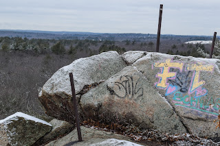
The trail goes around an old quarry that was beautiful in the snow (curious the history of this area), and then curves around the pit up the side of Rattlesnake Hill. I meant to find the abandoned side path to the summit of Rattlesnake Hill, but didn’t realize I was there until it was too late! The trail climbs a little more up to the Crags, which I realized I’ve never taken the spur to the view. It was breathtaking! The nearby hills covered in snow were beautiful. There were also remnants of an old fence at the view - which of course I’m now curious about.
The trail is sketchy getting down from the Crags, but I made it unscathed! The trail at the bottom (4155) was fully inundated with water, and I tried to rock hop, but hit a loose rock and landed right in the stream. Thankfully my waterproof boots saved the day! The trail gently climbs up Wampatuck Hill and provides some more views. I saw on a map there is (or used to be) a USGS marker at the summit, but I couldn’t find it (the snow didn’t help) - I’m sure there would at least be a drill hole somewhere.

Coming down Wampatuck was the moment where I remembered that I’m supposed to be working on sweat regulation - I was not doing a good job. My whole body was steaming! The steam turned into condensation, which then froze on my shoulders. Thankfully, I was feeling warm and fine. I hiked the loops of trails around the Pipe Line and then made my way up the gentle trail to Fox Hill, and turned at the summit to hike down the north side.
This trail was similar to that around Hawk or Kitchamakin Hills - unclear and blazed with mysterious yellow dots (which I was delighted to see). The trail was easy to follow with the dots, and it opened up to a nice view north (with a bit of Boston behind the trees). The trail was harder to follow after the view, especially in the final ~25 feet, but I made it!
The rest of my hike was long but uneventful. The green dots led me through very wet and wide trails, with a few afternoon folks out and about. I decided, while on the theme of wet, to take the Old Furnace Brook Path, which has been flooded every time I’ve hiked it (it was today too!). My final stretch of new trail was on the Sawcut Notch Path, which led me to Wampatuck Road, and the Skyline Trail back to the car. The ponds were beautiful, but the trail between them was a muddy disaster. Either way, it was a lovely morning and my lungs were feeling good!
*Edit to add: the old quarry the Skyline Trail skirts around is called “Sullivan Quarry.” The fence posts atop the Crags used to have a horizontal bar connecting them as a barrier to ideally prevent falling. There are likely no USGS discs in the Blue Hills (sad).
Step-By-Step
Start hike on Skyline Trail from Shea Rink.
At first junction, turn left and follow green dot blazes.
At 4205, turn left onto Pipe Line and continue following green dot blazes.
At 4202, turn right onto Murphy Path.
At 4220, turn left onto Skyline Trail.
Follow Skyline Trail to 4134.
At 4134, hike area trails around Pipe Line.
Where Pipe Line reaches Chickatawbut Road, turn right onto Fox Hill Path.
At summit of Fox Hill, turn right to follow trail down to 4120.
At 4120, turn left and follow green dot blazes.
At 4145, turn left onto Old Furnace Brook Path.
Rejoin Skyline Trail, cross Wampatuck Road, and follow Skyline Trail back to car.


No comments:
Post a Comment