Gunstock Mountain via Ledges-Iron Mine and Marges Loop (Belknap Range)
Hike Type: Lollipop Loop
Distance: 3.64 miles
Elevation: 1,545 feet
Time: 2 hours, 11 minutes (1 hour, 54 minutes moving)
Hiking Challenges: Belknap Range Redliner; Belknap Range Grid
Hiking Challenges: Belknap Range Redliner; Belknap Range Grid
The Hike
Last ski weekend of the season :-(. Also, it had been raining for what has felt like 40 days and 40 nights. I had a SUPER slow morning due to the rain and some decision paralasys. I was originally going to join Emma's family for dinner in VT, but I wanted to hike too, but it was raining. Her day got hectic and she told me it's easier if I just go to her house, which was the update I needed because then I checked the weather for Gilford and saw rain was ending around 1:00pm, so I decided I'd hike in the Belknaps and then find Emma later! I felt insane wearing my glitter cros and "even Jesus said Jesus when he saw me ski" hoodie in Hooksett, which was super crowded, but I got some food and continued onto the trailhead, landing around 1:20pm. It was still drizzling, so I read a chapter in The Lions of Winter: Survival and Sacrifice on Mount Washington, Ty Gagne's newest book (it's so good!) as the pitter-patter faded into quiet.

I got suited up with the mountains in the clouds and very small bits of mist falling from the sky. The bugs and birds immediately came out, and thankfully only the birds stuck around. It was chilly in the upper 40s, but I decided to be bold and start cold (always the right move for me) and got hiking at 1:35pm!

"This area is open daily from dawn to dusk. No camping, campfires, overnight parking or motorized vehicles are allowed. Please keep our trails clean and pack out everything you pack in. While we welcome dogs, they must be under your control at all times and their waste removed from trails."
"Welcome to the John M. and Eileen R. Weeks Conservation Area. This 65-acre property was protected by a collaborative effort by the Town of Gilford and the Lakes Region Conservation Trust (LCRT). The Town purchased the land through its Conservation Land Fun, and LRCT purchased a conservation eastment, which adds an additional layer of protection. In the past, the Weeks Conservation Area was used as sheep pasture, a blueberry farm, and for timber harvesting. Today, the property is conserved for wildlife habitat and public recreation. Follow the Ledges-Iron Mine Trail to a ledgy vista, the remains of a historic Iron Mine, and the other trails in the Belknap Mountain Range.
I continued up the blue-blazed Ledges-Iron Mine Trail, past more tired down on the left, and up the road-graded trail. It was wide and surprisingly dry! My left achilles was a little fired up, but that soon waned. It was no longer raining out, but water was still falling on my head whenever a tree shook. The trail paralleled two parallel stone walls on the right as it gently climbed through a forest of light green leaves. I was a little thirsty, but realized my only Nalgene was in my pack, not in the side pocket where it belongs, so I decided I'd just dehydrate myself (dummy).

My sleeves went up after 10 minutes and the trail continued through a flat stretch that smelled wonderfully. It then turned a corner and became comically wet, which made complete sense. I climbed through the running water, which led to a surprise WONDERFUL view! I guess this is the namesake ledge. The cloud ceiling was low, but the early spring colors were abundant at this almost-180-degree vista. According to my PeakFinder app, I would have been able to see Monadnock, Kearsarge South, Stinson, and Moosilauke - I'll have to come back some time! The ledge did invite some exploring, but it was wet and slippery and I was NOT going to f- around and find out.

After the ledge, the trail was now blazed in blue AND yellow, and turned back into the forest before resuming a climb on a footpath, soon coming to a split where yellow-blazed Marge's Trail departs on the left and blue-blazed Ledges-Iron Mine Trail continues on the right. I had officially arrived at the cloud ceiling! I got my water finally and continued hiking in this spooky, open forest. The trees were covered in moss and lichen and were frequently blazed. The foliage was a bright, lime green, and the cloud ceiling began to rise as I hiked.

"The Gunstock Iron Mine
For a short time in 1827 this spot was the site of an iron mine. During the previous year an ore-bearing vein was discovered and entrepreneur Branch Harlow saw an opportunity to produce iron commercially. Althought the ore recovered was of excellent quality, so little of it was found that it eventually proved too costly to mine. Toward the end of the mining operation, a deadly accident occured when a charge of blasting powder exploded prematurely, killing one man and injuring two others.
Some of the ore that was recovered from the mine was of such high quality that it could be worked into useful products without being smelted. Gilford blacksmiths made nails from this "Gunstock Iron." It is reported that some of the older structres in Gilford still contain nails made from the ore taken from Gunstock Mountain.
The remains of this mining operation consist of two shallow cuts that contain a variety of minerals including magnetite which will affect a compass. In various places in the cuts, a magnet will stick to the rock. The section of trail immediately below this spot follows the original mine haul road built to transport ore down the mountain by oxen.
The first mine was smaller than the longer second one, both of which were super neat! There was another, identical sign at the top of the second mine that had been knocked down by a tree, but someone propped it up to still be enjoyed by hikers.


After the mines, the trailbed felt less-used and became very soft and STEEP. Water continued to fall off the trees onto me as I passed some kind of chipmunk-sized rodent with a small tail at a steep switchback - some kind of mouse. The climb continued steeply up until entering a ferny, bouldery area, which turned out to be the end!

I was now on the Ridge Trail heading towards Gunstock Mountain, but to make things ~interesting~ I decided to descend the Winter Shortcut and hike the remaining stretch of the Gunstock Mountain Trail that I still needed. I remembered this trail being steep, so I (worked a little too hard) took out my poles, which turned out to not really be necessary. The trail was wet, but not too slippery. There were a few slabs, but they really weren't a problem. I was at the end faster than expected!

Now I was on the Gunstock Mountain Trail, which I think would be fair to rename the Gunstock River. It was so comically loud and wet with flowing water literally everywhere! This was when I was actually glad to have my poles out! I kept hearing the words "so much wetter!" in my head to the tune of "So Much Better" from Legally Blonde the Musical - it was comical, but eventaully came to a nice ledge toward Piper and the sunny valley to the south (I was still at the edge of the cloud ceiling).


There was a walking break through what was essentially a small pond after the outlook, which was followed by a steep, slippery climb with a scrambly chute near the end, but this brought me back to the Ridge Trail and another nice viewpoint!

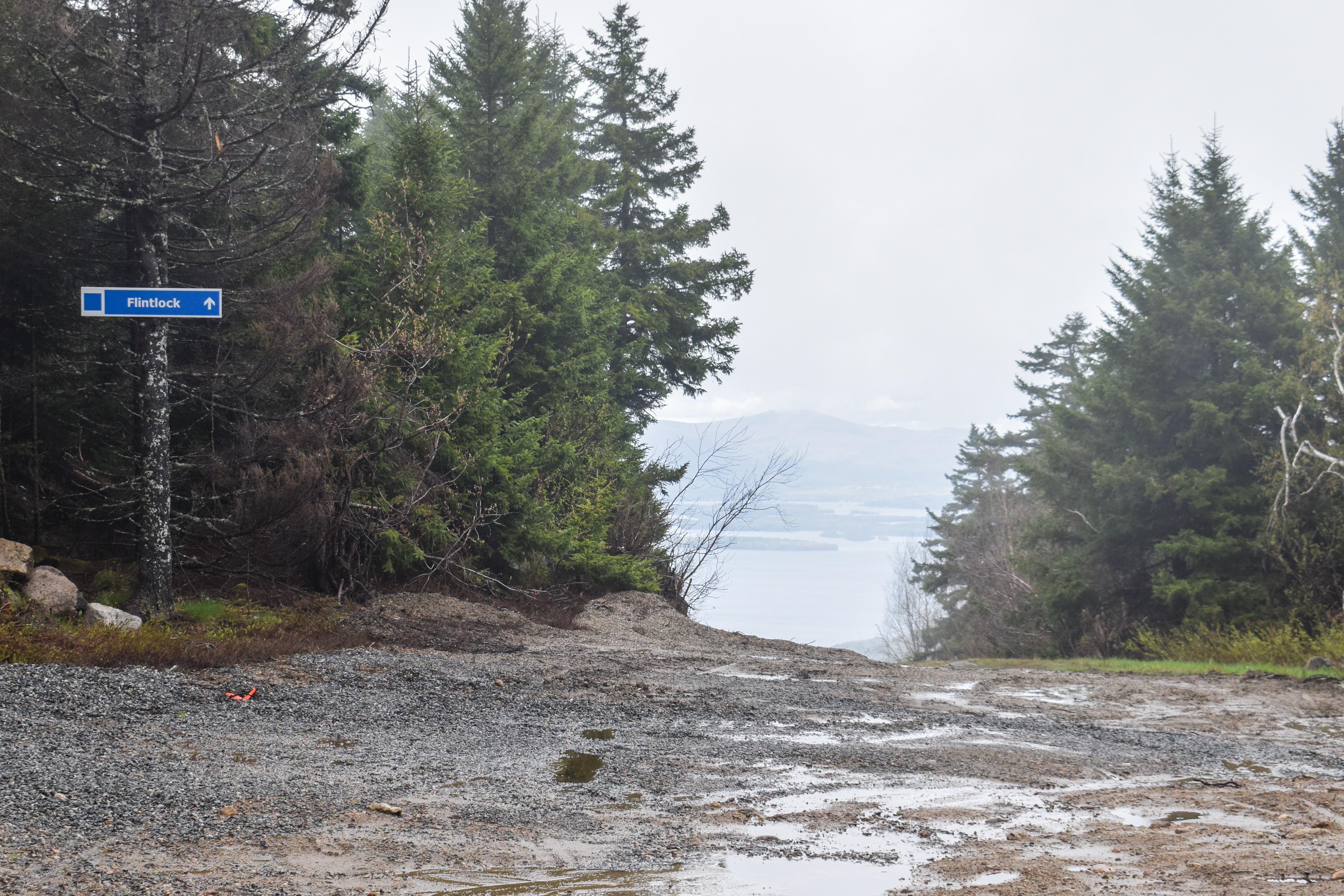
I made the executive decision to follow the Flintlock ski trail down, as it connected with Marge's Trail. It felt a bit like I wasn't supposed to be there, but worst case someone yells at me and they make me turn around. The view was EXCELLENT from this trail, which had awful, wet footing. The view kept improving as I descended out of the cloud, featuring Mt. Rowe in the foreground followed by the lake and further peaks. I passed the only bit of remaining snow, some fiddleheads, and then turned onto Marge's Trail, marked by a piece of orange flagging tape.


Marge's Trail crossed the Ridge Trail and was now blazed with yellow diamonds. I flirted with going to Rowe, but I still had a three hour drive to Emma's and I wanted pizza, so another time! Marge's Trail was a little car wash-y up top and then began to steeply descent with soft, wet, stream-like footing. I paused at a wonderful overlook to respond to a text I forgot to respond to a month ago (typical for me), and then continued on past a couple of red efts!

I passed another eft as the trail gently rollercoastered up and down and reentered conservation land, soon turning to coincide with the Ledges-Iron Mine Trail again. I enjoyed the view from the ledge again, but the cloud ceiling had only risen slightly, so not much had changed.

From here on out, I noticed I was following mountain bike tracks that I hadn't seen before... hmm... I continued down through the final wet section, which had my socks fully soaked at this point (my waterproof boots might be at the end of their lives), eventually making it onto the final straightaway, which was wonderfully dry.


Step-by-Step
- Park at Ledges-Iron Mine Trailhead.
- Start hike on blue-blazed Ledges-Iron Mine Trail.
- At ledge, yellow-blazed Marge's Trail joins.
- At split, turn right to stay on Ledges-Iron Mine Trail.
- At terminus, turn right onto white-blazed Ridge Trail.
- At next jct., turn right onto green-blazed Winter Shortcut.
- At terminus, turn left onto orange-blazed Gunstock Mtn. Trail.
- Summit Gunstock Mountain.
- From summit, follow Flintlock ski trail.
- At orange flag, turn left onto Marge's Trail.
- Cross Ridge Trail, continue onto yellow-blazed Marge's Trail.
- Before ledge, Ledges-Iron Mine Trail joins.
- At ledge, continue right on Ledges-Iron Mine Trail back to car.
No comments:
Post a Comment