Mt. Passaconaway via Wonalancet, Square Ledge, Walden Trails (White Mountain National Forest)
Hike Type: Loop
Distance: 12.98 miles
Elevation: 4,747 feet
Time: 8 hours, 35 minutes (7 hours, 10 minutes moving)
Hiking Challenges: 52 Hike Challenge 2025; 52 With-a-View
Hiking Challenges: 52 Hike Challenge 2025; 52 With-a-View
The Hike
Happy 1st day of Pride Month! I was celebrating by doing what I do best, going into the woods to be by myself! I had the invitation to join Sarah and Alec on their hike around Hale and Zealand, but I was really itching to knock off two more delisted 52's and wanted some alone time after another rough week at work. I woke up at 3:30am and really took my time, eventually leaving at 4:00am. I had a misty drive to Hooksett, which took exactly one listen of "Come From Away" to get to. I unfortunately did not accomplish any bathroom needs at Hooksett, but I did get some breakfast from the lady that overshares (I ran into her previously this past winter). She told me all about how Celsius makes you skinny and how her 17 year old, who is not yet a man and still has his "boy body" but is slowly turning into a man, drinks them and is still super skinny. I must be drinking the wrong kind of Celsius, then!
I had a sleep drive from Hooksett to Exit 24, but I slowly woke up as I drove along NH-113, dodging all kinds of carnage from the overnight wind (mostly sticks and branches, but also one very excited deer). I visited the porta-potty in Center Sandwich to... accomplish a task, and made my way over to NH-113A and eventually to Ferncroft - such a beautiful drive! It was very cloudy overhead, but only the tip of Mt. Whiteface was in the clouds, which I was thrilled about.
At the trailhead, it was a chilly 47 degrees and there were only three other cars. I did a quick walk back to Ferncroft Road to get a photo of Mt. Wonalancet, my first goal for the day, and soon put my fleece and long pants on because I was CHILLY. On the plus side, chilly temps and a breeze might mean that there won't be bugs! Fingers crossed...

[6:45am - Start of Hike on Old Mast Road]
It was 6:45am, I had my long pants and fleece on, and it was time to start my adventure! I was donning a water bladder in my pack for the first time since last fall, but my new bladder felt weak and flimsy. I was worried about it rupturing (I was fine), but the quality was pretty poor and was not too pleasant to use. I hiked along Old Mast Road on the road grade and veered left at the Gordon Path Junction.
[6:47am - Old Mast Road/Gordon Path Junction]
I passed a sign indicating Lakes Region Conservation Trust land and some blue blazes along the wide path, and delighted to experience zero bugs! Soon, I came up upon the junction with the Wonalancet Range Trail.

[6:50am - Wonalancet Range Trail]
The Wonalancet Range Trail left the road grade onto a footpath, following Spring Brook a short distance before turning left to switchback onto a bank. The trail continued through a trough and turned again into a beautiful, flat, open forest. I hiked past an old blue metal disc blaze and appreciated the frequent blazing and occasional arrows that this area offered - even the faded blazes were helpful! My fleece came off at 0.40 miles, I stepped over an easy blowdown, and began to climb again around 0.55 miles. Unfortunately, my hamstrings were still feeling sore from leg day on Tuesday (which was five days ago... ouch). My water tasted a bit like the tube, but once I got past the first few sips, it got much better.


[7:13am - Wonalancet Range Trail/Sandwich Range Wilderness]
Once at the Sandwich Range Wilderness sign, I took a quick break to change into shorts and relieve my bladder. I giggled at a chunk of the sign missing - it look someone took a bite out of it... like... a sandwich!

Here, the footbed slightly narrowed and the trail began to get a bit more rugged. I hit a couple of wet spots after the 1.00 mile mark, but I was just grateful that it took this long to hit a wet spot, as it had rained overnight. I did wear my (mostly) waterproof boots, thankfully! The frequent blazing continued, and by my understanding of the guidebook, they likely stopped blazing it once this area became a wilderness area, which would be 1984. Not sure, though.
As I gained elevation, I noticed that my ears were continuously popping. I was thinking it was mostly due to the weather and actually climbing, but I think in reality I was just getting sick (as I write this a day later, I'm not feeling too fantastic). I climbed through a lush green tunnel, slightly missing the tree views of winter, and then I traversed a few bouldery areas that were wonderfully dry.


[7:46am - Wonalancet Range Trail/Shortcut]
The "very steep pitch" led to a bit more trail with extremely obstructed views towards Mt. Paugus and then to the junction with the Shortcut trail. I was nervous about the potentially difficult ledges ahead on the Wonalancet Range Trail, but decided I'd keep moving forward, and if worse came to worse I could always turn around (thankfully, worse did not come to worse).
Continuing on the Wonalancet Range Trail, it began to get a bit breezy and chilly, especially once on the potentailly difficult ledge. The ledge was potentially difficult, as reported! Overall it wasn't too bad, and I was moving more cautiously than usual since it was still wet. There were a few tiny painted trilium flowers cheering me on, and I took a pause halfway up to get up one trickier spot. When I turned around, I realized I was in a grove of at least 20 pink lady slippers! What a treat!

I carefully got up the one trickier spot and then carefully walked up the rest of the slab, which showcased my first of many wonderful views for the day! I could see Mt. Chocorua, Mt. Paugus with it's red dirt, and the valley below - it was really beautiful, covered in a light, early spring green.


The quality of life on trail immedaitely improved after the ledges. Footing was more reasonable as the trail climbed moderately to a wide right turn, where it switched from "better" to "wonderful." There was new, bright green growth on small evergreens and a hint of sunshine as the trail essentially plateaued and continued onto the featureless summit of Mt. Wonalancet.
[8:11am - Wonalancet Range Trail/Mt. Wonalancet]
The summit was in a bouldery area with a soft, flat trail. It was 43 degrees up here and shocking dry! I even passed two owl pellets (no owl) right next to the summit. The wind was HOWLING overhead, which caused me to pause a few times.


The Wonalancet Range Trail gently descended to the col between Mt. Wonalancet and Hibbard Mountain, briefly passing through a deciduous area with bountiful hobblebush. I passed some painted trilium, very obstructed tree views to Mt. Whiteface, and soon arrived to the col, which is where the other end of the Shortcut Trail tops out.

[8:23am - Wonalancet Range Trail/Shortcut]
Now, the Wonalancet Range Trail began to climb again, but never steeply. It traversed a nice bouldery area with a MASSIVE erratic off in the woods on the left. My hands were feeling cold due to the chilly temperatures and the constantly moving air (thankfully, the trees sheletered me from the full wind). I also noticed some of the painted trilium were translucent - I wonder why?

I soon came to the VERY obvious view spur on the right near the summit (no sign). The footbed was crystal clear and even felt like it was the more-trafficked route. The view ledge had a great view back to Mt. Wonalancet and I believe Mt. Israel on the right. To the left in the foreground was the Ossipee Range, with Mt. Shaw standing proudly in the middle, and then the Belknaps were to the right of the Ossipees behind Lake Winnipesaukee. I could see the ledge that I scrambled up earlier, and then got a small bit of vertigo when I realized how steep the drop-off from this ledge was! I decided to stop here for a sit-and-snack break, where I devoured my peanut butter tortilla #1. When it was time to continue, I threw on my windbreaker, since it was getting chilly.


[8:47am - Wonalancet Range Trail/Hibbard Mountain]
Soon after the lovely view was the inconsequential summit of Hibbard Mountain. I could tell that it used to have a view by the bare-rocky-feel, but there was truly nothing to be seen. In a VERY small tree-window, I could make out a slab on Mt. Whiteface, which was mostly out of the clouds now, but that was it!


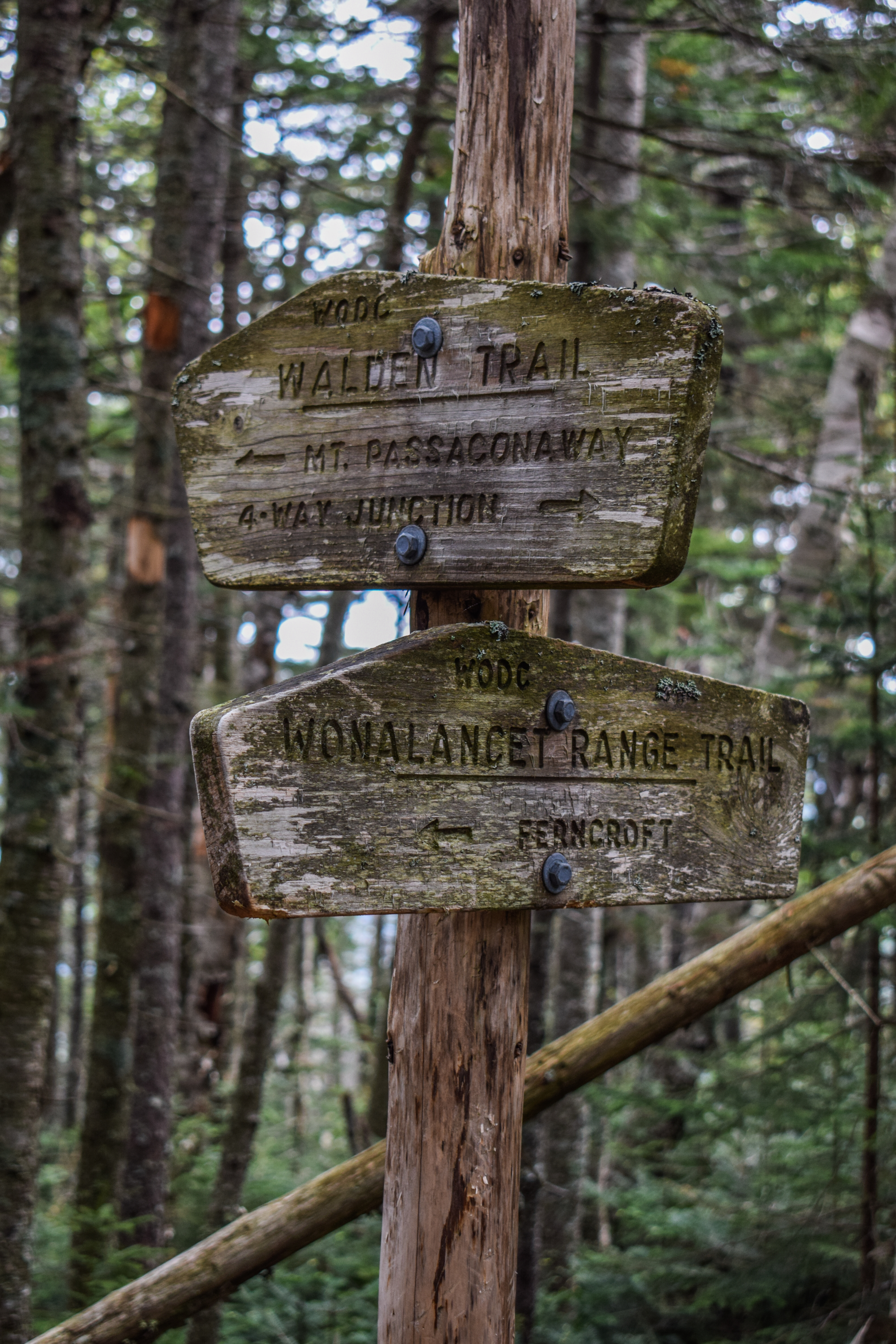
After Hibbard Mountain, the Wonalancet Range Trail continued through wonderful, windy woods, rising and falling and rising again, eventually traversing a nameless hump. After the hump, I had to play a game of Frogger with moose poop - it seemed like every moose in the Sandwich Range used this ~50 foot stretch of trail as their bathroom! It was comically ridiculous! Just after, the Wonalancet Range Trail ended at the Walden Trail.

[9:02am - Walden Trail]
The first stretch of "guidebook made me nervous" trail was the ledge going up Wonalancet Range Trail, the second was this upcoming descent! I knew it was supposed to be steep, eroded, and overall pretty dreadful with a "broken ledge" somewhere (what on earth could that mean?!). Worst case, I could always turn around and head straight up Passaconaway, so down I went! The Walden Trail gently rose through wonderful woods to a false summit of Wonalancet Hedgehog, marked by a large boulder, and then the actual summit of Wonalancet Hedgehog, also maked by a large boulder.
[9:09am - Walden Trail/Wonalancet Hedgehog]
Just after the summit, there is a spur on the right to a view down to Lake Winnipesaukee and the Ossipees. The guidebook said there would be a sign indicating the spur trail, but I did not see one. The view was nice, but the ledge was very wet, so I did not tempt fate.


Back on the Walden Trail, I began to descend. The upper descent wasn't anything ridiculous, which I was grateful for. My tummy, though, was feeling WEIRD. I managed to find the next view spur, which was partway down a ledgy descent area and kind of obscure. The view, however, was wonderful! It showcased Mt. Paugus with Mt. Chocorua behind, and then the Moats and Kearsarge on the left. This would have also been a nice spot for a break, but I was more eager to finish up this descent.


After the view, the Walden Trail gets STEEP and eroded. I was grateful for some stone steps that would appear every now and then. The descent calmed briefly after this stretch and I could sort of make out the massive landmass behind me through the trees. I stopped for a quick potty break, and was happy to see my pee was crystal clear - cheers to hydration! I enjoyed observing how old blazes grow out - specifically how they spread as the bark on the trees grow, and I passed some porcupine poop!


Another large pile of moose poop marked the beginning of the next comically steep descent. I knew the trail was about to plummet because instead of seeing vast forest ahead of me, I saw just a few trees and then the sky - here we go! I lengthened my poles for this one, which was needed. I made my way down to a wet, rocky area, which in hindsight was definitely the broken ledge. The broken ledge looked worse than it was. It had many footholds and the only thing that really slowed me down was extra caution due to the moisture. If it were dry and I were ascending, it would have actually been pretty fun!

The sun began to shine more and more as I continued my descent, sometimes over wonderful stone steps and other times through tricky, rocky disasters. I eventually hit the final few stone steps which led to the 4-Way Junction! To the right was Old Mast Road, straight ahead was the Lawrence Trail, and to the left was Square Ledge Trail. I stopped here for a Nalgene swap, to take off my wind breaker, and to pound some honey roasted pistacios. It was now 50 degrees, and I got the first "bug-in-ear" of the day!

[9:55am - Square Ledge Trail]
The next step of my adventure brought me into the most remote-feeling (and actually remote) area of the day. The Square Ledge Trail immediately felt less-traveled as it continued to descend the drainage of the Oliverian Brook, which was just barely audible at times. The forest was beautiful - sunny, open, fern-filled and boulder-strewn with good footing and easy grades. There was a light breeze and all was peaceful until... BOOM. A limb fell from a nearby tree, scaring the living daylights out of me!

I pulled myself together and continued to have a wonderful time, only slightly lamenting the fact that I was continuing to descend after climbing 2000ish feet. The trail then rose, neared a brook, and crossed the aformentioned lovely, small brook. The sky was beginning to turn blue (I did feel a few isolated raindrops, which was confusing, but I know not to ask too many questions). I finished rising and the trail began to descend again before... rising again! Never at anything more than an easy grade though. Again, all was calm until...

I heard what could only be describe as the sound of Satan himself... burping? It was low and guttural and HORRIBLE. It sounded not close but not far away on the higher ground to the left of the trail. I stopped to listen for a moment (a fly chose this moment to fly into my mouth, which was a solid bummer), and then I heard it again. NOPE. GOODBYE. Again, if I know one thing, it's to mind my own business!

EDIT FROM THE FUTURE: After spending a good amount of time on YouTube listening to insane animal sounds in the northeast, I've concluded it was a mother moose "barking" at me. No owls that I found make such an insane sound, fishers are more of a screech, and it was definitely not a bear. I learned that moose do vocalise, but usually only during the fall rut EXCEPT for when mother moose feel danger is present. On one hand, I wish I looked a bit closer to maybe see her, but on the other hand, I'm still alive an mostly uninjured today so I should count my blessings!
Anyway, I slightly picked up my pace as I descended to a wet area and was delight to not see any mammalian prints in the mud. I could hear the sound of Square Ledge Brook drawing nearer, and soon I was at the Square Ledge Branch Trail junction and the crossing of Square Ledge Brook!
[10:34am - Square Ledge Trail/Square Ledge Branch Trail]
The brook crossing was nice and easy. The Square Ledge Trail continued to meander through flat forest and then began to gain elevation at easy grades alongside a dried up streambed. The trail crossed the streambed and began to climb more moderately. I soon was able to just barely make out a ridiculously high landmass ahead of me through the trees as the trail climbed up another dry, rocky drainage and turned right at an arrow.


Now, the climb was steep and rugged. The trail skirted the base of the ledge, which felt like a 1,000 foot rock wall straight up. There was a slippery scramble followed by more steep climbing that led to a tree view over to Nanamocomuck Peak, the peak along the Walden Trail between Wonalancet Hedgehog and Mt. Passaconaway.


Continuing up, there was a herd path on the right to a nice view of Mt. Paugus with a borderline terrifying drop-off. This view was not in the guidebook.
[11:00am - Square Ledge Trail/Square Ledge Lookout]
The trail climbed comically steeply some more, with an interesting high rock wall on the left. This area was so cool and I had no idea how to do it justice with my camera. It felt very unique and very remote. Eventually, the trail made a left turn with the former viewpoint on the right, which was in a nice open area and had an overgrown view to Mt. Paugus and another over to Wonalancet Hedgehog/Nanamocomuck Peak. It was time for peanut butter tortilla #2! I took a sit and snack, and also put some bug spray on my hair to keep the gnats away.

Following the lookout, the Square Ledge Trail continued steeply up and over the actual summit of Square Ledge, with one scramble on the way. The nearby moose population apparently also like to use this stretch of trail as their primary bathroom, it seemed. I noticed a peek-a-view to Passaconaway followed by a nice view to Wonalancet Hedgehog (I want to say, I expected hardly any views on this hike since both Hibbard Mountain and Square Ledge have been delisted from the 52 With-a-View, but I was delighted!).

The trail slightly descended and then began to climb again at more reasonable grades. I had my only fall of the day here - a horrifically ungraceful slip on a root while ducking under a blowdown. I managed to smash my knee on a rock while kicking my pole, which in turn smacked me in the forehead. Ouch.
At the next height-of-land, the Square Ledge Trail began to descend veering right, but another spur path veering left climbed up another ledge to a FANTASTIC view of Mt. Passaconaway, Nanamocomuch Peak, and Wonalancet Hedgehog nearby. Passaconaway looked especially fantastic as it towered above. I could also see Mt. Carrigain and other peaks in the Pemigewasset area. From another edge on this ledge was an obstructed view toward Paugus and Chocorua.


From here, I backtracked to the Square Ledge Trail and began to descend steeply, but not ridiculously, along the base of the ledge I was just atop. The trail descended to a wet spot and then ascended steeply to a shoulder where there was a neat view of distant Carter Notch.

The trail turned a corner and began to descend again. I could hear a barking dog in the distance which would either signal 1) a human, which would be the first I'd seen all day or 2) Satan is back. Unknowing which one it was, I continued my descent, soon arriving at the junction with Passaconaway Cutoff! It was nice to be making progress. I will say, though, the last stretch of trail, from Square Ledge Branch Trail to Passaconaway Cutoff, was definitely my favorite trail of the day. It was so wild, rugged, unique, and somehow NOT miserable either.
[11:35am - Square Ledge Trail/Passaconaway Cutoff]
The descend continued over "slippery ledges" (another guidebook stressor), which was moreso just eroded trail down to the bedrock that doubled as a stream. With poles, this stretch was no problem.

From the lowpoint, the trail began to easily climb, and I passed my first human for the day! It took 6.64 miles and 4 hours, 56 minutes of hiking. It was nice to see someone! She was training her dog to come to her for peanut butter whenever the dog sees a human - the dog did a great job! I also found out via New England Trail Conditions that it was her dog and another that were likely barking:
"My pup had a good day except for the one dog that we met. Both dogs were offleash and I called mine back to me. She turned around and headed my way and the other dog jumped her. I was so mad. My dog was unhurt but rather than being apologetic the person with the other dog told me that my dog was barking too much. Seriously? Your dog jumped my dog and while you are lecturing me your dog is lunging at me and my dog, and my dog and I are standing off trail waiting for you to pass. Mean people stink. Those two minutes were not fun but the rest of the day was great!"
The trail passed through an old logging camp site (I didn't notice any particular flat areas aside from the whole area that had an easy grade to it, so I'm unsure if I legally "saw" the old camp). After a nice meander, it was time to start climbing again!
The grades ranged from moderate to steep and were constant with no breaks. I had another scary fart as I observed a tree view up to Passaconaway - wild to think I was heading up there! I passed what I thought was an old slide track that had a view from the top of a scramble (according to the guidebook), but it looked overgrown and not worth it. No more than 5 more minutes down the trail, I came to the ACTUAL slide track and I DID scramble up and the view was exceptional! The northern Presidentials were in a cloud, but the rest of the world was wide open and beautiful. The Wildcats were shining exceptionally wonderfully, along with Mt. Tremont and Hedgehog.


I found the following exceprt about the slide on a document titled "LANDSLIDES OF THE WHITE MOUNTAINS" by Steve Smith:
"Nanamocomuck Slide (1938) This small, steep slide on the north side of Nanamocomuck Peak (3,340 ft.), a southeastern spur of Mt. Passaconaway, fell during the Hurricane of 1938. At the bottom it slid across the Square Ledge Trail, and subsequent editions of the AMC White Mountain Guide noted the crossing of the slide along the trail. This slide is notable for its steep ledges interspersed with deposits of crumbling, pebbly “rottenstone,” which can present treacherous footing for the climber."
Continuing along the consistently monotnous climb, I realized I had bent my pole during my head-smacking maneuver on Square Ledge. Ugh. This push was tough. There were a good amount of painted trilium to cheer me on, and eventually the trail began to level out. This was marked by another moose's pooping spot. Soon, the trail entered a flat, bouldery area, and descended slightly to meet the Walden Trail! I was so relieved to see it, I might have teared up a bit...

[12:17pm - Walden Trail]
The Walden Trail was much more rugged (and wet) than the Square Ledge Trail in this next stretch. It traversed over the contour line for a short bit before turning and beginning a steep, wet climb. There was one tricky scramble which led to the junction with the East Loop trail. I had flirted with hiking the East Loop trail for the purpose of maybe someday possibly redlining, but I was deeply uninterested. One, because I was tired, but also because I knew I wanted to ascend Walden and descend Dicey's Mill, and hiking the loop would have either meant I would have to do an out-and-back or do the loop in reverse, which I was uninterested in. I also saw person #2 here!


[12:22pm - Walden Trail/East Loop]
A wet, steep climb ensued. There was a tree view back to Wonalancet as I slowly made what I thought was the final push. There was a brief walking in break in a pretty forest before turning to see an unfortunate view of the summit cone of Mt. Passaconaway. After a brief dip, the trail climbed again.

There were a few peek-a-views to Chocorua and the Sisters before paralleling and then crossing a small stream. I got another reprive here, but then it was time for more steep, wet climbing! My lungs and legs were BEAT. I was feeling incredibly satisfied with my adventure, though. The trail hit a small, wet scramble, and then I passed human #3 as I was rudely staring at another scramble. There was another view of Mt. Chororua and the Sisters on top of this one, though!

I soon arrived at the southern outlook described in the guidebook, which had a very nice trailside view to Whiteface, The Bowl, and Wonalancet with the Ossipees and Belknaps behind. It was fun to be so far above Mt. Wonalancet now!

Now I had the final final final push to the top! Thankfully, it was a short final final final push and the trail soon flattened out to the east outlook, which had another, higher view to Paugus and Chocorua, plus some other peaks if you wiggled around some.
From here, I had a short traverse on soaking wet trails (classic) to the Passaconaway view spur!
[12:51pm - Passaconaway View Spur]
The trip to the view felt a bit like a punishment or a self-inflicted would. It hurt my soul to be descending again, but I knew the view was wonderful. The descent as a whole was easy to moderate and generally VERY muddy, but I had expected the entire hike to be super muddy, so I was thrilled! There was one tricky blowdown patch, then another where you had to treat the tree like a curtain, and then another where you had to squeeze between the two trees. Thankfully, the spur is short (it did NOT feel short coming down!), and soon I had arrived!

[1:00pm - Passaconaway View]
WOW. This was such a spectacular view. Potash and Hedgehog were straight down below followed by the peaks of the Swift River Valley (Table, Tremont, etc.). Then I noticed the massive Mt. Carrigain and the nearby Hancock on the left. I had hoped, but did not expect, to see Hale or Zealand, since that's where Sarah was hiking, but the Hancocks got in the way. The Franconias were on the far left, being sprinkled with a passing shower. On the far right were the peaks near the Maine border up to Carter Notch. The Presidentials were still in the clouds, apparently getting some more snow and ice! I also had the whole view to myself, AND it was sheltered from the wind!

I sat down to enjoy my peanut butter tortilla #3, a hard iced tea, and some peace and quiet. It was 46 degrees, but it felt lovely. Eventually, I stood up to start the return and noticed a suspicious cloud hanging overhead...

[1:26pm - Walden Trail]
Yes, this was the same cloud that I noticed over Franconia Notch. Oh well! It never became more intense than a heavy misting, which truly kind of felt good. The return trip back to Walden Trail felt super fast, and there was an impressively flooded stretch just before the terminus. With some careful poking-and-hopping, I was soon at the junction of the Walden Trail, Dicey's Mill Trail, and the Passaconaway summit spur.

[1:28pm - Passaconaway Summit Spur]
[1:29pm - Passaconaway Summit]
The summit spur was wet, but drier than Walden. I quickly scooted to the true summit, booped the cairn, and passed human #4 on my short trip back to Dicey's Mill Trail - he did not say hi back to me.

[1:31pm - Dicey's Mill Trail]
From the summit spur, I turned left onto my final and longest trail of the day - Dicey's Mill Trail! The first stretch was from the summit to the East Loop, which was wet but very manageable. The misty cloud had fully arrived, as the standing tree-views from the upper trail were super hazy. The initial descent was steep but it soon mellowed out as I crossed paths with a trio, and then a solo hiker, and then another trio wearing cotton shirts, and then another solo hiker who said "this was NOT the recommended way" (I told her the other way was much worse), then two guys eating sandwiches, and finally a women with two off-leash German Shepards. It was JARRING being back in the land of people! People aside, going downhill at relatively gentle grades did feel AMAZING on my tired legs.

[1:50pm - Dicey's Mill Trail/East Loop]
I swam upstream through the humans to the East Loop junction and then continued over a scenic, gravelly stream crossing. The trail continued to be a stream after this, but it was never muddy and the water did not penetrate my deteiorating formerly waterproof boots. I crossed paths with a hiking duo and then a trio, eventually giving up on counting humans.

[1:55pm - Dicey's Mill Trail/Rollins Trail]
Now at the Rollins Trail junction, I started the main descent. I caught up with a group who were not instinctively letting me by, but happy let me pass when I asked. I was doing my usual act of self-torment but flying down the descent, which was easy on this trail. Footing was great and rock steps were abundant - the amount of time that went into maintaining this trail must be impressive! The temperature quickly began to warm as I flew down the mountain, and I passed my first and only red trilium of the day!

Dicey's Mill Trail is about 98% downhill with a few very short, very easy stretches of uphill and OH BOY were my legs feeling those stretches! I was crossing paths with significantly fewer people at this point, which is probably due to in part the time of day but also the likelihood that many folks are doing the Whiteface-Passaconaway loop. Around the 10 mile mark, I did begin to feel "the bonk," but thankfully I was at the point of hiking mindlessly anyway. The sun came back out, at least!
I crossed the Wonalancet River on a well-trodden log and entered a long stretch of wonderful, flat land. There was an occasional breeze as I meandered about, just enjoying the pressure of gravity slightly off of my legs.

[2:37pm - Dicey's Mill Trail/Tom Wiggin Trail]
Next up was the Tom Wiggin Trail junction, which said "steep and loose" and "not recommended" under the trail sign. I wonder how bad it could really be? After the junction, the trail began to descend again, steepening as it joined and paralleled a stream. I saw two more lady slippers at the 12 mile mark and then the trail crossed the stream. Bugs were out and buzzing about, but still not biting, which was truly a miracle!

[3:04pm - Dicey's Mill Trail/Sandwich Range Wilderness]
[3:05pm - Dicey's Mill Trail/Blueberry Ledge Cutoff]
I enjoyed hearing some cascades through the trees as the Dicey's Mill Trail soon left the Sandwich Range Wilderness and the White Mountain National Forest, entering private land. Just after, the trail comes to a junction with a bridge that leads to the Blueberry Ledge Cutoff, which was fun to walk on for a photo before continuing with my escape.


Soon after, the trail leaves the woods and continues along someone's driveway - I am deeply grateful that they are fine with hikers on their property! The breeze on the driveway was wonderful, especially since it got my one and only bug bite here! 12.51 miles/8 hours and 25 minutes of hiking on June 1st in the Whites and only one bite - I'll take it!
[3:14pm - Dicey's Mill Trail/Blueberry Ledge Trail]
After briefly reentering the woods and continuing on Ferncroft Road, I passed the junction with the Blueberry Ledge Trail, and was soon back at the Ferncroft parking lot, enjoying the low view back to Mt. Wonalancet!

[3:21pm - End of Hike]
WOW. This hike was a really fun adventure and a bit of a doozy. I would have loved to also gotten to Whiteface, but there was no "easy" way down - the gentlest would have been via McCrillis, but that would have added many miles to my hike. I especially loved the Wonalancet Range Trail between Mt. Wonalancet and the Walden Trail, and I LOVED the Square Ledge Trail between Square Ledge Branch Trail and Passaconaway Cutoff. It was also fun getting two more delisted 52 With-a-View's and repeated in a 4000 Footer.

I changed in the parking lot and ran into the woman who said "this was NOT the recommended route" - she was apparently trail running down - yikes! I had a wonderful drive home, getting a Hooksett cheesestake for some nourishment, and was delighted to hit zero traffic on I-95!

Step-by-Step
- Park at Ferncroft trailhead.
- Start hike on Old Mast Road.
- At jct., turn left onto Wonalancet Range Trail.
- Follow Wonalancet Range Trail to summit of Mt. Wonalancet and then Hibbard Mountain.
- At terminus, turn right onto Walden Trail.
- At terminus, turn left onto Square Ledge Trail.
- At terminus, turn right onto Walden Trail.
- Near summit, turn right onto view spur.
- At view, turn around.
- At terminus, turn right onto Walden Trail.
- At terminus, turn left onto summit spur.
- At summit, turn around.
- At terminus, turn right onto Dicey's Mill Trail.
- Follow Dicey's Mill Trail back to car.
No comments:
Post a Comment