Saturday, February 19, 2022

[BACKLOG] Pack Monadnock (Marion Davis Trail & Auto Road)

Pack Monadnock (Marion Davis Trail & Auto Road)

Hike Type: Loop
Distance: 2.95 miles
Elevation: 1023 feet
Time: 1 hour, 37 minutes
Hiking Challenges: New Hampshire Fire Tower Quest


The Hike
It was officially the weekend that I was going to learn how to ski up in Vermont, so it only made sense to do some hiking on the way up. This day's mountain was Pack Monadnock. I chose this mountain because it would be my fifth New Hampshire fire tower, officially completing the NH Fire Tower Quest! There's more than five in the state, but only five are required for the patch. I definitely plan on visiting the rest. 
 
We had a chilly start at 15 degrees with some wind, but thankfully we were sheltered by most of the wind in the woods. Spikes were on right away and for the entirety of the Marion Davis Trail. Nice views of the sun rising through the woods and frozen streams were abundant. The trail climbed with relative ease, but of course many breaks were had. 
 
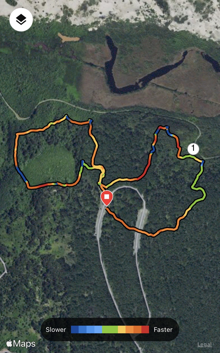
This mountain is also served by an auto road, so the summit was very developed. The firetower dominates the primary summit, but thankfully views are abundant in almost all directions and the summit has my favorite thing on earth - composting toilets!!We didn't spend too much time up top due to the cold wind, but we enjoyed every second. The fire tower structure was closed for the season, so I will definitely make a return trip to check that out. 


We weren't sure of what the condition would be on the Wapack Trail heading down, so to play it safe (and quick) we headed down the auto road. We were grateful to get views of what appeared to be an abandoned ski area across NH-101 and more impressively, Mt. Monadnock. The road switches between crunchy snow, sheet ice, and bare pavement which keeps us on our toes (and almost on our bums). 
 

Overall Pack Monadnock was a quick, easy hike, and I cannot wait to come back!


Step-By-Step
  • Park at Miller State Park parking lot and walk to the right of the sign to enter the blue-triangle-blazed Marion Davis Trail.
  • The Marion Davis Trail goes right to the summit without any junctions, enjoy!
  • After using the composting bathrooms and enjoying the views, descend via the auto road. 


Originally written and posted May 11th, 2022. 

Friday, February 18, 2022

[BACKLOG] Quincy Quarries Area (Blue Hills Reservation)

Quincy Quarries Area (Blue Hills Reservation)

Hike Type: Spaghetti Mess
Distance: 3.82 miles
Elevation: 250 feet
Time: 1 hour, 29 minutes
Hiking Challenges: Blue Hills 125-Mile Challenge


The Hike
What a MESS. What an interesting, sometimes scenic, MESS. I started this hike at the parking area off of Ricciuti Drive, and headed into the famous section of the Quarries covered in graffiti/art. This area is always so fascinating to me - what used to be a hot spot for cliff jumping is now a field with rock climbers, day drinkers, casual walkers, insane hikers, and drug users. You truly see every walk of life here, and all with a great view! This whole hike was littered with random unmapped, unmarked trails... and litter... so this hike can be summed up as "I did my best."

I first walked up to the highpoint of the main quarry, and then followed the road to the trails in the back. I never saw 4229, but the trail ends at the bottom of an old granit railway which was very cool. I did my best to guess which random trail was the junction at 4229 while I skirted around the quarry, and climbed up the back one. I hiked the random trails, doing my best to recreate the shapes on the map. The trail to the fields was slightly overgrown and ended with a torn-apart mattress. The trail returning to the parking area was unclear and eroded, but we made it back in one piece and only slightly scratched up. 


Once covering that area, I crossed Ricciuti Drive and entered on the spur path headed to 4238 and simply... did my best. Sometimes the trails in this area were clear, and sometimes I was just walking through the woods and getting scratched by thorns. I hiked to where the "u" is in "Quarries Foot Path" on the map, turned back towards Ricciuti Drive, and hiked towards 4236, which was the only clear area on this whole hike. The split just south of 4236 is also clear. I was able to easily get down to 4235, and that is where clarity stopped. I scrambled down a loose granite mess, walked in a few circles, and then made my way back to 4236. The trail at 4236 that does not go towards 4235 starts off easy to follow, then climbs to another quarry area, and then becomes a guessing game. I tried forever to find a semblance of a trail that leads to the southern portion of the Quarries Foot Path, but eventually had to abandon that plan. I followed something that could have been a path and hiked Northwest along the word "foot" on the map, but ended up lost in the woods again. The rest of the hike followed this trend, and eventually it looks like I made every shape.

I hope that someday this area gets cleaned up, or at least blazed. Its such a cool area with so much history, but hiking these trails is an absolute hellscape. I had hiked some of these trails a while ago, so the map doesn't cover everything. What a time!


Originally written September of 2022.

Thursday, February 17, 2022

[BACKLOG] Brookside Farm Trails (Blue Hills Reservation)

Brookside Farm Trails (Blue Hills Reservation)

Hike Type: Lollipop Figure-8
Distance: 1.4 miles
Elevation: 102 feet
Time: 28 minutes
Hiking Challenges: Blue Hills 125-Mile Challenge

The Hike
A short jaunt through some frozen woods. There isn't much to write about for this hike, aside from noting that this is clearly a lesser used area of the Blue Hills Reservation. I parked at the parking lot, walked the paved road past the co-op farm, and then did my best to find the trails. The trails were either along flooded, frozen fields or thorny urban woods with not much to see. I am curious what these trails would be like in the summer months when the plants have time to grow out. I am grateful that it was still cold enough for the ground to be frozen, because otherwise it would have been a wet end to the day. Either way, I was in an out in less than a half an hour and quickly on the way home!


Step-By-Step
  • Park at parking lot, walk toward 1057.
  • At 1057, first find short path that leads to private property, backtrack, and then follow the loop trail toward 1079.
  • Follow the shorter route to 1077.
  • At 1077, hike the remaining portion of trail back to 1079.
  • Re-hike the shorter route to 1077.
  • Follow road back to car.


Originally written Septermber 30th, 2022.

[BACKLOG] Final Chickatawbut Area Trails (Blue Hills Reservation)

Final Chickatawbut Area Trails (Blue Hills Reservation)

Hike Type: Lollipop Loop
Distance: 2.5 miles
Elevation: 682 feet
Time: 52 minutes
Hiking Challenges: Blue Hills 125-Mile Challenge; Toilet Paper Trio Winter

The Hike
A short hike to clean up the final trails of the Chickatawbut Area! Also, a hike through three different seasons. I parked right at the intersection of 28 and Chickatawbut Road (which I think is my least favorite parking area due to traffic... maybe its tied with the Quincy Quarries parking), and headed down the red-dot route. I got a little turned around at the area with 1000 different intersections, but landed on Glover Path, which is where I needed to be. At this point I hiked through muddy spring and dry fall, and at the next turn I was to discover some more winter too! I completed the Hawk Hill Path and took the Bouncing Brook Path to complete the lollipop. It was a short easy hike, and I did appreciate the different seasons - it kept things interesting!


Step-By-Step
  • Start hike at Route 28/Chickatawbut Road parking (3024).
  • Follow red-dot route.
  • Go straight through the Skyline jct., and then take the second right. At 3040, turn left onto Glover Path.
  • At 3044, turn right onto Hawk Hill Path.
  • At 3005, turn right onto Pipe Line.
  • At 3011, turn right onto Bouncing Brook Path.
  • Retrace steps back to car.


Originally written September 30th, 2022.

Wednesday, February 16, 2022

[BACKLOG] Lower Fells Reservation (Middlesex Fells Reservation)

Lower Fells Reservation (Middlesex Fells Reservation)

Hike Type: Loop
Distance: 3.2 miles
Elevation: 719 feet
Time: 1 hour, 20 minutes
Hiking Challenges: 52 Hike Challenge


The Hike
This hike was my first time in the Fells, and it felt like a great introduction! In hindsight, this was also right at my beginning of "after school hikes" - which ended up being one of the best things that I've started doing. I found this loop on AllTrails, and it was a great introduction hike with arguably the best view in the park. It started at the Quarry Road parking and followed the Skyline Trail for the first half. The trails were covered in a 1-3 sheet of soft snow, with a few icy spots I had to move slowly on, but nothing dangerous. The view from Wright Tower is truly excellent - you have the surrounding towns of Boston in the foreground, then downtown Boston, and then the Blue Hills in the background. The rest of the skyline trail on this hike followed a pretty rocky section with a few ups and downs.


The hike then leaves the skyline trail and follows some wide paths and narrow trails to wiggle back to the parking area, partially skirting past the reservoir with very confusing "no tresspassing" signs (I couldn't tell if it were for the trail or the shoreline or something else?) and I shared the trail with a friendly deer for a moment. Really peaceful hiking in a very populated area. I was back at my car in no time, and started my journey home. 


Originally written September 30th, 2022.

Saturday, February 12, 2022

[BACKLOG] Cape Cod National Seashore Trails

This is a series of seven different hikes along nine different trails, all apart of the Cape Cod National Seashore. Hikes will be listed in chronological order. All hikes qualified for my self-imposed "Cape Cod National Seashore Trails" Challenge, which is a challenge that I made up once I found a "Cape Cod National Seashore" patch on eBay - one has to hike all of the trails on the Cape Cod National Seashore.

Hike #1: Fort Hill & Red Maple Swamp Trails
Hike Type: Loop
Distance: 2 miles
Elevation: 101 feet
Time: 45 minutes

The day started out with a bang! We used the lovely vault toilets right at the parking area (which we're not sure if we were supposed to be at or not...) and followed the trail closest to the water first, as the sun was beginning to rise. We made sure to hike the trails on the NPS map that were marked, although there were more paths in the area. Right as we got a view of the water, the sun began to poke above the horizon - beautiful! We climbed the gentle hill and eventually dipped into the woods for the Red Maple Swamp Trail, which was a really nice boardwalk walk back to the car.


Hike #2: Buttonbush Trail
Hike Type: Loop 
Distance: 0.4 miles
Elevation: 52 feet
Time: 10 minutes

The next stop was the Buttonbush Trail at the Salt Pond Visitor Center. This trail is a trail specifically designed for folks with visual impairments, which made this easy trail very interesting. This area connects to the longer Nauset Marsh Trail, which Gen and I had hiked last year. We explored the visitor center a bit afterward, and then drove a little further in for our next hike.


Hike #3: Doane Loop
Hike Type: Loop
Distance: 0.6 miles
Elevation: 32 feet
Time: 14 minutes

This stop was more of a formality - we had previously hiked most of this area but for our self-imposed patch challenge we needed to clean up the rest of it. Very gentle, very paved, very big rock. Not much else to it. I guess technically some history, but we were too lazy to read into it. Next!


Hike #4: Atlantic White Cedar Swamp Trail
Hike Type: Lollipop Loop
Distance: 1.5 miles
Elevation: 128 feet
Time: 33 minutes

This was one of my favorite trails. We parked at the trailhead and first went over the ocean overlook, which had a decent drop off to the shoreline. Into the woods we followed a great boardwalk system through a beautiful cedar swamp. The return trail was on an old woods road with a gentle incline. 


Hike #5: Pemet Area Trails
Hike Type: Lollipop Loop-ish
Distance: 3.2 miles
Elevation: 525 feet
Time: 1 hour, 21 minutes

Now this was the pinnacle of "Cape Cod Hiking" of the day. The wewather broke into the low 50s, which meant it was shorts time! The trail starts by climbing Berberry Hills West and Easy summits, which offer great views of the area. We then took the side trail to the old Bog House that was a little spooky, and then began our hike on the great dune system. Where we hit 2 miles was a long trail that we couldn't find much infomation on - apparently there used to be an overlook a ways down, but I read it was well overgrown now. I also found a tick on me which sent me through a mini crisis - but we prevailed. The trip nearest the ocean is high up on the dunes and just spectacular. We concluded our hike by retracing out steps back to the car - just amazing!


Hike #6: Small's Swamp & Pilgrim Spring Trails
Hike Type: Figure 8 Loop
Distance: 1.3 miles
Elevation: 197 feet
Time: 33 minutes

We were officially in the upper cape! This was a combination of two loop trails that join at the trailhead. First was Small's Swamp, which was a nice easy loop around a swamp, sometimes on trail sometimes on boardwalks. There was one flooded section of boardwalk, but not enough to get our feet wet. There were some views towards the end.

Pilgrim Spring Trail was a bit longer and bit less used, but had some great views of the nearby wetlands and the ocean in the background. Even being on someplace as busy as Cape Cod, we really felt like we were the only ones around. It definitely helped that it was winter... Anyway, one more stop to go!


Hike #7: Beech Forest Trail
Hike Type: Figure 8 Loop
Distance: 1.1 miles
Elevation: 164 feet
Time: 1 hour, 19 minutes

The final stop for the day was all the way up in Provincetown - the Beech Forest Trail. We easily saw the most people of the day here. It first looped around Blackwater Pond, which was partially frozen over, and then had a secondary loop through some sandy woods. There was a side trail up to a tune with some cool other-worldly views. Once we finished we hit up Cumberland Farms, ate at Race Point Beach, and began our long drive home (we later realized we hit up every Cumbies on US-6 on the cape this day). Great day!


Originally written September 30th, 2022.

Thursday, February 10, 2022

[BACKLOG] Skyline Headquarters Loop (Blue Hills Reservation)

Skyline Headquarters Loop (Blue Hills Reservation)

Hike Type: Loop
Distance: 2.9 miles
Elevation: 1086 feet
Time: 1 hour, 24 minutes
Hiking Challenges: Blue Hills 125-Mile Challenge; 52 Hike Challenge


The Hike
One of my favorite hikes - the Skyline Loop! I parked at Blue Hills Park HQ, and quickly realized that I would need to use my brand new spikes (after I destroyed my other ones on Mt. Roberts and Hedgehog Mountain...). I went name brand this time, with the classic Khatoolas. So far, so good! This day was beautiful, yet icy. The weather was nice, but the ground was still hard. Traction was great with the spikes on! The only sketchy spot was that steep scramble heading up Big Blue after 1083. There was one massive dark cloud that zoomed by, but otherwise the sky was blue and the weather warm (for February). A great afternoon in the reservation!


Step-By-Step

  • Follow Skyline Trail clockwise from Park HQ.


Originally written October of 2022.