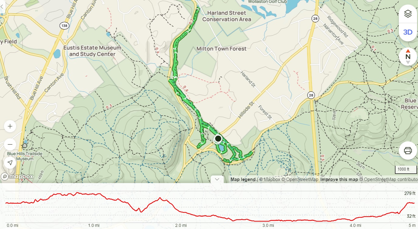
Mt. Roberts, Faraway Mtn., Mt. Shaw, Black Snout (Castle in the Clouds Conservation Area)
Hike Type: o-O Loop
Distance: 15.49 miles
Elevation: 2612 feet
Time: 7 hours (6 hours, 30 minutes moving)
Hiking Challenges: 52 Hike Challenge, 52 With-a-View, Ossipee 10, Castle in the Clouds Achievement
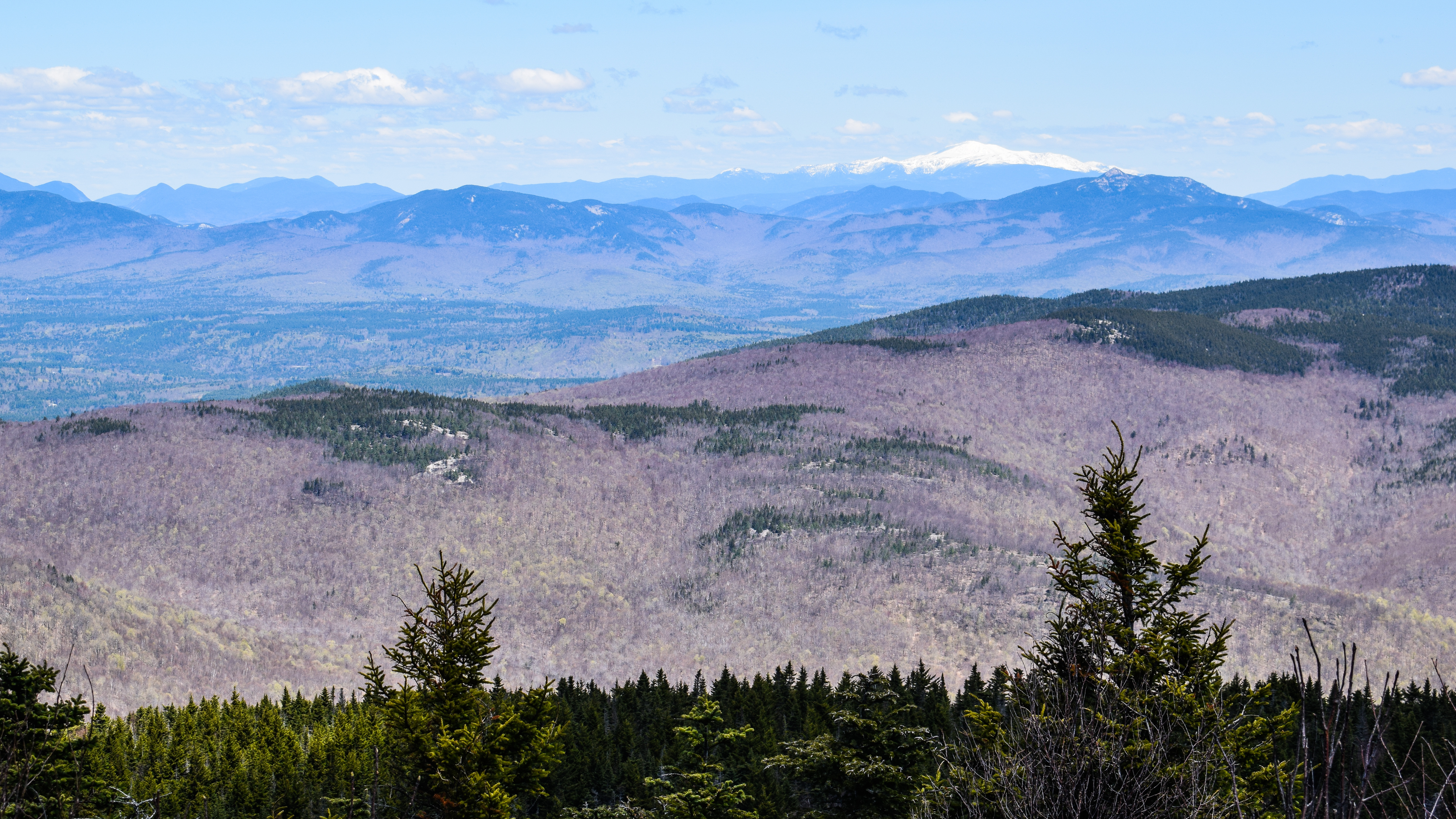
View from Mt. Shaw.
The Hike
I’m writing about this hike with a sore body the next day, sitting on my back deck for the first time all year. It’s been a long year so far, and I’ve gone through varying stages of crusty, notably the past couple of weeks. I’m forever working on finding the balance between rest, exercise, hobbies, and socializing, and I’m not there yet. What I’m getting at is that it’s been a rough past couple of weeks culminating in a brutal last few days (thanks full moon…) so I NEEDED to find myself in the woods by myself this weekend, and thankfully, I was successful!
The 4am alarm went off and I truly questioned my life choices, but I knew I needed this hike, even if I had only slept for four hours. I got all my things together, and started on my drive up north, naturally opting for I-93 so I could stop at the beloved Hooksett rest stop and spend way too much money on snacks and sustenance (and take care of my morning business, which was perfectly timed, thank you). One thing I have not figured out about this rest area is when they make breakfast sandwiches. I was sure since it was close to 6am they’d have something… nope. I’ve also been there around 4am and found sandwiches… who knows!
The sun began to rise once I left Hooksett and soon became blinding. The temperature was mild - hovering around the upper 30s or low 40s, and my excitement was growing as I fought off sleep. I opted for the Ossipees today since the north is going through some intense springtime melting, plus I still needed Mt. Shaw for my 52-With-a-View, plus plus I’m still flirting with getting the Ossipee 10 patch before the end of the year. I made my way to the parking area where there was only one other car far away, SLOWLY got everything together, and started my hike!

The first leg of my adventure was a repeat - the Mt. Roberts Trail to Mt. Roberts. This was my first ever winter hike - it was spectacular then and its spectacular now! Also relatively easy, which was nice. The trail is extremely well blazed and clear to follow, with an excellent view of Red Hill and surrounding lakes and hills about a mile in. The trail continues to climb the mountain, rarely steeply, and when steeply, a flat section is soon after. The views keep getting better on this trail, with three-ish open ledge areas, primarily aimed toward Lake Winnipesaukee and the Belknap Mountains - just spectacular. The traces of leftover snow on Gunstock Mountain where shining in the morning sun, and I was lucky enough to be all alone. I enjoyed my favorite hiking snack - mozzarella wrapped in prosciutto, from the second large ledge.

I continued on and was grateful for how dry the trails were, sans a few sections, but all very manageable. There were a few puddles higher up, but nothing crazy. The best view is from the highest ledge with a clear view of the lake, Belknaps, and the surrounding Ossipees (its cool to look at the photos and basically see my route for the day). It was clear that the streams were rushing because you could hear an impressive hum from the ledges, not sure if this is an omen or not…

An impressively large spider got me moving again, so I continued on. After the final open ledge the trail dips into a conifer forest where it was truly mud season. DEEP puddles of water and mud most of the way, with occasional patches of snow off in the woods. The temperature was much lower here, as well, likely due to how dense the forest is. I reminded myself that there’s 1,000 bailout points of the rest of my hike is like this, and slogged on. Thankfully there were plenty of birds singing their springtime songs to encourage me along. The Yankee Candle-scent to the air helped too.

The trail climbs up again and begins to transition back to a hardwood forest just before the summit where there is a spectacular view up to Mt. Washington, still very covered in snow, earning its name as the “White Mountains.” The radio/cell tower of Faraway Mountain, my next stop, was also visible. The most jarring view of all was when I looked down and saw that there was a gargantuan hole in my shorts, big enough to truly give birth through. Oh well! I’m in too deep now! Thankfully, I was wearing underwear. To my dismay, it was bright red.
The hike continued past the summit, now onto the High Ridge Trail, which would be my home for the foreseeable future. It started as a wide, open, dry road, and to my delight stayed that was for 90% of the 5+ mile trail. There were a few patches of snow, but the trail overall was very dry (I believe in the summer this trail and other wide carriage road type trails get very grassy, so I picked a great time). This stretch of hike was absolutely lovely and the only thing that could have made it better was bringing my visor to shield my translucent face from the brutal sun, but it was relaxing in my car.
Just before the trail to Faraway Mountain there is a bridge going over the head of the Shannon Brook, which was cascading beautifully. Soon after the trail parallels either a pond or seasonal wetlands, which were very pretty, but the trail was soaked and slushy, which gave me my first dose of wet socks for the day. At least it was pretty!

The turn off for the trail that leads to Faraway Mountain (not an official trail to my understanding) is extremely clear, and requires a quick dip under an old chain rope and passing some form of old machinery, maybe used to grade the carriage roads? I’m truly stumped on this one. The trail itself was fine, unblazed, and clearly less used, but easy enough to follow the whole time. There was a good amount of snow off-trail and some on-trail. Toward the end there were some spots with flagging tape, but I found that to be unnecessary. This spur trip was beginning to feel like a slog, but then I was there! The summit is in a large clearing for a radio or cellphone tower, with truly no information or other infrastructure. I took a few photos and then returned back to the High Ridge Trail, which felt super quick.

The next stop on my hike was the “Faraway Lookout” which provided a nice view of Lake Winnipesaukee and the smaller Ossipees, but it wasn’t a great resting point. I did notice some of the branches around me had a thick, black, puffy something on them. Egg sacks? Disease? Fungus? Aliens? I need to check that out. Continuing along, I could soon see Mt. Shaw through the trees, and it looked, dare I say… Faraway???? Like silly far. I guess my hike is slated to be around 14 miles… Further down there is a looooong switchback/hairpin that crosses over a cascading stream (once on the upper trail and once after the turn - the second had a bridge that was currently flooded over and possibly eroding away, sketchy). Right at the hairpin turn I heard something, and I’m 98% sure it was a snowshoe hare! It had the summer coloration, but I’ve never seen a cottontail rabbit that big or with such large feet. Exciting! I tried poking around the woods to get a photo, but it hid perfectly.

The hike began to mentally slow down at about the halfway point. I crossed the Faraway Mountain Trail junction where it said there’s still 3.3 more miles to Mt. Shaw (after already being ~6-7 miles in), saw how far all the mountains were through the trees, and eventually made it to the Oak Ridge Cutoff junction, which was still 1.8 miles from Mt. Shaw. The significance of this junction is that I will be returning here to make my final return trip, in many, many miles. I passed my first person of the day almost 8 miles in, and things finally started perking up at the junction with the Turtleback Mountain Trail, where I passed a snowmobile gate and got a great view of an open swamp. I took a bunch of photos before finally making my final approach on Mt. Shaw.

The climb up to Mt. Shaw was monotonous, reminded me of the hikes up Mt. Tremper and Overlook Mountain in the Catskills. Wide access roads that had seen better days. The trail continuing up Mt. Shaw is also a snowmobile trail that has recently melted, making the footing tricky with loose soil all around. There were a few large snow patches leftover, and heartbreakingly, I saw a few patches of frog eggs that got washed away! I could see the Presidentials through the trees and their snowcapped majesty truly looked like clouds. Interestingly, I noticed a good amount of porous rocks on the ground, and I could feel that the soil underneath me was still partially solid, but quickly melting. It was an interesting climb, to say the least.

The High Ridge Trail comes to a junction not on the LRCT map with another snowmobile trail, and both climb up to the summit. I haven’t been snowmobiling since I was probably 4 years old in the Poconos, so it was very interesting for me to see all the informational signage that they use to navigate. Kind of like road signs, but on a mountain in the snow. This area leads to the junction with the Black Snout Trail, and then finally ascends to the summit of Mt. Shaw. The final bit of trail smells like a Christmas tree and opens up to a magnificent view of the northern Ossipees, a long valley, the Sandwich Range, the Presidentails, and dozens, if not hundreds of other known peaks. The only downside was that the wind was whipping and it was a small summit, so if anyone else came I’d have to move.

I had a beef stick and a protein bar before heading back down into the woods, passing some moose poop and a snake! I crossed another snowmobile gate to join the Black Snout Trail, and continued on my journey. I started to pass a few people at this point, many of whom I believe were just pairing Black Snout and Mt. Shaw. There was some confusing signage that may have implied the High Ridge Trail and Black Snout Trail ran concurrently, but no maps agree with that. The Black Snout Trail was easy and straightforward, coming to a junction where the main trail descends and a spur leads to the summit.

The spur to the summit was quite lovely with nice views toward Lake Winnipesaukee and smaller hills. The plants along the trail were beginning to bloom and they smelled fantastic! There were also some more mysterious black blobs. I had the realization that I was tired, but still feeling pretty good. This hike was big miles, but they were quick miles. The summit of Black Snout has an obstructed view back toward Mt. Shaw and a slightly more open view toward Lake Winnipesaukee. It was a slightly larger summit area where I took some time to rehydrate and snack some more before beginning my LONG return to the car.


Now descending along the Black Snout Trail, I noticed there were a few blazed, unmapped trails along the way (there was another one coming off Mt. Shaw) that I think are linked to the infamous Trail Bandit map. I’m hoping I’ll remember to download some of the articles to link here, because it’s a very interesting saga. The trail itself was on par with every other trail of the day - wide, gentle, and relatively dry. I played leap frog with someone I had passed twice before now who commented this was a “one in a million day.” It was quite lovely outside.

I neared the end of the Black Snout Trail when I heard truly my all-time favorite sound, peepers! The frogs were singing loudly in a small pond, but sadly got quiet as aI got closer. I planned to go back to High Ridge, then Oak Ridge Cutoff, and the Bridle Paths down, but I also flirted with the possibility of taking the Turtleback Mountain Trail down and adding one more peak for the day… UNTIL I saw the sign with mileage. Plan A would be about 3.5 miles, plan B would be 5.3 without the spur to the summit, and I was already at 11 miles, so plan A it is!
I was glad I went with plan A because I got another great look at the wetlands/swamp/pond from before, and I didn’t realize that it was COVERED in frog eggs. I’m jealous of whoever will be there in a few weeks when there’s tadpoles taking over the world! I retraced my steps along the High Ridge Trail to the Oak Ridge Cutoff, and then officially stared my descent.
These mountains really decided my day had been too easy, to they revved things up for the descent. Oak Ridge Cutoff was steep and rocky up top, and then dreadfully wet and muddy around the middle. Even though it wasn’t, it felt like my slowest mile yet. I had to rock hop the whole way because every bit of ground, even if it appeared dry, was at least 3 inches of mud. Dreadful.
I was relieved then cranky again when I made my way to the Upper Bridle Path. I’m not sure that anyone’s been on this trail in the past 30 years? It was blazed excellently, which was vital since there was barely any footbed, if any at all. The trail climbs over a couple knobs, which made me angry, before descending steeply and ruggedly. There was one partial view through the trees of Turtleback Mountain (I think), but overall it was featureless. The only thing that made me happy at this point was that the forest was much greener now that I was getting down in elevation. Also… what even is a bridle path?

I had a short stint on the Faraway Mountain Trail before then skirting onto the Lower Bridle Path, which was MUCH nicer. Clear footbed, still more rugged than the carriage roads, but a very nice trail. I was cranky, I was chafing, and I was tired, but there’s was a spur to a lovely view of Lake Winnipesaukee (who I was even getting tired of at this point). I could feel a couple blisters forming (I should have packed an extra pair of socks whoops), but thankfully I was almost done!

I caught myself singing “I am Slowly Going Crazy” by Dr. Jean for the last mile or so, and eventually completed my hike at Shannon Pond, where there was an impressive washout from recent flooding. There were a few trail closures, which I didn’t realize until after I left the trail paralleling the pond… which was a closed trail… sorry. I cut across the soggy lawn and made it to my car for my quick change and go! There were plenty of cars now that it was early afternoon. It was a long hike - my longest solo hike to date in terms of miles and possibly time, but it was fantastic! I’m excited to keep working on my Ossipee 10 and my trail tracing patch for the area (Lakes Region Conservation Trust Castle in the Clouds Achievement Patch - quite the mouthful).
Step-By-Step
- Park at "i2" hiker kiosk parking.
- Start hike by road walking toward the Mt. Roberts Trail, staying left.
- Enter woods on Mt. Roberts Trail (orange blazes).
- Summit Mt. Roberts.
- Continue along onto High Ridge Trail (blue blazes).
- At next junction, turn left onto trail to Faraway Mountain summit (unblazed). Retrace steps.
- Turn left back onto the High Ridge Trail (blue blazes).
- Summit Mt. Shaw.
- Retrace steps along High Ridge Trail to next junction.
- At next junction, turn left onto Black Snout Trail (white blazes).
- At next junction, continue straight to summit Black Snout (white blazes).
- Retrace steps, then turn left to descend Black Snout Trail (white blazes).
- At next junction, turn right onto Turtleback Mountain Trail (yellow blazes).
- At terminus, turn left back onto High Ridge Trail (blue blazes).
- At next junction, turn left onto Oak Ridge Cutoff (white blazes).
- At next junction, turn left onto Upper Bridle Path (green blazes).
- At terminus, turn left onto Faraway Mountain Trail (orange blazes).
- At next junction, turn right onto Lower Bridle Path (green blazes).
- At sign, hike up to vista and continue along Lower Bridle Path.
- At terminus, follow perimeter of Shannon Pond and return to car.
"Black Snout Trail" from Lakes Region Conservation Trust Castle in the Clouds Map (2017)
Black Snout is a high shoulder of Mt. Shaw. The trail starts 5.2 mi up the Tutleback Mtn Trail. It leads 1.7 mi. to Black Snout, which has great views of Lake Winnipesaukee and peaks to the S, E, & W, or in 2.1 mi to the summit of Mt Shaw via the High Ridge Trail where there are superb views to the N, E, & W.
"High Ridge Trail" from Lakes Region Conservation Trust Castle in the Clouds Map (2017)
This trail, a carriage road, runs for 5.3 mi in a southeasterly direction across the highest ridge in the Ossipee Range. It connects the summits of Mt Roberts and Mt Shaw. It is always at elevations of over 2300', but consists of easy to moderate grades along its entire length. To reach this trail you must first complete one of the several other trails that lead up to the ridge.
"Lower Bridle Path" from Lakes Region Conservation Trust Castle in the Clouds Map (2017)
This 1.0 mi trail starts behind the Shannon Pond Kiosk and connects SHannon Pond with the Faraway Mountain Trail. A fine view of Lake Winnipesaukee is available from a viewpoint along the trail.
"Mt. Roberts Trail" from Lakes Region Conservation Trust Castle in the Clouds Map (2017)
From the Upper Trailhead Kiosk, walk toward Shannon Pond and follow the left fork of the paved road toward the barn with the red roof. Keeping the barn to your left, head for the corner of the fenced-in-field where it almost meets the woods. At that corner, you will find the trailhead for the Mt Roberts Trail. It follows Roberts Ridge for 2.5 mi to the summit of Mt. Roberts, often across open ledges that provide grand views southerly across Lake Winnipesaukee. At the summit there are great views of the White Mountains to the north.
"Oak Ridge Cutoff" from Lakes Region Conservation Trust Castle in the Clouds Map (2017)
This 1.0 mi trail starts 0.5 mi up the Faraway Mtn Trail and goes NE across the Oak Ridge to the High Ridge Trail. About 0.5 mi up, there is a junction with the Upper Bridle Path Trail. The Oak Ridge Cutoff provides quicker access than the Turtleback Mtn Trail to the summits of Mt Shaw and Black Snout.
"Upper Bridle Path" from Lakes Region Conservation Trust Castle in the Clouds Map (2017)
This 0.75 mi trail starts 0.25 mi up the Faraway Mtn Trail and goes across the Oak Ridge to its end at the Oak Ridge Cutoff. There are fine views of Lake Winnipesaukee along the way.
***
"Ossipee Mountains" from Southern New Hampshire Trail Guide, 5th Ed. (2021)
These mountains, just northeast of Lake Winnipesaukee, occupy a nearly circular tract about 9 mi. in diamater. They are the result of an unusual geologic formation called a ring dike, in which magma wells up into a circular fracture in the earth's crust. The range shelters beautiful Dan Hole on its southeast edge and harbors areas of old-growth forest and great diversity of vegetation, including several rare species.
Mt. Shaw (2,990 ft.), the highest of the Ossipees, affords outstanding views north toward the White Mtn. and other mountains to the east from its partly cleared summit; it may be ascended by a combination of trails in the Castle in the Clouds Conservation Area. A southern shoulder, called Black Snout (2,803 ft.) offers excellent vistas to the south and west, particularly of Lake Winnipesaukee. (This is not the Black Snout shown on USGS maps, which is at the north end of the range and is not reachable by any trails.) The rocky promontory Bald Knob (1,880 ft.) also provides fine views of Lake Winnepesaukee. Other outlooks are on the south slope of Faraway Mtn. (2,783 ft.), at the summit and on the south ridge of Mt. Roberts (2,584 ft.), on Turtleback Mtn. (2,205 ft.), and on Oak Ridge.
The 5,381-acre Castle in the Clouds Conservation Area, owned and managed by Lakes REgion Conservation Trust, encompasses most of the south slopes of the range, including all the summits listed above. (No admission is charged to enter the estate grounds, but there is a fee for a guided tour of the mansion on the site, called Castle in the Clouds.) LRCT has created more than 30 mi. of trails, marked with paint blazes and diamond markers. Many of these routes were originally carriage roads a bridle paths built in the late 1800s and early 1900s when the area was a private estate, owned first by Benjamin Shaw (for whom Mt. Shaw is named) and later by the eccentric millionaire Thomas Plant. These routes are now available as public hiking trails. LRCT has published a topographic trail map (created by AMC cartographer Larry Garland) showing these trails; it may be purchased from LRCT. Sections of the LRCT trail system are shown on the Ossipee Mtns. maps in this guide. Several other blazed trails lead off the LRCT property onto adjacent private land, some of which may be posted against trespassing these trails are not maintained by LRCT and are not described in this guide or shown on the LRCT trail map. Use them only if you have obtained permission from the landowner.
Two hiker parking areas provide trailhead access. The large Shannon Brook trailhead parking area, with a kiosk an dwell marked by signs, is on LRCT land on the south side of NH 171 in Moultonborough, 0.2 mi. east of the main entrance to Castle in the Clouds and just east of the junction with Severance Rd. The second parking area, on Ossipee Park Rd., is just outside the gate to the estate grounds and is convenienet to several trails; Ossipee Park Rd. leaves NH 171 0.5 mi. southeast of its junction with NH 109 and rises steeply for 1.3 mi. to the signed parking area on the right. Drivers should be alert for tractor-trailers going to and from the spring-water bottling plant near the gate. (If this fairly small upper parking area is full, hikers must use the lower lot on NH 171.) To reach th emajor trail junction on the estate grounds near a kiosk at Shannon Pond, walk up the paved road past the gate. In 0.1 mi. turn right at a T intersection, and then soon turn left onto a gravel road that crosses a dike at the south end of the pond, reaching the kiosk at 0.2 mi. from the parking area. (Another 125 yd. ahead on the paved road, beyond th eleft turn, is the upper end of Brook Walk.) LRCT requests that hikers not park on the estate grounds inside the gate, as the access road gates are locked from late afternoon through midmorning during summer an dfall, and at all times in winter and spring. No camping, overnight use, fires, or wheeled vehicles are permitted on LRCT land. A few of the trails receive heavy snowmobile use in the winter. These trails may be indicated by orange arrow signs at turns.
The carriage road trails are generally wide with easy grades; the amount of vegetation on the trail may vary. Several connecting paths make possible a variety of rewaring loop hikes. LRCT offers a Hiker Achievement Patch for those who have climbed five summits on the property (Bald Knob, Black Snout, Mt. Shaw, Mt. Roberts, and Turtleback Mtn.) and have hiked all ninteen designated trails, totaling 30 mi., that lie within the property. For more information, visit lrct.org.
"Bridle Path" from Southern New Hampshire Trail Guide, 5th Ed. (2021)
This green-blazed trail, consisting of lower and upper sections, ascends along Oak Ridge, passing two outlooks. Lower Bridle Path begins behind the kiosk by the east shore of Shannon Pond and ascends easily on an old and sometimes muddy road, with one short bypass to the right. It crosses Oak Ridge Trail at 0.3 mi., and at 0.5 mi. it turns right. Here, a spur path diverges left and climbs 0.1 mi. by switchbacks to a ledge with a view of Lake Winnipesaukee. The main trail descends gradually north to a low spot and then ascends slight to Faraway Mtn. Trail for 0.1 mi, where Upper Bridle Path diverges right 30 yd. beyond a 90-degree right turn. Becoming roughest, Upper Bridle Path ascends moderately up the ridge, passing an outlook on the right at 1.4 mi. At 1.6 mi. it gains the crest of the ridge and crosses several minor humps before ending at Oak Ridge Cutoff, 0.5 mi. above that trail's junction with Faraway Mtn. Trail.
"Oak Ridge Cutoff" from Southern New Hampshire Trail Guide, 5th Ed. (2021)
This white-blazed trail connects Faraway mtn. Trail, 0.5 mi. north of Turtleback Mtn. Trail, with High Ridge Trail, 1.7 mi. west of Mt. Shaw. Oak Ridge Cutoff forms part of the shortest route from the Shannon Pond area to Mt. Shaw and Black Snout. From Faraway Mtn. Trail, Oak Ridge Cutoff climbs moderately northeast along the west side of Oak Ridge on an old woods road; then it swings right (east) and at 0.5 mi. passes a junction with Upper Bridle Path on the right. It continues, climbing moderately and meets High Ridge Trail via either of two short branches.
"Mt. Shaw (2,990 ft.)" from Southern New Hampshire Trail Guide, 5th Ed. (2021)
Mt. Shaw is the highest peak in the Ossipee Range and the entire Lakes Region. Its partly open summit offers a panoramic vista of the White Mtns. and western Maine. The route described below uses a combination of trails that follow woods roads and old carriage roads. It leaves from the hiker parking area at the top of Ossipee Park Rd. Grades are easy to moderate, and footing is generally smooth along the old roads.
"High Ridge Trail" from Southern New Hampshire Trail Guide, 5th Ed. (2021)
This blue-blazed trail follows carriage roads along the crest of the range between Mt. Shaw on the southeast and Faraway Mtn. and Mt. Roberts on the northwest. The amount of vegetation on the trail may vary, depending on how recently the trail was cleared and how much foot traffic it has received. Grades are mostly easy. At its southeast end, High Ridge Trail makes a short loop around the summit of Mt. Shaw; the viewpoint is on the north end of the loop. At the southeast side of the loop, yellow-and-red-blazed Gorilla Trail diverges. This rough, rocky path is not maintained by LRCT and is not shown on the LRCT or AMC trail maps; in 1.2 mi. it leads onto private land and then rises to the ledgy summit of Mt. Flagg (2,390 ft.), with excellent views, at 1.4 mi.
From the loop at the summit of Mt. Shaw, High Ridge Trail descends south by two switchbacks to its junction with Black Snout Trail at 0.4 mi. Here, High Ridge Trail turns sharply right as Black Snout Trail continues ahead. At 0.6 mi. High Ridge trail turns left where a snowmobile trail continues ahead. It descends to a junction with Turtleback Mtn. Trail on th eleft by a stagnant pool at 1.1 mi. Here, High Ridge Trail turns right and meanders along the ridge. At 1.5 mi. the trail turns sharply right (north) and follows the contour of the west side of a knob, passing a junction with Oak Ridge Cutof fon the left at 1.7 mi. After crossing a saddle, High Ridge Trail swings left (west) around the north side of a knob, descends to another saddle, and ascends easily to a junction with Faraway Mtn. .Trail on the left at 2.9 mi. It angles upward along the east side of Faraway Mtn.'s south ridge and then makes a hairpin turn left (south) and curves back to the right, reaching Faraway Mtn. Lookout at 3.8 mi, where there is a good view south over Lake Winnipesaukee.
High Ridge Trail swings north through boreal forest, passes an old road diverging right, and curves around the ravine at the head of Shannon Brook. At 4.3 mi. it swings right and crosses a bridge over Shannon Brook. It descends to a saddly and then climbs by switchbacks to a 0.2-mi. loop around the summit of Mt. Roberts at 5.2 mi. The left branch of the loop leads 60 yd. to a good view north to the Sandwich Range and Mt. Washington, visible beyond Black Snout. The right branch of the loop reaches the upper terminus of Mt. Roberts Trail in 110 yd.
"Mt. Roberts (2,584 ft.)" from Southern New Hampshire Trail Guide, 5th Ed. (2021)
Mt. Roberts is one of the most popular hikes in the Lakes Region, offering spectacular vistas over Lake Winnipesaukee from its open south ridge, which Mt. Roberts Trail traverses. A side path on the ascent leads to a good viewpoint west, and an outlook near the summit provides views north to the White Mtns.
"Mt. Roberts Trail" from Southern New Hampshire Trail Guide, 5th Ed. (2021)
Starting on the Castle in the Clouds grounds, this orange-blazed trail ascends Mt. Roberts via its ledgy south ridge. The route offers several excellent outlooks and passes through an unusual and extensive forest of scrub oak. Grades are moderate. From the trailhead parking area at the top of Ossipee Park Rd., walk around the gate and proceed up the road until you reach a T intersection at 0.1 mi. Bear left here. In another 85 yd. continue straight up a gravel driveway where the paved road (the start of Cold Spring Trail) swings right. Follow the driveway for 100 yd. When the driveway bears left to the stables, continue ahead across a field for 75 yd. to where Mt. Roberts Trail (blazes and sign) enters the woods.
The trail follows an old bridle path, bearing left at a fork at 0.4 mi. from the parking area, where Settlement Trail diverges right. Mt. Roberts Trail ascends for a short distance and then swings right across the top of a field (view) and onto a short relocated section. In another 50 yd. the trail turns right, going back into the woods. It ascends moderately, levels out, and descends slightly. At 0.8 mi. it turns right onto an older route of the trail. The grade is easy across a shoulder, and then the steadier ascent begins. At 1.2 mi. a spur path leads 70 yd. left to a fine view west. Here Mt. Roberts Trail swings right (nrotheast) and climbs steadily, reaching the next outlook at 1.6 mi. It continues up the ridge, alternating between scrub oak forest and open ledges with fine views south over Lake Winnipesaukee and east to Mt. Shaw (Note: Follow the blazes and cairns carefully across the ledgy areas, as it is important to avoid ecologically sensitive areas.) Mt. Roberts Trail reaches the highest open ledge at 2.3 mi. Here, it enters conifer woods, descends briefly, and then climbs moderately to the west end of blue-blazed High Ridge Trail, which makes a 0.2-mi. loop around the summit of Mt. Roberts. (Follow the loop 100 yd. to the right to reach a fine outlook north to the White Mtns.)
"Black Snout Trail" from Southern New Hampshire Trail Guide, 5th Ed. (2021)
This white-blazed trail follows carriage roads along the southwest side of Mt. Shaw, connecting with several other trails and providing access (via a spur path) to fine views from Black Snout. Its west end diverges to the east from Turtleback Mtn. Trail, 0.2 mi. south of High Ridge Trail. Black Snout Trail climbs by switchbacks and then turns right and traverses southeast across the slope, passing the junction with the red-blazed Mt. Shaw Trail on the right at 1.0 mi. (This trail, not maintained by LRCT and not shown on the LRCT or AMC trail maps, leads down to private land and should not be used without landowner permission.) At 1.2 mi. Black Snout Trail swings to the left; here, a spur path on the right follows an old carriage road 0.3 mi. at easy grades to a short loop at the summit of Black Snout, where there are fine views west and south. At 0.2 mi. from the main trail, the spur passes blue-blazed Ball Mtns. Trail on th eleft. (This trail, also known as Banana Trail, is not maintained by LRCT and now shown on the LRCT or AMC trail maps. It descends onto private land and should not be used without landowner permission.) A few yards beyond the junction with the spur, Black Snout Trail passes the start of obscure, yellow-blazed Thunderbird Trail (which also descends onto private lands, is not maintianed by LRCT, is not shown on the LRCT or AMC trail maps, and should not be used without landowner permission) on the right. It then ascends northeast to its junction with High Ridge Trail at 1.5 mi.; from here, it continues straight and reaches the summit of Mt. Shdaw in 0.4 mi.