Sunday, June 18, 2023

Mts. Avalon, Field, Willey, & Tom (White Mountain National Forest)

Mts. Avalon, Field, Willey, & Tom (White Mountain National Forest)

Hike Type: Three-Stem Lollipop Loop
Distance: 10.68 miles
Elevation: 3,455 feet
Time: 6 hours, 49 minutes (6 hours, 21 minutes moving)
Hiking Challenges: 52 Hike Challenge; New Hampshire 48 4000-Footers; 52 With a View


The Hike
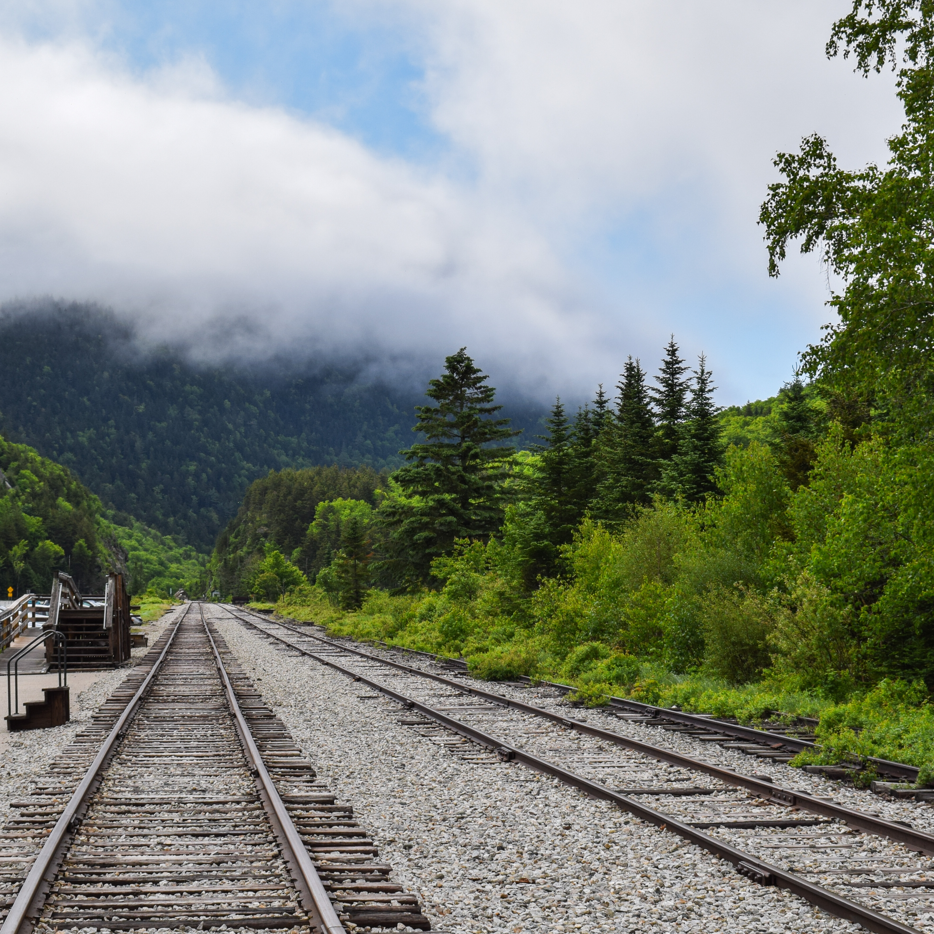
My weekend in Vermont’s Northeast Kingdom was officially over and it was time to take the scenic route home! I left Vermont a bit before 6:30am and made my first stop at the Littleton Walmart as my body was ready to expel all of the sins ingested in the past 48 hours… at least I’m consistent? I stopped at the Crawford Path trailhead for its composting toilet as a “just in case stop,” may have ran into “Finding Philip” (as we know I don’t talk to internet celebrities during these sightings), and then finally landed at the Crawford Depot around 8:30am. The clouds were comically low (maybe 100ft. above the height of the notch?), the air was cool and wet, bugs were at bay, and my water bladder was leaking. Apparently I had bitten through the mouth nozzle… whoops! I was trying to keep my expectations low for the day - I know weather had been rough, I forgot to read the White Mountain Guide beforehand, and this would be my first solo 4000 footer(s)! I finally got my hike going around 8:45am.


I crossed the tracks, entered the woods, and waved “goodbye” to the Mt. Willey Trail sign, comically joking to myself that “maybe I’ll head up there at the end” (spoiler: I did not have the energy to do such). There was someone about 200ft. ahead of me who turned around at the Crawford Brook crossing, which was rock hoppable. I did have to think for a minute, but I made it through no problem. I was delighted to see that the bugs were still asleep, for now… (they stayed that way!) except for the slugs who were EVERYWHERE. I truly was worried I was going to commit a genocide with how many I was almost stepping on. Curious if it was because of the time of the year or because it had been raining or just for fun?


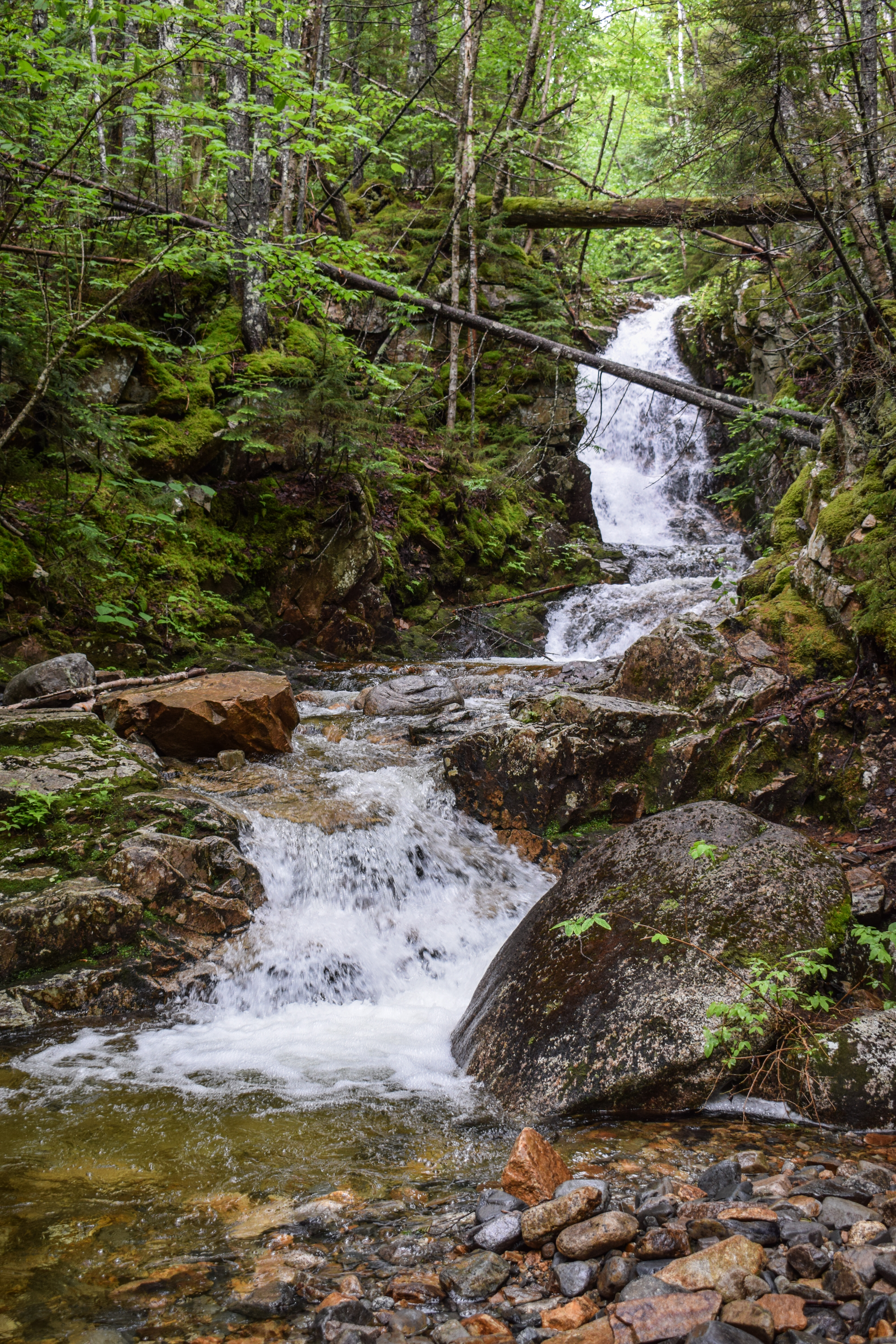
The Avalon Trail continued straight at a junction with the “Cascade Loop,” which looked short on the AllTrails map, and who doesn’t love cascades?? I made the left turn and was immediately delighted with my decision. The trail on the Cascade Loop is narrower and leads to two named cascades/waterfalls, “Beecher Cascade” and “Pearle Cascade,” both have herd paths that explore the riverbank to get different views from the cascades. The slugs painted the way along the trees to the end of the loop which connects back to the Avalon Trail, a bit further up.


The Avalon Trail from here continued onward, steadily and slowly increasing in grade. There were a few sections that were wet and muddy, but the kind of wet and muddy that is bearable (not like Stannard Lookout…). There are a few more cascades with herd paths to viewpoints along the trail and eventually a second brook crossing, which was also not a problem. The higher up I climbed the foggier the world became around me, and as the trail continued to get steeper, I saw the first major junction sign through the clouds!


The Avalon Trail turned left here as the A-Z Trail continued straight (I would return this way much later). I had read that the final push up to Avalon was a doozy, and the warnings were very correct. One of those steep sections full of boulders that make you giggle to yourself and think “why on gods earth did I CHOOSE to do this again?” It didn’t help that with all the rain, and literally being in a cloud, has left the whole trail soaked. Thankfully there were plenty of decent spots to put the feet so even though it was ridiculously steep and visibly dangerous, it never felt as such. 


Turning around, the likely would have been obstructed tree views, but I was deep into a cloud so all I could see were my immediate surroundings. Eventually the trail began to level out and continue towards another trail sign, signifying that the Avalon Summit was just 100 yds. away! Of course I took the spur path with the assumption and understanding that I would likely have no view.


The spur to Avalon was back to being steep with rough footing, and the last scramble before the summit was particularly comical. I think I grabbed onto a root and threw myself up on the ledge? Truly a mystery. To no surprise the view was of the inside of a cloud, so I found a sitting spot, plopped my soaking wet body down, and like magic the clouds parted just enough for me to get a daunting view of Mt. Field towering above me! It wasn’t nearly as magical as when the same thing happened to me on Mt. Crawford, but I’ll take my wins when I can get them! I enjoyed a slice of Parker Pie Pizza (the pizza stone, to be specific), and had my first of many encounters with a man I named “Gator,” from the Florida Gators shirt he was wearing (and thick southern accent).


Food was in the belly, shirt was rung out, clouds were back, and it was time to continue on! I followed a herd path around the silly scramble and almost instantly regretted it when I nearly grabbed onto a skinny tree trunk COVERED in slugs. Thankfully I survived, but that was almost the end. The Avalon Trail continued in the Field/Avalon col through some beautiful, mossy, wet but not bothersome woods. The flat walking break is short lived, because it soon begins steeply climbing once again. There were a few wet slabs I was nervous about, but thankfully they weren’t slippery. 


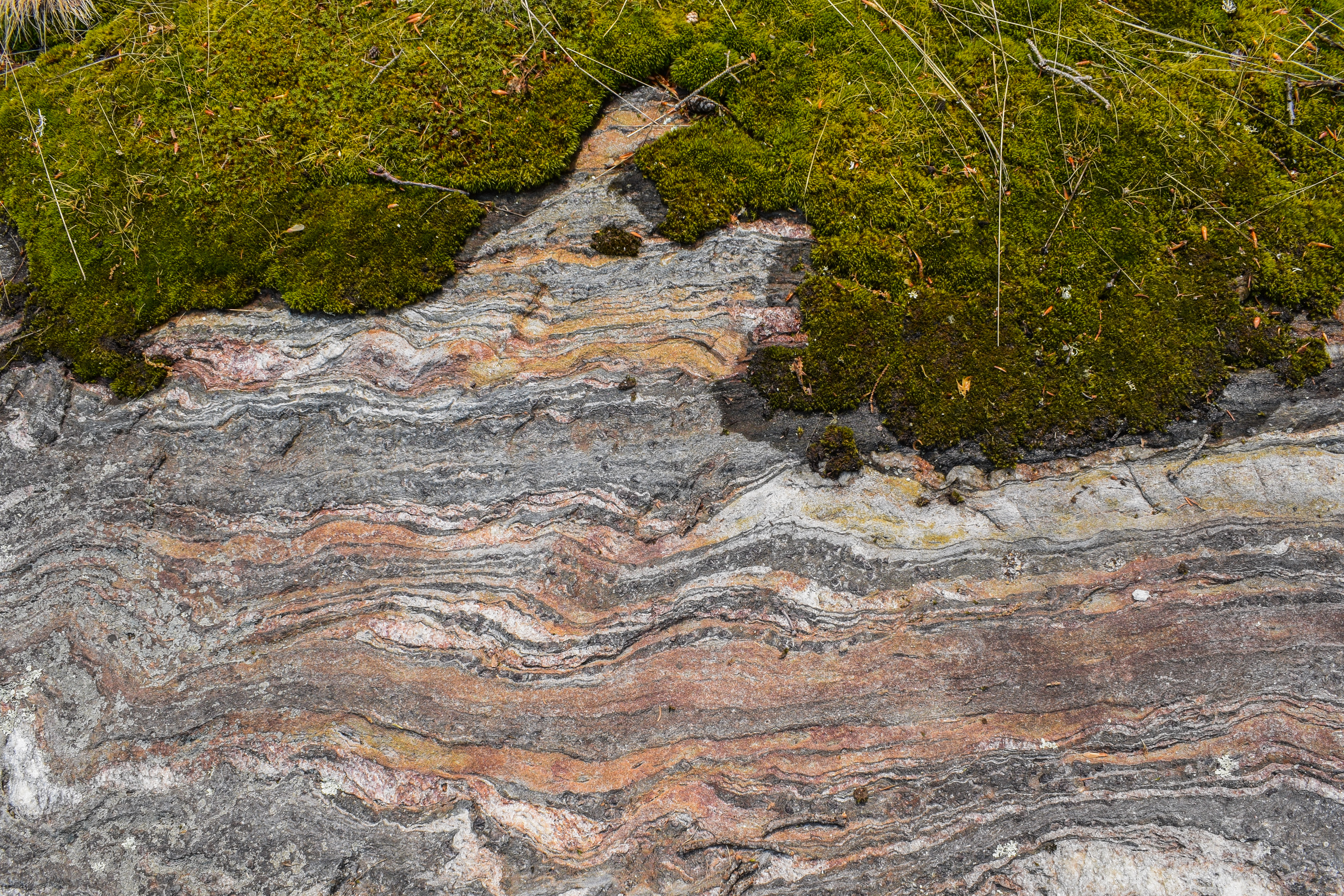
Higher up, the trail enters one of the more beautiful forests I’ve had the privilege of hiking through- truly the type of forest I believe authors imagine when writing fairytales. Gorgeous green mosses everywhere with a gentle bed of needles and soil on the ground, plus the scent that matches. I was in absolute awe! 


The trail continues to level out until it reaches its terminus with the Willey Range Trail. Turning left goes immediately to Mt. Field and later Mt. Willey, and right leads to Mt. Tom - I continued left, climbing quickly and steeply out of the enchanted forest to the summit of Mt. Field, which is marked by a large cairn in a medium-sized clearing.


It was evident there are usually some views off the summit (specifically one off a small spur on the left, and another looking back north along the Willey Range Trail), but as we all know by now, it was a cloudy day. Gator was at the summit and we commiserated about the lack of views, but he mentioned that he did Webster and Jackson last week in the rain, which is objectively worse for numerous reasons. I had a small snack before continuing on to high peak #2, Mt. Willey.


The trail gently meanders the summit “plateau” (if you can even call it that, more like the summit 200 sq. feet) and then immediately plummets into purgatory, or at least it feels like it. The trail was a stream up top and then entered an eroded, gravelly section that was truly a wild ride to get down. The only positive was that it was so steep there were some partial views into the distance, and this is also where I noticed the clouds were starting to lift - yay! Once the initial ridiculous descent concludes, the hiker is greeted with a very… cozy trail. Cozy with scratchy evergreens on both sides, and a soaking wet, muddy ground to keep the feet cool. Once released from the grips of the trees, the trail goes up, then down, then up, then down… It was rough going. The best part was when the trail entered a blowdown area with a nice view back toward Mt. Field.


The trail then continued to climb, now at a more reasonable grade, eventually opening to a nice standing view into the Pemigewasset Wilderness, with I believe Mts. Carrigain and Bond being the primary peaks in the area. I nodded at Gator, continued to the small summit cairn where a few hikers were chit chatting, and sat along the trail about 10 feet away from the cairn for some privacy, when the unthinkable happened. I took out my second slice of pizza and noticed something was… off. The plastic wrap looked like it was tugged at, torn a bit. I inspected further and noticed a small crescent was nibbled out of my pizza, maybe 3/4” in diameter. I fully contemplated throwing myself off the mountain in this moment. There were three possibilities of how this happened: 1) Emma has a mouse in her house and it ate my pizza last night (very likely), 2) there is a mouse in my car who had a snack as I was fighting for my bowel’s life this morning (not the most unlikely), 3) a mouse climbed into my bag at some point and I’ve been carrying extra weight (the worst possible scenario). I do think it was scenario #1, but I was UPSET. I did weigh the risks of eating the pizza anyway, and I was hungry, so I turned my brain off and went to town on Mickey’s leftover. Horrible. 


I didn’t stay up on Willey for too long since the bugs were starting to wake up. My return trip was much quicker, physically and mentally. I passed a few separate groups of people likely doing the same hike that I (and Gator) were doing. I slipped a few times on the eroded/gravelly climb, and my legs were DEFINITELY feeling the burn on the final push back to Field, but I was impressed with how not-awful I felt!


I took a shorter break this time up on Field to have another snack and take some photos now that the clouds have started to dissipate. From the short spur on the left of the trail is a view toward Bretton Woods, and looking north on the trail is a neat view toward Tom and some big peaks in the distance… maybe Zealand/Guyot/Bond? I have no idea why I didn’t take out my PeakFinder app here. Next time!


The descent back to the Willey Range Trail/Avalon Trail junction was steep, but then leveled out once back in the magnificent fairytale forest. I wish I could have bottled up the scent and turned it into a candle, but the Yankee Candle Balsam & Cedar will have to do for now! The trail gradually got wetter, denser, and muddier the further along I went, but the forest was still beautiful throughout. I did hear a dog barking off in the distance which was weird… or maybe it was bigfoot. Unclear. 


I found my way to my next junction of the day - the terminus of the Willey Range Trail at the A-Z (Avalon - Zealand) Trail! I turned right to hike toward the Mt. Tom Spur, and then soon turned left to hike the spur to my fourth and final peak of the day (or fifth if you count the second time up Field…). The trail overall is gentle, but there are two steep/scrambly areas that were, shockingly, insanely wet and muddy. A disgruntled dad and I played leap frog in this area, as his impatient family continued on toward the summit. 


The trail was beautifully green even with all the moisture, and just before the summit I ran into my good friend Gator one last time! I also ran out of water at this point… oops. The trail opens up at a false summit area that apparently used to have a great view, and the trail continues left to the actual summit marked by a large cairn. There is a spur path that leads further, but that is another grown-in view. The summit was buggy and I was out of water to I booped the top and quickly turned around for my final descent back into civilization. 


The trip back down Tom Spur was quick, and my initial descent on A-Z was slow - very steep and wet which required care to not slip and fall. I also noticed I was starting to cramp up, so I was gentle with my movements. There were two water crossing (both easy) - I filled up my gatorade bottle and threw two nuun tablets in to rehydrate my dying body, and FULLY cramped up bending over. It’s definitely summer hiking again! I had gotten use to not needing 1,000 gallons of water per hike in the cooler months. I was also too lazy to fish out my filter, but as of writing this I have not gotten sick, so that is a win!


The Nuun truly saved my hike because I was back and not cramping in just a few minutes after chugging it. The second crossing was along a beautiful mossy, cascading brook, and eventually I landed back onto the Avalon Trail, which apparently follows a beautiful ravine. It was fun getting to see the tree views without the clouds now. I slipped the Cascade Loop on this return trip, but did consider taking a small bath in the Crawford Brook… another day. I didn’t see anyone on my return trip until I hit the Willard junction, then I saw the whole world heading up for their family friendly hikes. 


I took a few final photos back at Crawford Depot and was DELIGHTED to see the real bathrooms were open. I got changed, washed up as best I could, marveled at my nose which was covered in dried blood? (How did I miss that???) I did a bit of note taking for this eventual journal entry, and began my long drive home to Boston to kick of my last week of the school year!


Step-By-Step
- Park at Crawford Depot.
- Cross railroad tracks to start hike on Avalon Trail. 
- At jct. with Mt. Willard Trail, continue left on Avalon Trail.
- At next jct., turn left onto Cascade Loop.
- Hike spurs to cascades and complete loop.
- At terminus, turn left to rejoin Avalon Trail.
- At next jct. with A-Z Trail, turn left to stay on Avalon Trail.
- At next jct., turn left to hike spur to Mt. Avalon.
- Enjoy view, turn around.
- Back at jct., turn left to continue along Avalon Trail.
- At terminus, turn left onto Willey Range Trail.
- Summit Mt. Field, continue on Willey Range Trail.
- Summit Mt. Willey, turn around.
- Summit Mt. Field, continue on Willey Range Trail.
- At terminus, turn right onto A-Z Trail.
- At next jct., turn left onto Mt. Tom Spur.
- Summit Mt. Tom, retrace steps.
- At jct., turn left onto A-Z Trail.
- At terminus, continue left onto Avalon Trail.
- Follow Avalon Trail back to Crawford Depot.


“Avalon Trail” from AMC White Mountain Guide (31st Ed.)

This trail runs from AMC’s Macomber Family Information Center (at Crawford Depot) on the west side of US 302 to Willey Range Trail, 90 yd. north of the summit of Mt. Field, passing a spur path to the fine outlook on Mt. Avalon along the way. Some parts of Avalon Trail are steep and rough. For parking, see the Mt. Willard Trail description.

Yellow-blazed Avalon Trail begins across the rain road tracks (caution: active tourist railroad) just south of the information center. It coincides with Mt. Willard Trail for 0.1 mi., continuing ahead where Mt. Willard Trail leaves left. Avalon Trail ascends gradually and crosses Crawford Brook (may be difficult in high water) at 0.3 mi. About 80 yd. beyond this crossing, a loop path 0.1 mi. long (sign: “Cascade Loop”) diverges left. 

On Cascade Loop (easy grades and good footing), in 40 yd., a spur (sign: “Beecher Cascade”) descends 35 yd. left to the base of Beecher Cascade, turning sharply right near the bottom (use caution). The loop path then ascends 125 yd. to a bank (sign: “Pearl Cascade”) where a short, steep descent to the left provides a look upstream to Pearl Cascade. The loop path then ascends 75 yd. to rejoin Avalon Trail.

Avalon Trail climbs at a moderate grade past the upper jct. with Cascade Loop and bears right, away from the brook, at 0.6 mi. on a somewhat rough relocated section. Just before this turn, a side path left leads a few steps to a view over the brook, and an unsigned branch path descends 35 yd. left to a view on an attractive flume and cascade. The main trail recrosses the brook at 0.8 mi. and continuing so its moderate ascent. At 1.3 mi., after a steeper pitch, Avalon Trail bears left at a former trail jct., and in 80 yd., A-Z Trail to Zealand Trail and Zealand Falls Hut diverges right at the relocated jct. Avalon Trail soon begins a sustained climb that is steep, very rough, and rocky. Near the top, the grade moderates and the footing improves, and at 1.8 mi., in the small col just below Mt. Avalon’s summit, a 100-yd. side path diverges left. This path climbs steeply with several ledge scrambles to this fine ledgy viewpoint; the uppermost and most difficult scramble can be bypassed by an informal switchback path on the left. Various ledges around the summit area provide views of the Presidentials, Crawford Notch, and the upper Willey Range. Beyond the spur trail jct., Avalon Trail passes through a flat, ledgy area with restricted views, climbs easily through a switchback, and then swings right for a steep, rough climb, with some slippery ledges and one restricted view to the northeast. The trail then continues with easier grades and one final steeper pitch to Willey Range Trail. For the summit of Mt. Field, go left (south) 100 yd. 


“Willey Range Trail” from AMC White Mountain Guide (31st Ed.)

This blue-blazed trail begins on Ethan Pond Trail, 1.6 mi. from the Willey House Station site, and then runs over the summits of Mt. Willey and Field to A-Z Trail in the Field-Tom col. In combination with Ethan Pond, A-Z, and Avalon trails, Willey Range Trail makes possible various trips over the Willey Range to or from the Willey House Station site, AMC’s Macomber Family Information Center (at Crawford Depot), and Zealand Falls Hut. The section on the south slope of Mt. Willey is very steep and rough. 

[…]. Willey Range Trail swings left over the summit at 1.1 mi. and circles around to the southwest outlook, which affords a sweeping view (best seen standing) over the northeastern part of the Pemigewasset Wilderness. The trail then turns right (north) and descends gradually, swinging over to the east side of the ridge and then back to the west side. It climbs over a knob and descends to the Field-Willey col at 2.0 mi. It then climbs, steeply at times, along the west side of the ridge, passing a blowdown patch that offers restricted views into the Pemigewasset Wilderness. At 2.5 mi., Willey Range Trail reaches a clearing with a large cairn at the summit of Mt. Field, where a short side path on the right descends to a northeast outlook. Just north of the summit is a partial view west, and in 100 yd., after a short, steep descent, Avalon Trail diverges right. Willey Range Trail climbs over a small knob and descends gradually northewest to A-Z Trail, just below the Field-Tom col at 3.4 mi. Turn left for Zealand Falls Hut or right for Mt. Tom Spur (80 yd.), Macomber Family Information Center (at Crawford Depot), and US 302. 


“Mt. Tom Spur” from AMC White Mountain Guide (31st Ed.)

This short trail runs from A-Z Trail to the summit of Mt. Tom. Mt. Tom Spur leaves A-Z Trail at the height-of-land, 80 yd. east of the Willey Range Trail jct., and climbs at easy grades - with one steep, rocky pitch - to a false summit. Here, at a fork, an overgrown, well-beaten side path on the right leads 70 yd. to a clearing where the former good views from a blowdown patch are now almost completely obscured. From the fork, Mt. Tom Spur swings left and reaches the true summit (cairn) in another 60 yd. The former open view west from another blowdown patch just beyond the summit has also been obstructed by tree growth. In winter, with deep snow, views are still attained at these two locations. 


“A-Z Trail” from AMC White Mountain Guide (31st Ed.)

This trail runs to Zealand Trail from Avalon Trail, 1.3 mi. from AMC’s Macomber Family Information Center (at Crawford Depot), crossing the Willey Range at the Field-Tom col, and thus provides a route between Zealand Falls Hut and the Macomber Family Information Center and US 302 at the high point of Crawford Notch. It also provides access to the north end of the Willey Range from either starting point. (Note: The footing is often wet on some sections of the trail west of the Willey Range.)

Yellow-blazed A-Z Trail diverges right from Avalon Trail 80 yd. up from the former jct. and follows a relocated section that skirts the head of a steep gully (where the trail formerly crossed) at easy grades, descending slightly. It then climbs steadily, angling up along the side of the brook valley that has its head at the Field-Tom col. At 0.6 mi., A-Z Trail descends slightly, crosses the brook, swings right, and soon begins to climb more steeply. The trail bears left and continues climbing steadily, reaching the height-of-land at 1.0 mi., where Mt. Tom Spur diverges right. A-Z Trail starts to descend gradually, and in 80 yd., Willey Range Trail enters on the left. […].


Stannard Lookout (Steam Mill Brook WMA)

Stannard Lookout (Steam Mill Brook WMA)

Hike Type: Out-and-Back
Distance: 3.69 miles
Elevation: 413 feet
Time: 2 hours, 8 minutes (1 hour, 46 minutes moving)
Hiking Challenges: Northeast Kingdom Mountain Challenge


The Hike
Another long drive through Vermont's Northeast Kingdom had us back in the clouds on Stannard Mountain Road, ready for our next hike (more or less...). It had gotten chilly and misty outside, but we had already driven all this way so we pushed on! The trailhead had a community kiosk with no information about the hike, which I later learned is not on an official trail at all - just a snowmobile trail. There was one other car at the trailhead (with a beautiful canoe strapped to the top) that we walked past, and the hike has begun!


We should have taken it as a sign for whats to come, but literally 10 feet after entering the woods there is a stream crossing, and on the other side of the stream... was a... decomposing sheep?? Still very intact, just fully rotting. Mostly just a skeleton with some skin left... absolutely wild. The worst part was that it was right at the easiest part to cross the stream, so the options were to get wet or stare the skeleton in the eye (sockets). We coached ourselves through it, made it to the other side, and were SHAKEN for a bit. A commenter on the NEK Mountain Challenge Facebook group said it's been there since at least 5/31, and an AllTrails review reads "Quite muddy in spots. There was also a dead sheep right at the entrance, so be ready for that?" which sums it up truly perfectly.


Now with the... smelliest... part of the hike behind us, we continued on what we thought was going to be a super easy hike. We were wrong. The trail was a constant battle between being overgrown and being flooded. Emma joked that she didn't realize there were so many ponds on this hike! To add to the fun, all the overgrown vegetation was also soaking wet since we were still in the clouds. Oof.


There was a spur herd path to the lake which provided a cool, spooky view or the cloud-covered lake. There was also what appeared to be a campsite and a bouquet of Lady Slippers! I've never seen so many growing out of the same plant before!


Continuing on our hike, the trail meandered up and down through streams, puddles, and mud pits. There were a few lovely frogs chilling in the puddles, which was a slight win. The cloudy air also made all the spiderwebs ultra-visible. 


The trail gently climbed to a VAST (Vermont Association of Snow Travelers) junction that pointed left to the scenic overlook. Soon after there was another junction, and soon after there was our view... of the clouds! The couple (unrealted to each other, we think) with the canoe were up at the view and were surprised to see us. "Oh look! People!" the woman, Sylvia, said. They immedaitely apologized for being "bad people" and drinking their beers, to which Emma and I laughed and pulled out our summit drinks - White Mountain Lemonade! We chatted for a while - they were lovely people. They grew up in the NEK and hike frequently. We compared stories of our hikes in the area and all leapt up when the cloud celing lifted to show a small view. Emma and I ate our leftover pizza, chatted some more, learned about how they used to go to the casino at Coles Pond, fill their frappes up with vodka, and drive all around, and eventually parted ways to slog back to the car. 


The return trip was... quicker? Not by much. Somehow, the trail didn't dry up in the 20 minutes we spent chit chatting with Sylvia and the man. The hard lemonades definitely helped us not care about the mud as much, but the sound of ripping our feet out of the mud still haunts me as I am writing this. We accidentally turned onto the wrong trail near the end, but realized our mistake soon after and got back onto our trail. Our final hurdle was the sheep... We decided to avoid the sheep and walk through the stream instead to... clean our boots! This was definitely an interesting hike - high highs and low lows, but we made it!


Step-By-Step
- Park at parking area on Stannard Mountain Road, slightly NW of Stannard Pond, on the south side of the road.
- Start hike along unblazed trail, immediately crossing a stream. 
- Follow unblazed, unmaintained trail to height of land just before outlook.
- At VAST junction, turn left toward outlook.
- At intersection, continue straight to outlook.
- Retrace steps back to car.


"Stannard Lookout" from Hiking the Northeast Kingdom Pamphlet
"In the Town of Stannard (USGS Stannard) within the Steam Mill Brook Wildlife Management Area (WMA) the Stannard Lookout (2560 ft.), situated between Stannard Mountain and Wheelock Mountain, provides an impressive view. The woods trail, used by snowmobiles in the winter, begins on the south side of the Stannard Mountain Road near the height of land and the Wheelock/Stannard Town Line. From the pull-off, go east for a short distance and look for the trail on the right. The trail climbs easily along an old woods road and soon reaches Stannard Pond where it turns and skirts the eastern edge. After rounding Stannard Pond, the trail turns southward again, climbing moderately to a VAST trail junction. At the junction, follow the trail eastward where it climbs a short distance and soon reaches a wooded knoll and lookout. Extensive local views of Burke Mountain and the Lyndon area are evident to the east. Please note this has not been designated as a hiking trail by the VT Department of Fish and Wildlife and therefore has not been blazed or maintained for this purpose."

Cow Mountain (Cow Mountain Pond Forest)

Cow Mountain (Cow Mountain Pond Forest)

Hike Type: Out-and-Back
Distance: 3.67 miles
Elevation: 620 feet
Time: 1 hour, 49 minutes
Hiking Challenges: 52 Hike Challenge; Northeast Kingdom Mountain Challenge


The Hike
Emma is officially moving out of the Northeast Kingdom, so I invited myself up to help her pack/drag her on a few more hikes with me for the Northeast Kingdom Mountain Challenge! We planned to do Franconia Ridge this weekend, but the weather had other plans. We ended up hitting two smaller hikes in the southern NEK - Cow Mountain and Stannard Lookout. First on the list was Cow Mountain, which truly just has a fun name. We stocked up on snacks at Maplefields, download Soulja Boy's original two albums, and made our way down.


The parking area is just off the road and clearly marked. The trail starts by following Cow Mountain Pond Road, which starts as a gravel road but after crossing a "hikers welcome" sign, paired with a "Forest Trails, 0.3 mi" sign on a tree, quickly becomes an old overgrown roadbed. The grassy roadway leads to a sign officially welcoming us to the National Forest Legacy Area with a plaque on a rock describing how Cow Mountain Pond Forest was the first National Forest Legacy Area.

"In the late 1980's, the owner of nearly a million forested acres in northern New England offered its land for sale. This offering icnluded the pristine forest surrounding undeveloped Cow Mountain pond, an area that had been treasured by generations of Granby families for hunting, fishing, hiking, and socializing. The possible loss of this area to development spurred Granby to start looking at ways to save it"
"In the early 1990's, a new national program championed by Vermont's U.S. Senator Leahy was passed by Congress. It was designed to protect forested areas through sustainiable harvesting practices and shared ownership rights. Granby seized on this opportunity. After much more work, fundraising, and coordination with state, federal, and private environmental agencies, in 1993 Cow Mountain pond and its surrounding forest in Granby became the U.S. National Forest Service's first Forest Legacy Area."
"The 1785 acre Cow Mountain Pond Forest is now a national treasure, to be forever preserved as a working forest, to be never developed, and to be lovingly managed by the citizens of Granby."
"Please respect the trees, plants, ponds, animals, trails, and overlooks of this healthy woodland as you enjoy the pleasures of hiking among its sights, sounds and fragrances."

From here, the trail dips into a lovely wooded area with young, thin trees, just old enough to prevent the grasses from growing too high. This doesn't last long, though, as the canopy opens up soon after. We high-stepped through the tall grasses and found another sign that read "Start of Main Loop Trail" - in the style of a highway exit. I understand the pros of using a reflective metal sign, but it isn't the cutest. Thankfully there was a much cuter wooden sign just after the metal one.


These signs welcomed us to a brutally overgrown area with tall grasses and wet leaves galore. We quickly accepted fate that we were not going to stay dry, and somehow made it through without catching any ticks! This section ends at a trail register and a wooden sign saying we had 1.3 mile to the summit of Cow Mountain.


The trail alternated between shaded and overgrown sections until it reached a broken sign at a fork. Left was the Cow Mountain Trail, and right was a spur to Cow Mountain Pond. We took the spur, which felt more like a typical trail, to our joy. We were following in the footsteps of a large moose, although we never saw it (I was really hoping to see it swimming far away). The pond was lovely and had two rowboats at the trail's terminus. 


We retraced our steps back to the junction and continued along the Cow Mountain Trail - which thankfully stayed in the shade for the rest of the hike through some lovely, dense forest. We climbed up a small hill before descending deeper into a col, which led to another fork in the trail (I was surprised there were more trails than just the main one - I couldn't find a map anywhere and AllTrails was completely blank). On the right was the steep trail we were going to take to the summit, but there was also a trail left that could be used to make a lovely, longer loop hike. We really thought about elongating our trip, but didn't want to deal with more overgrown nonsense. I think it would be a stunning winter hike, though!


The sign warns "steep uphill," and it wasn't lying! The trail was reminiscent of Haystack Mountain near Willoughby - straight up the mountain. Thankfully, it was a short climb. Soon enough we were greeted with the highway-green summit sign! We took our photos and skirted over to the vista, which was overgrown and in a cloud... oh well. We cracked our summit beverages and did some civilized hiking back down the trail.


It was a short, muddy hike, but a lovely one at that! I definitely want to come back in the winter to explore the rest of the trails here, and I'm glad I learned about the USFS legacy project!


Step-By-Step
- Park car at parking area on Granby Road (just W of Cow Mountain Pond Road on Google Maps).
- Start hike along Cow Mountain Pond Road. 
- At sign, turn right for "Moutain Loop."
- Sign register, continue along Cow Mountain Trail.
- At broken sign, turn right to follow trail to Cow Mountain Pond, retrace steps.
- Back at junction, turn right to continue on Cow Mountain Trail.
- At next junction, turn right to "Spur Trail to Crest of Cow Mountain  Observation Platform (Steep Uphill)."
- Summit Cow Mountain, retrace steps back to car.

Tuesday, June 6, 2023

Smarts Mountain (White Mountain National Forest)

Smarts Mountain (White Mountain National Forest)

Hike Type: Out-and-Back
Distance: 7.93 miles
Elevation: 2,582 feet
Time: 4 hours, 35 minutes (4 hours, 13 minutes moving)
Hiking Challenges: 52 With a View


The Hike
The drive from the Plymouth Walmart to the Lambert Ridge Trail trailhead was a long one (hour-ish), but a pretty one! There was a great view of Mt. Cube at one point, and there was lots of fog over the Connecticut River (that I sadly did not get to see from a viewpoint - wrong side of the mountain... oh well). The parking area is off of the gravel Dorchester Road and was a muddy, wet mess with PLENTY of mosquitos buzzing about. I stepped out of my car immediately into a beautiful cloud of DEET, the wind immediately picked up thankfully, and my tummy had a very familiar rumble that I was NOT too pleased about.


The first bit of trail started climbing immediately, but with a good amount of walking breaks to balance out the ups. The trail crossed through an old stone wall about halfway to the first viewpoint, and the next stretch of trail was rather grassy... We all know what that means (ticks). The trail eventually makes a hard left turn onto the spine of the ridge - continuing straight there is a small herd path to a small view toward a nearby hill. I checked this out, slipped on a rock, and had quite the dramatic fall. No further than 10 inches from my face was a blade of grass with a tick on it. I was NOT happy, but I ultimately survived unscathed. 


The next stretch of trail was very reminiscent of the Kittatinny Ridge/Appalachian Trail in New Jersey - following the spine of the ridge on large sections of rock. It started as a steeper climb, but eventually leveled out to a great, open view that was still pretty hazy. The deciduous trees are in the last stage of "spring green", which made for some nice colors. 


Following the first view the ridge walk continued, with occasional ups and downs, some steeper/more annoying than others. I can't help but give a shout-out to the rocks on this hike - they were all beautiful! The slabs looked like paintings, there were quartz veins in abundance, and the occasional ridiculously sparkly pebble too! I played leap frog with a couple of thru-hikers in this middle section, one of which had the strongest southern accent. The final view of the ridgewalk was truly painful - a fantastic view of Smarts Mountain, looking obnoxiously tall and comically far away (I might be dramatic...). I gawked at this view, asked myself if I really wanted to continue on, and then sucked it up. The Lambert Ridge Trail climbs just a little bit more to the high point of the ridge, and then plunges into a col between the Lambert Ridge and Smarts Mountain.


The col was actually beautiful - lovely coniferous woods. My stomach also decided that it was time to christen these woods, or risk catastrophe. I made my way into the woods behind a lovely rock and tree, did what I had to do, and was rewarded with seeing my favorite flower - a lady slipper! It seems like a small feat, but I was elated! The latter half of the col was muddy, but there were plenty of boardwalks and rocks to make it all avoidable, and then things got a little more interesting.


We were back to climbing, and steeply climbing! The trail started with good footing along a treadway lined with at least 15 lady slippers, and then the good footing turned into very wet slab rocks. Not the best, but I somehow didn't slip! This led to the junction with the Ranger Trail, and the nonsense continued along. The pinnacle of pain here was a log staircase followed by rebar steps up a particularly slimy rock slab. It truly was fine, but I was feeling the adrenaline!


This was the last major obstacle, minus continuing to steeply climb up the ridge. The trail came to a switchback before continuing the steep climb, where I met two hikers with their disobedient, off-leash dogs... at least they were cute! The final push was significantly easier, and just before I made it to the top I found a sign that made me feel a whole kind of way... "PRIVY ->". Could I have made up here? I will never know. For as often as I do it, I truly do not enjoy pooping in the woods, and a privy would have been nice... maybe. For my own sanity, I did not check it out. 


The short spur to the fire tower is just after the privy spur, and the tower is right there. I climbed up and noticed the cabin was open, but involved pushing up a heavy door in some decent wind, all while holding my camera... and that was just not for me. I took a bunch of photos from the top landing and heard my souther thru-hiker friend take a pee in the woods, which was actually very funny to me. When I came down we chatted for a bit (the second of many times I was asked if I was thru or section hiking and I had to explain I needed a day off so I drove up here), I checked out the cabin briefly, and worked my way down the mountain. I wanted to stay up top for a bit longer, but my desire to not talk to anyone overpowered and won the battle!


My return trip was medium-quick, with just a few stops to chat with thru and section hikers, not fall down the wet slabs, and fight for my life on the occasional uphills. Near the very end I met a large group (spaced out, though) that included an 80-year old hiker who was NOT having a blast. I hope he got some rest!


Back at the car my legs were TIRED, and I realized that was because I had banged out another day with over 10 miles and over 4,000 feet of gain, which I think is something I want to keep trying to maintain for my long days. It feels good to push myself, and the more confident I get in high elevation days, the more likely I am to actually succeed in doing a full presidential traverse one day! I was so happy I was able to get out, exercise, not die of smoke inhalation, all while there was a bit of sun, a lovely breeze, and minimal bugs. That was... until... disaster struck. I took off my shoes, then my socks, and saw something that didn't belong on my ankle. It was red-orange, and didn't move when swatted. I turned into a chihuahua having a seizure, shaking and flailing. I told myself to SETTLE DOWN AND JUST TAKE IT OFF and I literally yelled. It was likely a wood tick trying to ROB me of my precious blood. I was shaking so hard (phobias, damn) but pulled through withOUT crying, and that was the biggest accomplishment of the day!


Step-By-Step
- Park car at AT crossing on Dorchester Rd. in Lyme, NH (Smarts Mountain Trailhead on Google Maps).
- Start hike on Lambert Ridge Trail/Appalchian Trail (white blazes).
- Follow Lambert Ridge Trail for almost 4 miles to summit of Smarts Mountain.
- Turn left onto very short spur path to Fire Tower (blue blaze).
- Retrace steps back to car.


“Lambert Ridge Trail” from AMC White Mountain Guide (31st Ed.)

This scenic trail, with several viewpoints, is the segment of the AT between Dorchester Rd. and the summit of Smarts Mtn. The trail is described south to north. To reach the trailhead, follow Dorchester Rd. east from NH 10 in Lyme. At 3.2 mi., bear left where Grafton Turnpike diverges right to the Dartmouth Skiway and continue on a gravel section of Dorchester Rd. to a small parking area on the left (plowed in winter; in spring may be muddy or flooded) at 5.1 mi. from NH 10. Roadside parking is not permitted.

From the parking area, Lambert Ridge Trail (sign) leaves on the left and ascends moderately by switchbacks through a fine hardwood forest, passing through a stone wall at 0.4 mi. After a steeper pitch, the trail crosses a ledge with a southwest view and soon reaches an extensive ledgy area with a view east at 0.8 mi. Here, Lambert Ridge Trail turns sharply left at the edge of a cliff and continues climbing along the ridge, alternately through the woods and over ledges, with occasional views. At 1.8 mi., a fine view of the summit of Smarts Mtn. appear ahead, and in the next 0.2 mi., the trail passes several more outlooks, with minor ups and downs between the ledges.

From the highest ledge, Lambert Ridge Trail descends steeply then gradually, swinging right into a wet sag with a small stream at 2.3 mi. The trail then bears right (northeast) and ascends gradually along a shoulder with occasional brief descents; parts of this section are often muddy. Lambert Ridge Trail then climbs a fairly steep and rough section with several slippery ledges to join Ranger Trail, which comes in from the right at 3.3 mi. The combined trails climb rather steeply by switchbacks up the west side of the mountain; at the first right turn, the trails ascend a steep, wet slab via log and rock stairs and iron rungs. At 3.8 mi., the grade eases, and a spur leads right 50 yd. To a tentside with a view south; at 3.9 mi., a short side path leads left to the recently restored fire tower. The combined trails continue another 15 yd. to a jct. where J Trail diverges right, carrying the AT northward, and blue-blazed Daniel Doan Trail diverges left, reaching the warden’s cabin in 30 yd. and Mike Murphy Spring in 0.2 mi.