Buck Hill via Houghton's Pond & AMC Footpath (Blue Hills Reservation)
Hike Type: Lollipop-ish Loop
Distance: 5.70 miles
Elevation: 594 feet
Time: 1 hours, 59 minutes
Hiking Challenges: Trail Trace the Blue Hills
Hiking Challenges: Trail Trace the Blue Hills
The Hike
Happy Halloween! In an attempt to be a Halloween Scrooge and avoid seeing any more children than I am contractually obligated to, I sought refuge in the Blue Hills. I had a shockingly easy drive to the "B" parking lot at Houghton's Pond and got right to work, hitting a few random trails in the northwest corner of the area, ultimately landing at the porta potties to take care of some business. It was unseasonably warm out with an 80 degree high, which was equally lovely and unsettling.
The swamp near the visitor center was almost completely dry and the surrounding trees were shining in their late-fall gold. There was some new drainage work on Bugbee Path right where it becomes a dirt road, and I made my way onto the Skyline Trail. I didn't have a plan besides hitting Buck Hill, so I just let my map guide me, focusing on trails I haven't hiked in a while.
There was a vauge fire smell in the air while I fought spider webs on the path called Ayer (I had fun writing that sentence). The Mattapan Path was fine now that I actually know how to follow it, and then I wound my way over to the Forest Path at 2175. I noticed more "do you know who did this?" posters than usual, which makes sense considering how on-fire the area has been recently. I noticed a metal stake in a rock near 2175 also, which was curious.
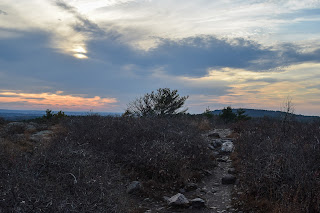
The chipmunks, gray squirrels, and red squirrels were out and about as I wiggled up Buck Hill via the AMC Footpath, entering a burned area at 2182, which was mostly covered in leaves and hard to follow. The views from Buck Hill were, of course, lovely, and it looked like the fire on Wolcott Hill was done smoking (or at least for the most part). I enjoyed seeing numerous planes flying in and out of Logal, and then I was brought right back to reality as I approached MA-28, which is more or less a life-sized go-kart/bumber car course.
Continuing my wiggle, I scooted around a recent blowdown on the Oblique Path and started my long walk back along Old Route 128, where I played some Pokemon Go to pass the time. It was starting to get dark around 5:25, which reminded me how much daylight saving's time was going to hurt.
I made it back to Houghton's Pond, which was very quiet and peaceful, even while surrounded by busy roads. The only other people around were along the shoreline fishing, and soon enough I was back at the car heading home. It was a really nice afternoon hike!
Step-by-Step
- Park at Houghton's Pond parking on Blue Hill River Road.
- Hike to Houghton's Pond yellow-dot loop via unmarked trail.
- Follow yellow dots to the Houghton's Pond Bathhouse.
- Hike towards paved section of Paddock Trail.
- At Bugbee Path, turn left onto Bugbee Path.
- At 2054, turn right onto Skyline Trail.
- At next jct., turn left onto Tucker Hill Path.
- At 2072, turn right onto Ayer Trail.
- At second jct., turn right onto Athol Path.
- At terminus, turn left onto red-dot-blazed path.
- Follow red dots past 2094, then turn left onto Mattapan Path.
- At terminus, turn right onto Skyline Trail.
- At 2117, turn left onto Boyce Hill Trail.
- At 2151, conitnue onto Doe Hollow Path.
- At 2153, continue onto Headquarters Path.
- At 2175, turn right onto Forest Path.
- At 2194, turn right onto AMC Footpath.
- At 2165, turn left onto Skyline Trail.
- At 2181, turn right onto Buck Hill Path.
- At 2183, turn left onto red-dot-blazed path.
- At 2210, turn right onto Skyline Trail.
- Turn right onto Forest Path.
- At 2189, turn left onto Pipe Line.
- At 2176, turn right onto Sullivan Trail.
- At 2163, turn left onto Oblique Path.
- At terminus, turn right onto Old Route 128.
- At paved road circle, turn right to hike along Houghton's Pond, joining with the yellow-dot-blazed loop.
- Near snack shack, hike trails nearer pond.
- Follow paths back to car.


No comments:
Post a Comment