Carter Dome via Carter Dome Trail (White Mountain National Forest)
Hike Type: Out and Back
Distance: 10.33 miles
Elevation: 3,340 feet
Time: 7 hours, 25 minutes (5 hours, 43 minutes moving)
Hiking Challenges: New Hampshire 4000 Footers
The Hike
After a lovely day skiing at Cannon Mountain, Sarah and I drove across the Whites to Jackson. We checked-in to our hotel, the Lodge at Jackson Village, and immedaitely started packing for our adventure tomorrow! The forecast was cold and windy, so we packed basically every article of clothing we owned plus a ton of food and liquids - the usual! Once we were packed up, we walked a few minutes down the road to The Shannon Door - which was a DELIGHT. They had live music (a highlight for us was "The Dunnes Song"), excellent vibes, and the food was reasonably priced - the dream! After dinner we went back to our hotel room, had some cookies we got at the gas station down the road (they were EXCELLENT), watched some Hoarders on the TV, and fell asleep by 9pm.
Our alarms went off at 6am and it was time for the big day! Carter Dome had been a hanging chad on both of our 4000-footer lists for quite some time now, coining the phrase "who hasn't had a Menty B in Carter Notch?!" The first time we planned to hike it was when we did Middle and South Carter, but we ran out of daylight, it was icy, and we weren't sure if all of our bodies were up to it. The second time was when Sarah and I hiked the Wildcats, but once we made it to the Carter Notch Hut her ankle started to really hurt, so we decided against it again. Today, it was time! We got to the Nineteen-Mile Brook Trailhead a little before 7:00am and very slowly got suited up. It was cold and windy on Route 16, so we did a quick car break after suiting up to blast the heat before we started our adventure. The Higher Summits Forecast was daunting, but we remembered that Carter Dome is more sheltered and ~1,500 feet shorter than Mt. Washington. Plus, we both were comfortable communicating our needs to each other if things began to get dicey. We were very aware that this mountain has tested us numerous times, so our mantra became "Thank you, Carter Dome" throughout the day (sometimes geniune, sometimes sarcastic).
Higher Summits Forecast
Updated at 4:08am on Sunday
Sunday: Mostly in clouds with a chance of snow showers early. Then, trending towards in the clear under mostly sunny skies. Possible snow accumulations of a trace to 2 inches.
High: Starting around lower singigts below, then rising to upper single digits.
Wind: NW at 60-80 mph with gusts up to 100mph, decreasing to 35-50 mph.
Wind Chill: 30 below to 40 below early, then rising to 15 below to 25 below.
[7:27am - Nineteen Mile Brook Trail]
At 7:27am, it was time to go! The wind subsided once in the woods, and it was a shockingly comfortable 15 degrees out. There were a bunch of cars at the trailhead, but we assumed most were staying at the hut. Two cars did pull in as we were getting started, maybe we'll see them later? There was a sign at the trailhead that, I'm guessing is in response to the current national government's policies on public lands (i.e., national forests):
In writing: You are just minutes away! Come!
In text: Let's go NH! Nationwide Rally for Public Lands and National Parks; Saturday, 3/22/25, 12-3; Tuckerman Ravine Trailhead. Come join us and of cities across the country to rally for public lands and public parks! We will have craft projects, post cards, and a peaceful rally to support public lands and parks. All are welcome! Bring signs supporting your parks and forests.
Had Sarah and I known, we definitely would have gone! We started our hike with spikes, as the first ~50 feet of the hike were up an ice flow dusted with snow. The first mile of Nineteen-Mile Brook Trail is absolutely delightful, meandering near the brook proper which had some lovely cascades and neat ice formations. I distinctly remembering Sarah talking poorly about this trail when we were planning this hike, which I brought up a bunch, but she vehemently denied it.
[7:38am - Leaves Forest Protection Area]
The trail crossed a small stream on a small bridge and later a large stream on a large bridge, passing a dam on the way up, too. The trail proper was mostly frozen with a few wet spots here and there - spikes were 100% the best form of traction. We were still a bit sleepy so we didn't chat much - plus I kept stopping for photos and to de-layer, while Sarah took longer to warm up (as in, I am a sweaty beast in all temperatures and her body's internal regulation is normal). We stopped at some point to both shed a layer (she was down to just one puffy and I was down to just my base layer) and we met two hikers hiking with a dog - it was the dog's birthday! We initially let them go first, but they let us pass because the dog was fixating on us (we LOVED this dog, and thankfully would see this dog a bunch throughout the day). Right at an hour on-the-dot, we arrived at the Carter Dome Trail junction! We were both surprised and delighted at how quickly that first stretch felt.
[8:27am - Carter Dome Trail]
We had a quick snack at the junction, played leap-frog with our friends yet again, and continued on. Our friends were in the lead now as Sarah and I maintained a slow-and-steady pace up the trail. Footing was still good for spikes and the snowpack was minimal. The Carter Dome Trail started by following a brook and eventually entered a confusing area and crossed the brook, which was tricky but not too awful. Something that was unique about the crossing was the built-up slush on most of exposed rocks, which made things a bit more exciting! We both expressed gratitude we were able to cross unscathed, as a foot plunge could be a day-ender in these conditions. There were some small bushes starting to show signs of spring - little leaf buds that closely resembled the "golden snitch" from the Harry Potter universe.
After the first crossing, the trail continued through a flood-damaged area, past some bushes that had budding leaves, and then to another crossing, where we found our friends again! They told us their route across this stream, and more importantly the dog wanted more pets so he tried to run across the river to get them. Sadly, the dog's route was a bit deeper than he wanted, so he had to continue on without any pets (for now). It was my turn to be line leader - I made it most of the way across and then the unthinkable happened. SPLASH. Actually, more like PLOP. My foot slide off of a slushy rock into calf-deep water... NOOOO! I got up and out, furious, and Sarah was standing in the middle of the stream, balanced on two rocks, in absolute shock and dismay - we had JUST said a sunken foot could be a day ended. I told her to get to my side of the river so we could figure something out, because I was NOT going to let this mountain win again (unless I was in actual danger of course). After some brain storming, I changed my sock to a thick, dry one, dumped my peanut butter-filled tortillas into my pack, shoved my foot into the gallon-sized ziploc they were in, and shoved everything back into my boot. I wasn't sure how well this would or wouldn't work, but it was worth a shot! Since we were doing an out-and-back, I decided to leave my soiled sock on a branch at the crossing to grab later.


I tightened my wet boot, and we were back in business! The next stretch of trail followed a series of seven switchbacks (according to the guidebook, neither of us had the brain power to actually count) all the way to Zeta Pass. Footing was mostly good here and grades were moderate and steady. I was trailing behind as I adjusted my boot (and broke up some ice on the bottom of my pant leg). We got occasional tree-views toward Boot Spur and Mt. Washington, which looked incredibly commanding even though these trees. Once higher up, the wind became more noticable and temperatures began to drop. I made a loud "UGH" at one point, as I was done with the slog, and we arrived at Zeta Pass no more than 30 seconds later!
[10:05am - Zeta Pass]
We did a quick snack, hydrate, and pee break at Zeta Pass. My Nalgene was slushy at this point, so I drank as much liquid as I could and then swapped it for one that was in my pack and CHUGGED. My peanut butter roll-ups were perfect, and I put my fleece and nano puff back on as I paced back and forth. It was cold! I finished up a little before Sarah, so I began to walk up and down the trail to keep warm. It was significantly snowier up here, which was beautiful! The sun was shining through the trees, too.
We climbed through a snowy area and then started the slog to the ridge, soon passing the Carter-Moriah Split that went up to Mt. Hight, which did not look very traveled (plus we knew it was a much steeper and more exposed route).
[10:28am - Carter Dome Trail/Carter-Moriah Trail Split]
We continued climbing on a long stretch of side-hill. Thankfully, the snowpack was firm and trees were mostly above our heads (we did have to push through a good amount, since we were hiking on feet of snow.
[10:32am - Leaves Forest Protection Area]
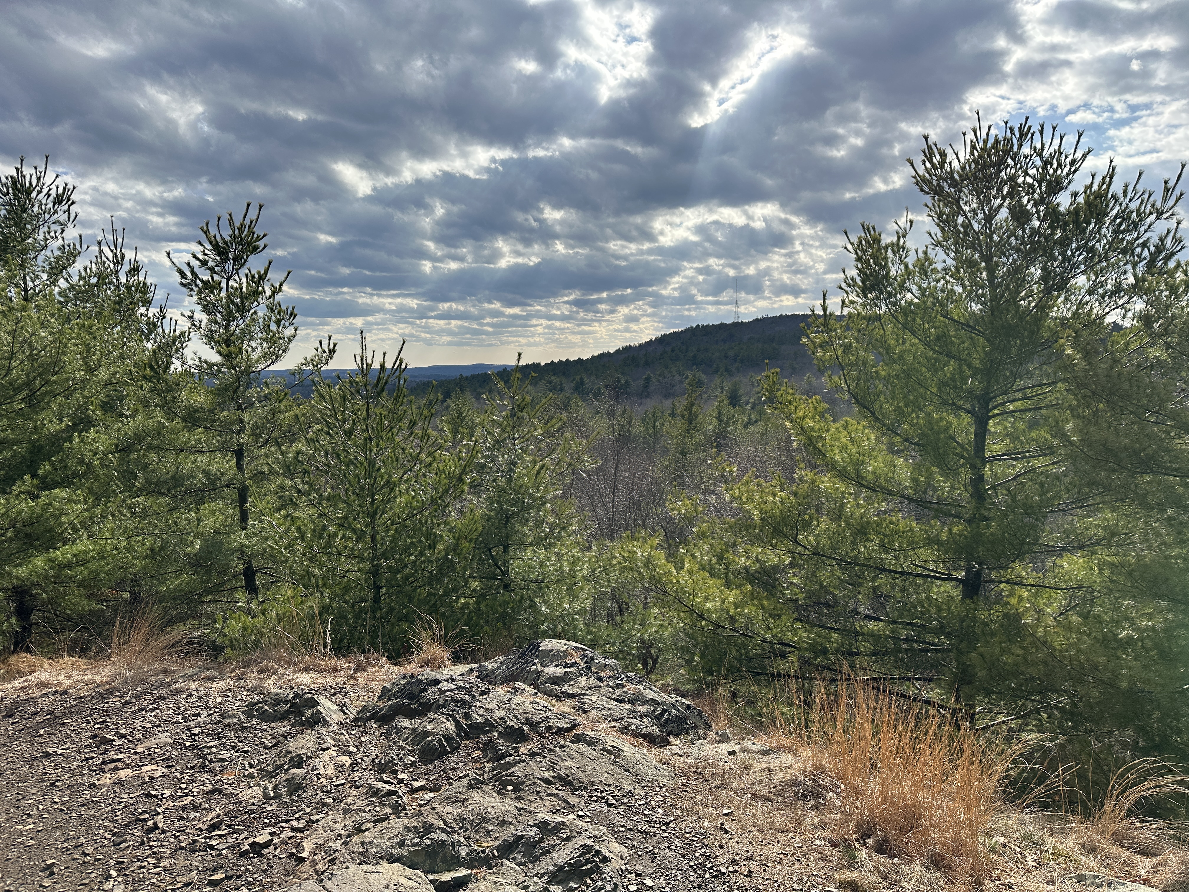
Higher up, we began to get peek-a-views toward the Presidentials, which just looked incredible. We could see the snow being blown around on the summits as we were dealing with some wind now. I joked that at least on the way down we'll get to even out our frostbite! We continued through this small tree tunnel, occasionally singing exceprts from "The Dunnes Song" that we heard last night at the Shannon Door. My soggy foot was a little cold, but nothing colder than I had experienced skiing, so I felt comfortable continuing on.
[10:55am - Carter Dome Trail/Carter-Moriah Trail Coincide]
Things started to turn around once we hit the other end of the Carter-Moriah Trail. The tree views were increasing, our bodies had warmed up, my foot was back to feeling fine (NOT numb, to be clear), and we were starting to get excited since we were now up on the ridge.
[10:57am - Carter Dome Trail/Black Angel Trail Junction]
Just a few feet later we came up to the Black Angel Trail junction - the trail sign was burried right up to the top! We had tree views out over the Wild River Wilderness side of the mountain now, and two Grey Jays joined us! Unfortunately, my camera battery got too cold here, so I didn't get photos on my camera of these adorable, fesity birds, but we enjoyed their company as we put on our shells for the final push to the summit.
The way that this climb went from a boring slog to an incredible adventure could be studied. Soon after the Black Angel Trail junction, the Carter Dome Trail climbed up a snowbank to reveal some absolutely amazing views. First we could see the northern stretch of the Carter-Moriah Range, with Mt. Hight nearby and South and Middle Carters further along, but then we turned and saw the Northern Presidentails standing tall and proud. We throught we'd get some views with the high snowback, but NOTHING like this! The wind was howling, but our layers were doing their jobs. I couldn't help but take endless photos of how incredible the view was. To make things even better, we crossed paths with our friends again! They asked us if we were familiar with this trail in the summer. We told them we hadn't been, but we'd heard it was boring and viewless, and they confirmed. They said we came up on an incredible day, which was super validating to hear. We pet the dog some more and parted ways - they were planning to head to Mt. Hight, which was on mine and Sarah's radar, but with this wind we weren't sure (plus, we were THRILLED with the views we had here!).
[11:23am - Carter Dome Summit]
One final push brought us to the summit clearing, and when I tell you I RAN to the summit sign/Rainbow Trail jct. sign... THIS was cause for a celebration! To make things even better, the summit clearing was full of sunshine and super sheltered from the wind. We originally planned to have our celebration snack at Zeta Pass on the way down, but it was so comfortable up top we decided to celebrate at the top!
Before food we explored a bit. A few feet down the Carter-Moriah Trail towards Carter Notch was a nice view of Mt. Carrigain over the trees, and on the northern side of the summit clearing was an opening that provided an excellent view of Mt. Hight, South Carter, Middle Carter, Mt. Moriah, and Shelburne Moriah, with countless other mountains in the background. To the left was Mt. Washington, Mt. Jefferson, Mt. Adams, and of course, Mr. Madison. It was windy at this view, though. I measured the ambient temperature at 5 degrees, windchill around -22, and winds 25 to 30 mph.

Now, it was time for our reward! A couple of Grey Jays popped out of the woods, posing for hundreds of photos (and also nagging us for a snack). Sarah and I plopped down and got to work (to feed us, not the birds). Sarah prepared a charcuterie moment with cheddar cheese, Babybelle cheese, pita chips, and pepperoni, while I got out my JetBoil and made us some hot chocolate (with RumChata for me!). It wasn't until we were sitting for close to 20 minutes that we started to get chilly and wrap up this party. Summiting this mountain has been one of my favorite accomplishments I think. It had just been looming over us for so long, and it felt like such a priveledge to finally conquer it (after plunging my foot into a brook) on such a beautiful day with such amazing views while playing leap frog with some nice hikers and their dog AND with Grey Jays (even if they were getting a little fesity while we were eating). Such a good day!!!! (Edit from the future: as I was editing my photos, I wanted to come back and write again just how amazing, adorable, friendly, and feisty these birds were! They were excellent photo subjects).
[12:00pm - Carter Dome Trail]
Sadly, it was soon time for us to head down. We had flirted briefly with braving the steeps and going down to the hut, but decided to stick to the devil we knew (and I also had to collect my frozen sock at the brook crossing). We took our time on the stunning ridge walk, enjoying views north and into Maine, but we couldn't stay for too long because the winds had picked up! I measured 25 to 30 mph at the view from the summit, and I'd estimate these gusts were 5-10 mph faster than before (almost knocking us over). My joke about evening out our frostbite rang true, becasue now the other half of my face was NUMB (no actual frostbite, though). Conditions started to improve once we hit the Black Angel Trail and the Carter-Moriah split to Mt. Hight - our friends did head out that way, but the wind we just tasted dissuaded us from any side-quests. We continued down along the side-sloping hard pack. I tend to move faster on the descents, so I'd get ahead at times, and we only really paused to share whatever dumb thought that popped into our heads (or to share a lyric from "The Dunnes Song").
To our absolute delight, we ran back into our friends where the Carter-Moriah Trail rejoined the Carter Dome Trail! We reached the point of leap frog where we just laughed whenever we saw each other. They said the view was spectacular but the winds were brutal, especially on the descent, which definitely validated our decision to skip it.
I didn't note any time stamps from the summit to Nineteen Mile Brook Trail for no other reason than I forgot to, oops! We were down in Zeta Pass not much longer after the junction, and we stopped for a quick sip, snack, and pee. Our friends caught up to us again, we giggled, and kept on heading down!
The descent felt MUCH quicker than the ascent, which made sense, and the tree views to the Presidentials were still amazing, even if they were mostly obscured. After the series of seven switchbacks, we made it to the dreaded brook! I claimed my sock, which was frozen solid, and we both crossed much more successfully. It was interesting, though, becuase water levels had slightly risen and there was a LOT more slush present in the water. The confusing stretch was still wonky, and we survived the bigger crossing by moving slow and steady (thank goodness for poles).
From the crossing to Nineteen Mile Brook Trail, the Carter Dome Trail's snow and ice cover had melted significantly in the sunlight. We were hiking on a lot more exposed ground now. Thankfully, it was soft, but not dreadfully muddy. We continued down alongside the cascading, roading brook, and eventually saw our trail sign! Victory!
[1:52pm - Nineteen-Mile Brook Trail]
We took one final break here, said another hello to our friends as they caught up to us, and then blasted off back to the trailhead. The Nineteen Mile Brook Trail was now mostly sunlit as it meandered along the brook. It was a little rocky near the Carter Dome Trail but slowly became more and more lovely. In a final act of defiance from the mountain, my hiking pole got caught between my legs while I was walking, and I guess the lower section was fully extended, so my legs crossing each other over the pole caused it to snap. UGH.
Sarah and I were feeling good, but definitely tired after the festivities of the day! The snowpack was disappearing quickly down here, and some of the "glaciers" we struggled up in the morning were significantly softer and had great grip with spikes. We knew we were getting closer when we passed the dam and the large bridge.
[2:38pm - Enters Forest Protection Area]
The trail eventually entered a denser, tall forest down low as it entered the Forest Protection Area - almost there! We could soon hear the rush of cars on NH-16 (a sobering sound after a day where all we could hear was water and wind), and then before we knew it we were descending the final slushy glaciers to the parking area! We did it! #45 complete!
[2:45pm - End of Hike]
We had originally planned to enjoy some sparkling wine once at the car, but it was still cold and windy, so we'd save that for another day. We slowly got changed into our comfy clothes (notably our new Cannon Mountain merch becasue we're both suckers for a gift shop) and worked our way to the Moat Mountain Brewing Smokehouse and Brewing Company in North Conway where we had some DELICIOUS macaroni and cheese to celebrate knocking this mountain off of our list!
The drive home was long, but we did it in full daylight and company always makes the drive feel faster. There's been online discussion about being an "uphill person" or a "downhill person," which Sarah and I have talked about a few times, since we both love skiing and hiking. While we both love the downhill, there's no better feeling than conquering a big climb. Sure, we feel the endorphins and adrenaline when we're on sticks flying down a mountain, but the high from sitting at a summit is so much greater for us. This was such a surprisingly awesome day!
Step-by-Step
- Park at Nineteen-Mile Brook Trailhead.
- Start hike on Nineteen-Mile Brook Trail.
- At jct., turn left onto Carter Dome Trail.
- At Zeta Pass, continue on Carter Dome Trail.
- Summit Carter Dome, retrace steps to car.
“Nineteen-Mile Brook Trail” from White Mountain Guide, 31st Ed. (2022)
NH 16 to Carter Dome Trail: 1.9 mi; 850 ft; 1:25
AMC This blue-blazed trail runs from a parking area (plowed in winter) on the east side of NH 16, 1.0 mi. north of Mt. Washington Auto Rd. and 2.4 mi. south of the jct. with Pinkham B Rd. (Dolly Copp Rd.), to Carter Notch Hut and is the easiest route to the hut. (The parking area is a stop for the AMC Hiker Shuttle.) Sections of the trail near the brook bank sometimes become dangerously icy in cold seasons.
Leaving NH 16, Nineteen-Mile Brook Trail enters the woods to the left of a kiosk on a relocated section and then rejoins the original route at 0.1 mi., following the northeast bank of Nineteen-Mile Brook on the remains of an old road at easy to moderate grades. At 0.7 mi. the trail crosses an open bank above the brook and soon turns left up rock steps on another relocation, returning to the old route at 0.9 mi. At 1.1 mi. it crosses a major tributary on a large bridge just downstream from the former crossing.
At 1.2 mi., the trail passes a dam in the brook and becomes somewhat rougher, with minor ups and downs, and at 1.9 mi., Carter Dome Trail diverges left for Zeta Pass. [...].
“Carter Dome Trail” from White Mountain Guide, 31st Ed. (2022)
19-Mile Brook Trail to Zeta Pass: 1.9 mi; 1,550 ft; 1:45
Zeta Pass to Carter Dome Summit: 1.2 mi; 960 ft; 1:05
WMNF This blue-blazed trail runs from Nineteen-Mile Brook Trail 1.0 mi. from NH 16 to Zeta Pass and the summit of Carter Dome, following the route of an old road that served the long-dismantled fire tower that once stood on Carter Dome. Grades are steady and moderate all the way.
Leaving Nineteen-Mile Brook Trail, Carter Dome Trail follows a tributary brook, crossing two branches of it at 0.5 mi. and recrossing it at 0.8 mi., at a small, attractive cascade; in this area, parts of the trail were damaged by Tropical Storm Irene in 2011. Carter Dome Trail swings left and then in 50 yd. turns sharply right and ascends by a series of seven switchbacks, passing a good spring on the left at 1.1 mi., and reaching the jct. with Carter-Moriah Trail at Zeta Pass at 1.9 mi. Carter Dome Trail coincides with Carter-Moriah Trail to the right (south). At 2.1 mi., Carter-Moriah Trail, which offers excellent views but is steep and exposed to weather, turns left to climb to the bare summit of Mt. Hight; Carter Dome Trail continues its steady, sheltered ascent along the west slope of Mt. Hight. At 2.7 mi., Carter-Moriah Trail reenters from the left, and in another 25 yd., Black Angel Trail enters from the left. Carter Dome and Carter-Moriah trails now coincide, ascending through high scrub, passing a side path leading 10 yd. right to a viewpoint at 3.0 mi., and continuing to the jct. with Rainbow Trail near the southwest end of the Carter Dome summit clearing.