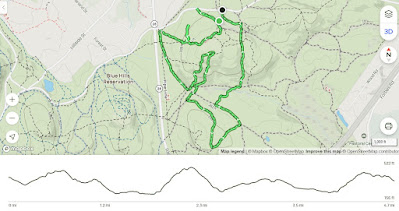
Chickatawbut Hill; Sassaman, Glover, Lee, & Slide Notch Paths (Blue Hills Reservation)
Hike Type: Loop w/ Spurs
Distance: 4.66 miles
Elevation: 873 feet
Time: 1 hour, 48 minutes
Hiking Challenges: 52 Hike Challenge 2025; Trail Trace the Blue Hills
Hiking Challenges: 52 Hike Challenge 2025; Trail Trace the Blue Hills
The Hike
First hike of April! I wanted to get out yesterday, but as April Fools would have it, there was absolutely brutal traffic. I made it to the Chickatawbut Tower trailhead and got hiking around 4:10pm, just aiming to do some tracing around the Chickatawbut area. It had been another draining week, so I was excited to get out and blow off some steam! It was a cold 44 degrees with a breeze and overcast and my legs were TIRED from my first leg day in a few weeks. My internal soundtrack for most of the hike was "Chitty Chitty Bang Bang," but with the lyrics "Chick-a-taw--but, Chick-a-chick-a-taw--but" - classic.
I forgot to turn on my watch until the tower, which was annoying but literally fine. Sassaman Notch Path was in good shape and the eastern branch of Thayer Path was steep and leafy, but short. I made my way across the road to the closed summit and noticed someone found a pair of old sunglasses that seemed to have been through a war - the finder hung them up on a fence.
I continued down to the water tower, hiked on the gravel road (which had new gravel on the half closest to the tower!), and then continued down to the Braintree Pass Path trailhead. There were lots of frog eggs in the little swamp there! It did look like they might dry out, but rain was coming to hopefully help. I saw my first person of the day later on on the Braintree Pass Path, and realized my slightly slower-than-usual hiking pace was the same tempo as "Children's March" by Percy Grainger, so I had a new song in my head!
I scrambled up the Skyline Trail to the first view off Chickatawbut, and then scrambled again up to the second view. The third climb is the easiest of the three, which led to the fence around the summit area. My hamstrings were FEELING IT. On a clear day with better lighting, the view to Buck Hill would actually be really cool, especially with people on top.
I continued around the fence briefly and then descended on Carve Path and made my way over to Glover, which is a favorite of mine. Quiet, open woods, and old stone walls. Lovely! Actually, most of the "deeper" paths in this area are just wonderful. The clouds were getting darker and the breeze was picking up, which gave me some post-traumatic stress from the last time I was over near Hawk Hill and it started to rain, but thankfully I was safe (minus someone's dog's massive poop they left in the middle of the trail).
I wiggled around to Lee Path, which was a little wet in spots, and then climbed back up Slide Notch. I had grand plans to add Squamaug Notch to the hike, but I was TIRED. I found a couple of deer in the burnt area on the left of the trail, and then continued back to the Tower Path. I ran into a hiker coming down the footpath from Nahanton. He asked me how to get back to the parking area. I pointed to the Tower Path and he said "well I'm going this way, I'm not f***ing walking that again" and took off towards the road. I don't think this stretch was all that bad, but to each their own!
He and I made it to the parking area at the same time, and just a few minutes after someone had blown a tire driving through, which made for some interesting traffic. Thankfully, I was up and out of there in no time, and soon on my couch eating dinner!
Step-by-Step
- Park at Chickatawbut Tower parking.
- Start hike on Tower Path.
- Turn right at Tower to continue on Tower Path.
- At 3075, turn right onto Sassaman Notch Path.
- At Chickatawbut Road, turn around.
- At 3075, continue right onto Sassaman Notch Path.
- At second jct., turn right onto east branch of Thayer Path.
- At jct., continue left/straight on Thayer Path.
- At jct., continue right/straight on Thayer Path.
- Cross road, continue on Thayer Path.
- Hike gravel road from water tower, then descend via unnamed path along power cut.
- At terminus, turn left onto Headquarters Path.
- At 3024, turn left onto Braintree Pass Path.
- At jct. after 3042, turn left onto Bouncing Brook Path.
- At jct., continue onto Skyline Trail.
- At 3065, turn right onto Carve Path.
- At 3051, turn left onto Bouncing Brook Path.
- At next jct., turn right onto unnamed path.
- At terminus, continue onto Slide Hill Trail.
- At 3040, turn left onto Glover Path.
- At 3044, turn left onto Hawk Hill Path.
- At 3072, turn left onto Braintree Pass Path.
- At 3155, turn right onto Lee Path.
- At terminus, turn right onto Bouncing Brook Path.
- At 3073, turn left onto Slide Notch Path.
- At first left after 3094, turn left onto Tower Path.
- Follow Tower Path back to car.


No comments:
Post a Comment