Sunday, February 18, 2024

Skiing Black Mountain of Maine

We had a nice siesta featuring hotel waffles (my favorite vacation delicacy) after our hike of Rumford White Cap and then took the long, grueling, 10 minute drive to Black Mountain of Maine! The parking area was quite full so we landed in the frozen-rutted overflow lot (I’m sounding dramatic, it was fine). We redeemed our Indy Passes with no problem. In honor of our personal ski instructor Emma, we arrived around lunch time, and the lodge was FULL. We landed booting up outside, which truly was fine - it was now in the upper 20s, which basically felt like summer after our morning! 

Mountain Report
February 18, 2024 6:00am
Elvis might have left the building but the weekend fun rolls on! Your corduroy carpet is waiting & tickets are just $55! We're skiing & riding on 29 trails with packed powder & variable conditions. Temperatures are forecasted to be in the mid 20's with partly sunny skies. Note: ungroomed trails have some accumulated snow on top of a firm layer of crust.
        The Lower Allagash is open once again after great efforts by our snowmakers. School break is on! Look for extended hours & a Winter Carnival like never before. Hit the slopes all week from 9am-4pm for just $55 or hit the tubing park from 12pm-4pm for $20! Catch live music, outdoor games plus free sleigh ridges. It's a week jam packed with unforgettable fun. Plus, a full day of free winter fun from 9am-9pm on Feb 22nd sponsored by L.L.Bean.! Let's make this school break one for the books.

Once we were suited up we headed over to the Novice Lift, an old, adorable double, where we would do somewhere around 10 laps over the course of a couple hours. We started with just following Ellis (the run under the lift), then we went a bit wider on Lower Sunday, then Magalloway (which became our “fun run” since we could/needed to get some speed), then Aroostook and The Bean too. We really hit all these runs in all the different permutations. Eventually, we landed in a groove of “skill runs” and “fun runs.” Skill runs involved practicing our parallel turns, specifically using our knees/fronts of our feets (apparently I’ve been heel-reliant). The fun runs were usually over on Magalloway and were geared for no-brain just ski, which was lovely. We did this for just under two hours before we got hungry. I had the itch to go higher up the mountain, but Gen made a good point that tomorrow will be another big day at Saddleback, and then we can come back to Black on Tuesday for our final runs.

Note: there were at least two additional runs before my watch started tracking, one on Ellis, one one Aldro-Ellis.
Run 1: Lower Sunday - The Bean
0.23 miles, 1:52, 1745 feet, 16.6 mph max, 7.2 mph avg.

Run 2: Androscoggin - Ellis
0.19 miles, 1:47, 180 feet, 18.4 mph max, 6.4 mph avg.

Run 3: Androscoggin - Ellis
0.24 miles, 2:29, 164 feet, 16.9 mph max, 5.7 mph avg.

Run 4: Lower Sunday - The Bean
0.29 miles, 2:48, 171 feet, 16.9 mph max, 6.3 mph avg.

Run 5: Magalloway (Uphill Entrance)
0.28 miles, 1:11, 177 feet, 25.2 mph max, 14.1 mph avg.

Run 6: Androscoggin - Ellis
0.29 miles, 3:25, 174 feet, 12.7 mph max, 5.0 mph avg.

Run 7: Magalloway (Uphill Entrance)
0.25 miles, 1:24, 171 feet, 25.6 mph max, 10.9 mph avg.

Run 8: Lower Sunday - The Bean
0.19 miles, 1:27, 174 feet, 17.3 mph max, 7.8 mph avg.

Run 9: Magalloway (Downhill Entrance)
0.27 miles, 1:17, 194 feet, 25.6 mph max, 12.5 mph avg.

Our goals for Saddleback are to apply our skill runs to the longer greens that they have there, I want to conquer the steep section on Hudson Highway, and we want to hit some of the easier blues, which involve taking the Rangeley Quad to The Pass, which will be a whole adventure. I’m excited! For Black, we’re going to hit the green “glades” and the novice “park” as a bit, and then want to get up to the top of that mountain, too. Lots of goals over the next couple of days!

Our day ended with getting the last two stools up at the Last Run Pub where there was a lovely duo playing live music. We didn’t realize they didn’t have food at the pub, so instead of eating cafeteria-style food we just had mac and cheese bites at the mountain and then got McDonalds/ate our leftovers for dinner, followed by a long siesta/early bedtime.

Rumford Whitecap Mountain (Rumford Whitecap Mountain Preserve)

Rumford Whitecap Mountain (Mahoosuc Land Trust)

Distance: 5.11 miles
Elevation: 1,578 feet
Time: 2 hours, 52 minutes 
Hike Type: Out-and-Back
Hiking Challenges: Operation Alaska Benchmark Challenge

The Hike
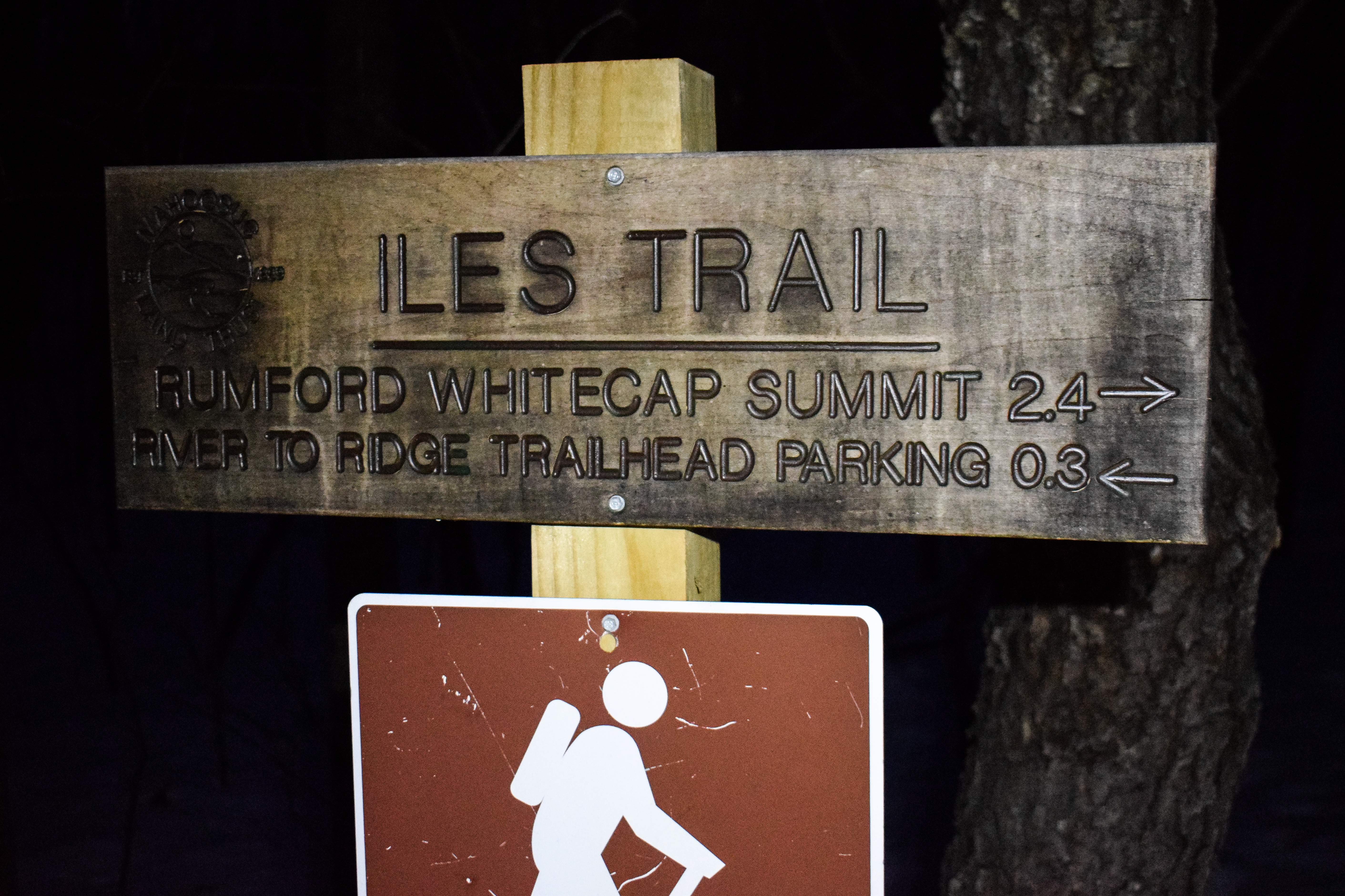
Day two of vacation! Our plans for today were to hike Rumford Whitecap Mountain and then head over to Black Mountain of Maine for some more skiing. We thought about doing a true sunrise hike, but due to forecasted colds and partial to full cloudiness, we opted for a “start in the dark and hike while the sun is rising” hike. Our alarms went aggressively off at 5:00am, we slowly got our stuff together, we met the lovely “grandma” who was getting breakfast ready (and insisted we take a muffin with us, and made sure that someone knew where we were going so we were safe), and did the short 15-minute drive over to the trailhead. The trailhead had room for 6-8 cars if they parked well, and miraculously had a porta potty! I was particularly nervous about having to use the bathroom, since the urge usually hits while I am driving to the mountains. I did a short, COLD christening of the toilet, and we got going!


Trailhead temperature was a solid 1 degree, but thankfully the air was still. We crossed the road, put spikes on, and we were off! The trail conditions were good here, with a few post holes off to the sides, but nothing too gnarly. The trail followed what felt like a logging/woods/atv road for the first bit, and then the trail branched off after a backcountry skiing map. From here, the trail climbed at easy to moderate grades, which thankfully would persist the whole time.


We varied through hardwood and coniferous forests, and really enjoyed watching the first light hit the surrounding mountains through the trees. In warmer months there would be a good number of stream crossings, all of which were frozen over here. Our first mile was slow due to figuring out our layers - it was cold! We both had frozen hair and eyelashes, and my poor buff was rock solid.


Further up we entered “zone 2” - the partially open slabs. There were great views toward the skies, but no views out in this area. The trail was still well-packed, but there were some dicier post holes around. We passed two people who were up top for the actual sunrise, so we figured we did the right thing as humanitarians by waiting the extra hour so they could have the summit to themselves. We also passed the junction to Black Mountain up here, and we joked that if only we brought our skis we could go!


The trail continued over some snow-covered bog bridges and eventually hit the third and final one - open slabs - the “white cap.” The trail was more difficult to follow up here since there were lots of ski tracks and any snowshoe tracks had been blown over. Generally, the crust was firm so we didn’t have a problem sans a few spots, but I would recommend snowshoes for this area. With every step the views increased in all directions - really spectacular.


The sun was shining through the thin clouds as we approached the summit, and we found a benchmark summit marker! Such a fun surprise. There were views toward Old Speck, the Royces (which I’ve seen from the Baldfaces), two other small ski areas, the town of Rumford and Rumford Mill, Black Mountain, and many, MANY others. We planned to stay up here for a bit, but it was COLD COLD. With a slight breeze, -9 degrees. We took some photos, bundled up, and started our return. We now understood why the two people who passed us earlier were VERY bundled.


The return in zone three was just beautiful, and zone two was easy going. We passed two uphill hikers during this time. Overall, the descent was quick and easy, but we had to be more cognizant of the portholes - my ankles did get caught a couple of times. Soon enough we were back in zone one, and even sooner back at the car!


We did a quick change and drove back to the Circle K next to our hotel for caffeine, saw grandma again while we got our hotel waffles, and got ready to head over for skiing day two!

EDIT FROM FUTURE ME: I forgot to mention we passed someone heading up the mountain as we were descending. We pulled over, she said “thank you, enjoy your hike down,” and before I processed that last word I said “you too!” Horrible. Anyway, turns out it was local hiking celebrity, Ilse Dunbar!

Step-By-Step
- Follow Orange/Red (Iles) Trail from parking lot to summit and back!


Trail Descriptions
"Rumford Whitecap Mountain Preserve" from Parking Kiosk
The Rumford Whitecap Mountain Preserve is a 761 acre undeveloped tract of land that includes part of the summit and the south slope of Rumford Whitecap Mountain (elev. 2214'). The preserve includes 132 acres of bald summit with open ledges providing outstanding 360 degree views.
        The land within the preserve was purchased by Mahoosuc Land Trust in 2007. It was aquired through teh generosity of over 500 donos as well as grants from the Lands for Maine's Future board and five charitable foundations. Mahoosuc Land Trust is proud of its work to protect this mountain.
        The summit of the mountain is accessible by two trails, the Orange/Red marked trail starting directly across the road from this kiosk, or the Starr trail, marked with yellow flags and blazes, starting at the grey gate 150 yards farther north along the road. The trails merge about 2 miles up the mountain and continue another half mile to the summit.

"Rumford Whitecap Mtn. (2,214 FT.)" from Maine Mountain Guide, 11th Ed. (2018)
The 752-acre Rumford Whitecap Mtn. Preserve in Rumford is the signature conservation property of the Mahoosuc Land Trust. The preserve includes the bald summit ridge and south slopes of Rumford Whitecap Mtn., which offers panoramic views and plenty of blueberries in season. Two maintained trails ascend the mountain from the southwest. 
        From the jct. of US 2 and ME 5, 0.5 mi. west of Rumford Point, go north on ME 5 toward Andover. At 2.8 mi., turn right (east) and cross the Ellis River. At 3.2 mi., turn left onto East Andover Rd. and, in another 0.2 mi., reach the trailhead parking area on the left. Red/Orange Trail begins at a red gate directly across the road. Starr Trail begins about 100 yd. north on East Andover Rd. at a gray gate.

"Red/Orange Trail" from Maine Mountain Guide, 11th Ed. (2018)
From the gate (red/orange markers), follow the woods road and soon reach a register box on the right. Pass throug a log yard and bear left. Climb gradually to reach a trail jct. on the left at 0.3 mi. This trail (green markers) leads northwest about 0.1 mi. to cross a stream on a bridge before joining the Starr Trail.
        Beyond the jct., Red/Orange Trail continue to follow the woods raod, climbing moderately. Ahead, the road narrows in a level area and bears left (sign: to foot trail). Climb steeply on switchbacks and rock steps, contour to the east for a short distance, and then resume climbing. Cross a semi-open area, then cross a wide track (the old trail route to the summit, more direct but steep and eroded). Ahead, follow cairns over ledges to finally merge with the old trail route. Turn right on the wide, eroded trail and climb easily ot the jct. with Black and White Trail on the right at 1.5 mi. (leads 4.8 mi. to the summit of Black Mtn. and then to the base lodge of the Black Mtn. ski area), and with Starr Trail (yellow markers) on the left at 1.8 mi. Continuing ahead on Red/Orange Trail, climb gradually up the ridgeline through semi-open terrain to reach the ledges of the open summit at 2.5 mi. The 360-degree view is spectacular and includes Black Mtn. to the east, the high peaks of the Mahoosuc Range to the west, the White Mountains of New Hampshire farther west and to the south, Mt. Zircon and many other summits of the Oxford Hills. (Note: a portion of teh Rumford Whitecap summit is privately owned. Please stay on the trail and practice Leave no Trace.)


Saturday, February 17, 2024

Skiing Saddleback Mountain

Indy Pass ski vacation is in action! Gen and I arrived to Rumford Friday night, home of Back Mountain of Maine, and woke up early to make the additional hour drive to Rangeley for our first day of skiing in Saddleback Mountain! We arrived at the lodge around 8:15am, just before lifts opened, easily redeemed our passes, slowly got set up, and took it all in! We were excited and nervous for the day to come, especially since it was Gen's first ski day of the season. The atmosphere of the lodge was lovely, cozy, and friendly, and the staff were truly delightful. Our day would consist of 9 runs in 18-degree weather, almost no wind, and constant snowglobe snow!

Mountain Report
Saturday, February 17th @ 7:05am
        "First tracks on groomed trails this morning will be amazing" - Jared. you heard it here first. Come and get it while it's hot. All of our lifts are expected to start spinning at 8:30am, allowing you to lap Maine's Favorite Mountain. The clouds dropped off another 2 inches of snow within the past 24 hours, refreshing the surface oh so nice. Even though it was windy, conditions were great yesterday, and I couldn't contains the "yewwwws!" coming out of my mouth. I expect some of the same, if not better, today.
        Temperatures in the low 20s will be present at teh base area, while the summit will range from 10-12 degrees Fahrenheit. Throw in some overcast skies and a breeze, and that's the weather for today. 
        Did you know that we as a mountain and a community are back to back champs?! Gather 'round the base area today, Saturday, February 17th, at noon, and join us for a special surprise enveiling! What could it possibly be? I don't know, you'll have to come find out!
        Throughout the week, lifts will continue to open to the public at 8:30am, giving y'all some extra time on the slopes. Take advantage of it!
        The SBTP crew worked late the other night to bring you some fresh features in Wheeler Park. It's an all-you-can-hit buffet with some new additions: a down tube, flat double barrel, flat box, and a flat down flat bar. Plus, the 13' half pipe on Montreal is open. This is Maine's only Zaugg cut and maintained half pipe. Rip it up!

Saturday, February 17th @ 1:23pm
        Whoever shook the snow globe at Saddleback, we love you! Flakes have been floating down from above all day, blanketing our trails in that white gold. Keep it comin' Mother Nature! Conditions on the groomed trails were top tier today. Natural terrain is starting to get deeper, but beware of the hidden hard pack underneath. it's been a rockin' start to President's week, and we are stoked to have you here for the unique Saddleback experience.

Run 1: Lodge to South Branch Quad via Royal Tiger
[0.50 miles, 3:19, 341 feet, 17.6 mph max, 9.0 mph avg]
Something I read about Saddleback was that the beginner area is FANTASTIC since it is below the lodge area (therefore, no speeding bullet skiers flying past you), and I agree! Our day started with a run right away heading down the Royal Tiger to the base of the South Branch Quad. Every time I take my first run it feels like I’ve never skied before, but slowly it became more comfortable. My specific goals for this trip are to work on my edge turns and keeping my shoulders facing forward the whole time.

Run 2: Dusty Miller to Hummer to Royal Tiger
[0.61 miles, 3:22, 367 feet, 18.8 mph max, 10.8 mph avg]
We were excited that the whole area here was filled with green trails, so for run #2 we decided to hang right to Dusty Miller. This was also our first lift ride of the day, and our first encounter with our new favorite lifty - an old guy with a handlebar mustache who would aggressively wave at us and was wearing different, insane hat. We saw a top hat, Native American headdress (yikes), and a flamingo. Royal Tiger was filled with day-one beginners, and there was NO ONE back here! The trails were groomed, but the snow globe-snow had the tops super soft, and there were minimal tracks at this point of the morning. It was fun to experience not-first-tracks-but-still-early-tracks. It was also a very different experience going through a couple inches of powder, even on this easy run. I turned onto Hummer on a whim, and sadly slowed down a little too much at the end before Royal Tiger, so I had to ski-skate up to Royal Tiger for the final descent.

Run 3: Dusty Miller
[0.60 miles, 2:41, 358 feet, 21.2 mph max, 13.4 mph avg]
At this point, we were noticing how slow this lift was. We sat with a nice girl who’s been skiing here since she was 3 (and she truly could have been anywhere from 13-21 years old, who knows), and when the lift kept stopping we had nice chit-chat. The terrain here was excellent, but man, the lift was slow. This time, we took Dusty Miller all the way down, and it was just a lovely run. The trails were getting a little more busy at this point, but still nothing bad at all.

Run 4: Royal Tiger to Smelt Streamer
[0.60 miles, 3:53, 367 feet, 19.8 mph max, 9.3 mph avg]
Our next goal was to hit the other side of this area. We were aiming for Hornberg, but missed the entrance and hit Smelt Streamer instead. This was a nice trail with a little more variation than the others. We were extra careful to not hit the terrain park, and succeeded!

Run 5: Royal Tiger to Hornberg to Smelt Streamer
[0.63 miles, 4:12, 367 feet, 20.7 mph max, 9.0 mph avg]
More successful this time! The sign for Hornberg was tucked away. Gen didn’t trust it when we flattened out around a bunch of Condos, but I was pretty sure it continued on. I continued past through deeper snow, over a bridge (SCARY!), and then bottomed out and had to ski-skate up a small incline. From here, there were no signs, but there was a nice man watching his child lay in the snow. I asked him if I was horribly lost, and he said no and simply pointed down a short steep where the trail continued, and then linked back with the Smelt Streamer. I eventually met Gen at the end, and on we went!

Run 6: Dusty Miller to Hummer to Royal Tiger
[0.61 miles, 2:40, 364 feet, 19.8 mph max, 13.6 mph avg]
Our last lap in this area for now! We wanted one more nice easy run before we took a warming break (neither of us could feel our toes), so we went back to the other side to cruise down. I planned to do Dusty Miller all the way again, but I found the ski school on the lower part of that trail, so I switched over to the Hummer again. At this point, I feel I was getting better at aiming my shoulders at one place, and was continuing to practicing using my edges by engaging my knees.

BREAK
We took a lovely break by the large fireplace in the lodge to warm up and drink some gatorade.

Run 7: Hudson Highway
[1.82 miles, 13:55, 1,273 feet, 22.8 mph max, 7.9 mph avg]
It’s time! We scootched over from the lodge to the Rangely High-Speed Quad, sat with two others (who seemed to have a similar relationship as me and Emma, one expert and one apprentice), and made our way up! I loved this ride. The snow globe was in full effect, and as we got higher up the trees became more encrusted with snow. The unloading area was VERY flat, which was a solid bummer, but c’est la vie. The guy on the lift mentioned that the Hudson Highway does have some rough flat section, but we decided to fully experience it at least once, even if it’ll suck. From the top, the trail was BUSY. In hindsight, we should have waited. Oh well! The upper part was fast, and that led into a tricky head wall. I was moving too fast, I was stressed, and there were people EVERYWHERE, so naturally, I fell. I definitely struggle with head walls. Maybe I’m fighting it too much? Not sure. After the head wall, the rest of the trail was lovely! Most people went over to The Pass, so the Hudson Highway was nice and quiet. I had to pause at the junction with Morning Glory because I had noticed a sound coming from my right ski, and my outer brake was still in brake position and dragging. I ended up taking off the ski and man handling it back into place, which seemed to work? Unfortunately, all momentum was lost, and we had a long, painful ski-skate back to the lodge, as the entire last bit was flat. Absolutely brutal. I was SWEATING.

Run 8: Hudson Highway to Morning Glory
[2.24 miles, 16:03, 1,562 feet, 23.5 mph max, 8.4 mph avg]
Take two! Just me and Gen on the chair this time, and the views were just as beautiful. We scootched over next to The Next to cut off a few feet of ski-skating, and we were off! There were SIGNIFICANTLY less people this time, which was perfect, but on the head wall my skis crossed and I went splat, again. More impressively this time, too! I landed on my belly and slid 6ish extra feet. Oh well. Skis back on, and down I went! I noticed when my skis crossed, it felt like they were being covered in snow? I will conquer this. I got some speed after this, and definitely enjoyed my trip down. My legs were feeling it at this point, but I was trying to remember to use my knees to turn and keep shoulders pointing down. I also realized I use my heels A LOT, which is a habit I need to break. We made our way to the Morning Glory junction, and in an effort to avoid the flat part of Hudson Highway, we turned onto Morning Glory. The upper part of this trail was my favorite yet! Snow was light and fluffy with not too many tracks, and the terrain varied from short steeps, long but pretty flats, and a few ups-and-downs. It was a trail where it was fun to go fast because you didn’t feel like you were going to die! All was great… until we hit the bottom of the run near the road crossings. There was a guy hiking up, skis in hand, and he said he thought he was lost and if I knew where we were. I told him yeah but I’m a mess. He mentioned a road crossing coming up, which I knew about. He ended up slowly following us to the road crossing. The trail continuation wasn’t very clear, unfortunately, but we found the hole (slightly downhill on the road), where the trail flatly continued. There was a lot of skating here. Then, the trail crossed the mountain road, and continued to be flat with small ups and downs. Absolutely brutal and slow. I ended up facetiming Emma to get my mind off of it. This sucked. After who knows long and MUCH more physical exertion than I planned, we made it to some condos and FINALLY a small head wall that finally led us back to the South Branch Quad. Poles definitely would have helped us here, but at least our skating technique improved! We parted ways with our new friend, who said that was the biggest mistake of his life, and Gen and I decided we would hit one of the nice greens again as a palate cleanser.

Run 9: Dusty Miller
[0.62 miles, 2:52, 367 feet, 18.1 mph max, 12.9 mph avg]
The palate cleanser - a lovely final run on Dusty Miller. Not much to say here, beside my body and brain were tired. My heart wanted to ski more, but a break was needed. On the lift, Gen and I decided we would take a break and then decide what we wanted to do next. After sitting by the fire for a bit, we finally decided that we would pack up, get lunch in town, do some shopping, and then head back. Only bummer was that we didn’t get to hear the live music at the mountain apres, but that’s okay! We had a great lunch, I got a “cold as f*ck” sweatshirt, a beautiful drive home, a lovely siesta, and then a fun dinner at the Rumford Inn, which was equally as sketchy as it was lovely. Tomorrow’s plan is to hike Whitecap Mountain in the morning and then ski Black Mountain of Maine!

Thursday, February 15, 2024

Skyline Trail to Green Hill Path (Blue Hills Reservation)

Skyline Trail to Green Hill Path (Blue Hills Reservation)

Distance: 3.96 miles
Elevation: 338 feet
Time: 1 hour, 19 minutes 
Hike Type: Out-and-Back with Spurs
Hiking Challenges: Blue Hills Winter Trace

The Hike
...now this was an interesting hike! After school, I made my way down to the park and ride off MA-138 in Canton, and my main goal was to hike on the Skyline Trail over to the Green Hill Path, and hit as much of Little Blue on the way back as possible. I've noticed there's always a bunch of people sitting in their cars here, which has always been a little skeevy, but if its on the map, I need to hike it! The hike started by walking to MA-138 and hitting the Skyline Trail.


There was a dusting to an inch of snow on the ground on this side of Little Blue Hill. I climbed the steep but short path up to the ridge and then turned left onto the no-name barely-existing path down to the icky pond on the map. I knew there were other trails down there that aren't on the map, and I knew there were signs calling it a rehabilitation area, but clearly it was well traveled. At the bottom of this trail, I noticed there was a guy fineagling with his gloves kind of staring into the void? Whatever. Then 15 feet away there was another guy starting into the void... interesting. Further down it looked like a guy was... tying another guy's shoes. As he was... tying the other guy's shoes, it appeared they didn't notice me, so I had my head down in my phone and tried to walk as loud as possible, which got their attention. We exchanged nods... This was definitely my most unique wildlife encounter in the Blue Hills, and possibly on any of my hikes!


From here, I went back up the Skyline Trail and hiked to the terminus, only making one wrong turn onto the Cosmos Path. The woods back here were open, dark, mysterious, and beautiful. I crossed Green Street, hit the spur path to Royall Street, and continued on through the nasty part of the trail, riddled with litter and mud. I also noticed you can really see the highway exit ramp in stick season!


I hiked along the abandoned roadway, past the pile of plywood and linoleum, and heard... something in the woods. I swear... I was NOT ready for another "wildlife encounter." Thankfully, it was only a big family of MASSIVE turkeys. I never thought I'd be so happy to see turkeys!


I continued on and hit my third and final wildlife... encounter of the day? A severed coyote tail right at the trail junction off of the pavement... This is a weird day. I made my hike to 6103 and turned around, finally. The woods back here always give me the heebee-jeebees. I swear I heard something scream in the distance... I'm all done!


I also realized this hike was longer than I thought, so I would likely not be hitting all the trails around Little Blue, which is fine, but it was a bummer I would have to come back. Maybe on a weekend morning! The return trip was super easy, and I hit the lower loop of Costmos/K Paths on the return. There was no more "wildlife" in the woods near the park and ride, minus one cat-calling red squirrel. I did pass one man who was smoking a smelly joint walking the biggest German Shepard I've ever seen, but that's nothing compared to my bizarre hike. What a day!


Step-By-Step
- Park at Park & Ride in Canton off of MA-138.
- Walk to road.
- Turn right onto MA-138.
- Turn right onto Skyline Trail.
- Just after 6896, on the Little Blue Hill Ridge, turn left and follow orange flagging tape down obscure path.
- At terminus, turn left onto unmapped path.
- At Skyline Trail, hike back up to the ridge and continue on Skyline Trail.
- Accidentally turn left onto Cosmos Path, turn around, and continue on Skyline Trail.
- Cross Green Street at 6600.
- At stone wall, hike unnamed path to Royall Street (orange flagging tape).
- At Royall Street, turn around.
- Turn left to continue on Skyline Trail.
- At terminus, hike NNE on road.
- At 6101, continue onto Green Hill Path.
- At 6104, turn around.
- Retrace steps to 6700.
- At 6700, turn right onto Cosmos Path.
- At 6850, turn right onto K Path.
- At Royall Street, turn around.
- At 6800, turn right onto Skyline Trail.
- Climb and descend Little Blue Hill's ridge.
- At second path jct. after descent, turn left onto path to return to Park and Ride.


Monday, February 12, 2024

Buck Hill via Ayer, Bugbee, Fells, Doe Hollow, and Forest Paths (Blue Hills Reservation)

Buck Hill via Ayer, Bugbee, Fells, Doe Hollow, and Forest Paths (Blue Hills Reservation)

Distance: 4.25 miles
Elevation: 715 feet
Time: 1 hour, 34 minutes 
Hike Type: Figure-8 Lollipop
Hiking Challenges: Blue Hills Winter Trace

The Hike
A quick and easy after-school hike with almost identical stats (and hills) to my last! My hike started at 3:45pm, temps were in the mid-40s, and there was a snowstorm looming [UPDATE: The storm mostly missed us]. The goal was to hit the Ayer, Bugbee, Fells, Doe Hollow, and Forest Paths, to mostly complete the Houghton's Pond section (I will need to go back for the loopty-loops of the Houghton's Pond Visitor Center area). 


I was SLEEPY as I was taking a break from caffeine (regrets), but I powered through my gentle meander of the Blue Hills. There were many, many airplanes overhead, and some blowdowns around 2140. When I finished the trails I needed I could either a) follow Skyline Trail back, b) follow red loop back, c) follow Headquarters Path back, or d) make something up. Option A definitely required the most effort, but I decided I might as well see that lovely view again.


Partway up Buck Hill I got a text that the snow totals were lowered, and no more than five minutes later I got a follow up text that we had a snowday! That definitely gave me the push I needed to make it to the top (I also realize I've never climbed Buck from the MA-28 side, only ever descended)!


The sky was almost turquioise over Boston and the Ocean as the sun set behind the clouds - it was definitely a good choice to come up. Mt. Wachusett and Monadnock were in the distance saying hello, and I was so happy. I would have stayed longer, but I was a bit far from my car.


I zoomed on the Skyline the whole way home, minus the climb up Tucker Hill, which slowed me down. Soon enough I was on the final descent, traversing the muddy section on the way to Bugbee, and back at the car for a Costco run and a SNOWDAY!


Step-By-Step
- Park across street from State Police on Hillside St.
- Turn left onto Headquarters Path (along Hillside St.).
- At jct., turn left onto Bugbee Path.
- At 2054, turn left onto Skyline Trail.
- At next jct., turn left onto Tucker Hill Path.
- At next jct., turn sharply right onto Ayer Trail.
- At 2094, veer right onto Dark Hollow Path.
- At 2096, turn left onto Bugbee Path.
- At next jct., turn left onto Winthrop Path.
- At terminus, turn around.
- At terminus, turn left onto Bugbee Path.
- At 2140, turn left onto Fells Path.
- At 2152, turn left onto Massachuseuck Trail.
- At next jct., turn right onto Doe Hollow Path.
- At 2153, continue straight/right onto Headquarters Path.
- At 2175, turn right onto Forest Path.
- Veer right towards 2210.
- At 2210, turn right onto Skyline Trail.
- Follow Skyline Trail back to car.


Sunday, February 11, 2024

Skiing Waterville Valley Resort

Ski Day 2 of 2024! Me, Emma, and Gen met in the middle at Waterville Valley. Gen and I flirted with going last week, but decided we should have a day with Emma first (plus, we have four days of skiing coming up over break). We got to the parking area around 9:30am, and gearing up at the car, redeeming our Indy passes, using the bathroom, and bracing for impact, we started skiing around 10:15am. Our day was basically split into two parts: three runs on Green Peak and three runs off Tecumseh. 

Run 1
This was the longest I've taken to get up and down a run - 41 minutes total! We took the Green Peak Triple up, which was a beautiful but long ride, did a quick lesson up at the top, and then started our descent. Chandler's Way to Burbon Street to Baseway was listed as the easiest way down Green Peak, so that was our goal! We took many stops for tips and for Gen to catch up, but then things got... different. Signage wasn't too clear, the terrain was... different. Emma had a look on her face - I said "you don't know where we are do you?" and she went "hehe nope." Turns out we were on the tail end of Wayne Wong Way - a black. It was no more than 100ft of steep, but my god was it terrifying! I somehow made it down without falling, but my heart was beating out of my chest - oof! Once we were back on the green trails all was fine, but AH. Terrifying. Garmin recorded 1.17 miles.

Run 2
Run 2 went more to plan - we went up the Green Peak Triple and made our way down, making the correct turn this time, following the easiest route the whole way. The lap was 28 minutes long, which was much more reasonable. I realize I haven't done runs this long before, so my legs were definitely feeling the wear and tear. 0.89 miles.

Run 3
Now that we were feeling good on this lap, Emma invited us to hit the blue run "Stillness" as a test to see if we could handle going to the top of the mountain for lunch. Thankfully, this blue wasn't that bad, and I think starting with that preview of a black helped make everything seem less awful. We got down relatively pain-free, and once at the bottom we scootched over to the Tecumseh Express! 0.97 miles and 29 minutes.

Run 4
Technically our longest run - we took the 6-Pack Tecumseh Express to the Schwendi Hutte for lunch - highly recommend just for the novelty (and a mid-day drink). I also had a small bathroom emergency up here - thank GOD there was a a bathroom. From here our plan was to follow the easiest route down from Tecumseh, and then switch over to the greens. This involved following Oblivion to Chandlers Way to Burbon Street etc. Emma was cruel and didn't give us time to stare down the slope after lunch and just went, which turns out was for the better becuase I would have overthinked it hard. The hardest part of this run was the headwall right when Oblivion makes a sharp turn - I got air! Terrifying. The rest of the run was very fine, and I commented to Emma that I was started to have fun... 1.42 miles, 27 minutes.

Run 5
This time, our plan was to follow the full "easiest route down Tecumseh" route (in hindsight we might have merged routes again here, not sure). Oblivion to Upper Valley Run to Stillness and down. All was well here until near the end when I decided to run my mouth! Emma and I were waiting for Gen to catch up and we were talking about turns, and I mentioned something like "well I haven't even fallen yet today so I can take some more risks." Emma gave me the look, and no more than three seconds after I fell. Lesson learned! 1.64 miles, 25 minutes.

Run 6
The final run! Plan was to do a full repeat of last time, and it basically was! After the headwall on Oblivion, Emma and I were waiting for Gen, and some human, aged somewhere between 12-26, dressed in all pink SCREAMED "DONT TAKE UP THE ENTIRE F*CKING TRAIL," followed by Gen doing slow, wide turns in full pizza. If I had connected that pink was yelling at Gen I would have shouted back "SHE'S LEARNING" (a callback to an experience I had at Nashoba last year), but it was too late for that. On the way down I got ahead of Gen and Emma, naturally wiped out (in my defense, by this point the snow was wet and heavy!). I was putting my second ski back on RIGHT when Emma reappeared cackling at me. I was so close! Oh well.

Our day ended with some exploring of the lodge and a one-drink apres - we sat outside to soak up the sun. We took the parking lot trolley back to the car, and made our way home!

Next up is mine and Gen's vacation to Rumford, ME. Our plan is to ski Saddleback on Saturday, Black Mountain of Maine on Sunday, Saddleback on Monday, and Black Mountain again Tuesday morning. We'll see how it all goes!

End of Day Stats: 6 Runs, 7.51 miles, 7,986 feet, 23.7 mph max, 0:46:32 skiing, 3:39:28 elapsed

Saturday, February 10, 2024

Buck Hill Loop w/ Detours (Blue Hills Reservation)

Buck Hill Loop w/ Detours (Blue Hills Reservation)

Distance: 4.42 miles
Elevation: 751 feet
Time: 1 hour, 34 minutes 
Hike Type: Spaghetti Loop
Hiking Challenges: Blue Hills Winter Trace; Blue Hills Grid

The Hike
It was a foggy, warm, weekend morning in the low 40s and I had a loose plan of hitting the red trail around Buck Hill and some surrounding bits I still needed. The only other thing I knew was that I had to make it home in time for a friend's birthday party this afternoon! My hike started by going around the near side of misty Houghton's Pond, feeling a little chilly, missing the first trail I needed, fixing I mistake, and getting up near the top of Tucker Hill.


There was a lot of moisture in the air which was actually lovely for this dry time of year. Temperatures (and myself) were already warming up - the high was going to hit 60 degrees! As I continued on my wiggle, the skies even opened up to a mostly bluebird day! There was some mud on the Skyline Trail between 2054 and 2072, but nothing problematic. There were also trace amounts of ice throughout, but again, still nothing problematic. 


I successfully navigated the Mattapan Path for the first time (yay) and followed the Skyline Trail up and over the stunning Buck Hill. I truly could have spent all day up there - the sun was warm and the views were vast. I decided once I finish this map I'll legally start a new one, but pivot my focus onto the Grid and Skyliner Round 2. 


My return on the red-blazed loop passed MANY people who were not-so-friendly. There were even a few red squirrels out and about! I made it back to my car in no time and got to cross off a few more trails. Man, I love buck hill.


Step-By-Step
- Park at Houghton's Pond Parking area.
- Start hike by hiking around Houghton's Pond Visitor Center, following green/red dots.
- Accidentally overshoot, turn around at 2053.
- Back at junction where yellow trail leaves green/red, turn right.
- Follow dirt road, and then continue onto pavement.
- At Bugbee Path, turn left.
- At 2054, turn right onto Skyline Trail.
- Just before the summit of Tucker Hill, turn right to descend on Athol Path.
- At terminus, turn left onto Dover Trail/Massachuseuck Trail (Red Blazes).
- Continue to follow red blazes past 2094.
- Turn left onto obscure Mattapan Trail.
- At terminus, turn right onto Skyline Trail.
- Follow Skyline Trial to MA-28.
- At MA-28, turn around.
- At 2210, turn left onto Massachuseuck Trail (Red Blazes).
- Follow red blazes all the way back to the car.