Mts. Starr King & Waumbek via Starr King Trail (White Mountain National Forest)
Distance: 7.41 miles
Elevation: 2,746 feet
Time: 4 hours, 57 minutes (4 hours moving)
Elevation: 2,746 feet
Time: 4 hours, 57 minutes (4 hours moving)
Hike Type: Out-and-Back
Hiking Challenges: 52 With-a-View; Operation Alaska Benchmark Challenge; New Hampshire 4000 Footers
The Hike
Our tummies were full of McNuggs and french fries, and we made the drive from the Centennial Trailhead over to the Starr King Trailhead - an easy, 30ish minute drive. Spirits were delusional - Sarah finally gave up dropping hints to just go home, and we eventually made our way into the parking area and took the last remaining parking spot!
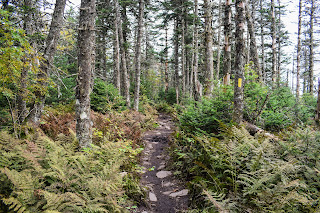
The hike starts following higher than a stream on an easy road and passes a neat foundation of an old spring house. This section of the hike was fairly easy - we enjoyed admiring the forest and all it had to offer (mostly pretty leaves and fungi!). The grade began to steepen, which began the longer slog-part of the hike. The forest was beautiful but the climb steady and unrelenting.
Eventually, the forest switches over to mossy conifers where the guidebook accurately describes as having an easier grade but worse footing (I preferred this section).
The trail turns to make a final ascent to the summit of Mt. Starr King, marked by a summit disc, and then opens to a view with an old fireplace. We didn't plan to take a break here, but a hiking family had their dog, named "Darby," come up to us and BEG for pets and scratches, so we took a nice break and chatted with them. The view was nice but very hazy.
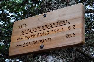
Continuing along, the trail between Starr King and Waumbek was straightforward, easily descending to the col, which was muddy in places, and then ascending up to the viewless summit clearing. We were alone and peaceful, yet underwhelmed. Slightly past the summit along the Kilkenny Ridge Trail there was a blowdown clearing that had a few obstructed views, which we enjoyed for a moment before turning around, but just then four Grey Jays appeared! I spent a good while taking photos of these beautiful birds - plus a woodpecker!
Our return trip to Starr King was easy, and we took one final break at the summit where we were joined by a family with two children who we spoke to on the trail earlier. They were feeding the Grey Jays, who were aptly named "Tom," "Jerry," and "Tyler" (Tyler was the nice one). They went on their way, and Sarah and I took potty breaks in the nearby woods, where I ran into the DEVIL HIMSELF - a male Spruce Grouse. He was perched up in a tree, but thankfully not beating his wings. Truly a beautiful bird, its a shame its chicken feathers are made up of pure evil. We took a few more photos, started our return trip, and then ran into another one, a femal Spruce Grouse! She was nestled on the ground, no more than 10 feet away from us. I'm grateful we found the chill ones today.
The rest of our return trip was quick and easy with only mild bats of absolute delusion from exhaustion. We somehow ended up running the final bit, but I don't mean running in a badass "train running" kind of way, more like a spooked white-tailed deer kind of way. We INHALED some food back at the car, admired the mountains we had just hiked from the drive home, and slowly made our way back to Boston. A great day in the north country!
Step-By-Step
- Start hike on Starr King Trial.
- Follow to summit of Mt. Starr King.
- Continue to summit of Mt. Waumbek (go slightly past for obstructed views).
- Retrace steps to car.
"Starr King Trail" from White Mountain Guide, 31st Ed. (2022)
RMC This yellow-blazed trail begins on Starr King Rd., a gravel road to several houses that leaves the north side of US 2 (trail sign) 0.2 mi. east of its jct. with NH 115A and 3.6 mi. west of its jct. with NH 115; the road is across from the entrance to Waumbek Golf Club. Go up the road, always bearing left to avoid driveways on the right, and then bear right into a recently expanded parking lot at 0.25 mi. If the parking lot cannot be reached by car (as when the across road is unplowed in winter), park in the plowed lot across US 2 and just west of Starr King Rd. and walk up the road; do not obstruct the road or driveways by parking cars on them. (Additional parking may be found 0.1 mi. farther west on US 2, next to a gas station, also on the south side.) Starr King Trail rises at a moderate grade all the way up, making a relatively easy ascent of a 4,000-ft. peak.
From the parking lot, ascend gradually on a logging road for 100 yd. Then turn left (arrow) and ascend another 100 yd. to meet the old route of the trail, an old logging road, on which Starr King Trail now turns uphill to the right and soon passes the stone foundations of a springhouse (right). At 0.7 mi., the trail bears right, soon ascends more steeply, and then swings right and then left onto the crest of the broad southwest ridge of the mountain through a beautiful mature hardwood forest. At 1.4 mi., the trail angles left into conifers and runs north on a long traverse of the west flank of the mountain, where the grade is easier but the footing is rougher. At 2.1 mi., in the middle of a rocky section, Starr King Trail passes a spring (sign) on the left (downhill side) of the trail.
Bearing right and leaving the traverse at 2.3 mi., Starr King Trail climbs steadily and then swings right again (south) for a short climb to the wooded summit of Mt. Starr King at 2.6 mi. The high point is a ledge on the right with a cairn and bench mark. The trail continues another 40 yd. to a viewless ledge and then turns left and descends 20 yd. to a clearing at the site of a former shelter, where there is a partly cleared view of the PResidential Range and more distant peaks in the central White Mountains. Starr King Trail enters the woods to the right of the remains of the old cabin’s fireplace (sign: “Path”), descends briefly northeast, swings right (east), and continues down along the north side of the ridge. The trail crosses to the south side and dips just below the col; then it swings left back up to the ridge crest and rises moderately to a small clearing at the summit of Mt. Waumbek (cairn, sign for Starr King Trail), where it meets the south end of Kilkenny Ridge Trail. (The sign for this trail is set back 15 yd. from the summit clearing.) About 50 yd. ahead on Kilkenny Ridge Trail, an opening in a blowdown area on the right provides a partly restricted view of the Presidential Range and more distant peaks to the south.


No comments:
Post a Comment