Northeast Corner of Ponkapoag Pond (Blue Hills Reservation)
Distance: 5.01 miles
Elevation: 364 feet
Elevation: 364 feet
Time: 1 hour, 41 minute (1 hour, 38 minutes moving)
Hike Type: Spaghetti Loop
Hiking Challenges: Blue Hills Winter Trace; 52 Hike Challenge 2024
Hike Type: Spaghetti Loop
Hiking Challenges: Blue Hills Winter Trace; 52 Hike Challenge 2024
The Hike
I had a nice Tuesday-afternoon drive after work to the Blue Hills with minimal traffic. My goal was to hit whatever I wanted on the eastern side of Ponkapoag Pond - no real plan, just a map with trails I haven't hiked in winter yet! It was 35 degrees, I forgot my camera clip (tragic), and I had to pee. Pretty standard after-work Blue Hills hike!
I got started on the Ponkapoag Trail and then turned onto the Prescott Foot Path, where I took care of my business on a rock that has become sort of a tradition for me. The lighting today was muted, but pretty - the sun was casting a gentle light through the clouds, and paired with the blue skies, created a similar ambiance as that once scene in the (wild) movie Saltburn where Oliver and the mother and chit-chatting outside while drinking cocktails (if you know, you know).
I meandered all around the old roads of the northeast corner of area, admiring the partially-frozen wetlands, excellent glacial erratics, and overall tranquility of hiking on these wide trails without anyone else. I admired the "ridge" feeling of Madden Road, and the solitude of the narrow Duck Pond Foot Path. I also accidentally spooked a small group of 2-3 deer.
I noticed, nearing Duck Pond for a second time, that the sun was beginning to peek through the clouds, could I actually see a sunset tonight? I picked up my pack down the Ponkapoag Path and through the AMC Cabins to a BEAUTIFUL scene of the sun setting behind the partially-frozen pond, which diffused the light magnificently.
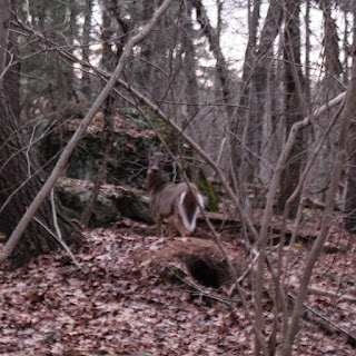
I wish I could have stayed longer, but I didn't have a headlamp with me (and I was hungry), so after taking at least 1,000,000 photos, I started my return trip. The sky changed from a dark yellow to a vibrant orange, and then a pale pink as I hiked along the paths. I took the Prescott Foot Path to the No Name Path to hit a few last needed trails, and then spooked another (or the same) family of deer right near the trailhead - one of the deer stayed close so I could get a photo - how kind!
Step-By-Step
- Park at Ponkapoag Trail parking (Exit 3 off I-93).
- Start hike on Ponkapoag Trail.
- At 5322, turn left onto Prescott Foot Path.
- At 5330, turn left onto No Name Path.
- At 5344, turn right onto Ponkapoag Trail.
- At 5343, turn around.
- At 5371, turn right onto Swamp Path.
- At 5365, turn left onto Fire Trail.
- At 5381, turn left onto Jones Link.
- At 5382, turn right onto Three Pines Path.
- At 5385, turn left onto trail to Duck Pond.
- At Duck Pond, turn around.
- At 5385, continue straight onto Hemlock Road.
- At 5384, turn right onto Fire Trail.
- At 5381, turn right onto Jones Link.
- At 5382, turn left onto Three Pines Path.
- At 5383, turn left onto Duck Pond Foot Path.
- At 5380, turn left onto Swamp Trail.
- At 5371, turn right onto Ponkapoag Trail.
- At 5374, turn right onto Madden Road.
- At turn, continue onto Three Pines Path.
- At 5385, turn right onto Hemlock Road.
- At 5362, turn right onto Ponkapoag Path.
- At next jct., turn right onto path.
- Cross Swamp Trail, hike toward AMC Cabins/Bathrooms, descend hill.
- Enjoy sunset at northwest corner of AMC Camp area.
- Return to 5364.
- At 5364, turn left onto Acton Path.
- At 5343, veer right onto Prescott Foot Path.
- At 5330, turn left onto No Name Path.
- At 5311, turn left onto Ponkapoag Trail.
- At 5241, turn around.
- Follow Ponkapoag Trail back to car.


No comments:
Post a Comment