Sunday, February 4, 2024

Mt. Garfield via Garfield Trail (White Mountain National Forest)

Mt. Garfield via Garfield Trail (White Mountain National Forest)

Distance: 12.47 miles
Elevation: 3,212 feet
Time: 6 hours, 31 minutes (5 hours, 24 minutes moving)
Hike Type: Out-and-Back
Hiking Challenges: New Hampshire 4000 Footers; 52 Hike Challenge 2024

The Hike
Okay, so I had my first snowshoe hike under my belt. I had an open day five days later, so I made a date for myself and Mt. Garfield! Garfield routinely comes up as a great "easier" 4000-footer, with easy/moderate grades almost the entire way up. It was going to be a long hike, 12ish miles with a road walk, but I knew I wouldn't need snowshoes for all of it (or apparently, any of it). I was feeling a little more condifent since my hike last Tuesday, the weather was supposed to be pristine, albeit cold and windy, and there hadn't been any new snow since last Tuesday, so it was safe to assume trails would be in good shape. Off I go!

The drive started like most, 3:00am wake up, boil some water for my Yeti and hot chocolate, skies were clear, air was cold, and I eventually made it to the MECCA - Hooksett. Unfortunately I didn't have to use the bathroom AND they did not have any breakfast sandwiches... oh well. A ham sandwich and some PopChips will do. I continued my drive, next stopping at the Lincoln 7/11 for a more productive bathroom run. I was feeling sleepy until I hit Franconia Notch which was stunning in the darkness - the Cannon Cliffs basically looked like the moon. After the notch, the clear skies became cloudy, and I soon landed at the winter trailhead at 6:00am, still in the dark. There was one other car in the lot, but it looked like someone was sleeping inside (foggy windows). Air temperature was 14 degrees, I wanted to sleep, but I told myself I could do hard things and got suited up! Thermal leggings (thank you Costco), tech pants (thank you Walmart - I need to upgrade these to ones that cover my boots and fit better), Darn Tough socks, SmartWool base layer, Outdoor Research microgrid fleece (my favorite article of clothing ever), L.L. Bean synthetic puffy (going to upgrade this too - probably a lighter-weight synthetic), Enlightened Equipment down puffy (basically used as a water-bottle insulator), Columbia shell (that will not be used), merino wool Buff, beanie, Head liner gloves, and Dakine insulated mittens - same clothes as my Bald Peak hike, and likely will stay the same clothes system. I also packed an extra base layer, buff, liner gloves, and socks in a Ziploc. My pack had the essentials including snowshoes, Hillsound trail crampons, 4 liters of Nuun, 1 Yeti of hot cocolate, and four peanut butter tortillas. My pack weighted 31lbs, and I was off!


The hike started at 6:20am at the gate to Gale River Road. A car pulled in as I was leaving and hiking around the gate. There were light flurries in the air and the road was covered in a beautiful, sparkly snow. I didn't realize there were first-come-first-serve campsites on this road. It appeared that there used to be more, though, as a sign read: "NOTICE: NO CAMPING AND NO WOOD OR CHARCOAL FIRES: Over the years, the high volume of camping and related human waste has caused damage to the vegetation an dis a threat to water quality in the streams. For this reason, the area is closed to camping. Please promote a clearn environment by not camping in this location."


Gale River Loop Road crosses the South Branch of the Gale River, which was beautiful in the early morning light. I took my puffy off and continued on. The road crosses the South Branch again, and then the Scarface Brook a bit later. I learned the hard way that trekking poles make a TERRIFYING sound when used on hard snow-crust - like a banshee coming for blood. Thankfully, I mentally adjusted, but I definitely spooked myself. The road turns left at a fork (snowmobile trail continues right/straight) to join a snowmobile route, crosses the South Branch one last time, and then finally arrives at the trailhead! I took a quick break here before continuing my journey.


I headed into the woods, which were very similar to the woods at the beginning of the Mt. Kinsman Trail. The trail meandered around these lovely woods for a short while before descending and turning onto the old firetower road. It wasn't super clear when this turn happened - the trail flowed very naturally. The biggest difference was that the trail was now traveling straight, instead of meandering. 


The trail then went through a wet area where it crosses the Thompson and Spruce Brooks, all of which were snow-bridged over. The trail continued on gently gaining elevation as the sky began to slowly brighten. I noticed the sky was beginning to appear through the clouds around 7:30am and I heard a truly magical owl call. 


Around the halfway point, the grade steepened slightly (not steep, though), and went up and over "Burnt Knoll," which is nestled in a stunning birch forest. I took a quick break here to get some water and I was STEAMING. It was down to 12 degrees, I had ice on my eyelashes, and my poor camera lens fogged up (but then iced over, which made for an easy cleanup). There was a short descent after Burnt Knoll, continuing in the stunning, relatively open birch forest, and then began the switchbacks!


I know some people, specifically New England hikers, who dislike switchbacks, but they were heavily appreciated as I was adjusting to carrying a heavy pack. By now, I was still in my bare boots and was working on transforming into a pine tree (my snowshoes kept getting caught on low-hanging branches). There were hundres of snowshoe hare footprints in the area, and just after the 5-mile mark I heard voices for the first time! A group of three snuck up on me and scared the life out of me, and then one final person passed me a few minutes later. It's very interesting stepping off-trail to let people pass when there's 2-feet of snow to sink into...


The forest began to lighten and become more snow-crusted with every switchback, which made the climb that more enjoyable. My toes began to get a bit chilly (which has never happened in these boots before), but thankfully it never got worse than a slight chill. There was an occasional breeze, but nothing too strong or prolonged. Slowly, the snow-crusted trees turned into "Dr. Seuss Trees" or "Cauliflower Trees," the sky began to open up, I entered the Forest Protection Area around the Garfield Ridge Campsite, and then I was at the Garfield Ridge Trail junction!


I took a short break here to gather my bearings and put my spike on - I knew it was supposed to be a short, steep final ascent. There were very partial views from this junction (and I mean like a view of just the tippy top of South Twin), and I noticed there were very few footprints heading away from Mt. Garfield on the Garfield Ridge Trail. 


I could't believe how blue the sky looked - it almost looked like someone edited the colors up above. 


The final push up to Mt. Garfield was tough. It was like an ice luge, but covered in granular snow. I made it up with a few slip-backs and post-holes, but the reward was an incredible view, sunny summit, and only a slight breeze. I passed the first group that passed me earlier right when I made it to the top of the climb, and the fourth person stuck around for a few more minutes at the summit.


On the left I could see Galehead, the Twins, the Presidentials behind the Twins, and the Bonds. Owl's Head was right ahead with a sharp ridge I had never noticed before. On the right was Flume, Liberty, Lincoln, and of course, Mt. Lafayette, with just the top of Cannon poking through to say hello. Air temperatures were up to 18 degrees, but with the breeze it was in the single digits. 

From left to right: Mt. Flume, Mt. Liberty, Mt. Lincoln, Mt. Lafayette, and Mt. Cannon.

South Twin Mountain.

Owl's Head.

From left to right: Mt. Guyot, Mt. Bond, West Bond, and Bondcliff.

I spent around 10 minutes up top taking endless photos, enjoying my peanut butter tortillas, and my still-mostly-warm-hot-chocolate! I love my Yeti. In hindsight, I should have bundled a bit more and taken a longer rest (with sitting), but I wanted to make sure I got back down with plenty of time to spare, so I packed my things and got back to work!


The initial descent down Garfield was very sketchy. I'm not sure if it was a mental issue or if it was actually rough, but it involved a lot of very small steps, slipping into post-holes, and contemplating just sitting down and flying (that would have been a poor decision). Right at the bottom of the steep section, I passed a group of 8ish hikers about to head up, so my timing was perfect!


I took a quick potty and hydration break back at the Garfield Trail/Garfield Ridge Trail junction, and then started the long journey back. Higher up, I continued to admire the thickly-crusted trees and the stunning blues of the sky. I passed probably around 20 people on my return trip, but all were well spaced out. At one point, I ducked under a low-hanging branch, which grabbed the hat right off my head, which caused me to flinch backward and fall into a deep posthole - basically a cartoon-style move. 


Lower down, I saw TWO red squirrels, thankfully neither of which were screaming at me, and I knew I was getting close first when I hit the brook crossings, and then when I could hear snowmobiles. At this point, my spirits were high, but my back was hurting. I'm not sure if it was fatigue, poor pack placement, poor pack packing, or a combination of it all. I took my final break at the summer trailhead where I spiked my remaining hot chocolate with the Vermont Ice Apple Cinnamon Cream Liqueur that Emma and I got at the Boyden Valley Winery a few weekends ago - DELICIOUS!


My final road walk back was uneventful. Thankfully I didn't have to deal with any snowmobiles. I admired the bridges as I traversed them, but kept it moving so I could put on clean, dry clothes. Back at the car I did a quick change, took a moment to be proud of myself for hiking my first winter 4000-Footer, and started my long, uneventful drive home.


[EDIT TO ADD] I haven't been this sore the day after a hike in a LONG time, probably since I hiked the Bonds. Oof!

Step-By-Step
- Park at the winter trailhead at Gale River Loop Road just off of US-3.
- Road walk to Garfield Trail trailhead.
- Follow Garfield Trail for its entirety.
- At terminus/first jct., continue right/straight onto Garfield Ridge Trail.
- Summit Mt. Garfield.
- Retrace steps to car.


“Garfield Trail”  from White Mountain Guide, 31st Ed. (2022)
[Mt. Garfield summit (4,501 ft.) via Garfield Ridge Trail: 5.0 mi., 3,050 ft, 4:00] 
WMNF This blue-blazed trail runs from Gale River Loop Rd. (FR 92) to Garfield Ridge Trail 0.2 mi. east of the summit of Mt. Garfield, which is bare rock with magnificent views. Most of the way the trail follows an old tractor road used for access to the former fire lookout, and its grades are easy to moderate all the way to Mt. Garfield, except for the short, steep pitch on Garfield Ridge Trail just below the summit. The trailhead for Garfield Trail is reached by leaving the south side of US 3 at a small parking area 0.3 mi. west of its intersection with Trudeau Rd. (a location sometimes called Five Corners) and 4.1 mi. east of its jct. with NH 141. Avoiding a right fork, follow FR 92 south for 1.2 mi. and then swing left and cross a bridge to a parking lot on the right. (Straight ahead on this road, it is 1.6 mi. to the trailhead for Gale River Trail.) FR 92 is not open to public vehicular use in winter; plowed parking is available at the road’s entrance off US 3. Garfield Trail lies within the watershed of a municipal water supply, and hikers and campers should take care not to pollute any of the streams in this watershed.
        Garfield Trail begins to the right of the parking lot, climbing an embankment and following the top of the north bank of the South Branch of Gale River through fine woods with many large hemlocks. At 0.7 mi., the trail descends, swings right toward the river, and then turns left onto the old fire lookout access road. It climbs slowly away from the river, heading generally south, and crosses Thompson Brook and two branches of Spruce Brook and then a snowmobile trail. Garfield Trail recrosses Spruce Brook at 1.2 mi. and continues its long, gradual climb. (Although these crossings usually are not difficult, in high water, you can use the snowmobile trail to avoid all three by bushwhacking up the east side of Thompson Brook, turning right on the snowmobile trail, and crossing bridges over both brooks - and also crossing Garfield Trail between the bridges - then bushwhacking up the west side of Spruce Brook back to Garfield Trail.)
        At 2.6 mi., the trail crosses a small brook by a large flat rock, and at 3.0 mi. it crosses a ridge (once burned over and known as Burnt Knoll) in a birch forest and descends slightly. At 3.3 mi. the trail swings left and ascends moderately on several sweeping switchbacks in mostly coniferous woods. It reaches a blowdown patch at 4.1 mi. Here, the trail turns sharply left and climbs easily to the east; then it swings south around the east side of the cone of Mt. Garfield to a jct. with Garfield Ridge Trail, which enters from the left, ascending from Garfield Ridge Campsite. The summit of Mt. Garfield is reached in 0.2 mi. by turning right and following a steep, rocky section of Garfield Ridge Trail to its high point and then scrambling over the ledges on the left for another 60 yd. to the foundation of the old fire lookout.

Saturday, February 3, 2024

Old Route 128, Burnt Hill, Monatiquot Path (Blue Hills Reservation)

Old Route 128, Burnt Hill, Monatiquot Path (Blue Hills Reservation)

Distance: 6.44 miles
Elevation: 472 feet
Time: 2 hours, 4 minutes
Hike Type: Spaghetti Loop
Hiking Challenges: Blue Hills Winter Trace; Blue Hills Grid

The Hike
Now that I'm officially complete with the 125-Mile Challenge, I'm back working on the Winter Trace full-time. I had a quick drive from one trailhead to the other - landing at the main parking area for Houghton's Pond. It was in the upper 30s now, the parking area was decently busy, I swapped my shoes from my winter ones to my normal trail shoes, I didn't have much of a plan, but off I headed!


I decided I would keep on-theme and focus with the Old Route 128 area without much more of a plan than that! I skirted past all of the people going on leisurely walks around the pond, and made my way toward the Andover Path/128 area. The ice that was left on the pond looked beautifully soft. Trails were in great shape! 99% dry with very VERY slight traces of snow left. 


I meandered my way onto the Burnt Hill Path, where there were a couple decent blowdowns, and at one point the sun was fully shining. I had to stop hiking and just sprawl my arms out Titanic-style to absorb as much Vitamin D as possible! The only complaint I had was that I forgot my buff and inhaler, but I would survive.


I followed the horrifically faint deer path to the summit of Burnt Hill, and then continued on toward 2111, where there were a few larger patches of light snow. I continued my wiggle onto the Bugbee, Doe Hollow, and Beech Hollow Paths. I noticed the further away I went into the park, the fewer people I saw, which was lovely. Also the classic irony that the more "remote" you are in this park, the closer you are to a highway. Almost counter-intuitive, but I'll take it!


I was getting tired by the time I hit the far corner of the area, but I knew I would be proud of myself and relieved if I sucked it up and got all these trails done. It was a very low-brain hike at this point - I just had my map open and kept moving until I hit them all! There was an impressive recent blowdown on  Monatiquot Path, but everything else was smooth sailing. Soon enough I was on my return trip down the Pipe Line and back onto Old Route 128.


I did take one detour on my return trip. At intersection 2085, there's an old trail on the left (highway side) that is unmapped. I decided I might as well check it out! It led to a culver over the Blue Hill River and terminated at a large boulder. Pretty unexciting, but fun to explore something new! It seemed decently traveled up until the very end, even without being on a map.


My last bit of excitement was on my final return to the car - I group of 8ish teenage girls, who I assume were out on their first hike, were engaging in a wildly loud footrace across the field. They were shocked at how winded they were, and noted that they had to ration their one water bottle. I hope they had a lovely day! Once back at my car I zoomed home, had lunch, showered, and submitted my 125-Miler form to get my patch!


Step-By-Step
- Park at Houghton's Pond main parking area.
- Start hike by walking past Houghton's Pond Visitor Center, Bathhouse, and then to trail between Andover Path and Old Route 128.
- Hike trails between Andover Path and Old Route 128, landing on Andover Path.
- Turn right onto Andover Path.
- At terminus, turn left onto Burnt Hill Path.
- Summit Burnt Hill, continue on Burnt Hill Path.
- At 2111, turn right onto Bugbee Path.
- At 2129, turn right onto Doe Hollow Path.
- At 2132, turn right onto Beech Hollow Path.
- At junction, hike out-and-back to 2123.
- Back at junction, turn right to hike to 2146.
- At 2146, continue onto Oblique Path.
- At 2163, turn right onto Sullivan Trail.
- At 2176, turn left onto Pipe Line.
- At 2189, turn left onto trail.
- At 2190, turn left onto Bugbee Path.
- At Fern Spring Foot Path (jct. after 2155), turn around.
- At next junction (2155), turn right onto Oblique Path.
- At 2150, turn left onto Old Route 128.
- At terminus, continue onto Monatiquot Path.
- Hike spur to MA-28, then continue on Monatiquot Path.
- At next junction, turn right hike Pipe Line spur to MA-28, then turn around.
- At same junction, turn right to hike last bit of Monatiquot Path, then turn around.
- At same junction, turn right onto Pipe Line.
- At terminus, turn right onto Old Route 128.
- At 2085, turn left to hike unnammed, unmapped path to Blue Hill River, then turn around.
- Turn left back onto Old Route 128, then hike back to car.

Friday, February 2, 2024

Braintree Triangle (Blue Hills Reservation)

Braintree Triangle (Blue Hills Reservation)

Distance: 1.67 miles
Elevation: 49 feet
Time: 33 minutes
Hike Type: Out-and-Back, Lollipop Loop
Hiking Challenges: 52 Hike Challenge 2024; 125-Mile Challenge (2x)

The Hike
It's time to officially complete the Friends of Blue Hills 125-Mile Challenge for the second time! (Thankfully they have a second round patch!) It was a cool morning at 32 degrees. I had a slow start to my day and didn't get to the trailhead until after 11am. There were a few cars at the trailhead, and I got right to work!


I started on the Hemlock Path as an out-and-back, which doubled as my breakfast time becuase I realized I also forgot to eat breakfast... whoops! The Kirkland protein bar fueled my easy walk to I-93 and back. I really like the end of this trail - full of old artfacts like bricks, bottles, and some road infrastructure. 


The surrounding wetlands were partially frozen and the walk along Old Route 128 was peaceful. I even noticed the sun was trying to break through the clouds for the first time in over a week! Once on the Elm and Winnemoiset Paths I found myself imagining what this area must have been like when it was still a part of the reservation - before the construction of I-93. It's really neat to think about!


Soon enough, I was on my return trip, and my challenge was over! All in all I hiked 172.08 miles and 19,976 feet of gain for this challenge over 32 different hikes. It was fun to revisit areas of the reservation I hadn't been to in a long time, and even more fun to "rediscover" areas that I had fully forgotten about. Moving forward, I'm going to continue working on AMC's Winter Trace (which is what I'll be doing in no less than 30 minutes), the Blue Hills Grid, Great Blue Summits, and tracking miles hiked in the reservation as I work toward 1,000 (I recently hit 500!). 


Step-By-Step
- Start hike by walking across Old Route 128 and continuing along Hemlock Path.
- At terminus (I-93), turn around.
- Back at Old Route 128, hike west on Old Route 128.
- At 5611, turn right onto Elm Path.
- At terminus, turn left onto Winnemoiset Path.
- Follow loop, bearing left, back to Old Route 128.
- Return to car.


Tuesday, January 30, 2024

Bald Peak via Mt. Kinsman Trail (White Mountain National Forest)

Bald Peak via Mt. Kinsman Trail (White Mountain National Forest)

Distance: 4.48 miles
Elevation: 1,391 feet
Time: 3 hours, 48 minutes (3 hours moving)
Hike Type: Out-and-Back
Hiking Challenges: N/A


The Hike
First trip up to the Whites in 2024! I took a mental health day off of work (read as: played hookie), got up at 4:00am, had a LONG search for my wallet (it was in my lunchbox/shopping bag), and started my drive after 4:30am. It was misty out for quite literally the entire drive, which, paired with temperatures between 24 and 28 degrees, made for a very interesting, slow drive. The stretch to Hookset was rough, BUT I was blessed with needing to use the bathroom (better here than the woods) and breakfast sandwiches! The rest of the drive was slow, wet, and slippery. I stopped at the Lincoln McDonalds for a final bathroom break and then started my drive along 112 and then 116 which was just beautiful. The trees were frosted in white and I almost pulled over to get a photo of the Beaver Brook Trailhead just because of how gorgeous it was. The mountains began to peek through the clouds, but it was not looking too promising for me. I was definitely feeling nervous, with my 31lbs pack (new record!) and that this would be my first time snowshoeing (also first time snowshoeing up a mountain), but I was going in realisticly with my goal being Bald Peak and my dream being the Kinsmans. The trailhead had 2-3 inches of fresh powder, it was 24 degrees, the air was still, I got dressed, and the adventure began!


Right away, the trees were beautiful marshmallows, and I had plenty of time to admire them as I was hiking very slowly to account for the weight. My fleece was taken off after five minutes and I was an absolute disaster maneuvering my full pack (dropped my camera in the snow - its taken a beating before, but the poor lens...). After a few more minutes my spikes went on, just adding to my glacial speed. I wasn't bothered though, the woods were absolutely beautiful. 


I made my way into the hemlock grove mentioned in the guidebook which was equally beautiful and mysterious, and I admired how well blazed this trail was. I made my way onto an old logging road, where the snow was a bit deeper, but grades were nearly flat. At this point I began to wonder when it would be appropriate to put on snowshoes, but then I thought about how this would be perfect timing because 1) I've never worn them before and 2) the trail was currently flat so I would have a moment to get my clumsiness out of the way. At the 0.9 mile mark snowshoes went on rather smoothly (thank you Costco), and I was off again!


My first impressions on the snowshoes were... weird. I had to step wider and be more intentional with my foot placements. My hips soon became sore, but apparently that's likely just muscles getting used that never get used. Over time, I began to adjust. I kept it snow and steady with small steps, generally leading with my thigh/knee. When the trail began to pick up in grade, I kicked up the televators, which I am a big fan of! I felt so fancy using my poles to pop them up and down.


I continued my climb, doing a horrible job at not sweating. Thankfully, temperatures remained in the 20s with no wind at all. I was just happy to be in such a beautiful forest! Near the halfway point it began to flurry, but nothing ever more than that. 


I do need to get gaiters and snow baskets for my poles, but besides that I was very happy with my equipment. I continued to follow dozens of adorable bunny tracks as I ducked under trees that were weighed down by the recent snow. I soon became a monster, smacking branches with my poles to relieve some of the weight on the branches so I could get under unscathed (moderate success, I had MUCH snow falling down the back of my shirt).


I eventually made it to a few stream crossings - one of which was fully frozen over - I only knew it was a water crossing from the sound of a cascade underneath! The snow bridges were excellent, but definitely made me feel uneasy. Before I knew it, I passed the spur to the flume, which I did not take on this day (not trying to tempt fate), and not too much after, made my way to the Bald Peak spur!


At this point, I had made the decision to not continue to the Kinsmans. This would only be the halfway point up the mountain, I was having a great day, and my hips were hurting. I would rather have my first snowshoe adventure end positively than in pain. I began my trek to Bald Peak, which was more intense in terms of snow and postholes than the main trail. There were some postholes over two feet deep. The trail was short and narrow, with even more bunny tracks! 


I hit the final push and I was very happy with where I had landed. The summit of Bald Peak is wide open with a PERFECT sitting rock. Views were minimal, yet beautiful, with clouds rolling in and out. I think if I was able to see the ridge from here I might have been more tempted to go all the way to the Kinsmans, but it was still deep in the clouds - another day! I had a nice break up here. 


Getting back to the junction was quick and easy, and I had a moment of peace standing still in the silent woods, with only a woodpecker keeping me company. It was so nice to be here. My return trip was simple and straightforward - following my little baby snow trench. I didn't see a single human until my last mile. They were kind, but not wearing snowshoes, and chewing up my hard work! In their defense, I would argue snowshoes weren't necessary except for maybe the last bit up to Bald Peak, but I still worked on hard on the satisfying trench! They sounded like they were going up to the Kinsmans - hope they made it okay!


Soon enough I was back were I began at the trailhead, feeling very accomplished and hungry for more! I had a relatively quick drive home (in comparison to my drive there), with just a quick stop at Hooksett. My hip soreness wore off and I was feeling good! I'm glad I didn't go all the way up, becuase now I got to take a nap once home, but I'm excited to get back out soon!


Step-By-Step
- Park at Mt. Kinsman Trail parking.
- Hike on Mt. Kinsman Trail until junction with Bald Peak Spur.
- Hike on Bald Peak Spur to Bald Peak.
- Retract steps to car.

"Mt. Kinsman Trail" from White Mountain Guide, 31st Ed. (2022)
WMNF This trail climbs from the east side of NH 116 to Kinsman Ridge Trail, 0.4 mi. north of North Kinsman. The trailhead, with a short road leading into a large dirt parking area (usually not plowed in winter, in 2021, the entrance had a small washout to watch for), is 4.7 mi. south of NH 18 in Franconia, just beyond the Tamarack Tennis Camp, and 6.4 mi. north of NH 112 at Bungay Corner; this is 1.7 mi. north of the Easton town hall. Mt. Kinsman Trail climbs at mostly moderate grades.
        The blue-blazed trail leaves the southeast corner of the parking area and in 20 yd. turns sharply left and ascends moderately through a brushy area. At 0.2 mi., the trail enters an attractive hemlock forest, dips to cross a small brook, and ascends generally eastward. At 0.5 mi., the trail swings left and levels off, crossing an unmarked mountain-bike trail, and in another 30 yd. turns right onto a logging road, joining an older route. (In the reverse direction, turn left off the road onto a footpath at a sign.) The trail soon swings left, passes an old sugarhouse on the left at 0.6 mi., and swings right again.
        Mt. Kinsman Trail enters the WMNF at 1.1 mi., turns right off the road (cairn and arrow), and in 30 yd. turns left onto another road. This older, steeper road crosses a brook at 1.5 mi. near the site of the former Kinsman Cabin (up on the left). At 1.8 mi., Mt. Kinsman Trail crosses Mossy Falls Brook, which flows over a mossy ledge to the left of the trail, and then crosses Kendall (Flume) Brook at 2.1 mi. Just over the brook, a side path on the right (sign: “Flume”) descends close to the brook bank for 150 yd. to the top edge of a small, steep-walled Kinsman Flume, a classic eroded dike (use caution here). Mt. Kinsman Trail continues on the road for another 70 yd. and then turns sharply left at the point where a yellow-blazed 0.2-mi. Spur path (sign: “Bald Peak”) diverges sharply right, descends briefly, then makes an easy ascent to Bald Peak, a bare, ledgy dome with fine views that crowns a western spur of Kinsman Mtn. [...].


Saturday, January 27, 2024

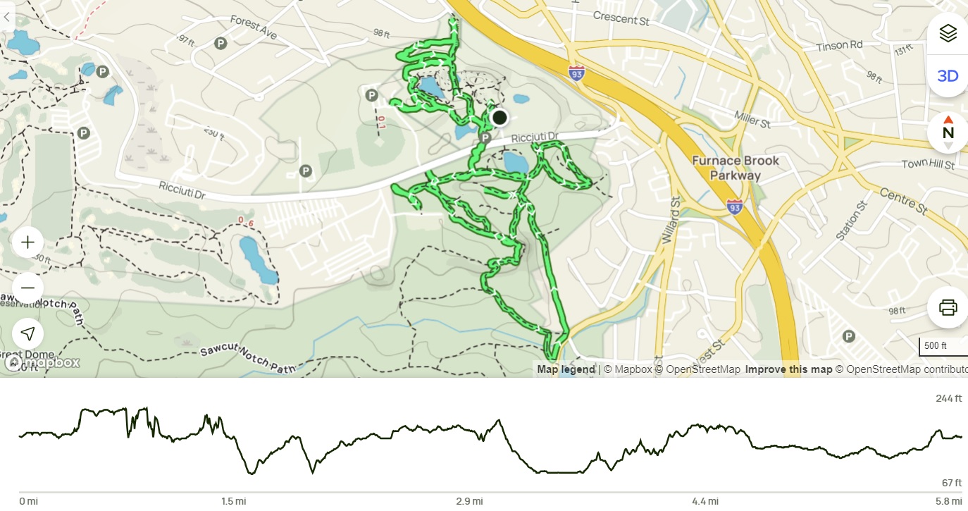
Full Quincy Quarries (Blue Hills Reservation)

Full Quincy Quarries (Blue Hills Reservation)

Distance: 6.14 miles
Elevation: 525 feet
Time: 2 hours, 21 minutes
Hike Type: Messy Loop
Hiking Challenges: 125-Mile Club (2nd Time); Blue Hills Winter Trace

The Hike
Okay. It was TIME. I was going to conquer the Quincy Quarries! Last time I attempted this area, I got very overwhelmed and was simply not having fun anymore, so I cut my journey short, BUT I did get very close to finally connecting the dots. It was 35 degrees out, misty air, and I was going in determined, but with an open mind. 

PART 1: THE UPPER QUARRIES
I started my adventure hiking the trail to the pinnacle of the Granite Railway, all while admiring how vibrant the graffiti looked on the wet rocks. I also admired how carefully I was walking, while admiring how vibrant the graffiti looked on the wet, slippery rocks. I was going to do everything on this side twice, to make sure I got everything I needed for the 125-Mile Challenge and AMC's Blue Hills Winter Trace. 


Afterwards, I wiggled my way toward the Little Granite Railway Quarry and the ballfields. The trails here were really pretty, but I just wish there were intersection markers or SOMETHING to help navigate. At the terminus of the trail with the ballfield parking, there is a mattress that's been there for at least two years now - at least that's a constant! On the inner trail along the Little Granite Railway Quarry there are some neat overlooks, but the ground was VERY mushy and slippery, so I did not tempt fate. I hiked this section one and a half times, and planned to do a smaller second lap.


Continuing on, I made my way to the west side of the Little Granite Railway Quarry, which had more interesting views, and I very carefully worked my way onto what I hoped was the trail that leads to 4229. It turns out, there are roughly three parallel trails that head in this direction - I was on the uppermost, which skirts the base of the granite wall of the Little Granite Railway Quarry.


Next, I skirted along the landfill of the Granite Railway Quarry, which was partially flooded, but bridged. The water was partially frozen and looked horribly polluted. From here, I completed my faster, second lap.


I then descended to hike the Granite Railway Incline, awkwardly passing the same person numerous times. I was HORRIFIED to then find the 4229 intersection marker not where I thought it was supposed to be. Did I hike the wrong trail?? [EDIT: I mentioned this on the 125-Mile Club Facebook group, and Bob Vogel confirmed that it was misplaced and the first route I took was correct - yay!]. This trail went through old fenceposts and followed a stream, but the trail quickly fizzled out at the site of some old, rusted, abandoned cars. An old road/railbed emerged after that, but also fizzled out. I eventually connected to the middle of the three parallel trails, so if anything, at least I'm hiking everything!


I did this loop again and then headed back toward the parking area - the northern quarries were officially complete! I am still curious if the 4229 sign is misplaced, but I felt very accomplished nonetheless!


PART 2: THE LOWER QUARRIES
Now things were about to get interesting! I crossed Ricciuti Drive, entered the woods just west of the parking area, and stared by hiking the western side of things. I needed all of this area for both maps, so there was A LOT of backtracking. I meandered to the western terminus, hit the trails near 4238 and then... then I decided I was going to go for it. I was so close to connecting the dots last time, I had a weird, feral determination to do it all!

I followed the Quarries Foot Path  and the side trails to the area I call the "parking lot" - three-ish granite rectangular prisms that one would usually find in a parking lot, heading a party area filled with broken glass and crushed cans. From there, I slowly followed what I thought could have been the trail, cross-referencing AllTrails, until I saw it down below - the Quarries Foot Path I had been on before! I connected the dots!!! It was such a thrill, even if I was cranky about it. I sat-and-scootched down a lichen-covered granite slab, and gleefully hiked down to 4223.


From 4223, I went over the Bunker Hill Lane and hiked back in. Thankfully I had already done the silly rock scramble that doesn't even have a trail, so now I only had to connect the dots to what I had already done. I did some back-and-forths around 4236, made my way back to 4238, hiked past Berry's Quarry, which had a strange man doing... something, and then made my way into the meadow west of 4236, which had a collapsed tent and was partially flooded... interesting.


Finally, I hiked the random loop on the east side of this area, passed the man at Berry's Quarry, who was now lighting a campfire? And made my way back to the parking lot! Quincy Quarries have officially been conquered!! I am equally proud, excited, and relieved. Now I don't have to go back for a long time, when I'll get to do it all again.


Step-by-Step
I truly tried to type this out, but with the lack of intersection numbers/trail names, it immediately became too confusing. I did the upper section twice, the section just south of Riccuiti Drive twice, and then the lower section once. It was a journey!

THE GRANITE RAILWAY
The Granite Railway, originally built to carry stone quarried for the Bunker Hill Monument was among America's first railroads. The Granite Railway Inclined Plane was a remarkable feat of engineering.

1830
When the Bunker Hill Monument Association did now renew the contract with the Granite Railway Company to haul stone from their quarry in the West District the Granite Railway Company opened their own quarry here at Pine Hill Ledge. Gridley Bryant designed and built the Inclined Plane to transport granite down from the ledge to the existing railway that ran to it's wharf at the Neponset River.
        Rendering of the Inclined Plane railway by local artist Ruth Haderski shows the Inclined Plane as it may have appeared in 1830 based on Gridley Bryant's memoirs and the remains we see today. The following is a letter from Gridley Bryant's memoirs written to a friend describing the Inclined Plane. 
        "The Inclined Plane was three hundred and fifteen feet long, at an angle of about fifteen degrees. It had an endless chain, to which the cars were attached in ascending or descending. At teh head of this inclined plane I constructed a swing platform to receive the loaded cars as they came from the quarry. This platform was balanced by weights, and had gearing attached to it in such a manner that it would always return (after having dumped to a horizontal position, being firmly supported on the periphery of an eccentric cam. When the cars were out on the platform there was danger of them running over, and I constructed a self-acting guard, that would rise above the surface of the rail upon the platform as it rose from its connection with the inclined plane, or receded out of the way when the loaded car passed on the track; the weight of the car depressing the platform as it was lowered down. I also constructed a turn - table at the foot of the quarry, which is still in use (1859) as originally constructed. The railroad was continued at different grades around the quarry, the highest part of which was ninety-three feet above the general level; on the top of this was erected an obelisk or momument forty-five feet high."

1890
After the Granite Railway Company sold the railway right of way from West Quincy to the Neponset River to the Old Colony Railroad Company, standard gauge rails were laid over the original Inclined Plane. The quarry operation now could use standard gauge rail cars to transport granite from the quarry to its cutting sheds and for shipment by steam locomotive to any destination in the country. The endless chain system was still being used to control the cars in their ascent and descent from the quarry.

1920
In 1919 the Granite Railway Company upgraded the Inclined Plane again so that motor trucks could now be used in transporting granite from their quarry to their stone sheds at the base. Channel iron rails were placed over the original railbed and motor trucks were assisted in descent by a cable winch at the top of the inclined plane.

EXCAVATION
A section of the original 1826 Granite Railway was excavated in 1957 by archeologist Richard Muzzrole during the construction of the Southeast Expressway. Over three miles of the original railway was excavated and used for fill in the construction of the expressway. The expressway now follows the approximate route of the Granite Railway as it ran to the Neponset River. The archeological excavation shows the original stone foundation and the granite sleepers minus the wooden rails and the strap iron that was attached to the top of the rain. In the photo to the left can be seen the protruding wooden sleepers of the Old Colony and New York New Haven and Hartford Railroad tracks that were laid over the original 1826 railway. The 1826 railway originated at the Bunker Hill Quarry located about one mile southwest of here and terminated at the wharf at Gulliver's Creek and Neponset River. The railway was abandoned in 1829 when the Bunker Hill Monument Association did not renew it's contract with the Granite Railway Company to haul stone for the monument. WIth the loss of the contract the Granite Railway purchased the ledge at Pine Hill and started quarrying stone. To move the granite down from the ledge to their railway level, Gridley Bryant designed the Inclined Plane rail system and the railcars to transport the granite to the base of the incline plane. Gridley Bryant also designed a turn table located on the 1826 railway that is buried some where beneath where you are standing. 

THOMAS HANDASYD PERKINS
PRESIDENT GRANITE RAILWAY COMPANY
Colonel Thomas Handasyd Perkins was born December 15, 1764, one of 10 children of James and Elizabeth Perkins. At the age of 15 he began working in the shipping business and in 1785 when he turned 21 he launched his business career as a merchant and financier. In 1785, when China opened the port of Canton to foreign businesses, Perkins was one of the first Boston merchants to engage in the Chila trade. Perkins was the driving force in the building of the Bunker Hill Monument and the building of the Granite Railway. He served as president of the Granite Railway Company from its establishment in 1826 until 1834. In later years, Perkins became a philanthropist to many organizations through out Boston, one of which was the Perkins School for the Blind. Perkins died on January 11, 1854.

GRIDLEY BRYANT
ENGINEER AND BUILDER
Gridley Bryant was born on August 26, 1789 in Scituate, Massachusetts. Bryant's opportunities for schooling were limited, amounting to only a few months in each year in a common country school in Scituate. At the age of 15, Bryant was apprenticed to a prominent builder in Boston. At 21 he commenced business as a builder on his own. Bryant was a self-taught engineer. He always had a great desire for books, especially those of mechanics. His skills, industry and energy secured many important contracts with the United States government. Bryant's early inventions include the portable derrick, four and eight wheel rail cars, railway turntables and many types of railway switches. Bryant never patented any of his inventions, stating "I have abandoned to the public all my inventions for the public good." Gridley Bryant died on June 13, 1867 at the age of 77.

RAILCAR
A cross section drawing by archeologist Richard Mozzrole of the original 1826 railway and railcar positioned on the rails showing details of the construction of the roadbed. Two three feet deep trenches were dug about six feet apart and stones were placed in the trenches to make a dry wall foundation. Granite sleepers were placed across the two walls every eight feet, the entire length of the railway. Pine rails eight inches by six inches by sixteen feet long were fastened to the granite sleepers with iron rods. The rods were used at the joins to keep the rails from twisting out of alignment. A two inch by four inch oak rail was nailed to the pine rail with spikes. An iron strap ran two and one half inches wide by three disteenths of an inch thick was nailed with spikes to the oak rail. The total length of the Granite Railway was about three and one half miles long from the Bunker Hill Quarry to the Granite Railway ____ at Gullivers Creek at the Neponset River. The guage of the railway was five feet and between the rails was loose dirt for the horses to walk on. The wooden rails did not last due to the heavy loads and were replaced with granite rails around 1829. The iron strap rails were salvaged from teh wooden rails and reused on the granite rails.